All Activity
- Past hour
-
 So far we have had 4 summers since 2017 with the highest temperature of the year occurring in June or not getting surpassed later in the summer. This is a first for our area over such a short period of time. It makes years like 1953 even more challenging to match with 105° heat in September. Since heat getting established early peaks before we get to August and September. Monthly Highest Max Temperature for NEWARK LIBERTY INTL AP, NJ Jun-Aug Max Temps Click column heading to sort ascending, click again to sort descending. 2025 103 101 96 103 2021 103 97 99 103 2011 102 108 98 108 1994 102 99 95 102 1993 102 105 100 105 1952 102 98 92 102 1943 102 95 97 102 1988 101 101 99 101 1966 101 105 95 105 2024 100 99 100 100 1959 100 93 96 100 1953 100 99 102 102 1934 100 98 90 100 1923 100 99 92 100 2017 99 98 93 99 Monthly Highest Max Temperature for LAGUARDIA AIRPORT, NY Jun-Aug Max Temps Click column heading to sort ascending, click again to sort descending. 2025 101 100 91 101 2017 101 98 91 101 1952 101 97 90 101 2021 100 96 98 100 2008 100 97 88 100 1988 99 99 97 99 1956 99 94 92 99 1943 99 91 93 99 2012 98 101 93 101 1959 98 91 94 98 2024 97 97 95 97
 -
heh... great. more subjective word maze popsicle headache. Yeah I dunno. 'for me' I'm okay with deep summer being 83/62. It's not winter. It's not autumn nor spring. It's summer, and above climo for August 20. But again, it's a semantic waste of time. 90/70 is just hot; deep summer needs to be in place, first.
-

Hurricane Erin: 110 MPH - 943 mb - N @ 13
Wannabehippie replied to BarryStantonGBP's topic in Tropical Headquarters
As we say goodbye to Erin, and go on to the next storm. 8:00 AM EDT Thu Aug 21 Location: 34.8°N 71.8°W Moving: NNE at 17 mph Min pressure: 945 mb Max sustained: 105 mph -
I'm super pumped for this severe weather class. Skew T's, Log P's (don't know much about those though), thermodynamic review (prob screwed there). shear, hodographs, soundings, and so much more and final project is a case study
-
I think there’s another force here too….we overestimate our ability to forecast winter previously as well. We had some “classic” behavior in the 2003-2012 period where the El Niños and La Nina’s were acting very much like we “expect”…so maybe we created a recency bias for a time until things “broke down” circa mid-2010s…some will argue 2013 with the big N ATL changes and others will argue Super Nino 2015-16, but either way it was around that time. However, one only needs to look back to decades past to see how many ENSO events/winters didn’t act like we “expect” them to. Some of the early 1950s winters behaved very similarly to our recent winters but just a warmer baseline now. They were still very warm in the means, especially over New England and SE Canada. The El Niños in the late 1960s basically acted as La Niñas (particularly 1968-69)…even the super Nino in 1972-73 was not like others. Probably a lot of -PDO hangover influence. The 1980s had their own bizarre quirks and then we have the famed ‘95-96 winter which was a La Niña but had an active STJ more akin to El Nino which contributed to the wildly positive snow anomalies in the mid-Atlantic. Those are just the ones off the top of my head. I try to keep the early 1990s in their own category due to the influence of Pinatubo. There was some radical stuff going on there (we’ve talked about this previously but the extreme cold in the 1992-1994 period was likely not a coincidence.) There’s definitely new quirks going on as we warm different parts of the planet at different rates, but I’m not convinced we truly have some permanent new paradigm where most of the old rules don’t apply. History tends to rhyme including weather history…we might have an underlying baseline that is warmer, but I hesitate just throwing out previous references and rules. Not saying you are going that extreme, but more just a general comment on winter forecast and it’s a sentiment I’ve seen elsewhere.
-
of course that's not intended to mean we can't get a bombed this year either... just sayn'
-
Talking early in the week when Monday and Tuesday were cloudy and wet at the beach with mostly cloudy skies and mist. Areas back home had sun in Northern De., and PA was mostly sunny. The front stalled, more onshore flow and what was forecasted as sunny turned into cloudy conditions for the Southern areas. Erin's impact on Dewey's weather was more mid to late week. Today being the worse of the last four days here. I need more orange crushes today.
-
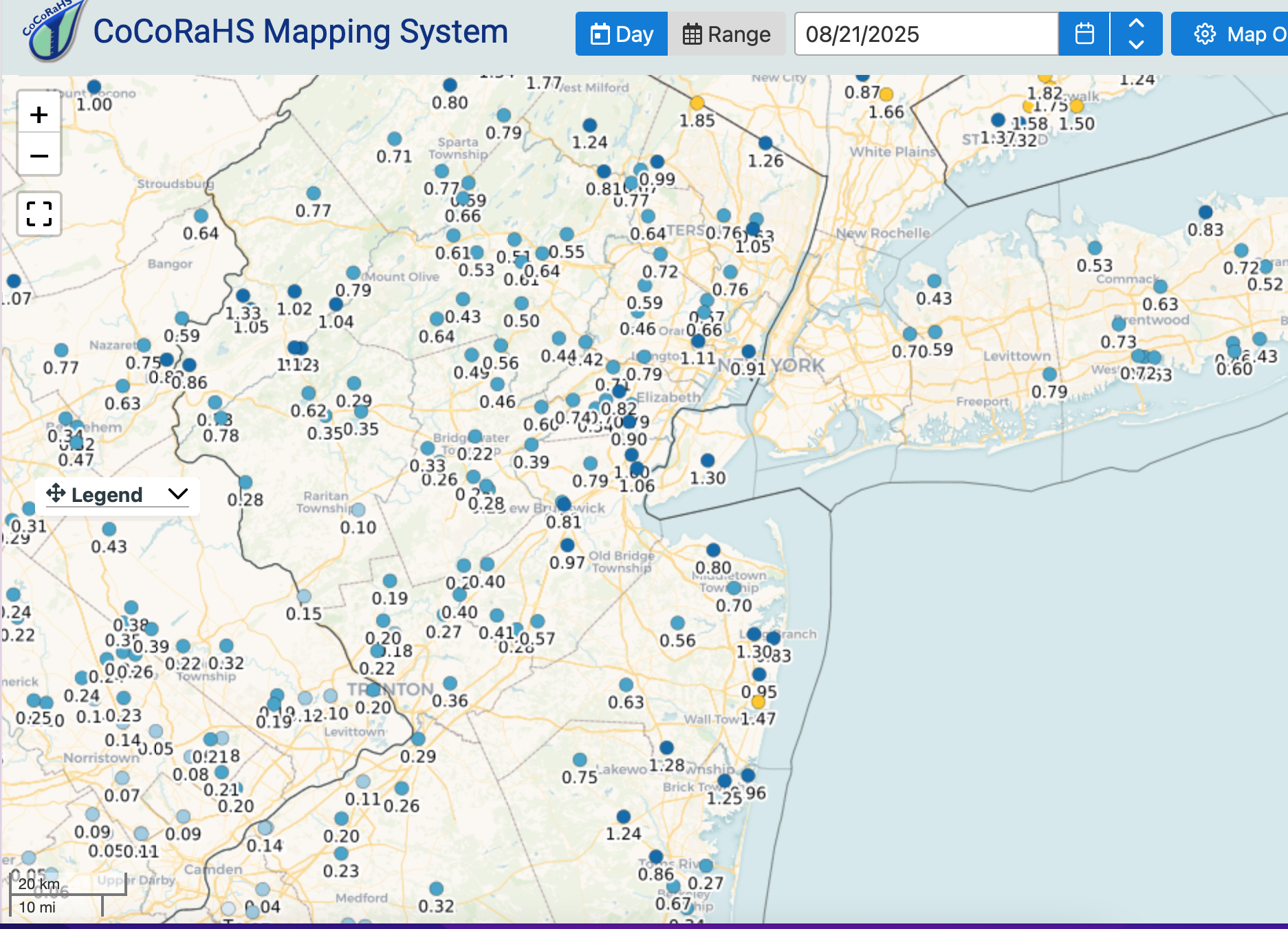
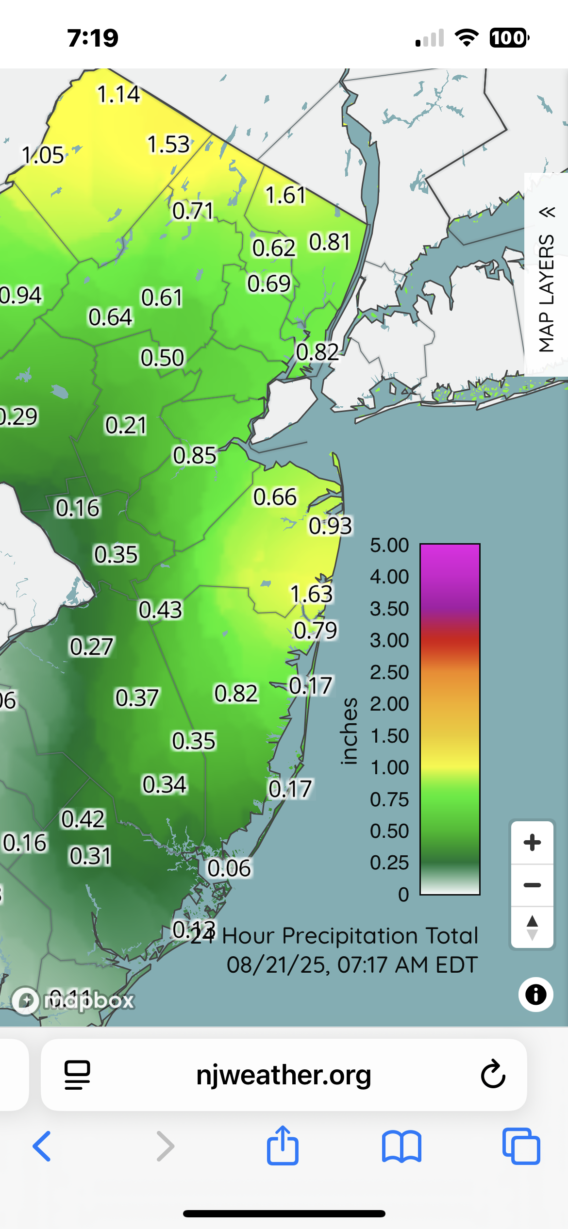
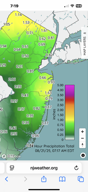
 With this rain I'm at 1.13" of rain for the month, so the area can use it. I have an irrigation system, so I'm good, but many neighbors lawns and flowers are looking quite thirsty. Seems like from Walt's map above, a decent amount of NJ South of 78 and away from the coast were in the shaft zone. My black walnut tree seems to be dropping leaves already. It is usually the last to leaf out and the first to drop leaves, but this is early.
 -
 I don't remember if you needed the rain or not but you did get shafted with this, you have one of the lowest totals in the area. I got skunked a bit as well considering the surrounding amounts, northern Queens and Nassau had between 0.4 and 0.6 but closer to an inch just a couple miles south of me and much bigger amounts just north as well.
 -
Same here, .23"
-
This stuff is more appealing in a 1992 planetary climate for me. Not so sure I vibe with that now that we've evolved to a 2025 state of global climate affairs. Most of the outlooks and conjectures I've read or heard are clad enough relative to classical modes ( longer termed telecons, air/ocean/land ...etc), but don't consider a consistently observing winter circulation modes being unstable, despite those efforts. And thus ...less predictable, more so than usual - higher variance including at times unusually large correction ranges ( warm vs cool ), that for lack of better words, flout the governing/preceding indicators. More occurrences of anti-correlation. This instability was always clearly predicted by climate models and so interesting enough appears to be manifesting... I'm not sure I see a compensating mechanism that caps that manifestation from doing the same thing. I realize I've been sarcastic at times in mockery over having this winter just being like the last 7 or 8 consecutive ones/8 number of years, but there is modicum of valid reason in that humor. Because simply put, the 'disruption' aspects having been getting in the way of all intents and purposes ... with enough consistency and a large enough sample size to dim confidence in the reliance on classical application.
-
90/70 at ASOS like mid-summer is what “deep” is to me.
-

2025 Atlantic Hurricane Season
BarryStantonGBP replied to BarryStantonGBP's topic in Tropical Headquarters
Watch Fernand and Gabrielle be weak and short lived Could get Fernand off the red blob 99L might go into the BOC and become Gabs Humberto = have to wait until late september 2024 had a similar pace as well with Fran forming in early September in the Gulf -
I am really sorry to hear this. I met him once at a SE weather meeting. He was a really nice person. It would be great to get a big snow this year in his memory.
-
Looks like a fishy reading but technically Savannah-Hilton head airport dropped to a dewpoint of 62 on Monday, breaking the streak of dewpoint at or above 68 degrees, which ranks third highest all time
.thumb.png.85ea443c61a71a314ee834f9afa9c725.png)
-
 Nice job sniffing all this out Walt ! Excellent work as always.
 -
What? You’re thinking when I just had temp sensor years ago
-
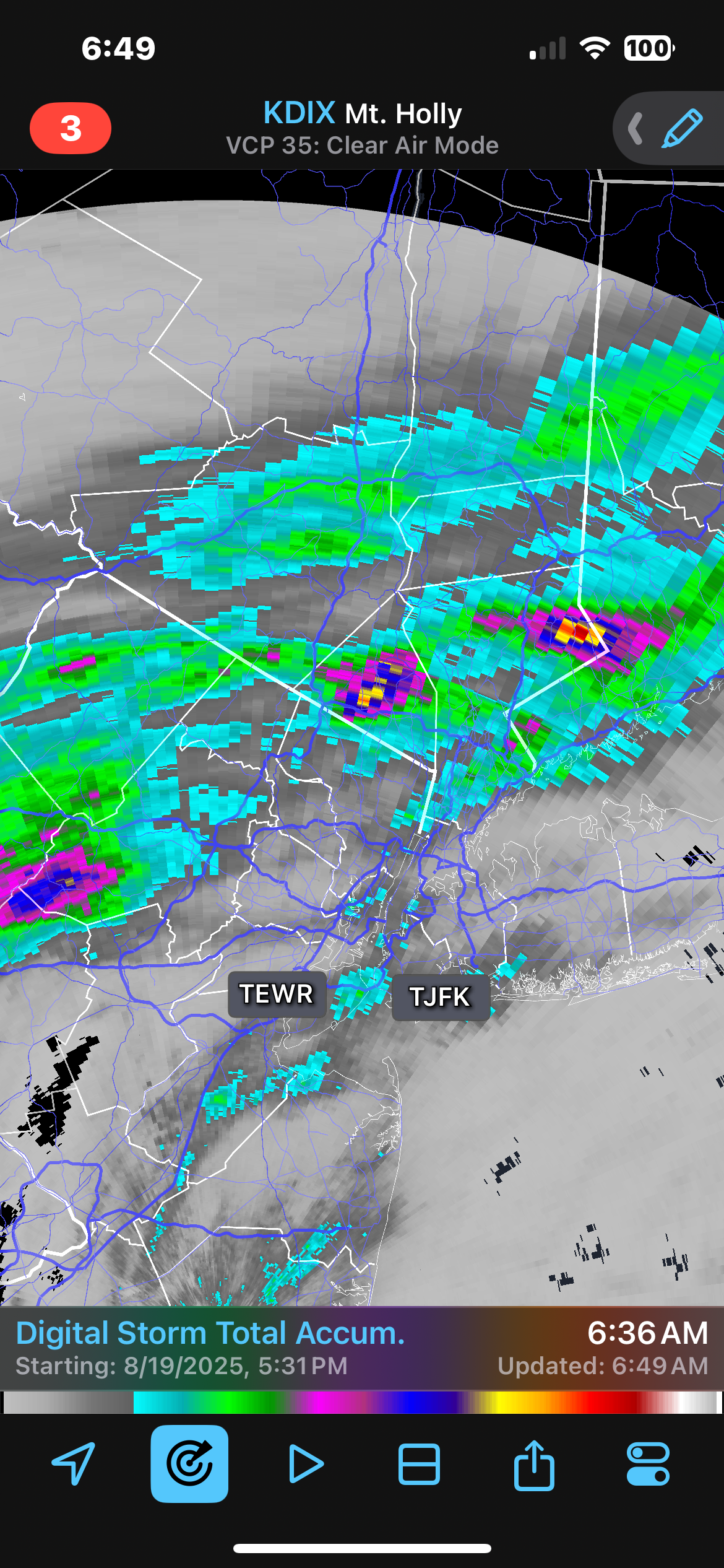
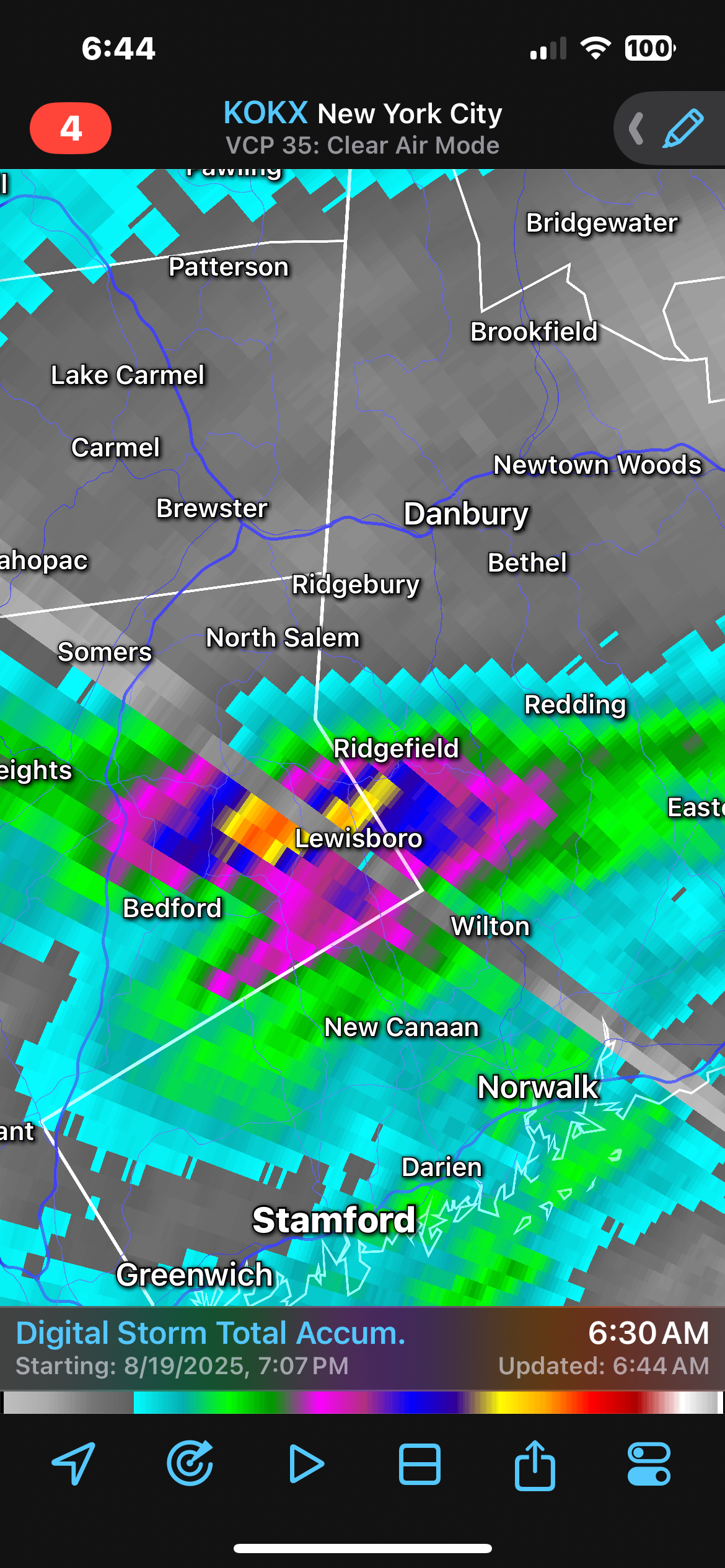
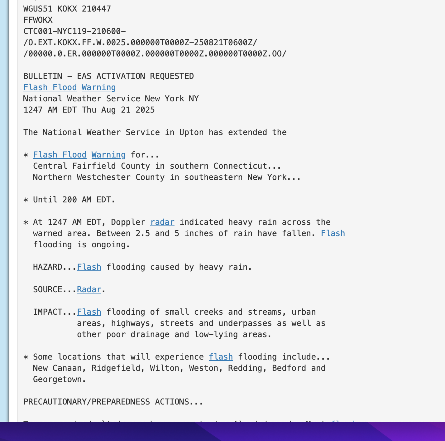
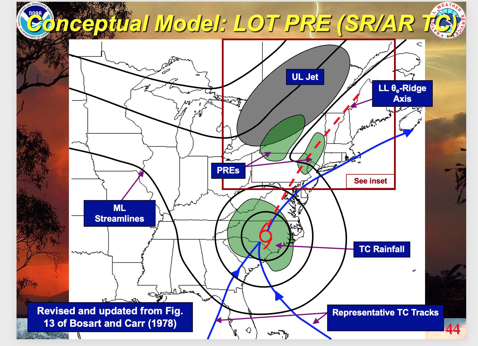
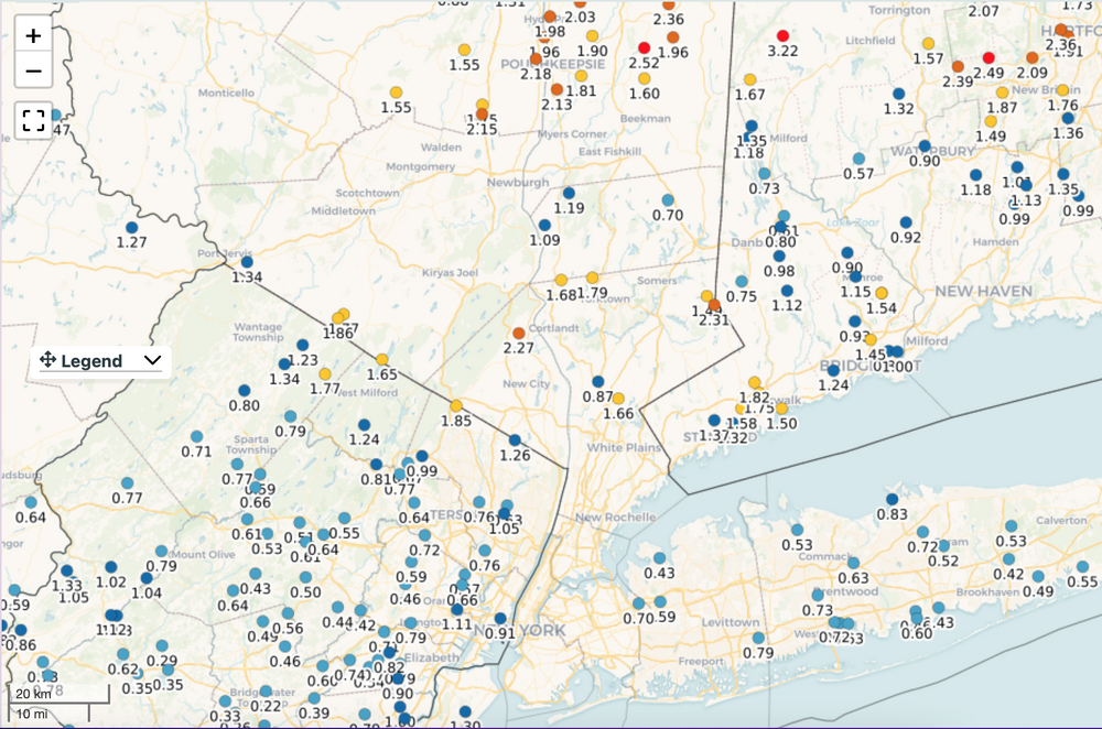
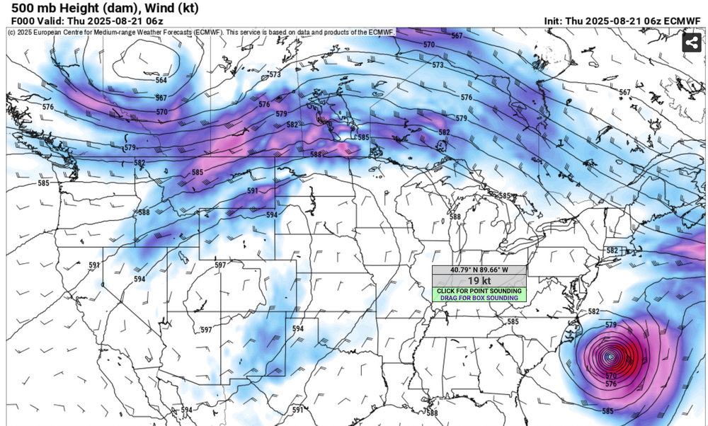
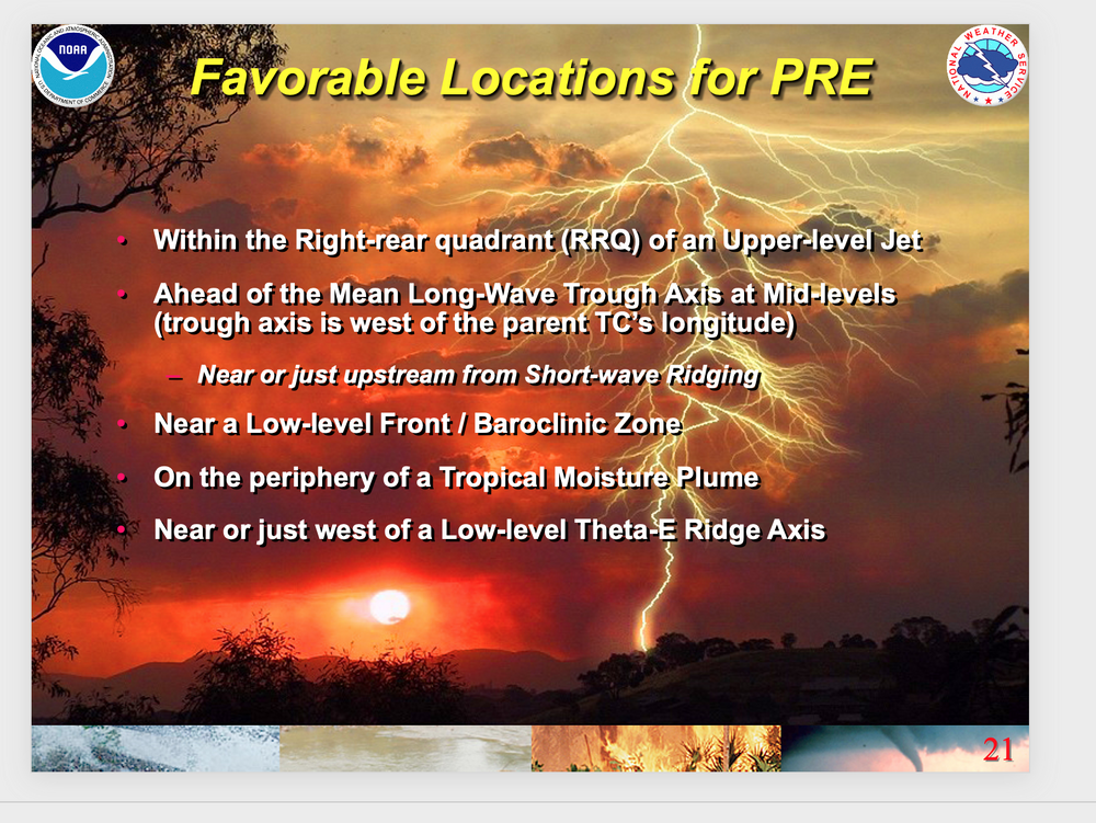
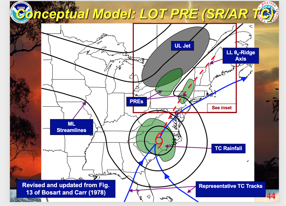
 Kind of embarrassing for the GEFS/CMCE early Monday morning guidance that was relied upon for the WPC dry product for Wednesday 8/21. Our p45 815AM post had it all documented, with the EPS suite clearly indicating something along the lines of what happened. It's not always EPS/EC superior to the GFS suite but I am getting disappointed. Had this been winter, I think the forum would have been lit with posts. As it was, this snuck by... possibly most not caring, despite science allowing for consideration. No doubt the was a meaningful rain for all of us, alleviating some of the recent summer dryness. The rainfall accumulation graphics attached demonstrate. Also, while not a clear cut PRE, this qpf event was well in advance of Erin-an indirect influence on what happened here as you well know from watching radar. The PRE composite was helpful for me as meteorologist, attempting to gauge what might happen in our NYC subforum. MESOSCALE excesses: DID happen in se NYS and se CT, per attached NYC FFW, attached digital rainfall output which showed the 5" max, AND, weather underground two day report of 4.89" near Boutonville NYS (Old Post Rd) via station KNYSOUTH137. I did not check many stations there but you can get the drift. I have to clear some attachments so the attachments will complete at 915A and the attached at 915AM may not be in correct order, but if you're interested check all of this information presented. My house in Wantage NJ only 1.04 11A/20-6A/21.


-

Hurricane Erin: 110 MPH - 943 mb - N @ 13
GaWx replied to BarryStantonGBP's topic in Tropical Headquarters
The Outer Banks had sustained TS force winds overnight through 8AM despite the center being 200 miles to the SE/ESE/E! 1. From 2AM NHC advisory: “A sustained wind of 40 mph (65 km/h) and a gust to 46 mph (74 km/h) were recently reported at the U.S. Coast Guard Station Hatteras.” 2. From 5AM NHC advisory: “A WeatherFlow station at Jennette's Pier in Nags Head, North Carolina, recently measured a sustained wind of 41 mph (67 km/h) and a gust to 49 mph (80 km/h).” 3. From 8AM NHC advisory: “A WeatherFlow station at Jennette's Pier in Nags Head, North Carolina, recently measured a sustained wind of 45 mph (72 km/h) and a gust to 54 mph (87 km/h).” -
Can you just imagine when the next REAL SIGNIFICANT threat comes along. They will be tripping over the hyperbole. Just picture what it would be like if something like a Donna or 1944 came along. Mr. Ed from NJ will be leading the charge with daily news conferences 7 days before and 2 weeks after. The smart people hate the media and those that don't fall for all the hype. Hook, line and sinker every single time. I'll add....the only "hype" that was really needed was the message about rip currents, waves and surf to keep the truly stupid out of the water.
-
Some light showers are possible this morning part otherwise cloudy, and another below normal temperature day across the area. We clear up both tomorrow and Saturday before shower chances increase on Sunday. Some valley locations may reach the low 80's tomorrow and Saturday. After that we will not touch 80 degrees for the remainder of August as we have much cooler weather moving next week. Some valley locations may even reach the 40's for overnight lows next week. Some great autumnal like weather on the way. Our next rain chances are Sunday.
-
If this verifies, we'll have a pretty cool August. Most of the NWS stations are listing at least -2 avg temp deviation for the month so far. (e.g. KNAK -2.4; DCA -2.8)
-

Occasional Thoughts on Climate Change
donsutherland1 replied to donsutherland1's topic in Climate Change
Phoenix has a five-year master plan for expanding trees/shade. The City is aware of the growing risks its people face from increasingly frequent and intense heat. https://www.phoenix.gov/content/dam/phoenix/heatsite/documents/ShadePhoenixPlan_Nov13CouncilDraft_topost_EN.pdf -

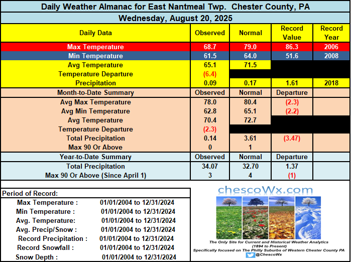
E PA/NJ/DE Summer 2025 Obs/Discussion
ChescoWx replied to Hurricane Agnes's topic in Philadelphia Region
Some light showers are possible this morning part otherwise cloudy, and another below normal temperature day across the area. We clear up both tomorrow and Saturday before shower chances increase on Sunday. Some valley locations may reach the low 80's tomorrow and Saturday. After that we will not touch 80 degrees for the remainder of August as we have much cooler weather moving next week. Some valley locations may even reach the 40's for overnight lows next week. Some great autumnal like weather on the way. Our next rain chances are Sunday.
-
ANOTHER LEMON SLOP AOI (30/30)
BarryStantonGBP replied to BarryStantonGBP's topic in Tropical Headquarters


.png.5f608e41049c1cc65a4d1188e0ea5b58.png)