FallsLake
-
Posts
6,318 -
Joined
-
Last visited
About FallsLake

- Birthday 11/14/1965
Recent Profile Visitors
7,545 profile views


-
I am really sorry to hear this. I met him once at a SE weather meeting. He was a really nice person. It would be great to get a big snow this year in his memory.
-
The “is it ever going to snow again” discussion.
FallsLake replied to psuhoffman's topic in Mid Atlantic
My wife inherited a home in Boone. We're starting to remodel it. Couple of weekends back we were up there and took the kids sledding up on Beech Mountain. Had to go through Banner Elk and there was 4-5" of snow on the ground. Once we got up to Beech it was close to 10". Winds were gusting over 30 mph and the temp was 17. True blizzard. Elevation really makes a difference. -
Yep, that low is giving us unusually cool temps and blocking the warmth to our west. May can be a funny month; it can be cool/cold or summer hot. I prefer the cool/cold for right now. As we all know, summer hot will take over for good in the upcoming weeks.
-
Yeah the northwest is a crazy place (talking weather). For places like Portland and Seattle 90% of the summer doesn't require AC; but when you do need it, you really need it.
-
That was a fun storm for everybody north and west of Raleigh. I remember sweating the transition line as it wavered back and forth in southern Wake county. Hopefully this next storm trends just a little colder putting more in play. Many model runs from now to "go time".
-
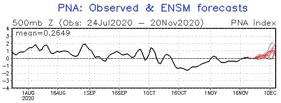
Yeah, the PNA is crucial for us. It looks to go positive in the LR. Hopefully we can get it to stay positive for an extended period.
-
The pattern is totally opposite of where we want to be. NAO and AO is positive, and PNA is negative. I'm with you guys in preferring to see this pattern now and not in four or six weeks. I'm in the mindset that what goes up must eventually come down (indices wise).
-
The humidity will come up early next week, but yeah the real bad heat seems to stay away. We'll have to wait about a week to see if the next cold front can make its way through. I for one am tired of the heat/humidity.
-
Hey Mack, You know the upstate will now get an epic two footer this winter.
-
I did two years as well (Bitburg AB - near Luxembourg boarder). Saw one good snow, and then afterwards the storms reminded me of NC winter storms; all mixed bag events. But as you stated, the cool summers were very nice. Our barracks didn't have AC and there were only a few days a years were it got really hot.
-
Happy Easter Everybody! Looking ahead into next week, we could see another chance of frost and a day that stays in the 40s. We all know the days of heat and humidity are getting closer. Cherish any cool/cold weather we can get now. <from RAH> High temps on Tuesday are expected to range from the mid 60s north to the mid 70s south, with lows on Wednesday morning in the 40s to lower 50s. Highs on Wednesday, which will be greatly affected by the precip and may not occur until very late in the day are expected to be in the lower to mid 50s, with perhaps a few upper 50s across southern portions of the area. However, we could see temps remain/drop in the 40s across a good portion of the day across the Piedmont and northern and central Coastal Plain. Wednesday night through Saturday: Cool high pressure will build into and across the area Wednesday night through Friday. This will result in cool temps for mid April, with below normal temps through Friday morning. Expect high temps on Thursday in the lower to mid 60s. High temps on Friday should rebound to near normal, as the surface high shifts to the east and a warming return flow returns. Thus expect highs in the upper 60s to lower 70s. Morning low are expected to range from 35-40 on Thursday morning and in the upper 30s to lower 40s for Friday morning. Thus, we may have the potential for some frost again across portions of the area late week.
-
RAH is staying cautious, but mentioning the possibility of some light snow (especially for folks down east): Temperatures should remain nearly stationary on Thursday with only a few degrees of warming possible thanks to the presence of plentiful clouds and consistent CAA downsloping surface flow. Strong 1045mb Canadian surface high pressure will continue to settle southeast, helping to drive a secondary surge of cooler and drier air into central NC during the late afternoon and evening hours. This continues to occur in conjunction with a re-resurgence of mid to upper-level moisture in response to a developing coastal low out ahead of an approaching mid-level shortwave. The 00z ECMWF and its ensemble members, which have tended to remain the less excited solutions of its sister models in past runs, have come into better agreement with the run to run consistent GFS/GEFS and CMC. Now, just about all synoptic models at least hint at the possibility for a few snow flakes at the back edge of the system. With the 00z suite, models have trended to show a stronger and geographically closer coastal cyclone development Thursday evening at the leading edge of the mid-level trough, allowing for a greater draw of Atlantic moisture inland while also increasing the cold air entrainment processes into central NC from the NW. As a result, the chances of some low to no impact snow flurries have increased a bit, ironically mainly in the non-climatologically favored areas along and east of the interstate 95 corridor. Even with the most recent increase in snow flurry possibilities, several limiting factors will need to be overcome to see even trace accumulations at the surface. This includes and is not limited to (1.) Overcoming above freezing surface/near surface temperatures; and (2.) Overcoming the dry air in place at the surface. As of now, even the cooler modele`s wet bulb temperatures remain above freezing across our forecast zones which increases our confidence in little to no accumulations likely. Still, can`t rule out some flakes able to fall through the mid-level dry layer to the surface, primarily during the 21z Thursday through 03z Friday time frame where moisture and cold air should meet up briefly. After 03z Friday, low and mid- level drying should become too much for the weakening upper-level saturation in the favored ice crystal growth zone to overcome as we progress further into the overnight hours. For now, have mentioned a few locations of no-accumulation -RA and/or -SN in the weather grids across the northeastern Piedmont and Coastal Plain during said time- frame to account for the threat.
-
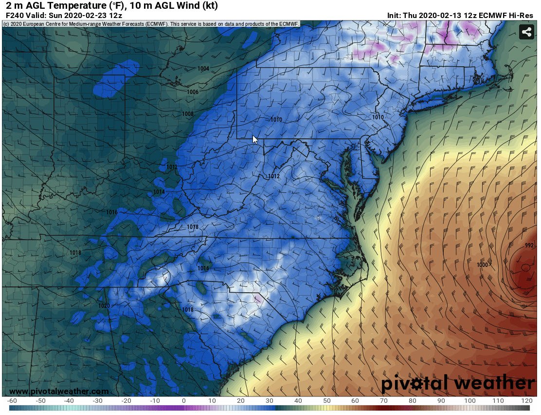
Can anybody tell where the euro thinks the snow cover will be?
-
I hear you. Part of my criteria for a good winter storm is how it affects the roads (or power lines). Years back we had a <1" (mid-day) event that stuck right to the roads and caused havoc. I consider that a great event. Other times we received >3" but it never stuck to the roads (forgettable).
-
Yep, it will be interesting (in a bad way) to see if we get blanked. **only thing I keep thinking about is with a warm winter, do we flip to a cold spring. If so, we could score an overnight event in March that at least gives an accumulating event.