All Activity
- Past hour
-

White Christmas Miracle? December 23-24th
CoastalWx replied to Baroclinic Zone's topic in New England
I would like to see continued improvement on guidance and not a LBSW thing today. 6z moved towards it. -

White Christmas Miracle? December 23-24th
Ginx snewx replied to Baroclinic Zone's topic in New England
I remember when people complained about the Juju word back on Eastern. Lol There was no Grinch storm instead its a Christmas miracle. Festivus for the rest of us. -

December 2025 Short/Medium Range Forecast Thread
Holston_River_Rambler replied to John1122's topic in Tennessee Valley
Wonder which PV he's talking about in the above? Stratospheric or tropospheric? #PolarVortex doesn't make it clear. It's almost as if he's looking for clicks or something. A strengthening -NAO can put pressure on the SPV and the TPV. Example from 0z Euro: I chose 30mb because that pressure level is lower and closer to where the potential -NAO is forming. The same processes that are helping to create the -NAO on the recent deterministic runs are also fluxing heat poleward at the tropopause. 500mb: Tropopause: Pac jet doesn't look terrible to me in deterministic progs. Right now, yeah, that's not good: We never really want to see it all the way across the Pac. But going forward, looks buckly to me. Of course that and anything can and will change. I'm encouraged this AM by the OPs finding the -NAO again and that wavy pac jet look. I seen years where that jet was just a fire hose all the way across the Pac in to California. -
Great composition and depth of field!
-
Yeah I just took a look at the guidance and consensus is growing on a nice 2-4” event. And since it will be cold enough afterwards, that means we’d get a White Christmas.
-

White Christmas Miracle? December 23-24th
WinterWolf replied to Baroclinic Zone's topic in New England
You have “If bringing my juju back”…I think you mean “I’m” bringing my juju back…right? Correct that so the snow gods don’t punish us for poor grammar..please -
"the year"? As in it only happened once?
-
White Christmas Miracle? December 23-24th
Ginx snewx replied to Baroclinic Zone's topic in New England
Its beginning to look alot like Christmas Congrats Jeffafafafa to Dendrite and everyone else.png.8bcb600df88e49684f2249371adf635e.png)
.png.1235c6ce0f668ad356c83f6bfd431057.png)
-

Central PA Winter 25/26 Discussion and Obs
Mount Joy Snowman replied to MAG5035's topic in Upstate New York/Pennsylvania
Low of 23. Total rainfall was .54”. Have to host a big family gathering today. Lots of work to do this morning. Enjoy the weekend everyone! -
Sweet look for here. GFS works too. Just like the troughs I used to know.
-

December 2025 regional war/obs/disco thread
Baroclinic Zone replied to Torch Tiger's topic in New England
LFG! -
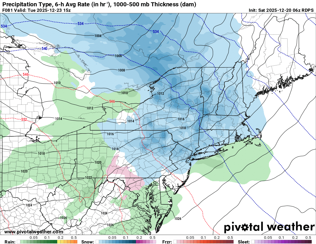
If bringing my juju back for this one. Let’s talk about the shortwave traversing across the northern tier states and crossing the area on the 23rd. High pressure is overhead and we have a fresh antecedent airmass cold enough to support frozen precip. High pressure pushes south and we get that moist southerly return air just as system is moving in. Potential is there for advisory level snows for a broad area. Also seeing some potential for redevelopment or inverted trough as system pushes offshore.
-

December 2025 regional war/obs/disco thread
SouthCoastMA replied to Torch Tiger's topic in New England
clips the ema coast Christmas eve morning. It sort of looks like the trough on 12/14, but more pronounced. something to watch at least -

Central PA Winter 25/26 Discussion and Obs
pawatch replied to MAG5035's topic in Upstate New York/Pennsylvania
My power went out 3 times, but was back on within 5 minutes. Some other people were less fortunate. We had 53 mph wind gust and a 1/4” of rain dumped on us in less than a couple minutes. Crazy weather. -
Do you still have anything on the ground up there? Surprisingly didn't loose everything here... but most, probably 20 percent coverage
-
Remember the year with lots of snow on the ground until the 23 and gone by xmas? That was the ultimate kick in the balls. Lots of ice on the roads 31F
-

December 2025 Short/Medium Range Forecast Thread
*Flash* replied to John1122's topic in Tennessee Valley
Curious...has our area ever done well with a strong PV before? Seems the -NAO may not be enough based on what JC is suggesting here...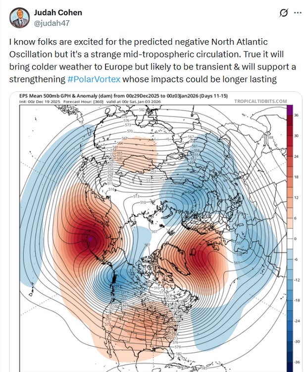
- Today
-

Possible Light Snowfall (1" - 3") on Tuesday Dec 23
MJO812 replied to Northof78's topic in New York City Metro
I think the snow sticks on colder surfaces for the city unless the precip rushes in faster than modeled. -

December 2025 Short/Medium Range Forecast Thread
Carvers Gap replied to John1122's topic in Tennessee Valley
Some good runs overnight. The ensemble means are washed out at range which is understandable, but their individual members have it. There are 4-5 warm scenarios per suite which are skewing the greater number of cold members. We saw the same things happened with recent cold fronts....ensembles couldn't see them in the mean. The deterministic runs of the Euro, GFS(6z and 12z), and CMC have strong NAO solutions - some extreme which I doubt verify. That said...any model without the NAO right now can't be discounted, but the ones with it....are more likely to have correct solutions. -

Possible Light Snowfall (1" - 3") on Tuesday Dec 23
Northof78 replied to Northof78's topic in New York City Metro
6z GFS ups the ante, more moisture and a more robust system seems to be the trend. 2-4" for much of the forum -
Possible Light Snowfall (1" - 3") on Tuesday Dec 23
MJO812 replied to Northof78's topic in New York City Metro
Here is the rgem
.thumb.png.e63bb008cc03a1d5dcb3022d0a978606.png)
-
6z euro more with the inv trough look into srn Me and central NH.
-

Central PA Winter 25/26 Discussion and Obs
canderson replied to MAG5035's topic in Upstate New York/Pennsylvania
Found my downspout extenders. The wind took both off the end of my downspouts and blown them across the street into a field. -

Central PA Winter 25/26 Discussion and Obs
mahantango#1 replied to MAG5035's topic in Upstate New York/Pennsylvania
Still over 16,000 customers of PPL without power this morning. 17 this morning. -
The redevelopment on the AI models is nice to see. Would keep flow from ripping out of the SW at 850 and below. Seems like op runs so far are slowly migrating to that idea.


.png.326ab1d3ce6ebee511a4bf334f4cf125.png)
