All Activity
- Past hour
-

Occasional Thoughts on Climate Change
LibertyBell replied to donsutherland1's topic in Climate Change
Western Europe is warming like Western North America is warming, does having an ocean west of you increase the rate of warming? And why? One would think the opposite should be true (since the main flow of air is west to east.) -

September 2025 OBS-Discussion centered NYC subforum
winterwx21 replied to wdrag's topic in New York City Metro
I just had a little 3 minute shower here that was barely enough to wet the ground. I agree it's unlikely that we're gonna get much, but we'll have to see if we can get lucky with one of these isolated downpours. I see there's one down in Monmouth right now heading northwest, but I don't know if it's gonna hit us or miss a little to the south. -
Occasional Thoughts on Climate Change
LibertyBell replied to donsutherland1's topic in Climate Change
wait why would ANYONE have an opposition to air conditioning? -
1.48" for the event. Didn't expect a soaker like this but I can't say I have been paying close attention in the days leading up.
-
Was 64 and partly suny here in Copenhagen today. Will actually be 70 this weekend.
-
Yawn worthy weather continues here, for the next seven days at least as forecast by NWS for Chicopee, Mass. (local station). Meanwhile, my theme song for the summer:
-
Definitely a mess, sheared apart by an ULL. blob:https://www.tropicaltidbits.com/5026dd98-4087-4470-abf3-c589c2404393 Plus surrounded by dry sinking air.
-
Not for folks old enough to remember the mid-1960s. (But more than enough - time for some rain.)
-
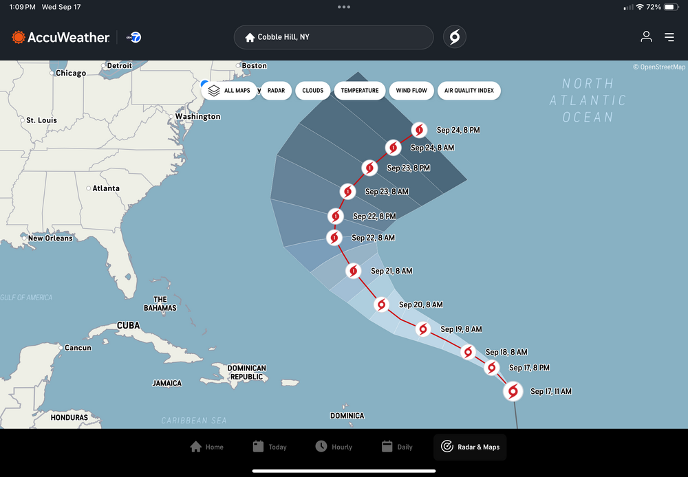
12Z summary of main ops-Icon H 250 miles E/SE of Bermuda 9/22-3-GFS another relatively weak run with a TS over Bermuda but takes 10 days (9/27)!-CMC H 150 miles E/SE of Bermuda 9/22-Euro H 200 miles E/SE of Bermuda 9/22-JMA out to only 72 as a TD recurving-UKMET: TS ~150 miles E of Bermuda 9/22:NEW TROPICAL CYCLONE FORECAST TO DEVELOP AFTER 24 HOURSFORECAST POSITION AT T+ 24 : 20.0N 50.9WLEAD CENTRAL MAXIMUM WINDVERIFYING TIME TIME POSITION PRESSURE (MB) SPEED (KNOTS)-------------- ---- -------- ------------- -------------1200UTC 18.09.2025 24 20.0N 50.9W 1009 350000UTC 19.09.2025 36 20.8N 53.2W 1009 311200UTC 19.09.2025 48 21.3N 55.3W 1010 290000UTC 20.09.2025 60 22.4N 58.1W 1011 301200UTC 20.09.2025 72 23.6N 59.5W 1011 270000UTC 21.09.2025 84 25.1N 61.1W 1011 291200UTC 21.09.2025 96 26.9N 61.2W 1011 330000UTC 22.09.2025 108 29.3N 62.0W 1008 431200UTC 22.09.2025 120 31.2N 62.2W 1007 470000UTC 23.09.2025 132 33.5N 61.9W 1005 411200UTC 23.09.2025 144 36.5N 58.5W 1003 420000UTC 24.09.2025 156 39.5N 52.7W 994 431200UTC 24.09.2025 168 42.3N 44.3W 982 52
-
sorry folks.
-
Wrong place @Wxtrix
-
You realize the population of Bermuda is WELL below 100K never mind MILLIONS. The article is pure clickbait.
-
Looks like another batch might be getting reeled in by the Frederick precipitation vacuum.
-
The 30mb QBO has fallen to -22.28 and still dropping. I think it levels off(hits the bottom of the parabola) sometime during December or January. That likely promotes chances for some HL blocking episodes. I don't see that in modeling yet, but that is more of a mid-Nov to late Dec thought anyway.
-

September 2025 OBS-Discussion centered NYC subforum
Neblizzard replied to wdrag's topic in New York City Metro
Pouring in Union County NJ. This event is sure localized but I’ll take it. -
"blizzard watch" is all I needed to see lol
-
i can't remember the last time it rained for so long. it's wonderful. all the local wx stations are reporting an inch of rain, more or less.
-

September 2025 OBS-Discussion centered NYC subforum
SACRUS replied to wdrag's topic in New York City Metro
-
.53" last 24 hrs................ So good to see rain at last! The most from one event since July 31.
-
 Torch Tiger changed their profile photo
 -

-
Followup: JB was surprisingly quiet. All he said was this: “Now, the red-hatched area has been designated Tropical Depression 7, posing a threat to Bermuda but not the U.S.” But then he immediately mentioned a possible unexpected “side-show Bob” to form off the SE US.
-
Daily mail loves click bait. That is a whopper tale they are spinning for those clicks.
-
I love the “battle-zone” that so many forecasters love to put much of the SE US in every winter lol.
-
Absolutely right with the Bermuda comment. Stay well, as always.
-

2025-2026 ENSO
soadforecasterx replied to 40/70 Benchmark's topic in Weather Forecasting and Discussion


