All Activity
- Past hour
-

12/3 Snow/Sleet/Mix Bag of Everything Discussion/OBS
Hurricane Agnes replied to Mikeymac5306's topic in Philadelphia Region
7z NBM for snow and ice. Probably gonna be some crust on snow and/or ice coatings, depending on the air temps as the changeover happens further north.

-

First Winter Storm to kickoff 2025-26 Winter season
CoastalWx replied to Baroclinic Zone's topic in New England
OMFG. Shoot whoever said that, to the sun. -

First Winter Storm to kickoff 2025-26 Winter season
40/70 Benchmark replied to Baroclinic Zone's topic in New England
Jesus...between winter solstice sun angle trepidation and 2-11" ranges WTF is going on at BOX? Did they put @Snowcrazed71in charge? -
Records: Highs: EWR: 72 (2006) NYC: 70 (2006) LGA: 71 (2006) JFK: 68 (2001) Lows: EWR: 15 (1976) NYC: 8 (1875) LGA: 19 (1976) JFK: 18 (1967) Historical: 1831 - The coldest December of record in the northeastern U.S. commenced. Temperatures in New York City averaged 22 degrees, with just four days above freezing, and at Burlington VT the temperature never did get above freezing. The Erie Canal was closed the first day of December, and remained closed the entire month. (David Ludlum) 1896 - The temperature at Kipp, MT, rose 30 degrees in just seven minutes, and 80 degrees in a matter of a few hours. A thirty-inch snow cover was melted in half a day. (The Weather Channel) 1913 - A six day front range snowstorm began. It produced a record total of 46 inches at Denver CO. (David Ludlum) 1925: An extremely rare late November hurricane began to affect the west coast of Florida as it strengthened during the day. The storm made landfall very early on this date south of Tampa Bay, weakened to a tropical storm as it crossed central Florida, and exited around St. Augustine. The storm regained Hurricane strength off Jacksonville later in the day. Heavy rain continued over northeast Florida on the 2nd. Gale force winds were reported from the Keys to Jacksonville and over 50 people lost their lives, mostly on ships at sea. Damage along the coast south of Jacksonville was heavy and excessive rain and wind seriously damaged citrus and truck crops. (Ref. Wilson Wx. History) 1962: An upper level ridge over the Ohio Valley brought record high temperatures from the northern Plains, Midwest to the Ohio Valley and New York. The following locations reported their warmest December temperatures: Hatfield, WI: 64 °F, Decorah, IA: 63 °F and Charles City, IA: 62 °F. See other daily record high temperatures for the date included on reference link: (Ref. Wilson Wx. History) 1964: On this date through the 2nd, a severe windstorm hit the Canadian Maritimes packing winds gusting to 100 mph. Three fishing vessels and 23 lives were lost. Total damage due to high seas, wind and flooding was estimated at over $1 million dollars. (Ref. Wilson Wx. History) 1966: (1st-2nd) Helped by a Lake Erie temperature of 45 degrees, lake-effect snows deposited 55 inches in Mayville and 60 inches in Copenhagen, NY. Amazing snowfall rates on 2nd in Copenhagen: 6 inches/hour for 30 minutes, then 12 inches/hour between 2-3 p.m. today. Visibility reduced to 50 feet. (Ref. Weather Guide Calendar with Phenomenal Weather Events 2011 Accord Pub. 2010, USA) 1970: Four tornadoes impacted east-central Wisconsin during the morning hours. The strongest tornado, an F3, formed at 10:15 AM near Medina in Outagamie County. The twister moved northeast at 50 mph and destroyed twenty barns and five houses. 1978: A small tornado cut a path 6 miles long near Zephyrhills, FL. Three mobile homes were destroyed and 17 others were damaged. Five brooder houses were also destroyed, resulting in the death of about 3,000 chickens. A powerful winter storm began to produce heavy snows across mainly the Nebraska panhandle. By the time it ended the next day, Bridgeport, NE reported 15 inches and Scottsbluff, NE reported 11.5 inches. (Ref. AccWeather Weather History) 1982: 6.6 Inches snow in Washington, DC is only above average snow for December in the last 12 years. (Ref. Washington Weather Records KDCA) 1985 - A storm produced more than six inches of snow from the Northern and Central Plains to parts of Michigan, with 36.4 inches reported at Marquette MI. Many roads were blocked by snow. A family was stranded for 25 hours south of Colome SD. Drifts twelve feet high were reported in north central Nebraska. (The Weather Channel) 1987 - A powerful storm hit the northwestern U.S. Winds gusted to 80 mph at Cape Disappointment WA, and reached 94 mph at Cape Blanco OR. Thunderstorms in western Washington State produced wind gusts to 60 mph, and dime size hail at Hoquiam. Stevens Pass, in the Cascade Mountains of Washington, received seven inches of snow during the morning hours. (The National Weather Summary) (Storm Data) 1988 - Squalls in the Great Lakes Region produced up to a foot of snow in Ashtabula County OH, up to ten inches in Erie County PA, and up to a foot of snow in western New York State. (Storm Data) (The National Weather Summary) 1989 - Heavy snow blanketed the mountains of New Mexico, with 12 inches reported at the Angel Fire Ski Basin. Strong northerly winds ushering cold air into the north central U.S. gusted to 55 mph at Devils Lake ND. Low pressure over the Gulf of Alaska produced wind gusts to 69 mph at Kodiak Island. (Storm Data) (The National Weather Summary) 2002 - Heavy lake effect snow fell downwind of the U.S. Great Lakes. Buffalo, New York reported 16 inches of snow, with thundersnow reported late in the afternoon. While the eastern U.S. experienced much colder than normal temperatures on December 1, much of Alaska was basking in above average warmth. Many daily temperature records were set across this region through the beginning of the month. 2006: A winter storm produced more than 6 inches of snow along a 1,000-mile-long path from central Oklahoma to northern Michigan from November 30-December 1st. The storm also produced significant freezing rain, which impacted the St. Louis area. An estimated 500 or more homes and businesses were without power in the St. Louis area after this storm. 2007 - During December 1-3, a powerful storm with hurricane force winds struck the Northwest U.S. The storm brought heavy rain and wind gusts over 100 mph, with the highest reading being 129 mph at Bay City, OR. The strong winds brought power lines down, and the heavy rain caused widespread flooding and triggered landslides (BBC News). According to reports, 8 fatalities were attributed to the storm and about 37,000 homes and businesses were left without power in Washington, Oregon, and northern California. President Bush declared a federal disaster in several counties in Washington and Oregon to provide recovery assistance (Associated Press). 2011 - Wind speeds as high as 102 MPH were measured in Centerville, Utah and surrounding cities. Damage was reported throughout Weber and Davis counties ranging from South Ogden down to Bountiful. More than 400 trees were down at the Davis Golf course alone due to the winds. Up to 54,000 residences were without power throughout the day and into the evening. Train service between Layton and Salt Lake City was suspended due to damaged train stations, debris on the train tracks, and power outages. Cleanup costs totaled $8 million in Centerville alone. No injuries were reported from the wind, but a number of injuries were reported from those helping with the cleanup effort.
-

First Winter Storm to kickoff 2025-26 Winter season
ORH_wxman replied to Baroclinic Zone's topic in New England
December sun angle will get you every time. -
WB 12Z HRRR: snow moves in between 5-6am for NW zones. All rain east of the mountains by 11am.


-
Short range and medium range rug pulls in the same model cycles. Mid season form on December 1st!!
-

First Winter Storm to kickoff 2025-26 Winter season
ariof replied to Baroclinic Zone's topic in New England
From the BOX AFD: The timing of this system (largely during the day) doesn`t bode well for snow chances in the low elevations. I guess they're looking only at the time of day and not, like, the time of year? -
Are you from the future!?!
-
First Winter Storm to kickoff 2025-26 Winter season
40/70 Benchmark replied to Baroclinic Zone's topic in New England
I thought it would get a bit further....may shift that jack se a bit. -
37 / 24 mainly clear. Dec opening cold and continuing at least the first 7 - 10 days. Overall colder to much below normal through the 11th (at least). Trough into the east with deeper cold Dec 4 - 9th. Perhaps one sub freezing day even to the coast on Fri/Sat. Would be surprised to not get above normal Dec snowfall this month.
-
 I will add my 2 cents on this topic. As it looks now this event looks questionable to attain a NESIS rating. Do we want to consider that as a possible parameter for events of this type going forward?
 -
First Winter Storm to kickoff 2025-26 Winter season
ORH_wxman replied to Baroclinic Zone's topic in New England
06z GFS had it pinned in roughly the same spot too. But this is a situation where like 10 miles could be the difference between 10" of cement and 2" of slop. -
First Winter Storm to kickoff 2025-26 Winter season
KTBFFH1905 replied to Baroclinic Zone's topic in New England
Hoping for at least 3-6 for us here in Avon. -
Picked up 2.5" last night... nice surprise.
-

Pittsburgh/Western PA WINTER ‘25/‘26
jwilson replied to Burghblizz's topic in Upstate New York/Pennsylvania
Tomorrow looks like a classic southern slider with just enough northern stream interaction to get us 2-3" and keep the rain at bay, except for those in the southernmost counties, of course. The warm tongue is undefeated. Not likely to find any big events in this pattern, but the next couple weeks look okay for those old-timey Alberta Clippers. I'm sure we'll take any snow while we can get it. It should make things look festive around these parts until the (perhaps brief) Christmas warmup. -

First Winter Storm to kickoff 2025-26 Winter season
Snowcrazed71 replied to Baroclinic Zone's topic in New England
Lol... Sorry to disappoint. I'm actually in Plainville which is just next to Farmington west of Hartford. All kidding aside, I thought The Nam was in range within 24 hours at the start of the storm. Not that I'm going with the NAM LOL. -
First Winter Storm to kickoff 2025-26 Winter season
CoastalWx replied to Baroclinic Zone's topic in New England
Either slush or the grid goes down in Holliston. -
(002).thumb.png.6e3d9d46bca5fe41aab7a74871dd8af8.png)
Central PA Fall Discussions and Obs
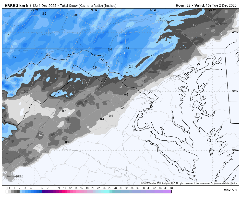
ChescoWx replied to ChescoWx's topic in Upstate New York/Pennsylvania
November finished as our 3rd below average temperature month over the last 4 months. December looks to also be getting off to a well below normal temperature start. Sunny today but with temperatures almost 10 degrees below normal for highs. Clouds roll in tonight with some snow arriving toward dawn. The Winter Weather Advisory starts at 4am for Western Chester County. Any snow to start should quickly change to sleet and then rain with little if any accumulation. That said with the timing near rush area it may be a bit slippery for the morning commute. High temperatures Tuesday through Thursday will be in the mid 30's well below average but fall even further below average by Friday as the coldest air of the season arrives. Temperatures on Friday will stay in the 20's. Another wintry event is possible by Friday night into Saturday.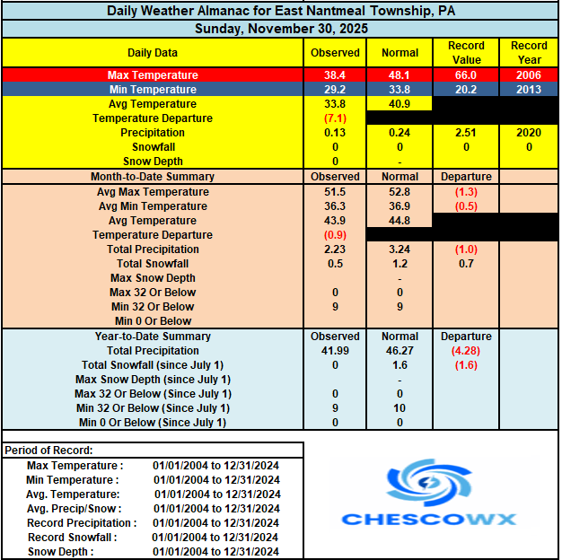
-

First Winter Storm to kickoff 2025-26 Winter season
HoarfrostHubb replied to Baroclinic Zone's topic in New England
Timing seems a little slower (for the outset in my area) -
E PA/NJ/DE Winter 2025-26 Obs/Discussion
ChescoWx replied to LVblizzard's topic in Philadelphia Region
November finished as our 3rd below average temperature month over the last 4 months. December looks to also be getting off to a well below normal temperature start. Sunny today but with temperatures almost 10 degrees below normal for highs. Clouds roll in tonight with some snow arriving toward dawn. The Winter Weather Advisory starts at 4am for Western Chester County. Any snow to start should quickly change to sleet and then rain with little if any accumulation. That said with the timing near rush area it may be a bit slippery for the morning commute. High temperatures Tuesday through Thursday will be in the mid 30's well below average but fall even further below average by Friday as the coldest air of the season arrives. Temperatures on Friday will stay in the 20's. Another wintry event is possible by Friday night into Saturday.
-
First Winter Storm to kickoff 2025-26 Winter season
CoastalWx replied to Baroclinic Zone's topic in New England
Yeah saw that. Certainly crushes you. -
 Personally, I think that there should be a headline. Even if NYC, its nearby suburbs, and Long Island won't be getting much, if any, snowfall, parts of the forum will.
 -
First Winter Storm to kickoff 2025-26 Winter season
CoastalWx replied to Baroclinic Zone's topic in New England
If you just showed me that low track, even this time of year would offer interesting weather. A shame the high retreats prior. -
First Winter Storm to kickoff 2025-26 Winter season
ORH_wxman replied to Baroclinic Zone's topic in New England
The really high resolution stuff (HRDPS/3k NAM/etc) overnight keeps the CF pretty far east. like near 128 or even slightly east (further north you go the further east it gets)....that's something to watch because it's likely going to stay snow on the cold side of that....usually there is some enhanced lower level lift on the left side of that CF which will help to cool that lower 900-950mb layer a little bit...which will obviously matter if we have temps near 0C in that layer.