All Activity
- Past hour
-
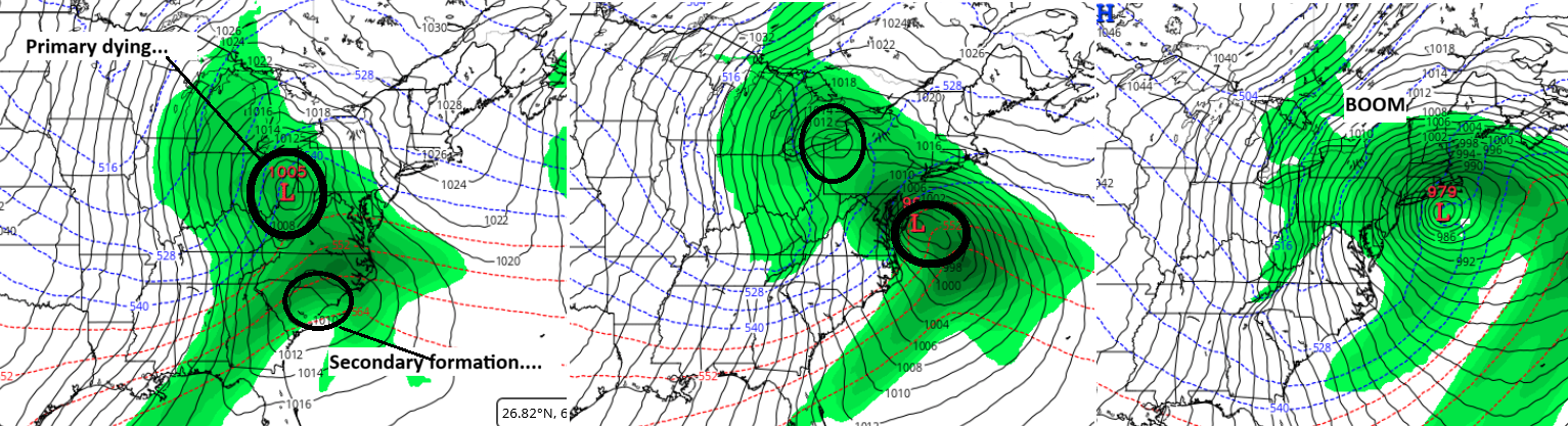
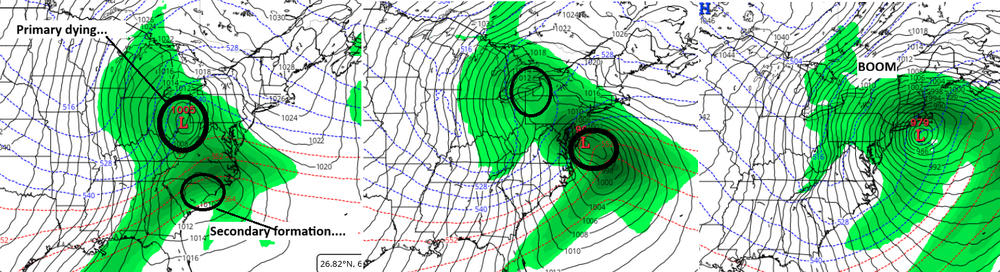
heh... yeah. That ukmet 00z run. Probably the fastest total tropospheric depth differential I've ever seen, certainly in that region. And it's not from a core arrival. It's cyclogenic feedback produced! It's imploding with the mid level height core just E of NJ a rate seldom seen - somewhere in the range of 30 dm in 12 hours. That's a hyperbomb
-
-

Late February/Early March 2026 Mid-Long Range
SomeguyfromTakomaPark replied to WxUSAF's topic in Mid Atlantic
I think if the Euro AI has the right idea (big if of course) we are going to have crashing 850s and really good ratios for the CCB. Surface temps will cooperate with that storm position in February. -

Late February/Early March 2026 Mid-Long Range
North Balti Zen replied to WxUSAF's topic in Mid Atlantic
Extreme Airplane voice: "Just want to tell you good luck, we are all counting on you" -
we’re gonna make our way back to that crawler along the New England coast and across the canal. It was there two days ago.
-

Is we back? February discussion thread
Damage In Tolland replied to mahk_webstah's topic in New England
Remember when forecasts had 50’s this week -
My experience....any snowfall in March is a complete surprise.
-
The leap from the 00z's AI ECM depiction to what it did in the 06z ... yee gads!
-
Holy hell what a foggy drive in to downtown Baltimore. Snowpack at the farm in Fallston similar to what mappy has in Parkton. Day 23 of at least one inch. Maybe the last day - I am guessing some will remain for tomorrow but we shall see.
-
Some flurries falling.
-
I hear 2023 and I’m triggered no matter what.
-

Is we back? February discussion thread
40/70 Benchmark replied to mahk_webstah's topic in New England
Funny how there is just a grave yard of Pacific disturbances amassing underneath that little block. -
If I recall correctly they didn't work out so well for February did they? I thought they were forecasting cold, not warmth.
-
Don’t sweat it yet
-
This WB 6Z Euro AI op run based on 10:1 has 19” at DC! Of course the 10:1 is way overdone because it has temps 33-35 for the first half of the storm. And the WB Euro AIFS has issues as many of us know with too high snowfall in general. However, the WB 0Z CMC and 6Z GFS do have a big hit per Kuchera of 9”! That’s probably a more realistic scenario for the upside potential imho. If DC were to get 9”, it would be their biggest since the 10.3” of 1/12-14/2019!
-
Is we back? February discussion thread
40/70 Benchmark replied to mahk_webstah's topic in New England
Yea, that's blatant plagiarism of the KU cookbook. -
Is we back? February discussion thread
40/70 Benchmark replied to mahk_webstah's topic in New England
This is why 2018 and 2023 are both valid analogs, despite each invoking drastically different reactions from CoastalWx!! -
Decent Miller B exemplified by the 06z AI GFS version... whether this happens or not, this is a run-way model
-
Even shows rain to start just south of NYC - what we don't want is this to track too close to the coast because the cold air is marginal - although a more intense system can create dynamic cooling - still early in the game so we will probably have to go through the model madness as usual.
-
Is we back? February discussion thread
40/70 Benchmark replied to mahk_webstah's topic in New England
Remember all year I was saying I think it will be like March 2023 with a little more help...case in point. While the pattern is redolent of that particular latter season stanza, the Pacific troughing is not quite as deleterious to winter prospects in this case because it's not as extreme and is accompanied by a favorable PV positioning. -
28° and light snow. Doesn't bode well for a torch day.
-
Latest Natty Blend looks solid. And posting snow maps is now somewhat useful as we are within a week and the preponderance of guidance indicates a legit threat.
-

Central PA Winter 25/26 Discussion and Obs
Mount Joy Snowman replied to MAG5035's topic in Upstate New York/Pennsylvania
Low of 34. Love hearing that the overnight runs moved in a positive direction. Seems like we’ll have a real storm to track. I mean, we’re basically only five days out already. Big runs the next 48 hours. -
Noticed that. Vortex to the north also expands and plays a role on whether or not we get Monday. But after Monday I think it may help keep the conus chinook away. I do think we’ll start to get warmer periods, but it also could be active so maybe we can squeeze in some winter weather.
-
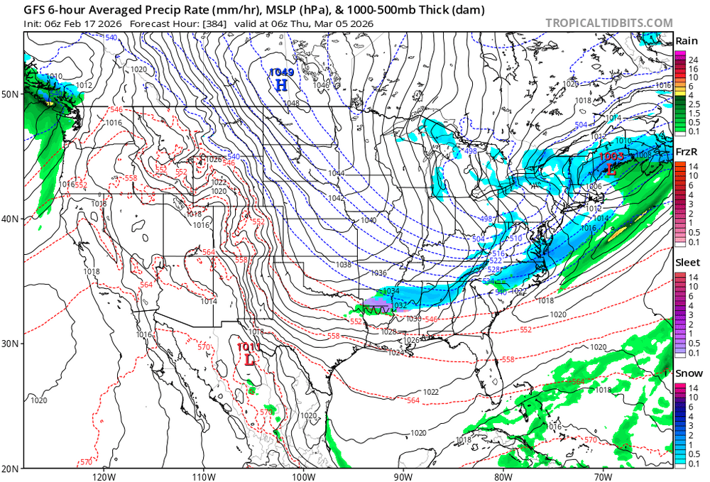
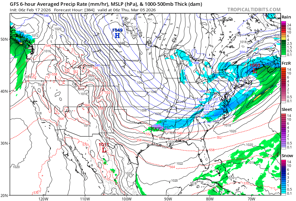
Oh hey hour 384 on the GFS bringing the goods to some lol. Funny yes, but may also be the last fantasy snow showing on models for the not mountains and Virginia north peeps for the season.