All Activity
- Past hour
-
64f. Feels like san diego Sent from my SM-S921U using Tapatalk
-

2026-2027 Record-breaking El Nino
snowman19 replied to Stormchaserchuck1's topic in Weather Forecasting and Discussion
Man, this upcoming WWB for early November looks real impressive on the models. This thing is the energizer bunny in regions 3.4, 3 and 1+2…. -

E PA/NJ/DE Autumn 2026 Obs/Discussion
The Iceman replied to PhiEaglesfan712's topic in Philadelphia Region
I'm far from a pro but the hobbyist in me thinks this winter is going to be a struggle. I think pac air will flood the continent and we struggle to get the cold air necessary for snow. I foresee a lot of cold rain. My guess for SE PA/NJ/DE would be 5 - 10" and most of that in one or two storms that either start as snow or end as snow. Super balls to the wall east based Nino rarely plays out well here. I hope I'm wrong but I'm heading into winter with measured expectations. Euro weeklies looked pretty bleak imo, storm tracks look underneath of us but the continent is flooded with warm pac air. Perfect track rainstorms may be the theme much like 97-98. I do think it'll be wet though so there's a chance snowfall could end up surprising like 2015-2016 if everything comes together in a favorable week or two period(cold air, blocking). I don't see a 6 week hard freeze like last year thats for sure... I think DJF temps averages +2 - +4, precip is above normal, snow below normal. I honestly just hope we don't get skunked again like 19-20 or 22-23. Temps: Dec +1 - +3 Jan +2 - + 4 Feb +3 - +5 Precip: Dec: Above average Jan: Average Feb: Above Average -

2026-2027 Record-breaking El Nino
SnowGoose69 replied to Stormchaserchuck1's topic in Weather Forecasting and Discussion
In recent weeks we have all seen those posts that most El Ninos in recent times the Nov pattern repeated in December...well yeah, probably not gonna happen this time. I'd be surprised if the +PNA/-AO/-NAO pattern dominated December in a +3 El Nino. Obviously the whole PV weakening is what will throw a wrench into the whole history but another case of I think nobody knows what will happen this winter. -
I think he means his grass
-

2026-2027 Record-breaking El Nino
Typhoon Tip replied to Stormchaserchuck1's topic in Weather Forecasting and Discussion
Yeah I'm liking this idea myself as of late. The 70 and 100 hPa level anomalies currently observed may be related. -

2026-2027 Record-breaking El Nino
roardog replied to Stormchaserchuck1's topic in Weather Forecasting and Discussion
I wonder if the recent big jump in Nino 4 anomalies and the +SOI is related. Could easterlies be pulling some of that warm water a little back to the west? -
2026-2027 Record-breaking El Nino
SnowGoose69 replied to Stormchaserchuck1's topic in Weather Forecasting and Discussion
You'd assume based on where the PDO is now and its tendency the last 2 winters from what it WAS on 11/1 to where it translated the remainder of the winter that probably is true. I don't see the PDO going from -0.7 to -1.6 when the last 2 winters in what was more a colder neutral setup it went towards neutral both times. -

2026-2027 Record-breaking El Nino
Terpeast replied to Stormchaserchuck1's topic in Weather Forecasting and Discussion
Another possibility is that the stronger mid latitude ridging (which also contributes to the NW Pac marine heat wave) is behind the strat warming. No science behind this, just speculation. -
2026-2027 Record-breaking El Nino
LakePaste25 replied to Stormchaserchuck1's topic in Weather Forecasting and Discussion
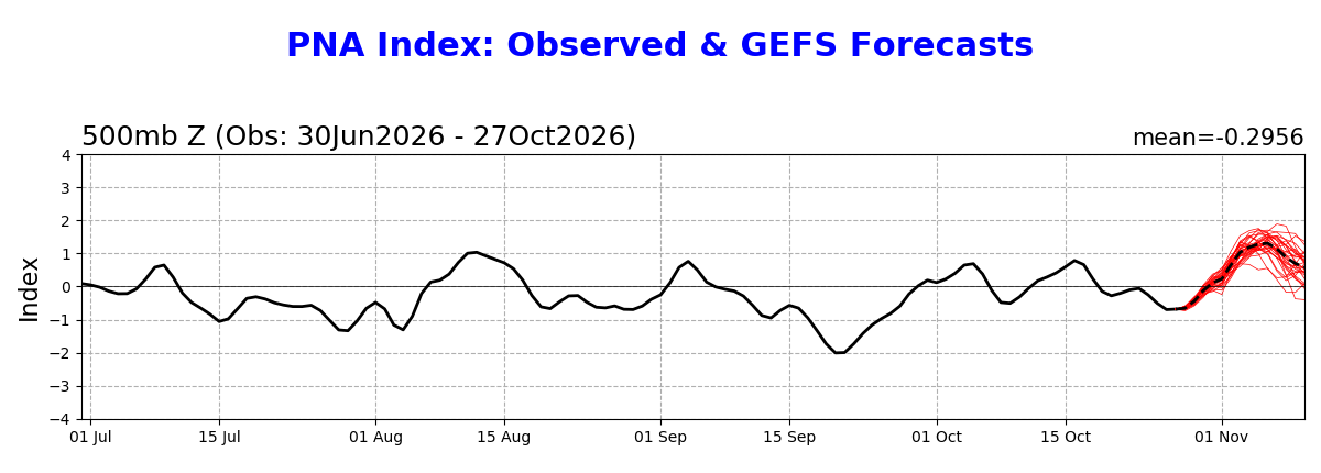
PNA probably stays ++ all winter. Remember one of the measuring points lies in the SE US, so the SE trough combined with the GOA low centered just offshore of western Canada will keep it positive. -
2026-2027 Record-breaking El Nino
SnowGoose69 replied to Stormchaserchuck1's topic in Weather Forecasting and Discussion
It depends WHY its happening though. Is it a product of the strong El Nino or the location of the anomalies? If so it probably means another SSW in Jan/Feb is unlikely unless somehow the El Nino is still at very strong magnitude at that time. But usually by then its weakening fairly quickly. -
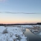
Watering your cabbage?
-
Yep the double dip of Falls Lake is just about complete, meaning it is about to match the summer low within the next day or so.
-

2026-2027 Record-breaking El Nino
GaWx replied to Stormchaserchuck1's topic in Weather Forecasting and Discussion
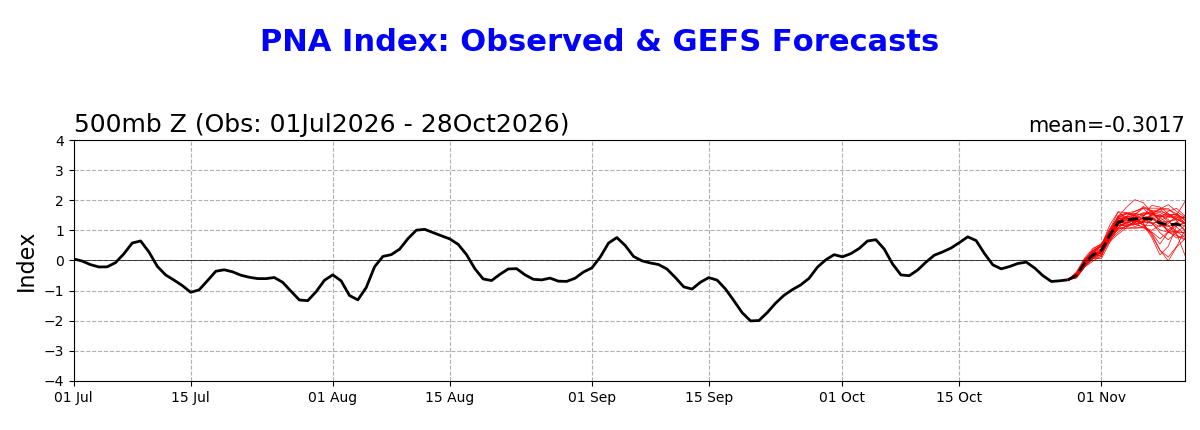
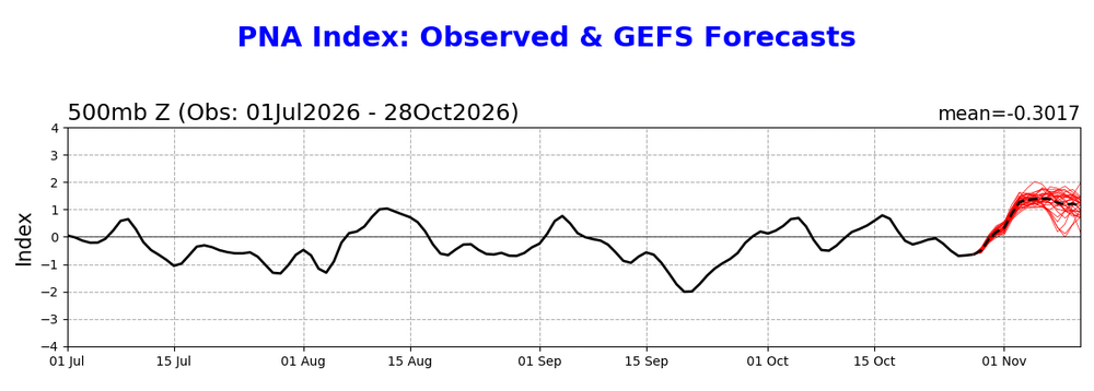
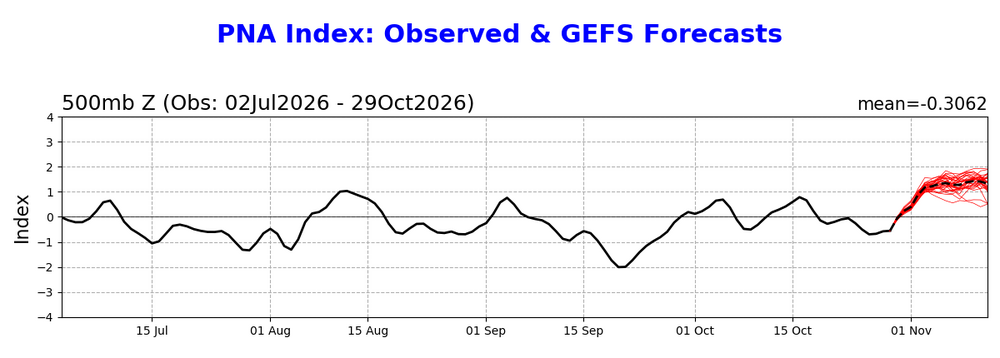
Whereas the GEFS -AO looks significantly less impressive than yesterday, the +PNA still looks very impressive for at least the 3rd day in a row: 10/27 run: 10/28 run: 10/29 run: even a bit more impressive Granted, the GEFS has had a +PNA bias averaged out the last 3 months, but the bias has had only ~half the magnitude of its -AO bias, and it has been mainly after day 7. So, perhaps it’s a bit too +PNA late in the run but otherwise likely has the right idea. I’ll for now assume it has the right idea for the first half of Nov with a PNA of near or above +1 most of the days. What other Nino first half of Nov had a mainly +PNA that was pretty high? 2014, 2002, 1997, 1987, 1976, 1968, and 1953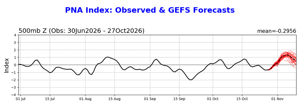
-
2026-2027 Record-breaking El Nino
Typhoon Tip replied to Stormchaserchuck1's topic in Weather Forecasting and Discussion
Yeah, I'm not sure it's all that real either... as winter enthusiasts, we would rather not see the cumulative error products for D7 and D10 leads indicating a 2 SD positive busting ..haha.. prooobably's a red flag. It could also correct - -
Keep her going…. K&R Extended season farmers market.
-
2026-2027 Record-breaking El Nino
snowman19 replied to Stormchaserchuck1's topic in Weather Forecasting and Discussion
The EURO refuses to back down whatsoever. Still insists on a December peak and holds on to the astronomical, record-shattering warmth in regions 1+2, 3 and 3.4 In other non ENSO news, the +QBO has fully downwelled to the bottom of the stratosphere and continues to strengthen. A very strong positive event has developed. And as @LakePaste25 and myself suspected, the rise in the PDO continues….up to -0.72 I still suspect we see it go weak positive by winter -
14 days straight no rain , another 7 until we maybe get some.. heading out to water the garden !
-

Yellow Medicine County, MN - Climate Fact or Climate Fiction?
ChescoWx replied to Cobalt's topic in Climate Change
Agree 100% the actual data is clear and consistent across the entire USA not just Yellow Medicine or Chester County. -
2026-2027 Record-breaking El Nino
GaWx replied to Stormchaserchuck1's topic in Weather Forecasting and Discussion
Thanks, Adam. Point taken, which @Typhoon Tipand many of us agree with. In case you missed it yesterday, Eric also suspects the occurrence of this very early SSW is connected in some way to the very strong and E based Nino: I have a sneaking suspicion that the extreme eastward shift (& intensity) of this year's El Niño potentially has something to do w/ the unusually early stratospheric warming event that's being forecast. -

Central PA Autumn 2026
Itstrainingtime replied to canderson's topic in Upstate New York/Pennsylvania
Even though we don't get much at all along the southern tier, you can see that the pattern's changing. This is an impressive amount of the country getting precip: -

2026-2027 Record-breaking El Nino
forkyfork replied to Stormchaserchuck1's topic in Weather Forecasting and Discussion
rainy coastals instead of cutters -
If this warmup stops short of 80 then I think we’re done with 80s for the year.
- Today
-
Fake heat at night…I like that. That’s what we’ll use. And unless today is going to be 74 degrees…it won’t be +15 above.