All Activity
- Past hour
-
luckily looks like the real high grade stuff should stay east of mby
-
 May see a decent line of storms move through Saturday evening...probably some decent wind potential. maybe even a TOR
 -
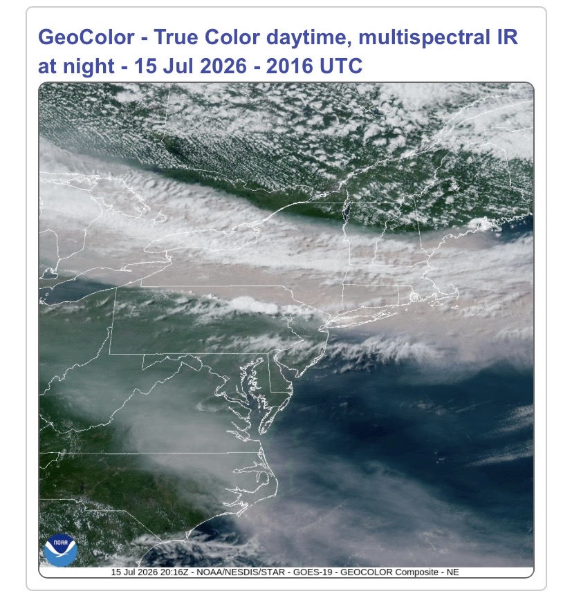
Hmm I dont smell smoke and this image would show the highest smoke density up North still
-

2026-2027 Super El Nino
bluewave replied to Stormchaserchuck1's topic in Weather Forecasting and Discussion
This could be the first event that is still a super El Niño into March using Nino 3.4 -

Central PA Summer 2026 Discussion/Obs Thread
mahantango#1 replied to Voyager's topic in Upstate New York/Pennsylvania
-
Central PA Summer 2026 Discussion/Obs Thread
mahantango#1 replied to Voyager's topic in Upstate New York/Pennsylvania
-
Central PA Summer 2026 Discussion/Obs Thread
mahantango#1 replied to Voyager's topic in Upstate New York/Pennsylvania
96 here yesterday with a dp of 79 seen a heat index at times of 112 -
Yuck. I think the highest I saw on my phone during Smokeageddon '23 was in the high 300s. 156 right now. Definitely has that hazy look and campfire smell.
-
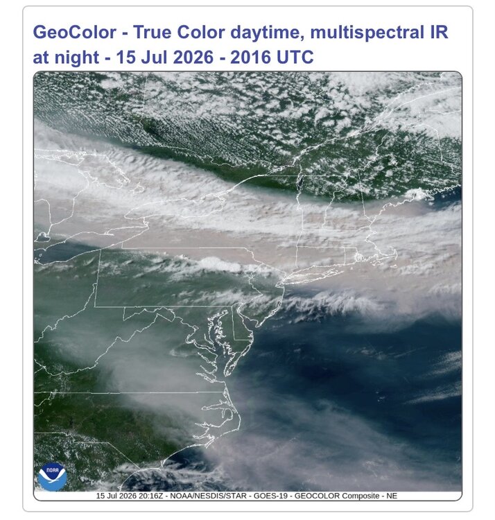
Advancing smoke shield just after a cloudy sunrise.

-
All these wildfires have their own scent, this one is nasty
-
For now it’s not bad sitting at 115. But the extreme AQI is not far to our NW.
- Today
-

2026-2027 Super El Nino
snowman19 replied to Stormchaserchuck1's topic in Weather Forecasting and Discussion
@Mitchnick Which models are you looking at that always show the trade winds coming back? Because you’ve been saying that for quite awhile now and all we’ve seen are record breaking WWBs, westerlies and a complete trade wind reversal -

Central PA Summer 2026 Discussion/Obs Thread
Voyager replied to Voyager's topic in Upstate New York/Pennsylvania
A little cooler here this morning at 69 degrees. We got 0.05" of rain from the storms that missed to the east yesterday afternoon. Despite that, the high was 95. -
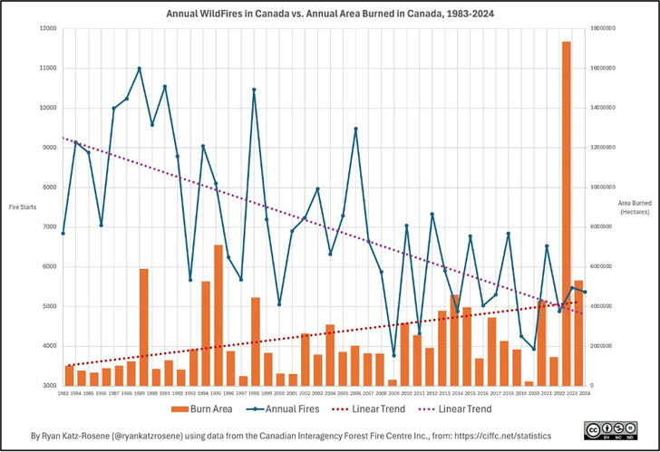
Good 2-part blog from last year on Canadian wildfire history outlining the role of forest management and climate. Canadian forest fires are less numerous than in the past; but, larger and burning a wider area. The cause of fires has transitioned from mostly man-made in the past to mostly ignited by lightning today. https://thetradeoff.substack.com/p/north-americas-forests-used-to-burn https://thetradeoff.substack.com/p/part-2-many-of-north-americas-forests
-
AQI 104-120 Yuck
-

Central PA Summer 2026 Discussion/Obs Thread
pawatch replied to Voyager's topic in Upstate New York/Pennsylvania
70 degrees this morning. DP 69 Looks like the 90’s today for the high. Only made it to 97 yesterday. Missed a line of thunder storms. -
Wait.... i thought we were going to have low dews for this heatwave. Dewpoint here is close to 80 lol. Yay! Smoky, hot, dry, super humid. I can't understand how anyone can love summer. Give me a 4:47 sunset and a -10 wind chill over this bs any day. And snow!! Feet of snow!
-
 Perfect weather for this time of year!! Today Widespread smoke, mainly after 1pm. Mostly sunny, with a high near 78. Light west wind increasing to 10 to 15 mph in the morning. Winds could gust as high as 30 mph. Tonight Isolated showers before 10pm. Widespread smoke, mainly before 7pm. Partly cloudy, with a low around 56. Northwest wind around 6 mph becoming calm in the evening. Chance of precipitation is 20%. Friday Sunny, with a high near 77. Northwest wind 3 to 8 mph. Friday Night Increasing clouds, with a low around 58. Calm wind. Saturday A chance of showers and thunderstorms, mainly after 3pm. Partly sunny, with a high near 78. Light southwest wind increasing to 8 to 13 mph in the morning. Winds could gust as high as 25 mph. Chance of precipitation is 30%. Saturday Night Showers and thunderstorms likely before 9pm, then showers and possibly a thunderstorm between 9pm and 2am, then a chance of showers after 2am. Low around 65. Southwest wind 7 to 11 mph, with gusts as high as 21 mph. Chance of precipitation is 90%. Sunday A chance of showers before 8am. Mostly sunny, with a high near 76. Northwest wind 8 to 11 mph, with gusts as high as 21 mph. Chance of precipitation is 30%. Sunday Night Mostly clear, with a low around 57. Northwest wind around 5 mph becoming calm in the evening. Monday Sunny, with a high near 77. Calm wind becoming west around 5 mph in the afternoon. Monday Night Partly cloudy, with a low around 62. Calm wind. Tuesday A chance of showers and thunderstorms. Partly sunny, with a high near 75. Calm wind becoming southwest 5 to 8 mph in the morning. Chance of precipitation is 30%. Tuesday Night Showers and thunderstorms likely. Mostly cloudy, with a low around 59. Southwest wind around 6 mph becoming light and variable after midnight. Chance of precipitation is 60%. Wednesday A chance of showers. Partly sunny, with a high near 75. West wind 5 to 8 mph. Chance of precipitation is 50%.
 -

2026-2027 Super El Nino
mitchnick replied to Stormchaserchuck1's topic in Weather Forecasting and Discussion
He's not talking about right now, but that it will trend more basin wide as supported by subsurface and is depicted on seasonal models. Models apparently seeing westerly anomalies weakening during the fall allowing trades to move the warmth in the esst back west. -
 pharmacy mexico: Mexican Pills - pharmacy order online
 -
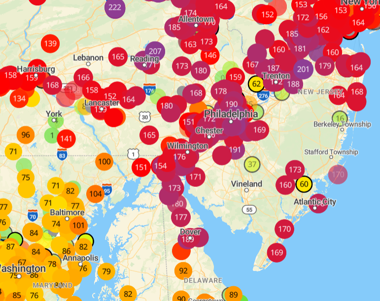
here we go. smoke is here. Smelly outside
-
Mine is 285, by far the highest I've ever seen. Looking out in the pitch I see what looks like fog particles and falling, but its likely another 3 let word. WUN keeps getting got that there is rain nearby or that its possible - its picking up the radar artifacts from the ash up in the sky. God help us if it actually rains.
-

2026-2027 Super El Nino
George001 replied to Stormchaserchuck1's topic in Weather Forecasting and Discussion
I’m skeptical that we don’t get a major La Niña snap back after a Godzilla El Niño. There is a good chance this El Niño becomes the strongest event since the industrial era. -
 GOES-19 is down indefinitely, aka the only way I know of via satellite to follow where the smoke is. Go figure lol
 -
2026-2027 Super El Nino
snowman19 replied to Stormchaserchuck1's topic in Weather Forecasting and Discussion
This is a decidedly east-based (EP) event. The 30C isotherm east of the dateline strongly supports an extremely east-based event like 1997 was. The difference is that this one is going to be stronger than 1997-98….In fact, likely the strongest one in history @LakePaste25