All Activity
- Past hour
-

November 2025 general discussions and probable topic derailings ...
alex replied to Typhoon Tip's topic in New England
Snowing well now
-
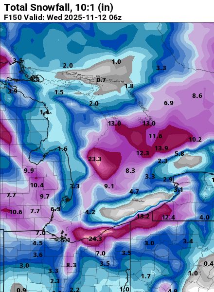
Seems like the models are shifting to a more NW wind direction. Still a long way out but some of the clown maps are interesting... CMC with a 2' bullseye over downtown.
-
I think its more valid for further north. The southeast ridge should be more prevalent than last winter.
-
Everyone is bullish for next month and early January. Its the end of January through March that we have to watch out for a crappy pattern.
-
Hello Mr. Bluesky. Light winds still but the sun is shining bright.
-

Overnight Wednesday, November 5, 2025 Wind Event
weatherwiz replied to weatherwiz's topic in New England
Just went back and looked and noticed the models backed off on the narrow jet streak of 130+ knots it had developing around the base of the trough. Looked through at 0z models last night and yeah that shortwave was vastly different than what was modeled just a few days ago. -
 So many more need to come down. My brother had a dead up up root last week due to the rotten roots, the tree itself stayed intact.
 -
Would you be able to say that for the Mid-Atlantic, or is this only valid for New England?
-
I was going to say it’s been a long time since we’ve seen this much cooling in the NE PAC and it’s still ongoing
-

Overnight Wednesday, November 5, 2025 Wind Event
CoastalWx replied to weatherwiz's topic in New England
The low simply trended weaker. Shortwave not as potent and rapid low development did not take place. -
12-18"? Where is @Solution Man's "sign here" poster?
-
 Had a few dead ash drop; they needed to come down anyway, so a net positive here.
- 58 replies
-
- 1
-

-
- wind damage
- power outages
- (and 1 more)
-
Is the KU book on Northeast Snowstorms still worth reading, or is it too dated now? I’ve never read it, but I found someone online selling it used at a significant discount.
-
I was at the game last night…amazing to see and what a way to score the 900th with a sick goal. And Binnington tried to steal the puck, what a turd.
-

Central PA Fall Discussions and Obs
Mount Joy Snowman replied to ChescoWx's topic in Upstate New York/Pennsylvania
Low of 42 here with .03" of rain. Another new one today, as the national low of 15 comes from Grantsburg, WI. Looks like that rain tomorrow night should be moving in right as the Hempfield vs Manheim Township playoff game kicks off. Rats. Me and a buddy were thinking of taking our boys to the game. Not sure now. -
Central PA Fall Discussions and Obs
Mount Joy Snowman replied to ChescoWx's topic in Upstate New York/Pennsylvania
Not that I can tell. We seem to have avoided any issues at my place. I'm with you though, there were some moments where I thought for sure I was going to be hearing a big pine limb come down. Thankfully not. -

2025-2026 ENSO
40/70 Benchmark replied to 40/70 Benchmark's topic in Weather Forecasting and Discussion
I agree with what you are saying, but I highly doubt this "screw zone" is permanent...part of the issue has been the lack of cold in SE Canada, which seems to be changing, so there will be more snow indepenedent of BM blizzards. -

November 2025 general discussions and probable topic derailings ...
Typhoon Tip replied to Typhoon Tip's topic in New England
Unlikely to have legs if were even real, not with the entire compendium of polar indexes collapsing ... But that's likely 'post bating' anyway - -
The problem was that as soon as a ridge would try to get established in the West, the Pacific jet would just knock it down or shove it east which meant storms couldn’t turn the corner in a good place for us and they’d be forced out to sea. We also couldn’t get a well timed phase with so much chaos and shortwaves everywhere. That’s why I’m so pessimistic about our chances especially north of DC to south of Boston with this pattern continuing. I-90 to maybe I-84 can still get good events from SWFE, very rarely down here when everything aligns. The suppressed patterns can help the DC/Baltimore area and south. East of I-81 and north of the M/D line to around the I-84 corridor, we need those benchmark tracks to have a shot at normal snow. We’re in a unique shaft zone here with this new regime.
-

Central PA Fall Discussions and Obs
mahantango#1 replied to ChescoWx's topic in Upstate New York/Pennsylvania
The American Storm @BigJoeBastardi · Nov 3 The second season for severe weather may be big this year between November 15 and 25. Plenty of warmth coming, huge jet crashing into the west and then working east. After the 25th, a lot of cold may take over and limit second season -

Central PA Fall Discussions and Obs
Itstrainingtime replied to ChescoWx's topic in Upstate New York/Pennsylvania
My temp went from 57 at 6pm to 68 at it's peak as the front arrived at 8:45pm. (then plunged 16 degrees over the next 20 minutes) -
Did I miss the drought monitor? Seems to be a late post?
-
Central PA Fall Discussions and Obs
Itstrainingtime replied to ChescoWx's topic in Upstate New York/Pennsylvania
Anything noteworthy last evening over your way? That was a legit high wind event in Maytown. Branches down everywhere around town. Several large trees on the shoulder going over Chickies this morning. I was "anxious" for a few hours due to the strength of the wind. -
Formidable repeatable block N Canada-Greenland to persist into the week before Thanks giving (at least the 20th). Going to be interesting. Was all this blocking modeled beyond two weeks in advance? I like the cool season start UA pattern. Can't rule out first T of mixed r-s shower CP around next Tuesday as a very sharp trough exits. Probably wont happen but am sure of first flurries much of the I84 corridor this coming Monday-Tuesday, with low power prob some light grassy accums. Another wind event modeled- suggested later next week or weekend.
-
Overnight Wednesday, November 5, 2025 Wind Event
weatherwiz replied to weatherwiz's topic in New England
I also wish this would have busted with the LLJ that was advertised a few days ago versus busting because the LLJ just didn't pan out. If we got the 50-60 knot LLJ, I wonder if last night would have performed or not. I find these setups to be interesting, whether its 35-45 mph gusts or something that has potential for 50-60 mph. Over the years we've had plenty of times where wind advisories (this includes high wind) were issued and nothing happened, and times it's like "where the heck is the wind advisories". I am also wondering if the showers helped to develop or enhance a subtle inversion above the surface which maybe knocked off like 10 mph of gust potential? Was looking at some 6z NAM bufkit soundings and there are some subtle inversions just above the sfc.


