All Activity
- Past hour
-

2026-2027 El Nino
bluewave replied to Stormchaserchuck1's topic in Weather Forecasting and Discussion
Will be interesting to see if the Euro April 5th release turns out to be as reliable as its El Niño forecast issued back in April 2023. https://iri.columbia.edu/our-expertise/climate/forecasts/enso/2023-April-quick-look/?enso_tab=enso-sst_table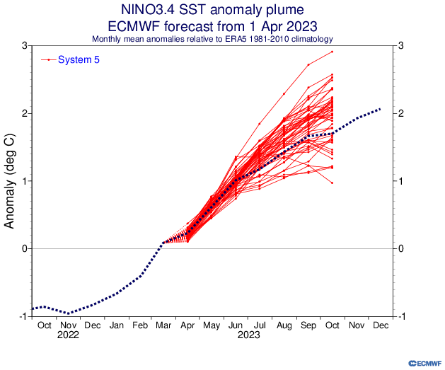
-
Still 45 here ...altho the sun's out. As I predicted ... WPC's razor sharp sfc analyses skill has the warm front retreated safely back N of here despite the fact that 0 home sites and even NWS' own KFIT are all clearly still not in a warm sector ....
-

Central PA Spring 2026 Discussion/Obs Thread
Itstrainingtime replied to Voyager's topic in Upstate New York/Pennsylvania
A ridiculous low of 65 this morning. No rain at home or at work but a pretty good shower fell in between. Anyone see any snow piles left when you're out and about? Columbia Borough still has a pile about 2-3' deep in a vacant lot along the river. Last week at this time it was at least 5' so I'm not sure it has another week left in it or not. Still impressive considering how long it's been since it's snowed and how warm it's been over the past several weeks. -
62 here already
-
Yeah, looks like another warmer month coming up as the Western and Eastern ridges merge like we saw in March.

-
Nah seasons in seasons. You won’t see that in January.
-
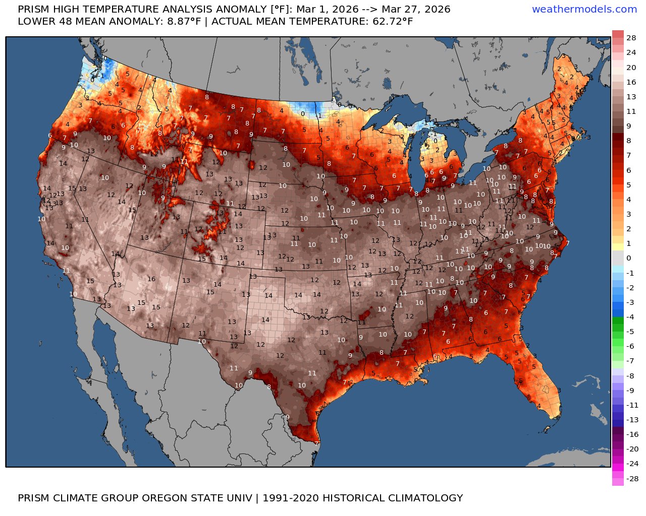
Yeah, we have been at daily record levels since the 23rd. https://bsky.app/profile/climatecasino.net/post/3mhv47nbqqk2j Earth's global 2m surface temperature just posted the hottest March 23rd on record, and likely the hottest March 23rd in the last 120,000+ years. 8:38 AM · Mar 25, 2026
-
12/30/00?
-
Always funny to me how our warmest weather near the coast this time of year is after the cold front passes.
-
Good chance of hitting 80 here today if we can keep westerly wind for a while.
-
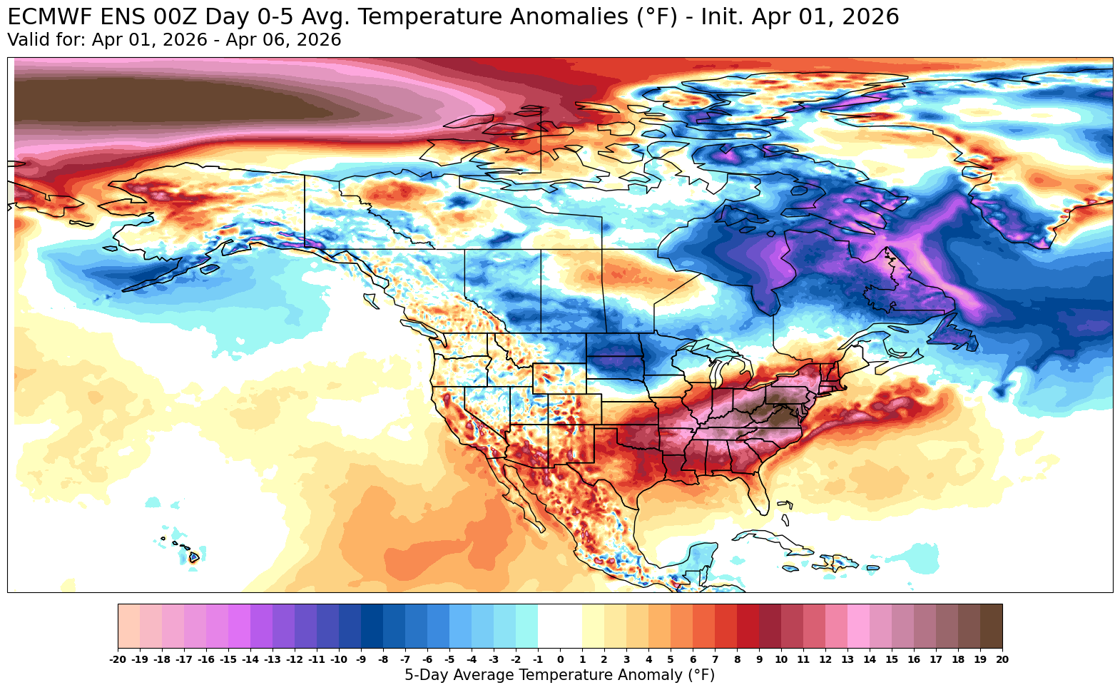
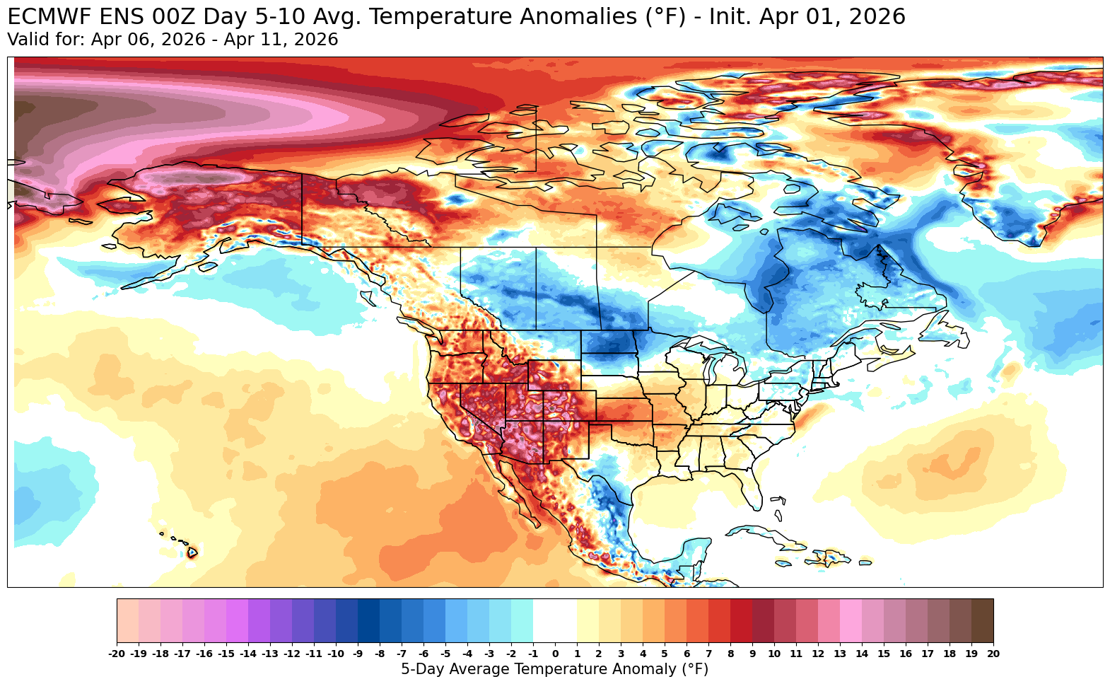
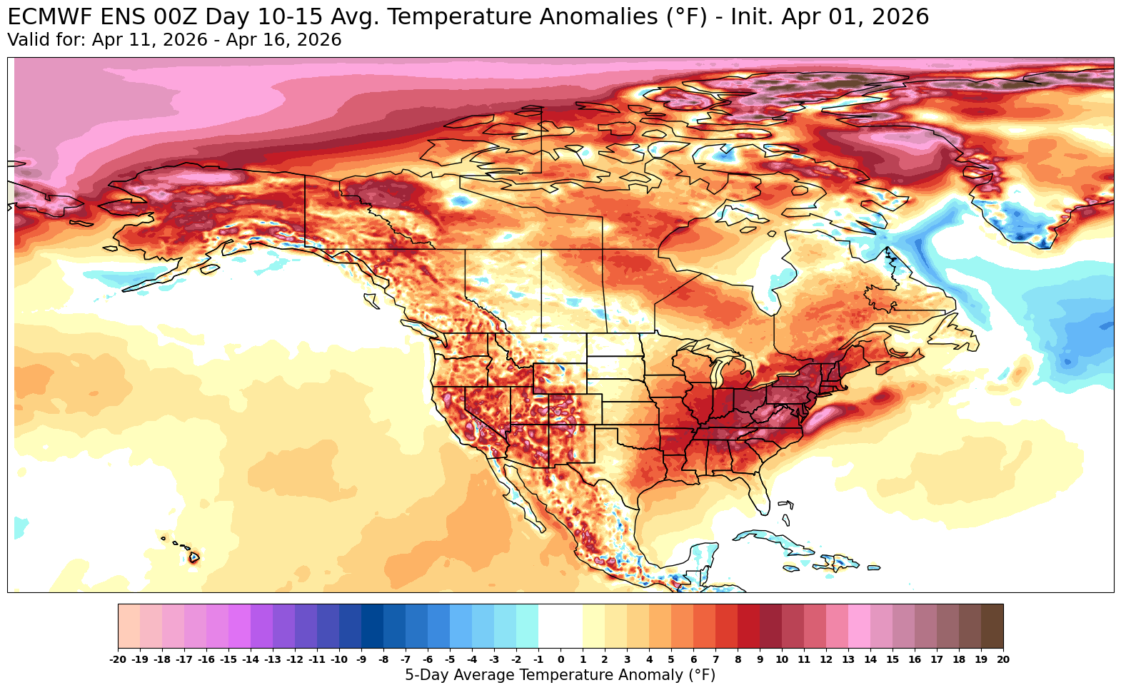
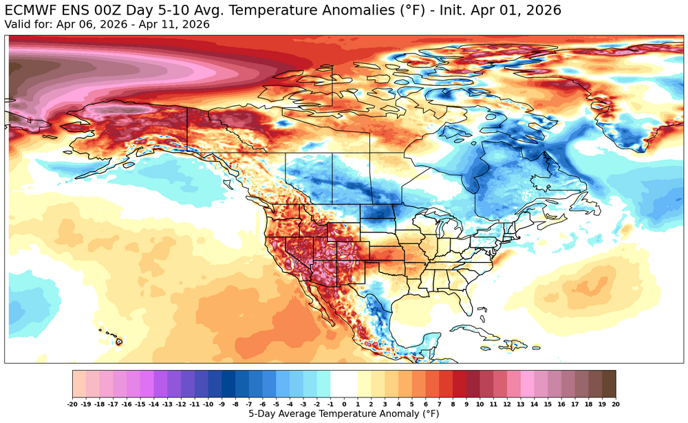
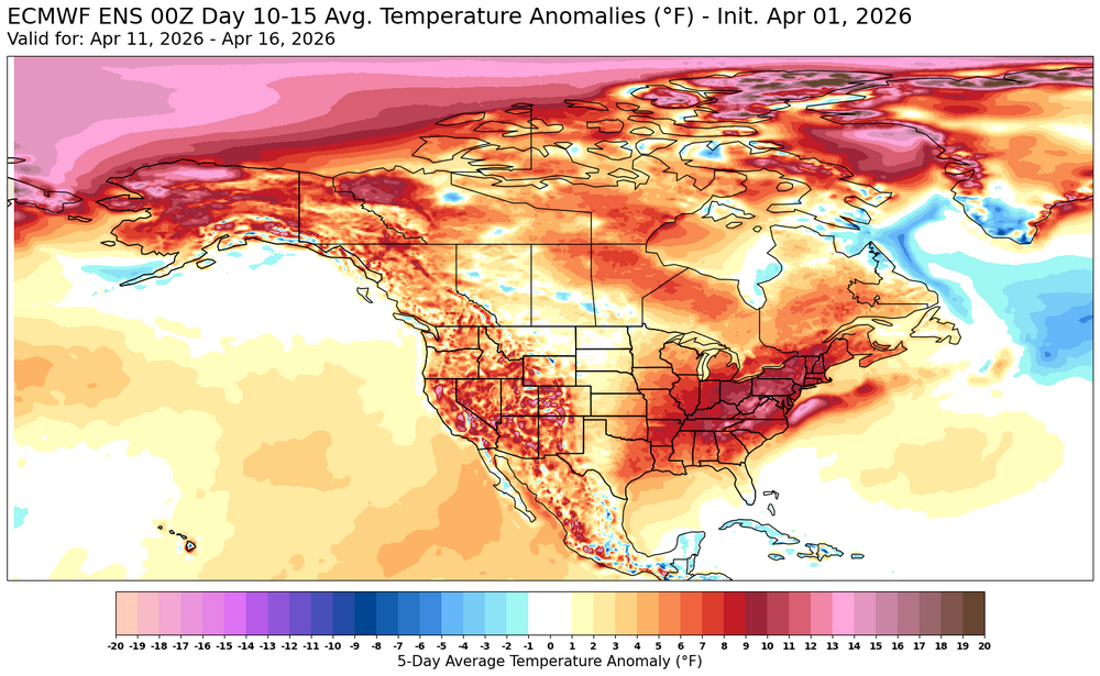
70 / 55 in / out sun. Some 80s in the warmest spots, enough sun , otherwise 70s and some afternoon showers, rain. What goes up must come down - for 18 hours - chill down Thursday with onshore / backdoor. Back up Friday clear out and warms up 20-25 degrees from Thu back to upper 60s / low 70s. Warm Easter weekend , showers and rain on Easter. Near normal next week by way of back and forth with the coolest period 4/6 - 4/8. Much warmer in the 4/10 - mid month period and beyond with ridging into the East coast.
-

2026-2027 El Nino
40/70 Benchmark replied to Stormchaserchuck1's topic in Weather Forecasting and Discussion
It did well last year. I was skeptical it would end up that cold. Interesting to see how it does this year. -

2026-2027 El Nino
mitchnick replied to Stormchaserchuck1's topic in Weather Forecasting and Discussion
New Cansips out on TropicalTidbits. Similar to last month with lots of blocking. Drier for the east coast than typical for a Niño, but it's a long range forecast. -
Back in the market?
-
By the turn of the decade your metamorphous to torchtiger will be complete.
-
Don’t see the is everyday:
-
Last of my neighbor's snow-blow pile will go today. I melted out Sunday.
-
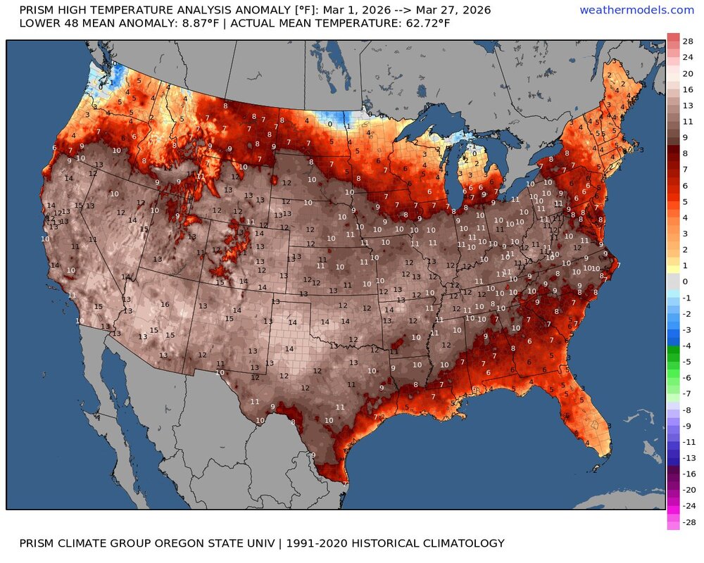
 Another issue: the shelters 100 years ago were not aspirated. Inadequate or poorly sited shelter ran warm. With his number of days metric easy for one or two sites with bad data to bias the result. We saw that in the Chester county, where spuriously warm data from Phoenixville in the 1930s and 1940s biased the >95F day data, by providing the overwhelming majority of the County 95F+ days in that period. Better to show the data for every station like chart below. That way a few bad apples don't skew the data. Threadx cities plotted below have the longest climate records.
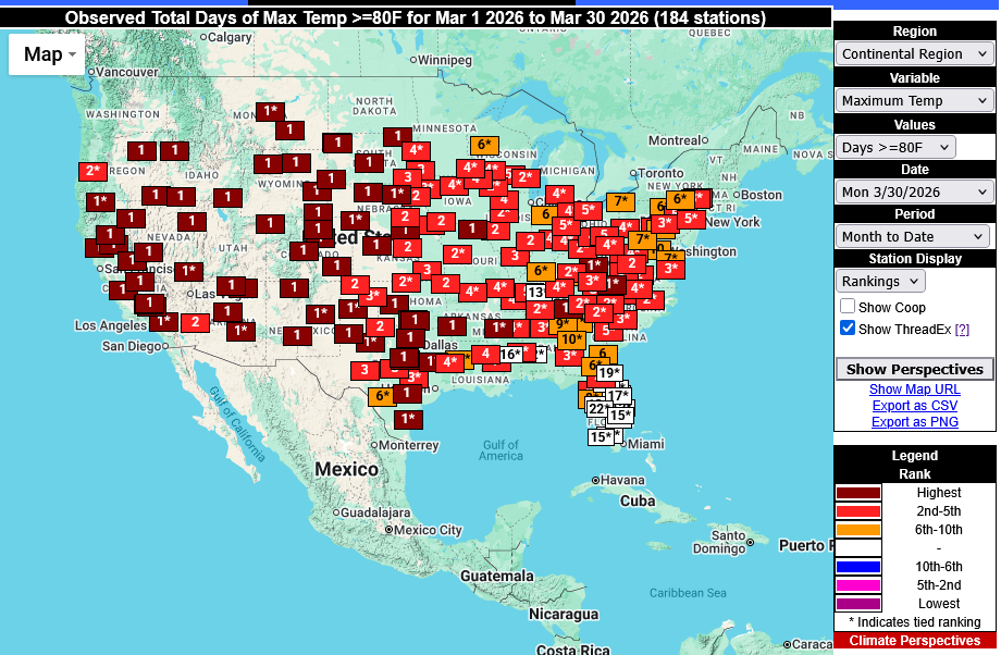
-
60 at 8 am on 4/1. Solid start to the month.
-
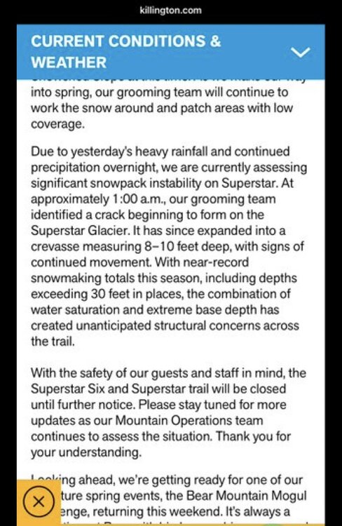
Quite a bit of sleet and freezing rain modeled to impact the metro area this evening. Rooting for the warm nose to over preform and keep us liquid on this one.
- Today
-
Still snow piles here
-
 Bad methodology. Notice he uses MT and WY. 90s in March are virtually assured to be near or at zero. Thus he assures himself the kind of conclusion he seeks. A more robust approach would involve standardized measurements, e.g., the number of highs 1 sigma, 2 sigma, etc., above the 20th century baseline.
 -
For a coffee break...
-
April Fools Anyone know the storm ?
-

Central PA Spring 2026 Discussion/Obs Thread
pawatch replied to Voyager's topic in Upstate New York/Pennsylvania
80 was the high yesterday. Rainfall yesterday and over night .25” Grass is starting to grow. Maybe next week first cut.