All Activity
- Past hour
-

December 2025 regional war/obs/disco thread
Damage In Tolland replied to Torch Tiger's topic in New England
We’ve always said .. at least screamers bring exciting weather, damage etc. If you’re gonna lose pack .. at least have it come with some exciting weather -
pacific is just more powerful than the atlantic
-
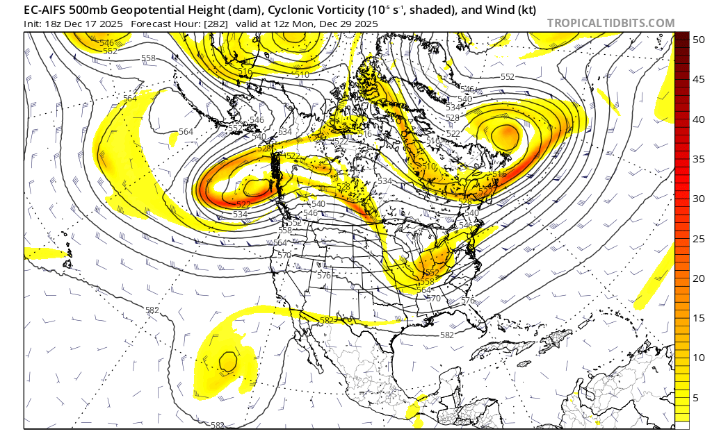
Euro AI is rain to snow. Block and confluence flexing and forcing. I don't have high hopes for anything until the pac trough backs off but to get something to work we need a gnarly block and all models are showing something to that effect.

-

Central PA Winter 25/26 Discussion and Obs
Blizzard of 93 replied to MAG5035's topic in Upstate New York/Pennsylvania
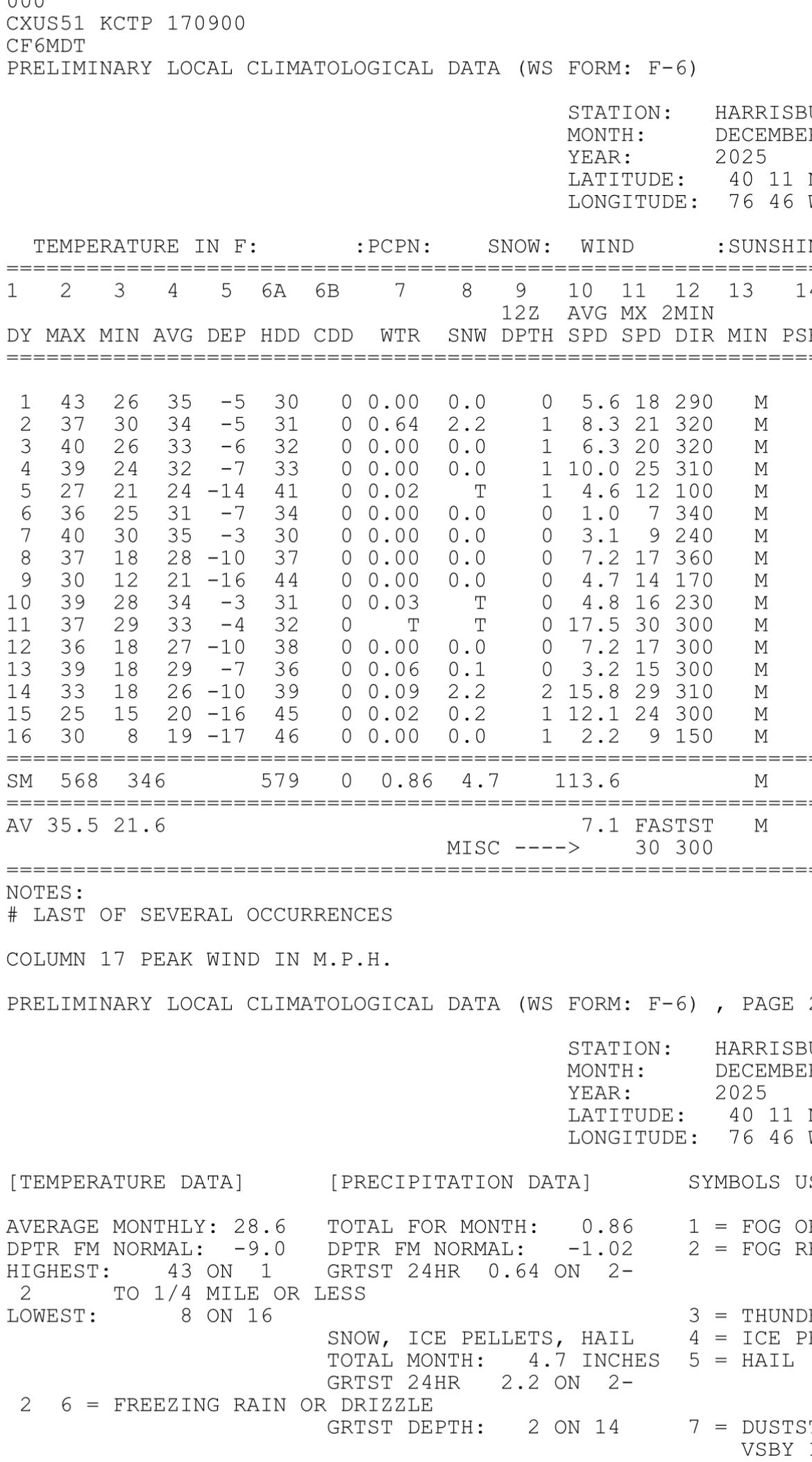
It is truly remarkable that MDT is running 9 degrees below normal temperature for the month through 12/16. What a cold stretch, along with above normal snow for the season to date at 4.7 inches. Great start to the season & hopefully we are on our way to a good Winter that is overdue for many of us.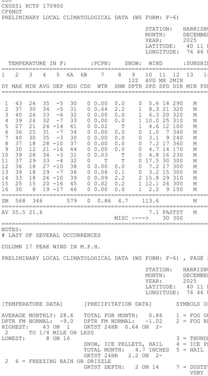
-
12/29-30 is probably our best chance, but it's still a long shot. OPs have been showing ways we can score for a decent amount of time and ensembles have a decent signal, but we're kinda grasping on straws here lol. EPS shows that kind of ugly central-US ridge, but it also shows an pretty strong east-based -NAO. Even though it's a -NAO, it's an east-based -NAO, so while it'll help with a torch it's not going to do much otherwise IMO. h5 flow would suggest WAA aloft but at least it's somewhat cold at the surface so snow changing to mix or rain has a decent chance. More of a conditional setup where timing is absolutely key, so wouldn't hold too much hope unless the -PNA/+EPO trends towards neutrality and/or that NAO block trends more west. We still have time though, 288 hours is more than enough time for those things to happen.

-
Central PA Winter 25/26 Discussion and Obs
Blizzard of 93 replied to MAG5035's topic in Upstate New York/Pennsylvania
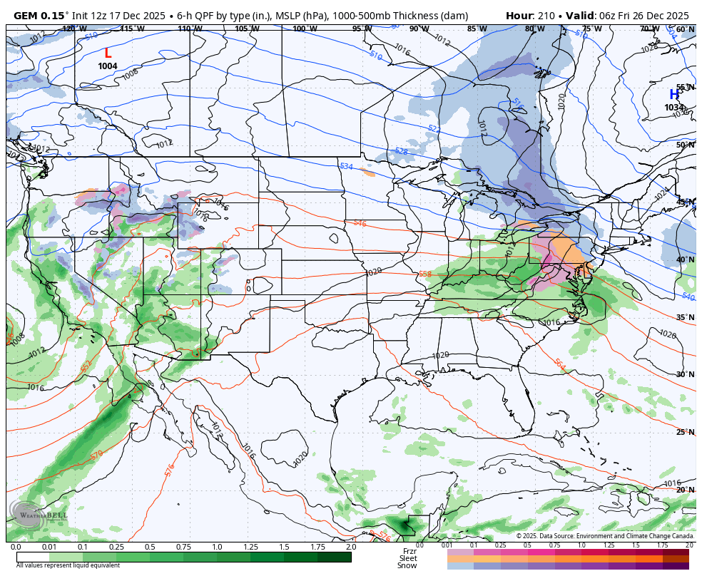
The Euro has a similar look but is displaced a little further north & east with mostly rain for CTP around Christmas. The GFS has been bouncing around today. The general idea of a wave tracking near us is there sometime around Christmas Day, but the details need resolved as the week goes on. Hopefully we end up on the right side of the boundary to get a couple of inches of snow to a mix if we get the right track & the cold in the northeast can hold in enough east of the mountains.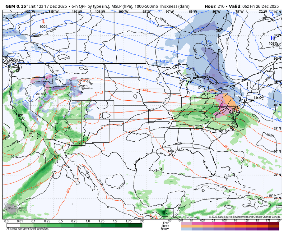
-
Central PA Winter 25/26 Discussion and Obs
Blizzard of 93 replied to MAG5035's topic in Upstate New York/Pennsylvania
The Canadian looks a lot like the 6z GFS from earlier today with a chance of a little snow to icy mix for many of us.
-
.50" won't do squat to the pack, The temps and dews will do some damage though but its short lived, Clubs will be out panning and rolling the trails after but the best thing is for folks to stay off of them until they set back up.
-
That's an aggressively wet gfs run
-
Hmm.. maybe
-

December 2025 regional war/obs/disco thread
WinterWolf replied to Torch Tiger's topic in New England
Right now…they’re calling for a half inch of rain up there…not overly horrible. But I’d love it to be even less than that. -
From Jason Boyer- AVL’s 30-year average snowfall has dropped from 14” to 10.2”. That’s 27% less snow annually.
-
.
-
Wakefield put 4 inches where I live and I got 6 inches. They did it again. Summary of December 8, 2025 Snowstorm
-
LWX is confident too much sfc stability, but I’m not so sure we don’t get some sort of dynamics that could break through. Won’t be widespread.
-
Need to get thru friday and early saturday up there, But it looks like snow showers off and on thereafter for a couple days, Have to wait to see how things shake out next week, But i think up there some of these clippers or overrunning events are going to pan out .
-
yes, you have proven your criteria and expectations are outlandish.
-
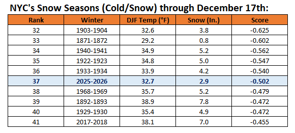
Winter 2025-2026 is off to the 37th best start in terms of cold and snow in New York City. Records go back to 1869-1870.
-
December 2025 regional war/obs/disco thread
WinterWolf replied to Torch Tiger's topic in New England
We’re hoping for a week from Friday…the 26th for St Agatha. They’re grooming and in decent shape up there…but Friday is gonna be key. And if they can grab something after Friday? So the less rain the better way up there for our possible plans. - Today
-
SWFE.
-
December 2025 regional war/obs/disco thread
WinterWolf replied to Torch Tiger's topic in New England
6 and 8 days away respectively…so lots will morph and change over the next 4-5 days. But at least there’s some potential. -
The pack should be able to absorb that amount, That's a good idea though going out tomorrow, Someone asked on FB if they thought trails would be good to come up and ride this weekend........lol, Stay the hell off of them after this storm and let them freeze back up.
-

December 2025 regional war/obs/disco thread
brooklynwx99 replied to Torch Tiger's topic in New England
the 23rd and 26th are both pretty interesting as vorts come over the top of that C US ridge. could be some WAA thumps -
We're in this pattern for a while I'm afraid. I think after New Years. Maybe middle of January.
-
I'm praying for a 18z GFS scenario, almost all other guidance has us well over 1 inch of QPF. Maybe it'll have a clue. We can survive 0.75, our snow is light and fluffy and will compact and we'd be back in business with another 6-8 inches. Riding from the house tomorrow afternoon for a quick 70 mile loop with some buddies in case Friday goes real sour.