All Activity
- Past hour
-

December 2025 regional war/obs/disco thread
Sey-Mour Snow replied to Torch Tiger's topic in New England
Euro OP has been horrendous lately it seems, let's hope GFS has a clue.. -

2025-2026 ENSO
40/70 Benchmark replied to 40/70 Benchmark's topic in Weather Forecasting and Discussion
I went 19-29" for you guys, so kind of the middle of those years. -
This “event” tomorrow is among the most frustrating just because it’s in the low 20s less than 24 hours before the precip moves in and we rain?
-
SOI value this morning. -43.70 Tanking
-
SOI value this morning. -43.70 Tanking
-
Mighty frosty on my morning walk. Im calling it a trace
-
-7 at the house. Got a -14 on the car thermometer at the local low spot. Winter is here, glad it matches the time of year I’m most excited for it
-
the HRRR isn't the 6z debacle
-
Not too familiar with cville microclimate but I'd worry about downsloping since the flow is basically east to west. Perhaps 1-1.5" is a safe bet for you. Just basing this on the HRRR and ignoring the NAM, which is about to get retired.
-
Special Weather Statement Special Weather Statement National Weather Service Baltimore MD/Washington DC 750 AM EST Thu Dec 4 2025 DCZ001-MDZ004>006-008-011-013-014-016>018-503>508-VAZ053>055-501- 502-505-506-526-527-041900- District of Columbia-Frederick MD-Carroll-Northern Baltimore- Cecil-Southern Baltimore-Prince Georges-Anne Arundel-Charles- St. Marys-Calvert-Northwest Montgomery- Central and Southeast Montgomery-Northwest Howard- Central and Southeast Howard-Northwest Harford-Southeast Harford- Fairfax-Arlington/Falls Church/Alexandria-Stafford- Northern Fauquier-Southern Fauquier-Western Loudoun- Eastern Loudoun-Northwest Prince William- Central and Southeast Prince William/Manassas/Manassas Park- Including the cities of Washington, Frederick, Ballenger Creek, Eldersburg, Westminster, Reisterstown, Cockeysville, Elkton, Baltimore, Bowie, Suitland-Silver Hill, Clinton, College Park, Greenbelt, Laurel, Camp Springs, Glen Burnie, Annapolis, Severn, South Gate, Severna Park, Arnold, Odenton, St. Charles, Waldorf, Lexington Park, California, Chesapeake Beach, Huntingtown, Dunkirk, North Beach, Lusby, Prince Frederick, Germantown, Damascus, Bethesda, Rockville, Gaithersburg, Silver Spring, Lisbon, Columbia, Ellicott City, Jarrettsville, Aberdeen, Reston, Herndon, Annandale, Centreville, Chantilly, McLean, Franconia, Arlington, Alexandria, Falls Church, Falmouth, Warrenton, Turnbull, Purcellville, Leesburg, Ashburn, Sterling, Haymarket, Dale City, Manassas, Woodbridge, Lake Ridge, and Montclair 750 AM EST Thu Dec 4 2025 ...POTENTIAL WINTER COMMUTING HAZARD FOR THE BALTIMORE/ WASHINGTON METRO AREAS FRIDAY MORNING... There is a potential for hazardous commuting conditions for the Friday morning commute. A period of light snow is POSSIBLE (a 30 to 50 percent chance) Friday morning across the Baltimore/Washington DC metro areas with up to an inch of snow possible accumulation on untreated roadways. If this threat does materialize during the Friday morning rush hour, many roads could quickly turn icy. This could lead to dangerous traveling conditions, multiple accidents, and extensive delays. If commuting Friday morning, be aware of the POSSIBILITY of significant travel disruptions. Plan ahead by allowing for extra travel time, and consider using public transportation and telework options. In addition, light snow or freezing drizzle accumulations may also impact the evening commute as the storm system is slow to depart late Friday afternoon and evening. Stay tuned for updates on this potential winter weather episode. $$ EST/DHOF
-
We cant catch a break
-
What would you expect for Charlottesville? I'm thinking that at least an inch is a safe bet with a max of 3 (1.5-2 is my target). Only worry is down sloping or a further slip south (though with the H5 that would be quite a change to skunk me) but generally I think I'm pretty locked in for a pretty Friday morning on Grounds.
-
(002).thumb.png.6e3d9d46bca5fe41aab7a74871dd8af8.png)
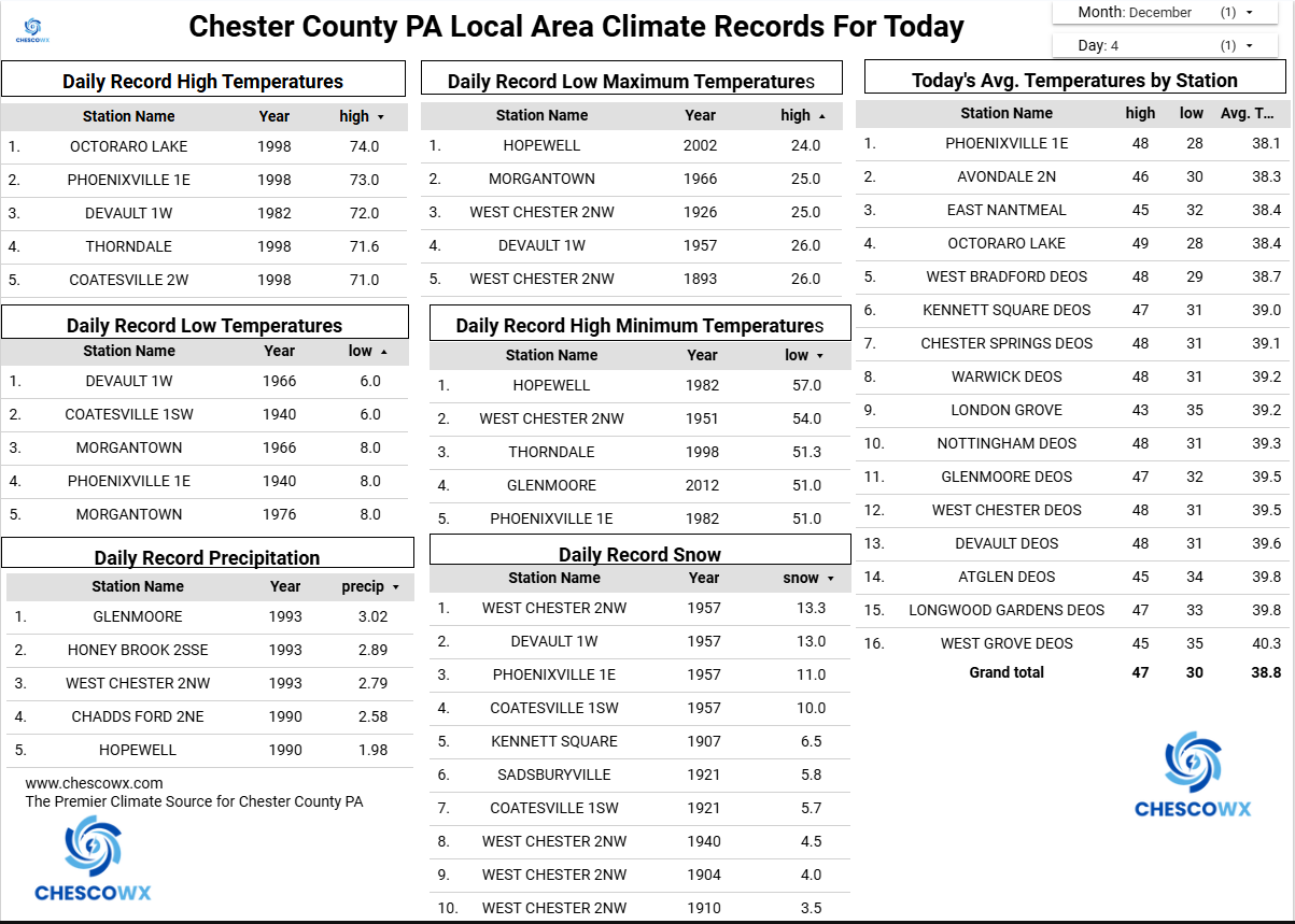
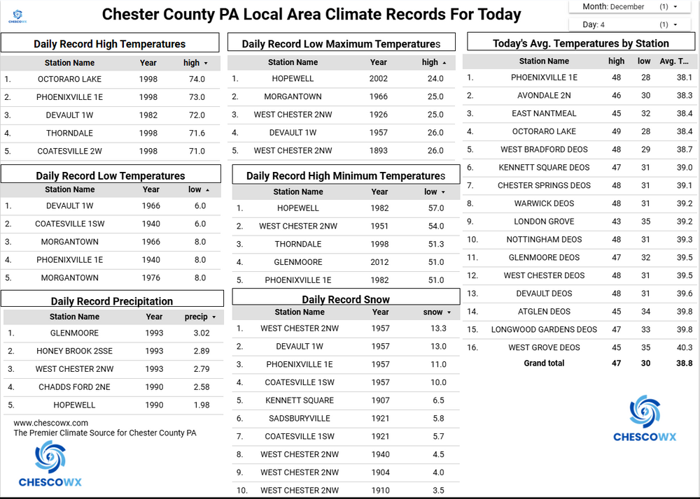
Central PA Fall Discussions and Obs
ChescoWx replied to ChescoWx's topic in Upstate New York/Pennsylvania
An arctic front moves through later today with maybe a couple snow flurries. We turn windy and cold behind the front with highs today in the mid-30's and lows tonight will be near records levels for some stations with shorter periods of record with lows by tomorrow morning in the mid-teens. We remain in the upper 20's for highs tomorrow with a chance especially across Southern Chester County for some light snow or flurries during the afternoon. While still well below normal we do warm back up to the upper 30's for the weekend before the coldest weather of the season arrives on Monday. No significant storms over the next week.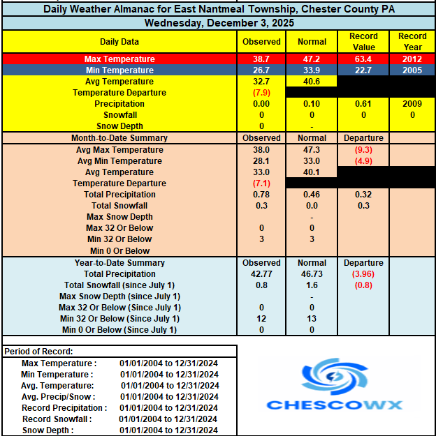
-
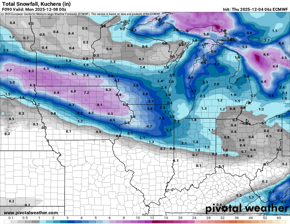
Got down to -8º here, with some -teens across northern Iowa. Models are amping up the weekend clipper. The latest Euro is fairly robust.
-
E PA/NJ/DE Winter 2025-26 Obs/Discussion
ChescoWx replied to LVblizzard's topic in Philadelphia Region
An arctic front moves through later today with maybe a couple snow flurries. We turn windy and cold behind the front with highs today in the mid-30's and lows tonight will be near records levels for some stations with shorter periods of record with lows by tomorrow morning in the mid-teens. We remain in the upper 20's for highs tomorrow with a chance especially across Southern Chester County for some light snow or flurries during the afternoon. While still well below normal we do warm back up to the upper 30's for the weekend before the coldest weather of the season arrives on Monday. No significant storms over the next week.
-

Mid to long range discussion- 2025
WinstonSalemArlington replied to wncsnow's topic in Southeastern States
-

Southern MD / Lower Eastern Shore weather discussion
SnowtoRain replied to PrinceFrederickWx's topic in Mid Atlantic
0 to 1" seems reasonable. -
-4F here. Maybe we’ll drop another degree or two. Bit of an underwhelming cold snap, our average first subzero low is December 10th so it did arrive early this year.
-
Yeah, its almost back to where 00z was, not quite as beefy but the northern extent is back up just north of the dc metro - and I'm looking at 1km radar not composite reflectivity. I wouldn't count us out yet. Just to clarify, my expectations are coating to 1" tops north of 66/50 up to 70
-
Yup congrats southern folks
-

Central PA Fall Discussions and Obs
mahantango#1 replied to ChescoWx's topic in Upstate New York/Pennsylvania
-
The swamp/pond seems to be fully frozen over this morning. Tidal South River partially frozen and thinner, as expected Low temp 25 with plenty of windshield scraping
-

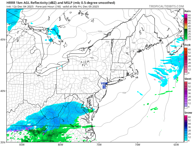
The Return of the 12/5 Snowstorm
SomeguyfromTakomaPark replied to SnowenOutThere's topic in Mid Atlantic
I am liking the look of the 12z HRRR compared to the overnight runs based on the first 15 hours, perhaps an improvement incoming. -

December 2025 regional war/obs/disco thread
weatherwiz replied to Torch Tiger's topic in New England
Mid-month is very interesting. As tip alluded to yesterday, that 500mb features lots of shortwaves digging and amplifying slightly south of Long Island...you keep feeding a constant supply of shortwaves and something is bound to give. I will say though and I know this leads to debate, but I would feel MUCH better if we had some southern stream involvement. If there was some southern stream feeding energy we could probably say the odds are almost certain something would happen. -
I saw that especially on gfs, but euro is a sheared out mess. I guess give it a day or so.