All Activity
- Past hour
-

January 2026 regional war/obs/disco thread
ORH_wxman replied to Baroclinic Zone's topic in New England
EPS going with the OP in LR in really driving that PNA ridge up. That would bring in the chance for some coastals maybe in the 3rd week of the month. -
Not uncommon...lol.
-

New Years Day 2026 - 1st snows of the new year possible
Cold Miser replied to Baroclinic Zone's topic in New England
@The 4 Seasons 3” total in Dayville (there may be some “official” numbers from East Killingly or Danielson too) -

January 2026 regional war/obs/disco thread
SnowGoose69 replied to Baroclinic Zone's topic in New England
Up until last winter the GEFS was owning the EPS on Pac based stuff for like 5-6 years in the long range, that changed last winter and so far this winter that trend has continued. What has happened though the past winter and a half now is the GEFS is owning the EPS long range on the NAO stuff it seems so maybe lean towards each idea on both with that -

Winter 2025-26 Medium/Long Range Discussion
roardog replied to michsnowfreak's topic in Lakes/Ohio Valley
Overall in the means the pattern has definitely been different than what we’ve seem from the mid 2010s until recently. It seems like it was just about impossible to get sustained western US ridging for many years. Alek always used to post about how it’s always wet in this new climate. We’ve seen some deviation from that recently too. -
Miserable day. I came down with that cold that’s going around to start the year off the right way. A thaw would be nice. A few days near 55 with no wind please
-

New Years Day 2026 - 1st snows of the new year possible
dendrite replied to Baroclinic Zone's topic in New England
Yeah BDR. I had just posted it. lol -
January 2026 regional war/obs/disco thread
ORH_wxman replied to Baroclinic Zone's topic in New England
Ensembles aren’t out yet…GEFS mostly out and they are kind of meh. OP euro decided to go cold post-1/11. -

January 2026 regional war/obs/disco thread
Sey-Mour Snow replied to Baroclinic Zone's topic in New England
Euro Colder, GFS warmer.. Going to be sometime to figure that period out.. We track the small events in the meantime -
Snow showers this morning. Might have eeked out 0.1" of fluff with that heavier band that went through. +/- sd's across NE MN this morning. Keeping my eye out for something decent 7-10 days out. My modelling method is showing potential, it looks like gov models are picking up on it, too.
-
I had 4.5” in that, ~10 miles NW of there, sitting at 16.5” on the season
-
My parents are in the north end near ydc. My dad estimated 2-3” from that. I wonder if the observer had .25 instead of 2.5. That would match up better with the MHT 0.02” QPF.
-
December fooled us a bit. The only trustworthy long range looks are ones that show CAD or spring-like boomers. Who says no?
-

January 2026 regional war/obs/disco thread
weatherwiz replied to Baroclinic Zone's topic in New England
Yup...I am intrigued in that period too. Looks quite chaotic and that combined with the variance indicates the pattern should be more on the active side. -

January 2026 regional war/obs/disco thread
WinterWolf replied to Baroclinic Zone's topic in New England
How did the post 1/10 period look to you today Will? -

January 2026 regional war/obs/disco thread
cleetussnow replied to Baroclinic Zone's topic in New England
It’s moving at exactly the same pace it has for eons and we are 10 days in. so from a purely quantitative standpoint, your post is as pointless as it is meritless. -

E PA/NJ/DE Winter 2025-26 Obs/Discussion
RedSky replied to LVblizzard's topic in Philadelphia Region
.50" from the squall -
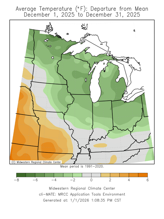
Been a 8 years since the sub as whole has seen a colder Dec.
-
Damn. What a classic look to score around here in January. We actually do decent with well-defined SWFE looks like this. I dig it
-

2025-2026 ENSO
40/70 Benchmark replied to 40/70 Benchmark's topic in Weather Forecasting and Discussion
I wouldn't be a surprised to see a day or three like that, but I don't think that will be representative of the majority of the month. -
January 2026 regional war/obs/disco thread
ORH_wxman replied to Baroclinic Zone's topic in New England
In everyone’s defense, these waves are pretty weak sauce. Not much upside. The 1/6 wave has the most upside imho if it can maintain enough integrity…better antecedent airmass too. But even that one prob has upside of like 3-5” and the reality is likely significantly less than that. Im more interested in the post-1/10 pattern evolution. Been a lot of variance on that. -
January 2026 regional war/obs/disco thread
weatherwiz replied to Baroclinic Zone's topic in New England
somehow I feel like that energy back in the SW ~7th is holding back on the potential for the wave to amplify a bit more -
January 2026 regional war/obs/disco thread
40/70 Benchmark replied to Baroclinic Zone's topic in New England
I did't get that from the post of his that I agree with, but figured maybe there was another one that I didn't see. -
January 2026 regional war/obs/disco thread
WinterWolf replied to Baroclinic Zone's topic in New England
Really… on January 1st…what’s happening to you Ken? Does the back creak on July 1st? And no, I’m not glass full or overflowing all the time either. Looks like we have a couple threats to track again…I’ll enjoy whatever snow we can get. Long way to go…winter only officially 10 days old..back in great shape. And when we get the thaw, to whatever degree it comes with here, we will enjoy the nicer temps for a little reprieve. -

12/31-1/1 Possible Snow Showers/Squalls to Start 2026
MillvilleWx replied to bncho's topic in Mid Atlantic
Got woken up to the squalls moving through early this morning. Absolutely smoked. Shook the house. The snow coated everything in an inch of its life. A great start to 2026 imo. Kudos to the hi-res that were on this potential from 36-48 hrs out. This was a strong axis of PVA coupled with impressive PBL dynamics. One thing I learned many years ago with talking to Bernie Rayno at the AMS Conference in Phoenix in 2015, while drinking and nerding out over winter weather….fresh injections of Arctic air tend to bring fresh coatings of white in their paths. This was no different. Happy to see all the cool reports and for some of these pics out of Western MD depicting a winter wonderland @nj2va Happy New Year everyone. Let’s bring home a good winter after a solid start for most.