All Activity
- Past hour
-

Rise of the Machines: January 18-19 Winter Storm Obs Thread
WinterWolf replied to WxWatcher007's topic in New England
Ya, it’s been nice and steady….eyeballing about the same here. -
98% of the sub would agree with you.
-

January 18th Back Door NW Trend Snow OBS Thread
Ralph Wiggum replied to Mikeymac5306's topic in Philadelphia Region
Some backbuilding happening in Upper Bucks as per radar loop. Hrrr looks decent for wave 2...this is 4pm depiction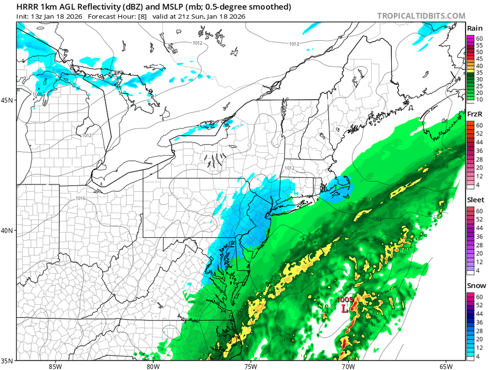
-
This is the second January in a row that they have gotten snow. Last January they got about 5 inches in some areas.
-
Radar is quite impressive in a band in GA centered from Albany/Tifton to Dublin to Augusta.
-
What could go wrong?
-
Congratulations to the GA peeps. Just a cold rain here.
-
It appears per radar that Augusta might be about to get hit hard with something! Yeah, I am 20 miles north of Augusta and it is finally changing over to snow.
-

Pittsburgh/Western PA WINTER ‘25/‘26
Ahoff replied to Burghblizz's topic in Upstate New York/Pennsylvania
Even with a warm tongue potential. That would be coming after some seriously cold weather, correct. It's hard to scour out cold air, I thought anyway. Maybe it hangs on a bit longer before warm air over runs it. -

Storm potential January 17th-18th
Kjtc1979 replied to WeatherGeek2025's topic in New York City Metro
Please be safe. -
Cold chasing moisture never works out. (Except in southern GA I guess) Congrats ya'll!!
-
The models just failed horribly within hours of this event. I am not about to get on board with a 200 hour storm signal.
-

Winter 2025-26 Medium/Long Range Discussion
Geoboy645 replied to michsnowfreak's topic in Lakes/Ohio Valley
Meanwhile here around Madison, we just had one of most localized snowfall events we have had in a while. The original forecast for Friday into Saturday was 1-2" Friday morning and then another Friday night. Instead we had a localized Fgen(?) band setup Friday night over the I-94 corridor and just sit for about 18 hours. With some occasionally heavy rates of 1-1.5" of an hour, Madison ended up recording 5" of snow on 1/16 and 5.6 on 1/17, although the snow depth doesn't quite represent that because of settling.. This was a very dry and fluffy snow too, so we could have localized ground blizzard like conditions tomorrow with the cold blast. Thing is, this band was not much wider than Dane County. I have some snow up here, but like 3-4" not 6+. And if you go N to Portage or S to Janesville they may have like 2-3 OTG. This honestly feels like a summer MCS that forms and doesn't move and dumps 5-6" of rain in a night, but just snow instead. -
Colder
-

Jan 17-18 Sunday Funday Storm
Leesville Wx Hawk replied to NorthHillsWx's topic in Southeastern States
Yep, looks like Eric was right after all. -
A lot of happy people on LI with a bit more snow than what was prognosticated. Recent winters were the complete opposite. currently on the taconic. Not good
-
Get used to it. The precip hole has been here for a couple decades and has steadily gotten worse. That each and every model, which seemingly cannot agree on anything, now all show it for each and every event - even in the long range - is infuriating. But, it's not the models; they are correct. It's something that has happened to the climate. We don't get gulf storms anymore, and we don't seem to get juicy OHV lows either. And any coastal that forms are always too far east for us.
-
FWIW, the CMCE, GEFS, EPS, and the EPS-AI all show DC with a mean of 6+" of snow
-
RDU went up a degree in the past hour. We are definitely cooked. Congrats to the GA folks.
-

Rise of the Machines: January 18-19 Winter Storm Obs Thread
dendrite replied to WxWatcher007's topic in New England
22.6° -SN -
Biggest winner so far: 3” at Monticello, GA!0908 AM SNOW MONTICELLO 33.30N 83.68W 01/18/2026 M3.0 INCH JASPER GA BROADCAST MEDIA REPORT FROM MEDIA OF 3 INCHES OF SNOW IN MONTICELLO.
-

Rise of the Machines: January 18-19 Winter Storm Obs Thread
Sey-Mour Snow replied to WxWatcher007's topic in New England
1.2” so far .. as expected morning snow overperforming -

Storm potential January 17th-18th
RU848789 replied to WeatherGeek2025's topic in New York City Metro
As of 9 am, 1.2" new snow at 32F. Looks like another 30-40 minutes of snow to go for this first round as per the radar. Not sure how long the lull will last, but if the HRRR model is to be believed, we won't get much snow from about 10 am to 2 pm, after which snow should pick up again through early evening. -

Rise of the Machines: January 18-19 Winter Storm Obs Thread
SouthCoastMA replied to WxWatcher007's topic in New England
Starting to stick everywhere now..coating -
bit of a bust forecast - in a GOOD way - mets only had the city down for a trace from this storm 3 days back.......
.thumb.jpeg.f5c6ba9d911ec96b3b124f8606aee58e.jpeg)


