All Activity
- Past hour
-
Lack of sunshine also leads to other issues such as mildews, various plant and lawn fungus, garden issues, plant blights, etc., and seasonal depression issues for some. Its so old now, I rather have sun and a heat versus a swamp and no sun for weeks. Far less sun versus clouds the last 90 days.
-
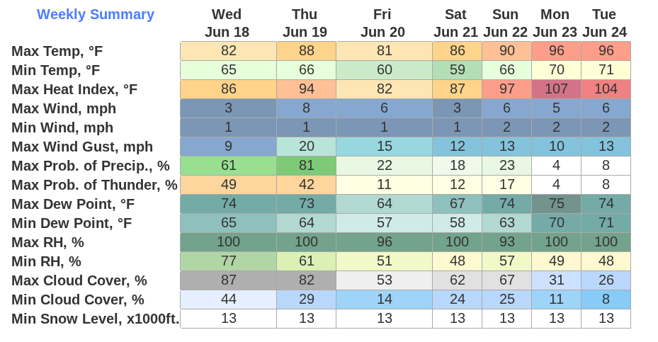
This is gonna suck, isn’t it? I don’t think I’ve ever seen a temp/DP combo quite like 96/75
-
I haven't had a chance to review all the posts last 4 hours, but from my vantage point. THREE 100 deg days in June is still a possibility INLAND NJ-NYS/CT, BUT, same caveats as yesterday... pattern isobars show quite a bit of weakness so its easier to Seabreeze early in the season, plus T STORM cloud cover debris is unknown. (not sure how EC spreads 100 so far inland across LI/NYC next week and so I have to expect some tempering of those excessive projections in the weekend updates). I think 00z/18 GFS MEX MOS is wayyy too cool on daytimes for KEWR but its something to keep in mind. Thursday max at KEWR is my decision break point on any 100 degree thread for next week that would possibly issue Thursday evening. I've no plans to thread tomorrows fairly widespread severe wind potential along I95. Am pretty sure we'll see a a nw flow MCS - iso severe in NY metro early Sunday morning as the warm front returns. My KEWR 90 degree days are Thu, possibly both Sat/Sun, certainly Mon-Wed and then maybe again Thu and Sat of next week with 3 100's possibly??? embedded between Mon-Sat of next week. SVR potential in slow moving deluges wherever sea breezes intersect next Mon-Tue (if not capped). Noticed besides the 2-4K J ML Cape early next week- there are rather large 7H-5H lapse rates. IF something goes, would be microburst w hail/wind/ flooding...thats IFFFF.
-

2025 summer max contest -- enter by 06z June 20
gopper replied to Roger Smith's topic in Mid Atlantic
DCA: 103 IAD: 102 BWI: 102 RIC: 102 -
Yesterday's plains convection drove this system well south of the model forecast. It's a big bust for many locations across Iowa. I'm at least getting one more decent batch of general rain this morning. We are getting into late June, but we are still waiting for our first good thunderstorm. The vast majority of our rain this spring has been the stratiform type with little to no thunder.
-
The 6Z Euro AI likes NJ for the 100 degree heat.
-
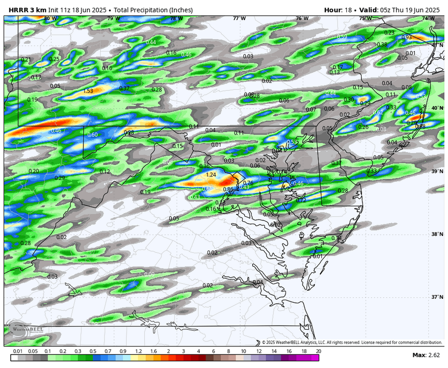
.65 since last night. More scattered thunderstorms today. WB 11Z HRRR
-
70 / 68 clouds (day 5 hour 108). Should see some breaks and with the sun temps spike low to upper 80s in the hot spots. Storms later this evening along the boundary as the warm front comes north further. Tomorrow a shade hottter than today and again pending on clouds some get their first or next (2nd/ or 3rd) 90 degree reading. Friday drier transition day before the heat builds in Satruday. Euro keeps the mini MCS into New England Sat night into Sunday and the GFS gets rain here Saturday night and lingering debris clouds Sunday keeping the rainy weekend consecutive streak hope alive for those few hoping for more rain. 850 MB temps are >18c Sunday and then >21C Mon - Wed , peak heat Mon - Wed, Tue the century mark most probable. We'll see if the wind / flow keep the N/W component and how hot it'll be. Looking like starting tomorrow 8 of 10 90 degree days to close the month in the hot spots / wamrest scenario otherwise 5-7 of the next 10. In the way beyond Beyond there heights look elevated with ridging into the EC with an overall warm - hot but continued wet look.
-
The Euro and CMC both have 100° heat away from the sea breeze Monday through Wednesday. They don’t have the upper low to the east like the GFS shows with its stronger onshore flow. But I agree that NJ will probably see the greatest 100° potential heat next week away from the sea breeze influence.
-
Oh I would too . But at some point something has to give . The five finger boredom death punch the last 5 years is enough to make you gouge eyes out with a grapefruit spoon
-
Today should see some breaks in the aftn with temps 75-80. It won't be that bad.
-
Congrats Florida on the repeat. They kept the cup in USA!
-
I've seen a few of those this year around the house.
-

2025 summer max contest -- enter by 06z June 20
PrinceFrederickWx replied to Roger Smith's topic in Mid Atlantic
If edits are still allowed, I'd like to adjust up one degree at each airport: DCA: 98 IAD: 97 BWI: 98 RIC:98 -
I'd rather take my chances with a cane.
-
Picked up 0.37" from several rounds of showers and thundershowers yesterday, nothing severe. What we DO have is crazy humidity and mugginess, yuck. 2004 has saved me from setting new record 'warm minimums' last three mornings, but I've been within 1 to 1.5 degrees of that each morning. Currently cloudy and 67.8/66.5 at 8 am.
-
We may have more chances through the 11-15 day as the heat tries to tickle.
-
I'm thinking the same thing.
-
We'll see if 100+ can be reached. I think central NJ will still hit it but it'll be more difficult now. I can see us falling just short, will still be very uncomfortable regardless
-

Central PA Summer 2025
Mount Joy Snowman replied to Voyager's topic in Upstate New York/Pennsylvania
MDT record highs for 6/23-6/25 are 97, 98, 98. I tend to think there will be a bit too much moisture in the ground for the surface level to break those marks but it could be close. We shall see. -
woke up to fog/mist. Mod rn while driving to the gym. Didn't see that in the frcst
-
2" on the nose from two rounds last night. Saw the classic trampoline in the middle of a farm field on the way to work this morning. Pretty solid storm.
-
Early AM dog walk with a DP of 71, soupy and misty.
-
Just for once , please bring the goods, the damage , the excitement, the destruction. Just once, it’s not too much to ask
-
.20 rain last night here.


