All Activity
- Past hour
-

Spooky Season (October Disco Thread)
WxWatcher007 replied to Prismshine Productions's topic in New England
Low of 28.7 here at WXW1 -
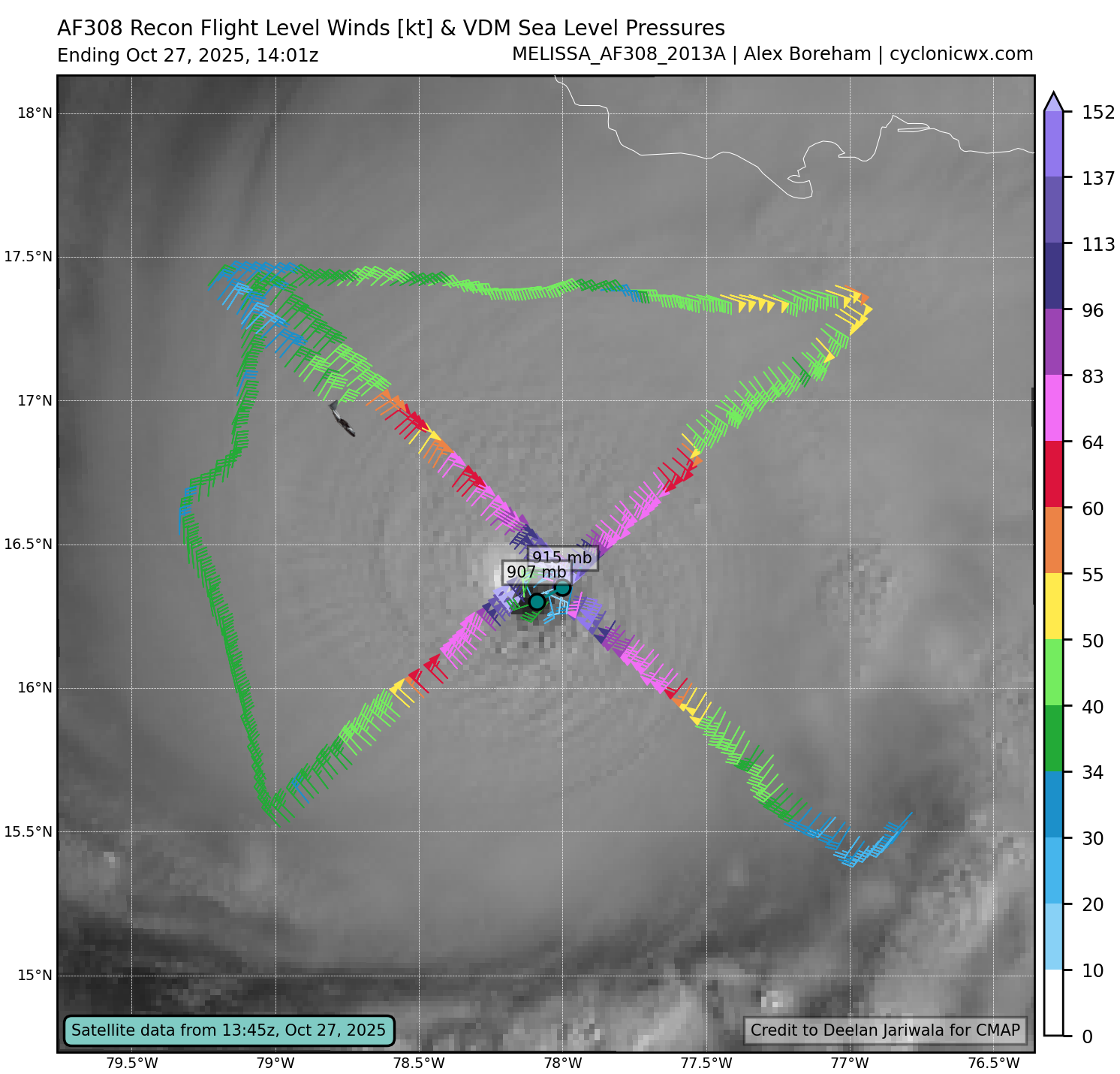
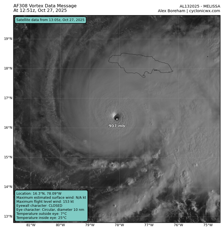
Adjusted to 907mb
-
You should be getting lots of rain today.
-
It's not 907 mb. The latest recon passes found ~914 mb.
-
That’s the nature of a solid +PNA as you know, especially without an accompanying -EPO. There has been a pretty strong +EPO in recent days. Often the coldest anomalies on average tend to be further SE with it often above normal in much of Canada. As the Euro Weeklies show, I also expect a warmup after the next 2 weeks. But, in the meantime, as mentioned the E 1/4 of the US is overall progged to have its coldest 10/27-11/9 since 2012 with coldest anomalies centered southern Mid-Atlantic states and SE US. Per the EW, a warmup follows but mainly to near normal rather than AN with only week 4 AN and it only slightly AN.
-
Goodbye mini drought
-
Driving from Marion to Asheville was white knuckle for sure. Bad accident in Buncombe and a sheet of water coming down Old Fort mountain. Each time they pave the interstate and redo the center barrier. it does nothing to help with drainage. One of the worst places to hydroplane in the middle of a curve coming down a steep mountain...
-
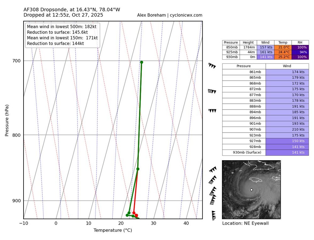
907mb
-
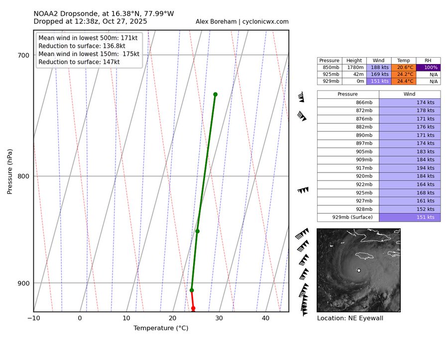
WOW!!! Between passes, gusts go from 194kts to 210kts. In the more recent dropsonde, notice how the temperature and dewpoint lines zigzag at the bottom. This means the dropsonde rotated and touched all 4 quads of the eye. Melissa is in extremely rare air, officially the 3rd highest gusts ever recorded by recon hunters.
-

2025-2026 ENSO
PhiEaglesfan712 replied to 40/70 Benchmark's topic in Weather Forecasting and Discussion
2017-18 and January 2022 are the only times really that the coastal areas got good snow since the mid-2010s el nino. But 2009-10 to 2015-16 (if you take out 2011-12 and 2012-13) was a great run: 2009-2010 0.0 0.0 0.0 0.0 0.0 12.6 8.9 36.6 T 0.0 0.0 0.0 58.1 2010-2011 0.0 0.0 0.0 0.0 0.0 20.9 13.4 3.7 T 0.0 0.0 0.0 38.0 2013-2014 0.0 0.0 0.0 0.0 T 3.3 18.8 6.1 15.6 T 0.0 0.0 43.8 2014-2015 0.0 0.0 0.0 0.0 T 0.4 4.8 9.8 7.4 0.0 0.0 0.0 22.4 2015-2016 0.0 0.0 0.0 0.0 0.0 0.0 16.7 3.9 5.1 1.8 0.0 0.0 27.5 -
Like most of these turns North, it will likely stall, wobble, and then start drifting North before accelerating.
-
 Lately I've been looking at HDD data for overall sensible cold. By this method January 2025 was 4th coldest January of this century. However, not the case with full year, June-July. Here's our coldest years: These number look about right to me, and 2002-2003 is 4th coldest all time for Balto, (since 1872)
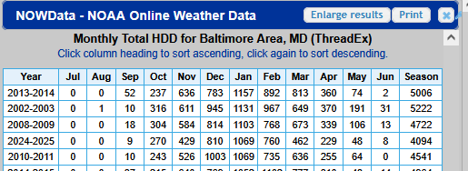
-
As others have said, Melissa is currently moving South of due West again.
-
29 here, patchy frost. Another beautiful day on tap.
-
No it wasn’t prior to 2018-2019. Maybe since you live west of I-95 you are unfamiliar with the coastal areas. We had numerous events prior to 2018-2019 which were all or mostly snow. That mid-October storm track would have been mostly rain or mixed near the coastal plain during the winter. Too many storms to count prior to 2018-2019 which were the opposite.
-
Come on baby. Keep pushing west. Fingers crossed for Jamaica.
-
I can count on one hand where the area's he mentioned get all snow from a coastal. It is pretty rare. You are correct with what you originally said.
-
(002).thumb.png.6e3d9d46bca5fe41aab7a74871dd8af8.png)
Central PA Fall Discussions and Obs
ChescoWx replied to ChescoWx's topic in Upstate New York/Pennsylvania
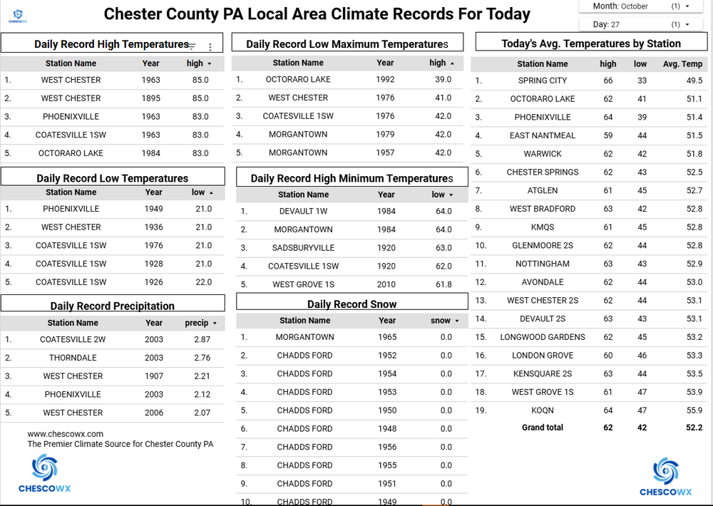
Some lower spots across the area saw lows in the 20's with Warwick the chilliest spot at 26.4 degrees. Here just a few miles south of there the low was almost 12 degrees warmer at 38.2. We should continue with below normal temperatures for at least the next week. The big weather story will be the beneficial rainstorm that looks likely to arrive by Wednesday evening and continue into Friday morning before clearing out in time for the trick or treaters on Halloween. This could be our most significant general rain event since the end of July. Some models are showing as much as 2 inches for many areas.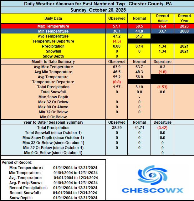
-
E PA/NJ/DE Autumn 2025 Obs/Discussion
ChescoWx replied to PhiEaglesfan712's topic in Philadelphia Region
Thanks Mike! Great info!! -

E PA/NJ/DE Autumn 2025 Obs/Discussion
MGorse replied to PhiEaglesfan712's topic in Philadelphia Region
Bottomed out at 33.2F just before 6 AM. Observed some frost. - Today
-
28. Had to scrape the windshield this morning for the first time.
-
Some brief windows for snowmaking after the rain end of the week, but not consistent. If the mid month mild up happens then its looking a lot like last year for the Thanksgiving weekend faithful. I'm sure killington and sunday river will find a way to get open at least the weekend before while everyone else is scrambling!
-
He is banking on a weak PV just like other forecasters. It should be interesting to see if we actually go into a neutral state or a stronger LA Nina.
-
It’s coming near the tail end of a -NAO period which began around the 15th. Not really sure how to define a classic -NAO since there have been many versions over the years with blocking near Greenland. It’s just that during the 2020s we are finding more ways for higher latitude blocking to merge with the subtropical ridge especially at storm time.