All Activity
- Past hour
-

September 2025 OBS-Discussion centered NYC subforum
forkyfork replied to wdrag's topic in New York City Metro
i wonder if smoke will be an issue for daytime convection and our best rain comes with the better lift tonight -
I was thinking Bristol to Moultonborough so yeah…same wavelength.
-
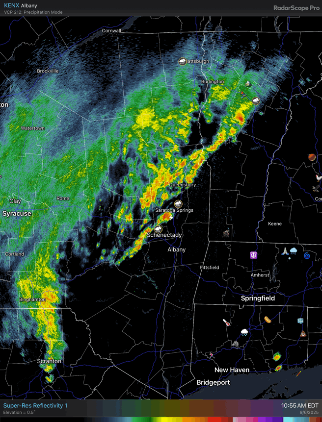
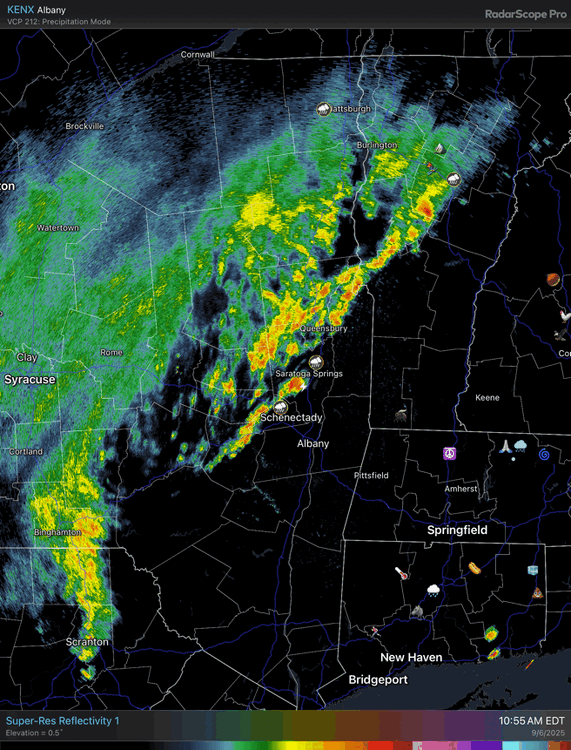
Looks like the first wave got some of north central PA and into Scranton and the Endless Mountain region. Now watch. Wave #2 will form southeast of I-81 and hammer Lancaster, Reading, the Lehigh Valley, and points east and south. Just like every opportunity before it.
-
12z HRRR
-

Saturday 9/6 Strong/Severe storm potential
Chrisrotary12 replied to Torch Tiger's topic in New England
Feel like I’m too far east. -
Saturday 9/6 Strong/Severe storm potential
Chrisrotary12 replied to Torch Tiger's topic in New England
Bridgewater, NH feels like the play today. Always the lake sunapee region in NH. -
81/74
-
Thankfully not downtown, just inside the beltway.
-
Man it’s warm out. Drenched. Love it.
-

September 2025 OBS-Discussion centered NYC subforum
uofmiami replied to wdrag's topic in New York City Metro
GFS has you covered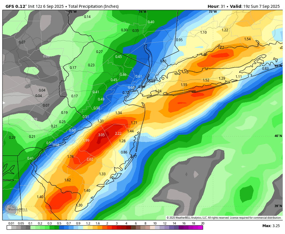
-
Yeah that’s a little strange. Maybe they have it on clear air mode?
-
76/68 she comin’…probably a 2-5pm window for here.
-
Clearing sort of peeling north through most of SNH.

-

September 2025 OBS-Discussion centered NYC subforum
RU848789 replied to wdrag's topic in New York City Metro
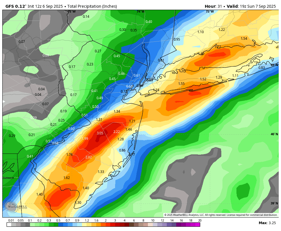
Yeah, our key time, a few miles south of Philly is 4-5 pm when the outdoor ceremony was planned (after that it's all indoors) and while the HRRR is showing precip holding off down here (and for 95 up through CNJ) until about 6 pm, the 12Z NAM and RGEM, so far, are showing at least 0.1-0.2" from 2-5 pm (presumably mostly closer to 5 pm), which would be a mess for an outdoor wedding that ends at 5 pm. Tough call, but we've already decided to move the ceremony indoors, which has the bonus of getting a bunch of people over 55 out of the heat and humidity. Thanks, as always, for your expertise. -
Saturday 9/6 Strong/Severe storm potential
Chrisrotary12 replied to Torch Tiger's topic in New England
Soupy 18 holes this morning. Any chance we clear out before initiation? -
With 91L kaput we will likely reach the historical peak of hurricane season (9/10-9/11) with no named storm in the Atlantic Basin. ACE season to date is now below normal. We're at 39 and normal is 47. Erin is responsible for 32 of those 39 ACE points. We're wasting peak season at this point so we're going to have some catching up to do if we want to get to normal which is 122. It still can be done though so we'll have to see what mid September into October can pull off. MJO forecast to go into more favorable phases by then but we've been playing a bit of kick the can on that so remains to be seen. Gut tells me watch out for something to lift out of the Caribbean toward the Gulf coast before all is said and done. I think if there is going to be a Major hit on the U.S. coastline this season it will be the gulf coast. Chances of an east major hit this season are low and decreasing for several reasons. Not expecting anything to get named over the next 5-7 days.
-
Oh so close to the first 30s low of the season. 40.5 degrees.
-

September 2025 OBS-Discussion centered NYC subforum
anthonymm replied to wdrag's topic in New York City Metro
October will have some sultry days/nights. -

Saturday 9/6 Strong/Severe storm potential
Torch Tiger replied to Torch Tiger's topic in New England
womp womp
-
Said this yesterday. The plug has been pulled.
-
We haven’t turned ours on yet, the house has been staying around 65-67 with the windows closed and lows in the mid 40s down here. Natural gas fireplace has been flipped on though.
-
39 here this morning again.
-
ECM is now incapable of seeing below normal temps. It blowtorches everything >30 days out by default now. Garbage warm biased model
-
We moved to Fort Kent on Jan 1, 1976 and moved back south (Gardiner) on Oct 25, 1985, so I missed the big Novie dump, though we waded thru it a week later on Public Land (Scraggly Lake) just NE from Baxter Park. The day we moved to FK was relatively mild, low 20s. Then Jan 9-13 had minima -33/-36/-24/-41/-37. 1976 was probably the most weather-eventful year of my lifetime, though the 12 months March 1960-Feb 1961 was close.
-
What’s up with all the radar returns going on right now? I know birds and other animals can cause reflections but I’ve never seen widespread yellow reflections from that.