All Activity
- Past hour
-
Already surpassed yesterday’s 6z RGEM that @snowman19 had as his pick for the model that represented the most likely outcome. Speaking of which.. where is snowman? Enjoying the storm, I hope
-
Per latest it's down to 979 mb and it's not moving! Here's last 3 updates
-

"Don’t do it" 2026 Blizzard obs, updates and pictures.
WxWatcher007 replied to Ginx snewx's topic in New England
Love seeing heavy echoes redevelop and rotate into CT from the SE. Rates are down to -SN here but growth is very good. Get that SE stuff up here and we're really in business. -
My buddy's kid is in town from Houston for an interview up in NYC on Wednesday. He started bitching about a headache and coming down with a bug before his big interview. Had to reassure him with my station barometer that we just watched pressure fall through the floor since breakfast.
-
Just going to say it halted progress this looks like the pivot
-
Jeebus the wind. This storm means business.
-
.thumb.png.4150b06c63a21f61052e47a612bf1818.png)
"Don’t do it" 2026 Blizzard obs, updates and pictures.
HIPPYVALLEY replied to Ginx snewx's topic in New England
I’m not sure we see anything over 16”-18” anywhere in New England. -
Accu forecast is 10 to 14 for me in Montgomery city. Pa. Have 7 now.
-

"Don’t do it" 2026 Blizzard obs, updates and pictures.
ineedsnow replied to Ginx snewx's topic in New England
LFG!!! -

Blizzard of 2026 Storm Thread/OBS
Kevin Reilly replied to Mikeymac5306's topic in Philadelphia Region
Looks like that band has come to a halt at the Blue Route in Delaware County I’m missing it by 1.3 miles. However I have moderate snow 7.8” wind is 15-25 basically -
Radar looks ok but it’s just light snow ATM
-
It's pouring here now.
-
I have seen 5 inches of compact wet snow in March 2018 when New Brunswick had a foot and it’s not far from me. If the rates aren’t high enough it can settle and melt; so a foot can fall but you won’t have it otg. That seagull guy is a licensed coast guard charter captain and knows his weather. His life depends on it.
-

Blizzard of 2026 Storm Thread/OBS
Prairie Dog replied to Mikeymac5306's topic in Philadelphia Region
8 to 12 for me and I just hit 8 -
Are you sure it is not from the brews earlier? just kidding...feel better
-
It's 12:18 AM EST
-
Semi official report from Battery Park was 4.9 at 9, and I doubt they had 3/hour through 11, so...
-
2/23 4z HRRR Noon monday
-

Feb 22nd/23rd "There's no way..." Obs Thread
AlexD1990 replied to Maestrobjwa's topic in Mid Atlantic
This is without a doubt the worst storm I have experienced since 2010. Whiteout conditions currently. Couldn't even take video or pictures. Impossible to measure what's accumulated, but easily over 8-10" so far. Winds continue to howl. Can hear cracking trees in the distance. Snow accumulating on vertical surfaces. -
Southern MD / Lower Eastern Shore weather discussion
AlexD1990 replied to PrinceFrederickWx's topic in Mid Atlantic
46,000 without power in DE, the majority in Sussex County. It's holding here for now, but frequent flickering and dimming.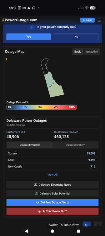
-
Finally the long sought-after IVT Snowband. Hope you guys get smashed with a lot of snows!
-
I had to pull my elderly parents out of Seaside and they’re staying with me, keeping an eye on them and staying ahead of the shoveling - I’ll likely be up all night. Haven’t had much time to enjoy the storm or track / catch up here, but family first of course. Wife has been a tremendous help and a trooper because my parents are a lot a lot. My sister lived in the area but moved to the southeast this past year on little notice, so I’ve been their primary caretaker since. Makes snow a bit less fun sadly, double house duty at a minimum.
-
Regional Weather Roundup National Weather Service New York NY 1200 AM EST MON FEB 23 2026 Note: "FAIR" indicates few or no clouds below 12,000 feet with no significant weather and/or obstructions to visibility. NYZ071-072-176-178-NJZ106-104-230600- New York City Metro Area CITY SKY/WX TMP DP RH WIND PRES REMARKS Central Park SNOW 30 29 96 N15G32 29.67F VSB 1/4 WCI 19 World Trd Ctr NOT AVBL Bronx Lehman C N/A 32 32 100 N18G30 N/A WCI 20 LaGuardia Arpt SNOW 31 30 96 N25G38 29.65F VSB 1/2 WCI 17 Queens College N/A 32 30 93 N24G43 N/A WCI 19 Kennedy Intl SNOW 31 30 96 N29G47 29.61F VSB 1/2 WCI 16 Breezy Point N/A N/A N/A N/A N26G36 N/A Brooklyn Coll N/A 32 32 100 N21G39 N/A WCI 20 Staten Island N/A 32 32 100 N21G38 N/A WCI 20 Newark/Liberty HVY SNOW 31 29 92 N28G40 29.66F VSB 1/4 WCI 17 Teterboro HVY SNOW 30 28 92 N24G36 29.67F VSB 1/4 WCI 16 $$ NYZ177-179-078>081-230600- Long Island New York CITY SKY/WX TMP DP RH WIND PRES REMARKS Jones Beach N/A 32 N/A N/A N37G47 N/A WCI 16 Wantagh N/A 32 32 100 N22G36 N/A WCI 19 Hempstead NOT AVBL Matinecock Pt N/A 32 N/A N/A N33G41 N/A WCI 17 Farmingdale SNOW 31 29 92 N23G45 29.58F VSB 1/2 WCI 18 MacArthur/ISP SNOW 31 29 92 N33G47 29.58F VSB 1/2 WCI 15 Stony Brook N/A 32 32 100 N10G26 N/A WCI 24 Shirley FOG 31 31 100 NE15G41 29.58F VSB 3/4 WCI 20 Mt Sinai Harb N/A N/A N/A N/A N24G35 N/A Westhampton LGT SNOW 31 30 96 NE31G49 29.58F VSB 3/4 WCI 16 East Hampton LGT SNOW 32 29 90 NE16G26 29.59F WCI 21 Southold N/A 32 32 100 NE25 N/A WCI 19 Montauk N/A 33 31 92 NE20G38 29.61F WCI 21 $$ NYZ052-065-067-230600- Hudson Valley CITY SKY/WX TMP DP RH WIND PRES REMARKS White Plains SNOW 30 26 85 N16G31 29.66F VSB 1/2 WCI 19 Larchmont Harb N/A N/A N/A N/A N28G36 N/A Croton On Huds N/A N/A N/A N/A N9G16 N/A Somers N/A 30 28 93 N8G20 N/A WCI 23 Brewster N/A 30 28 93 N12 N/A WCI 21 Newburgh SNOW 28 28 100 N18 29.75F VSB 1/2 WCI 16 Montgomery CLOUDY 30 26 85 N17 29.74F FOG WCI 18 Otisville N/A 30 28 93 NE8G20 N/A WCI 23 Warwick N/A 30 28 93 N10 N/A WCI 21 Suffern N/A 30 28 93 N13 N/A WCI 20 Poughkeepsie SNOW 30 28 92 N12 29.77F WCI 20 Albany LGT SNOW 29 26 89 N7 29.90F FOG WCI 22 $$ NJZ001-105-106-008-010-013-015-019>022-104-230600- New Jersey CITY SKY/WX TMP DP RH WIND PRES REMARKS Newark/Liberty HVY SNOW 31 29 92 N28G40 29.66F VSB 1/4 WCI 17 Teterboro HVY SNOW 30 28 92 N24G36 29.67F VSB 1/4 WCI 16 Caldwell LGT SNOW 30 28 92 NE9G24 29.70F VSB 3/4 WCI 22 Somerville SNOW 31 28 89 N10G24 29.68F VSB 1/2 WCI 22 Linden LGT SNOW 31 29 91 NE17G24 29.67F VSB 3/4 WCI 20 Perth Amboy N/A N/A N/A N/A N22G30 N/A Sussex LGT SNOW 30 25 81 N13G25 29.73F VSB 1 WCI 20 Andover N/A 29 25 85 N7G20 29.71F WCI 22 Trenton FOG 30 28 92 N20G32 29.65F VSB 3/4 WCI 17 Millville LGT SNOW 30 30 100 N23G37 29.56F VSB 3/4 WCI 17 Atlantic City LGT SNOW 31 29 92 N28G46 29.47 VSB 3/4 WCI 17 Wrightstown NOT AVBL Toms River LGT SNOW 31 30 96 N23G33 29.55F FOG WCI 18 Belmar LGT SNOW 31 N/A N/A N22G35 29.56F VSB 1 WCI 18 $$ PAZ047>061-062-071-230600- Eastern Pennsylvania CITY SKY/WX TMP DP RH WIND PRES REMARKS Philadelphia LGT SNOW 32 30 92 N21G30 29.67F VSB 3/4 WCI 20 Allentown NOT AVBL Scranton LGT SNOW 28 26 92 N7 29.76F FOG WCI 21 $$ CTZ002-004>006-009-010-012-RIZ004-006-007-MAZ004-011-015-230600- Southern New England In CT CITY SKY/WX TMP DP RH WIND PRES REMARKS Bradley Intl LGT SNOW 29 28 96 N21G30 29.79F VSB 3/4 WCI 16 Hartford SNOW 30 30 100 N14 29.76F VSB 1/2 WCI 19 Danbury LGT SNOW 31 26 82 N14G24 N/A VSB 1 WCI 21 Wtrbury/Oxford SNOW 28 27 96 N20G29 29.69F VSB 1/2 WCI 15 Norwalk Harbor N/A N/A N/A N/A N25G31 N/A Bridgeport LGT SNOW 31 30 96 N21G33 29.67F VSB 3/4 WCI 18 Meriden SNOW 30 30 100 N15G29 29.73F VSB 1/2 WCI 19 New Haven LGT SNOW 31 28 89 N20G30 29.67F VSB 1 WCI 19 Chester LGT SNOW 32 32 100 NE15G21 29.66F WCI 22 Groton LGT SNOW 32 28 85 NE26G40 29.66F FOG WCI 18 Willimantic SNOW 31 29 92 NE16G28 29.75F VSB 1/2 WCI 20 In RI CITY SKY/WX TMP DP RH WIND PRES REMARKS Providence LGT SNOW 32 31 96 NE18 29.75F FOG WCI 20 Block Island LGT SNOW 31 30 96 NE28G44 29.62F VSB 3/4 WCI 17 Westerly LGT SNOW 32 30 92 NE14G31 29.66F FOG WCI 22 In MA CITY SKY/WX TMP DP RH WIND PRES REMARKS Boston FLURRIES 34 26 72 NE28 29.85 WCI 21 Worcester HVY SNOW 27 26 96 NE16G28 29.77F VSB 1/4 WCI 15 Westfield LGT SNOW 29 28 96 N15 29.81F VSB 1 WCI 18 Provincetown FLURRIES 35 29 78 E17G31 29.81F WCI 25 Nantucket CLOUDY 33 32 96 E22G44 29.66F FOG WCI 21 $$
-
I can assure you that Im not "tripping." I don't discount your measurements, as I have several employees near one of my job sites near north ocean city. They are reporting nearly a foot as well, near you. I report what I have, and others have in my specific area. Dynamic storms tend to perform this way.
-
Buddy in Mt. Laurel up to 9.2" at mid-night. Holding steady at 30 degrees.