All Activity
- Past hour
-
The bad thing about the CMC is it follows that ice w/ near record cold.
-
Its an odd duck H5 wise but gets us into snow by this time period
-
Extrapolate out and would have been a close call whether it went east vs west of apps with the warm nose
-

January 2026 Medium/Long Range Discussion
NorthArlington101 replied to snowfan's topic in Mid Atlantic

-
Looks like a lot more icy solutions on the GEFS as well so far
-
CMC is north with the Snow
-

January 2026 regional war/obs/disco thread
Sey-Mour Snow replied to Baroclinic Zone's topic in New England
cmc major snowstorm hartford to dc 10-20” -

E PA/NJ/DE Winter 2025-26 Obs/Discussion
Albedoman replied to LVblizzard's topic in Philadelphia Region
Let it hone in Ralph. I said many weeks ago what was going to happen around MLK and dam if it did. Nearly a foot of snow on the ground at my house. Now comes the blistering cold that you will will remember I stated back last Novmeber which I go lambasted for. The storm for this weekend is going to flip flop until the PAC data comes into play by Thursday afternoon. Anything on the mid range models is horse shit IMHO, the models are all are missing vital data. Fun storm to track but if th cold is as deep as shown for thweekend, supression will likley win out. Snow in the teens will be nasty as even salt will not work should be the big headline. Travell could be SOB. Be prepared to huncker down this weekend would be motto if the storm comes north. Personally another 4-6 inches is good enough for me but blowing that shit at 12 degrees is not fun. -
This is a completely different animal imo. Last year the signal was loud but also obvious early on that anyone further east than the mid south was hoping for strung out northern energy to pay dividends. None of that bs this time! This from an analog standpoint is 100% how you get a memorable significant impact from the plains to the eastern seaboard.
-

January 2026 Short/Medium Range Thread
fountainguy97 replied to John1122's topic in Tennessee Valley
UK is a beauty. Big tick south Update: it is also going to be a blood bath of ice for ETN -
Ukmet will not be as far north as its 0z run. Still ejects the SW but doesn't phase it as far back so should be better for all of us.
-

Storm potential January 17th-18th
winterwx21 replied to WeatherGeek2025's topic in New York City Metro
After getting 6 inches of snow from the three rounds this weekend, I'm up to 18.5" for the winter. We're well on our way to our first above average snowfall winter in quite awhile. -
19 degrees colder in Chattanooga at 132 compared to 6z for the AIGFS and 15 degrees colder at TRI.
-
The lighter ICON is worse to me..lighter precipitation plus colder surface...easier for to accumulate on powerlines.
-
for such little snow their is a ridiculous amount of salt on the sidewalks and the street every time a big truck goes on by a mist of salt follows..
-

Winter 2025-26 Medium/Long Range Discussion
Chicago Storm replied to michsnowfreak's topic in Lakes/Ohio Valley
the GEM (and RGEM to an extent) over-do cold temperatures, sometimes significantly so. -
Obviously that's extreme lol but feast/famine or storms in bunches has historically how we roll in the MA. We're conditioned to expect fail (especially the last 10 years or so) but we also haven't had a blocked pattern like this since 2011. I'm personally expecting a second legit threat at least over the next 2 weeks. Blocking cycles like this have historically lasted 30-45 days. Imo, it would be much less likely for things to fall apart quickly than hang around and deliver. I had a hunch this winter would be blocky and so far it has been pretty good in that department. The upcoming period looks ideal. Just need things to remain active to capitalize. That piece is always random and chaotic but give us enough chances and we'll do just fine imo.
-
Ukmet ejecting wave like cmc. Let’s see where it goes.
-
Is there a Weenie Rule that these storms tend to get juicer QPF as we get closer to the event... If we can hold and get into NAM range it might get ridic
-
Low key had a lot of 1995 analogs pop when I did my seasonal for the office this winter. It was strong enough that I've got a wager going for a 20+" seasonal here. Doesn't mean we're getting the nutty 50+ that season had, but not at all surprising that this stuff is starting to pop off now that WPac warm pool forcing is strengthening and Nina forcing is waning.
-
No way dude, you could literally be across the street from me for all i know!
-
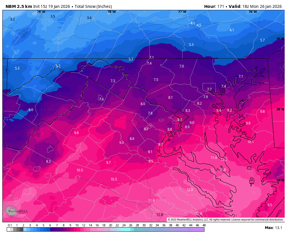
January 2026 Medium/Long Range Discussion
NorthArlington101 replied to snowfan's topic in Mid Atlantic
Also the NBM is… well, folks-y. 9” mean for DC. -
Side note: the aurora may be visible on the horizon tonight. NOAA SWPC has a G4 Watch for tonight-tomorrow AM. New moon and clear sky should offer a good viewing opportunity if you're willing to find a dark sky and freeze outside.
-
Oh dang. The 12z AIGFS did correct southward by quite a bit.
-

Winter 2025-26 Medium/Long Range Discussion
A-L-E-K replied to michsnowfreak's topic in Lakes/Ohio Valley
let's ride it


.thumb.jpeg.f5c6ba9d911ec96b3b124f8606aee58e.jpeg)