All Activity
- Past hour
-
Yep. I highly doubt northern westchester gets an inch of snow
-
Stop looking at the f*cking NAM.
-

26th-27th event, coming at us like a wounded duck.
Baroclinic Zone replied to Go Kart Mozart's topic in New England
You could see the changes early on at 5h NAM. Consolidate that s/w and punches into that cold air dome more.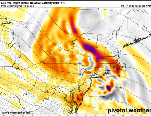
-

Boxing Night Snow/Sleet/Ice Dec 26-27 Storm Thread/Obs.
LVblizzard replied to Mikeymac5306's topic in Philadelphia Region
Starting as graupel in Allentown. -
Screw models at this point. Follow radar trends, look out the window. It's real/now time...
-

26th-27th event, coming at us like a wounded duck.
CoastalWx replied to Go Kart Mozart's topic in New England
3K nearing half inch QPF on the shore south of BOS. We pray. -

Snow Potential Dec 26-27
coastalplainsnowman replied to WeatherGeek2025's topic in New York City Metro
sorry about that -

Boxing Night Snow/Sleet/Ice Dec 26-27 Storm Thread/Obs.
Fields27 replied to Mikeymac5306's topic in Philadelphia Region
Sleet off the rip in Reading. Sent from my SM-S938U using Tapatalk -
The NAM is already wrong in northern PA
-

Boxing Night Snow/Sleet/Ice Dec 26-27 Storm Thread/Obs.
systemfreeze64 replied to Mikeymac5306's topic in Philadelphia Region
Also seeing a light wintry mix here in Allentown now -

26th-27th event, coming at us like a wounded duck.
EastonSN+ replied to Go Kart Mozart's topic in New England
Updated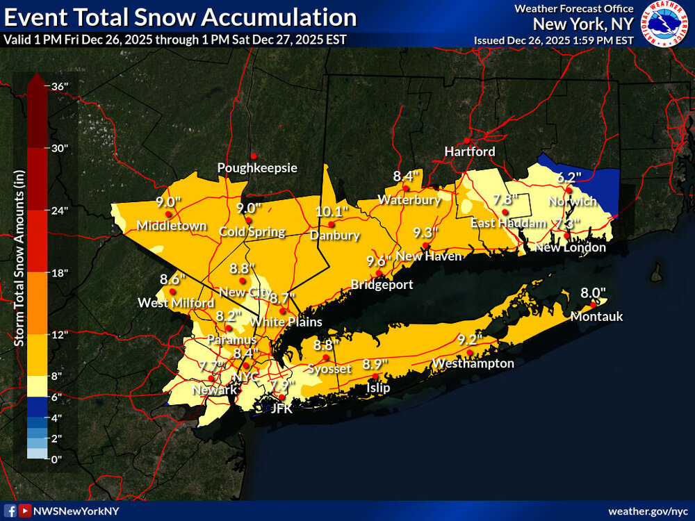
-

26th-27th event, coming at us like a wounded duck.
weatherwiz replied to Go Kart Mozart's topic in New England
I wouldn't be surprised if many ends as a little sleet or freezing drizzle but cut those 18z QPF totals down a bit -

Boxing Night Snow/Sleet/Ice Dec 26-27 Storm Thread/Obs.
Ralph Wiggum replied to Mikeymac5306's topic in Philadelphia Region
Snow/sleet.mix just started in Telford 26F -

26th-27th event, coming at us like a wounded duck.
bristolri_wx replied to Go Kart Mozart's topic in New England
NAM 3K looks similar in coverage but less snow overall. -
3k Nam is better
.thumb.png.ebd90f2473be2eaf6266430194699f17.png)
-

Mid to long range discussion- 2025
WinstonSalemArlington replied to wncsnow's topic in Southeastern States
-
Apologies; just saw this. .
-

26th-27th event, coming at us like a wounded duck.
CT Rain replied to Go Kart Mozart's topic in New England
I can't speak for other markets but at least in Hartford-New Haven I think the average TV forecast is typically more conservative than the NWS and also more frequently correct. -
They need a snowstorm protocol to put into effect; not everything requires State of Emergency declarations. There’s a reason the boy who cried wolf has guided civilization for millennia. .
-

Snow Potential Dec 26-27
Winterweatherlover replied to WeatherGeek2025's topic in New York City Metro
This is the worst case scenario, it's unlikely but it's been right with warm tounges before. Honestly im more worried about mixing in the in NYC and even the LHV than eastern LI in this setup so the NAM scenario wouldnt entirely shock me. -
22F/8DP. That's going to eat up at least the initial part of it. Radar looks a little spotty, not a lot of concentrated heavier precip currently. I'm leaning towards the 5 on the 5-8" forecast.
-

Central PA Winter 25/26 Discussion and Obs
pawatch replied to MAG5035's topic in Upstate New York/Pennsylvania
25 degrees, DP 10 and some stray sleet. -
Agreed my friend Just keep in mind that with blocking, anything is possible
-
LoL Nam
.thumb.png.47f4716a1accbfea16448b4f121cbed2.png)
-
Much of NE NJ, NYC, and Long Island: ▪Total Snowfall: 5 to 9” likely, locally 11” possible. Highest amounts more likely across northern sections of NYC/NJ metro and central and eastern LI. Sleet may briefly mix in for areas south of I78 in NJ and south shore of NYC and western LI this evening. ▪Timing: Light snow may start as early as 3pm. Heavy snowfall between 6pm and 2am. Light snow late tonight into Saturday morning, tapering off by midday. ▪Peak Snowfall Rates: 1-2”/hrlikely for a 2-5 hrperiod between 6pm and 2am. Rates could briefly exceed 2”/hr, particularly across central-eastern LI. ▪Temperatures/Snow Character: Upper 20s to lower 30s. A dry and powdery snow to start, likely becoming wetter through the night. ▪Impacts: Difficult travel from intense snowfall rates, snow-covered roads and visibilities reduced down to ¼ mile at times, particularly between 6pm and 2am. Isolated downed tree branches and power outages possible due to snow load.


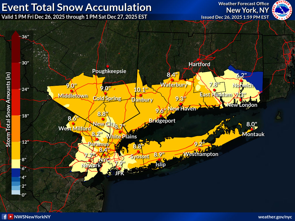

.png.a9d848b6210517ba4de48b3b703a7e93.png)


.png.f91d52e7ebe7b3bf470dcadd6d57375e.png)
