All Activity
- Past hour
-
.thumb.jpg.6a4895b2a43f87359e4e7d04a6fa0d14.jpg)
Central PA Summer 2026 Discussion/Obs Thread
Yardstickgozinya replied to Voyager's topic in Upstate New York/Pennsylvania
I believe it might have been confirmed. this afternoon, not one hundred percent sure If it's your tornado though. -

2026 Atlantic Hurricane Season
vortex95 replied to Stormchaserchuck1's topic in Tropical Headquarters
Ginger in 1971 is one of the oddest TC tracks and second-long lasting TC in the Atlantic on record. https://en.wikipedia.org/wiki/Hurricane_Ginger The "Yankee" hurricane in 1935 started near Bermuda and ended up hitting MIA from the ENE! https://en.wikipedia.org/wiki/1935_Yankee_hurricane For the oddest track globally?, Typhoon Wayne in the NW Pacific in 1986 takes the cake here! https://en.wikipedia.org/wiki/Typhoon_Wayne_(1986) -
Nailed this one tonight:
-
Indiana, PA just surpassed us in yearly rain tallies. We are at 38.40. They are now 38.76. By year's end many places in the East and south will be several feet over us, while south central Texas will be getting wall to wall sunshine and highs in the 80s, even in December. We'll see a few sprinkles maybe some drizzle. We have been leading most places most of the year so far. Those days are OVER. It's not hard to understand. We are too far west for this Record El Nino. So we will be bone dry and warm. The Nino is so east-based it is setting records. The Plume is also way too far east for us. What else is new.
-

2026-2027 Record-breaking El Nino
jaxjagman replied to Stormchaserchuck1's topic in Weather Forecasting and Discussion
Never has there been a -PDO AT the end of August in a strong NinoWhile analogs if you find one in which i doubt you will at least ATM look like 1982 not 1997 and especially 2015.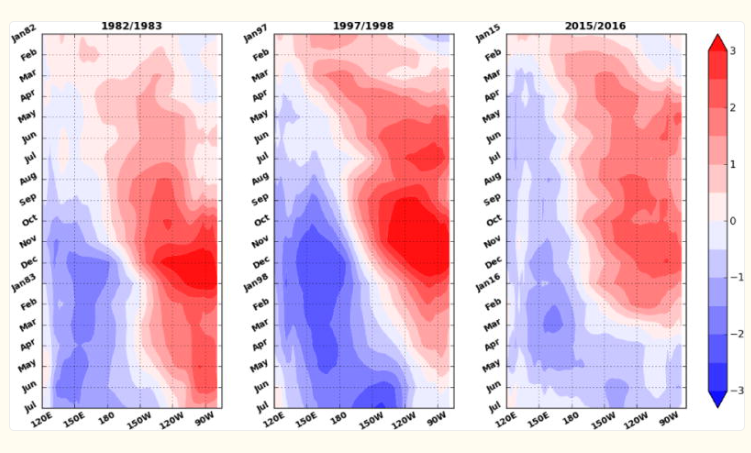
-
Hit 97 here, 96 at MLI. More mid 90s tomorrow but back in the 80s for Sun/Mon before more 90s next week.
-
2026 Atlantic Hurricane Season
vortex95 replied to Stormchaserchuck1's topic in Tropical Headquarters
The CONUS has no major hurricane landfalls Nov 2005 to July 2017, that 11.5 year gap is the longest on record going back to 1851. New England or LI has not had a hurricane landfall since 1991, it's longest such gap period on record. Contrast this to 5 from 1938-1960. During the Atlantic inactive period 1970-1994, there were 3 hurricane landfalls in this same region, but 1995-2025 is the most active Atlantic period on record, and none here! So you see it works in bursts and in non-even/linear ways, and this is true worldwide w/ many wx phenomena. This why you can not let short-term cycles/trends (say 30 year or less) or "recency bias" influence scientific objectivity. Human quirks and fallacies in perception/behavior are an issue here as to reality (and the MSM takes full advantage of this, unfortunately). Geologically, the atmosphere cycles/patterns work on much longer time scales. What is a "long time" to people (say 10-20 years) is not a long time geologically! In the case of Atlantic TC cycles, they work on a 25-50 cycle from the AMO phase. This is clearly evident in the data going back to the mid-19tn century. And of all the TC basins in the world, the Atlantic is the most variable overall. -
You should post that over in the main Enso thread. You're sure to make lots of friends.
-
lmao at that 00z 4knam.
-
UVA Sunset after a convective complex rolled through.



-
EF-2 tracking 3.5 miles. 1 man was injured trying to protect this newborn from a falling tree, but fortunately no fatalities.
-
 http://quickph.com/# legal online pharmacy
 -
Grand total of 0.01” here
-

Fall 2026 Med/Long range discussion
SchaumburgStormer replied to Brian D's topic in Lakes/Ohio Valley
Like, I was only half speaking in jest when I said winter cancel. Looking forward to that February golf. -
A spectacular cell started falling apart on its way to me, as usual. Still managed 0.42" but places not far north have 1.5"+. Hopefully some more tomorrow.
-
Looks fake but I hate that we are now in a timeline we can’t tell
-
It has been confirmed
-
reputable mexican pharmacy: MexiPh ~ mexico prescription online
-

2026-2027 Record-breaking El Nino
Ephesians2 replied to Stormchaserchuck1's topic in Weather Forecasting and Discussion
Not sure what you mean. It's part of the -PDO that has been around for years and was why 2023-24 was so weird. Hopefully we see that warm blob actually break down into the fall. -
I was really surprised when this popped up on my Radarscope. The HRRR hates this event, and while WPC talked up the 850 mb confluence, it seems kind of subtle to me. That said, the RRFS likes it to some extent, as did some of the cams earlier today, and storms are indeed firing across central PA. I'll be surprised if anything makes it southwest of Baltimore, but it's worth monitoring for a while this evening.
-
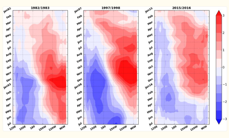
Really unigue pattern we are in,weve never seen the PDO negative after August in a strong NINO so like @Jeff said above the PDO is out of whack.Just like imto 1982 the solar is just as well on the decline,but regardless,this could end up like 1982 and NINA domt really develop until the fall,winter possibly next year,unlike 1997 or 2015,but i still discount 2015 myself because that NINO started in 2014 and the Walker Circulation broke down into summer and made this a west/ central based NINO,unlike this year
-
Didn’t get as hot as yesterday, but still extreme. 100.5 was the high
- Today
-
Typical Baz type game.
-
High of 94. One more day of this heatwave. Sunday and Monday look magnificent. Low 80's and hopefully low dew points.
-
WPC just issued a meso for heavy rain for central and NE MD with a nearly clean sweep on radar?