All Activity
- Past hour
-
 AIFS remain south, though...at this point we gotta trust them more than then the EPS.
 -

February 2026 OBS & Discussion
CPcantmeasuresnow replied to Stormlover74's topic in New York City Metro
Albany is colder, by several degrees, and snowier than Boston. I don't think most people around Boston, or Albany for that matter, would call March spring. I've lived in the HV for many years at elevation 600 feet, which is about mean elevation for most of the HV and I barely call April Spring. Everyone sees things differently I guess. -
The mean temperature here since December 1 (12/1 - 2/9) has been 30.4° The mean for the past 18 days has been 20.0°
-
Noticeable melting today and it’s not even sunny out
-

Is we back? February discussion thread
Damage In Tolland replied to mahk_webstah's topic in New England
That’s what we mentioned. It’s very much alive -
One more degree and I hit 50, currently 49.1/31.8 at 1:45 pm. Those 60's from Roanoke south look to try and make a run this way??
-
Let’s relive this
-
Amazingly, the EPS still has quite a few members that are hitting us for the 16th. I am not buying it but it is not completely out of left field if that system tries to make a comeback…it’s still far enough out that it could.
-

Is we back? February discussion thread
codfishsnowman replied to mahk_webstah's topic in New England
Bid 31 and its not even mid February.....I haven't seen those kind of readings since February 2015! -

Pittsburgh/Western PA WINTER ‘25/‘26
colonel717 replied to Burghblizz's topic in Upstate New York/Pennsylvania
The good news is nothing on horizon for next 10-15 days. Should be nice slow snow melt so no floods. Then wait to see if we have one last gasp of winter. I was out grilling for lunch. Nice to smell burgers cooking on the grill. Spring right around the corner. -

Is we back? February discussion thread
40/70 Benchmark replied to mahk_webstah's topic in New England
All northern stream. -

February 2026 Medium/ Long Range Discussion: 150K Salary Needed to Post
Ji replied to Weather Will's topic in Mid Atlantic
the ensembles are still north of the OP. Should be interesting. models will have a hard time with the timing of the ejecting low vs the northern stream. Keep hope alive. Where is cape? -
I'm not sure what you consider "damn cold." But average highs are in the 40s beginning around the first of March. Snow typically doesn't linger long, except during unseasonably cold periods. Maybe compared to NJ you remember it as having been cold, but climatologically/typically spring comes relatively quickly near sea level all the way up the Hudson Valley in March.
-

Pittsburgh/Western PA WINTER ‘25/‘26
TimB replied to Burghblizz's topic in Upstate New York/Pennsylvania
Off the top of my head, I can come up with a 14F to 76F swing from the morning of 3/29/22 to the afternoon of 3/30/22. -
WinterWolf right now

-
.thumb.jpg.6a4895b2a43f87359e4e7d04a6fa0d14.jpg)
Central PA Winter 25/26 Discussion and Obs
Yardstickgozinya replied to MAG5035's topic in Upstate New York/Pennsylvania
The sun wasn't even close to coming up when I had posted this but it was all, but maybe thirty minutes after I posted that everything completely dissipated. NWS did mention in their forecast discussion that very little snow was reaching the ground from that first wave. -
Is we back? February discussion thread
codfishsnowman replied to mahk_webstah's topic in New England
Don't do it for something that pedestrian. It can get way way way worse. -
Is we back? February discussion thread
40/70 Benchmark replied to mahk_webstah's topic in New England
The EURO sends the MJO more onto the COD, whereas other guidance enters the MC....going to do a write up soon about the favored option. -
No. No. No. It’s a cold and snowy run bro. That’s tenor.
-
We’re the most difficult metro area in the Megalopolis to forecast in the winter by far. Every storm type can nail us or totally shaft us. The storm types that frequently nail Boston and it’s clear 3-4 days out can slam us, scrape or screw us. Same for the big Miller As that hit DC/Baltimore.
-

February 2026 OBS & Discussion
North and West replied to Stormlover74's topic in New York City Metro
It’s been dry the past few years. . -
I think we're definitely going to be introducing PAC air into much of the country but that doesn't mean we can't or won't snow nor does it mean we can get colder weather at times. The upcoming pattern though looks a bit volatile and active so there is that. I don't want to say we're looking at a gradient pattern but something along those lines is definitely possible. It seems there is higher confidence in how the Pacific evolves (though guidance has struggled with this) with lower confidence in the evolution of the Arctic which may be tied into the models toying around with SSW potential.
-
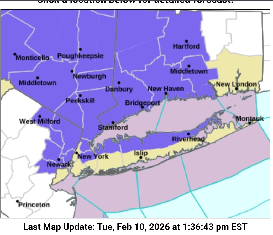
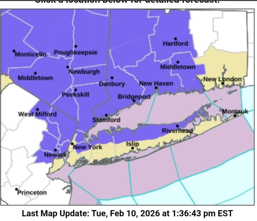
WWA for areas a little further south now
-
February 2026 OBS & Discussion
North and West replied to Stormlover74's topic in New York City Metro
aren’t you ready for the Mets? . -