All Activity
- Past hour
-
 Notables for this month: The entry into the Solar Minimum, ~ the 8th, a period of tepid insolation that last through ~ Feb 9. During that time, the sun loses only small amount of latitude through Solstice, after which, it gains a small amount through the first week of Feb. Veterans Day on November 11 Then of course there's Thanks Giving ( Giggidy for lucky folk ). Climate: Novembers used to dependable. They would begin rather obviously autumn-like, then by natural progression ... perhaps even ending in either a winter-like regime or seeming about to do so. However, ... particularly since the climate never started changing and was instead an alternate AGW hoaxed reality crafted by The Pentaverate Left Wing conspiracy some 20 years ago ... these eerily excessive warmth periods began occurring. WTF, right? Because, "for no other reason other than natural cycles" , massive variability just happens... And so, Novembers as hugely chaotic could be apropos, but we'll just have to wait until HAARP stops executing the instructions from the Pizza Gate command cadre... - In the end, we'll just have to suffer November craziness - This year is no different ... The Pacific is split during the first 10 or so days of month in the available prognostic methods ( index monitoring/model 'cadence' ..etc). The western side of Pacific hemisphere is dominated by a strong +WPO index, which is also being undercut by a rather robust right -RMM MJO progression from phase 3 through 6. Those two are in a constructive interference... a warm signal should be convincing. However, that warm single is not sending a wave pattern as the eastern Pacific and North America are currently being influenced by a flat +PNA, with terminating -NAO exersion over the eastern continent. The operational model runs have been vacillating between a progressive modestly climate cool, to modestly warm layouts, probably being effected by the aforementioned conflict.
 -
.thumb.png.4150b06c63a21f61052e47a612bf1818.png)
Spooky Season (October Disco Thread)
HIPPYVALLEY replied to Prismshine Productions's topic in New England
Euro has a pretty good coastal Tuesday, GFS and CMC not so much. -

Spooky Season (October Disco Thread)
WxWatcher007 replied to Prismshine Productions's topic in New England
Same, though I started around mid-month. I’ve had 4 freezes this month and several other nights in the mid 30s. I’m considering getting a wood stove for my living room to warm the house and reduce my gas usage this winter. -
I think the biggest issue is the record strong -IOD event ongoing. Just posted on this earlier. That is definitely going to have global consequences in how the forcing goes, December in particular. You aren’t going to have an event this strong and not effect the tropical forcing patterns, especially in the early part of met winter
-

Spooky Season (October Disco Thread)
UnitedWx replied to Prismshine Productions's topic in New England
It will be great for an area like that. I'm in the middle of a major basement remodel where I ripped out a '50s rec room so I can insulate everything properly, and then ultimately put back the rec room to look just like it did back then. I have been considering a small pellet stove for the area since it works so well upstairs -
The recent cool down has yielded a max daily departure of only -4 to -6 one day.
-
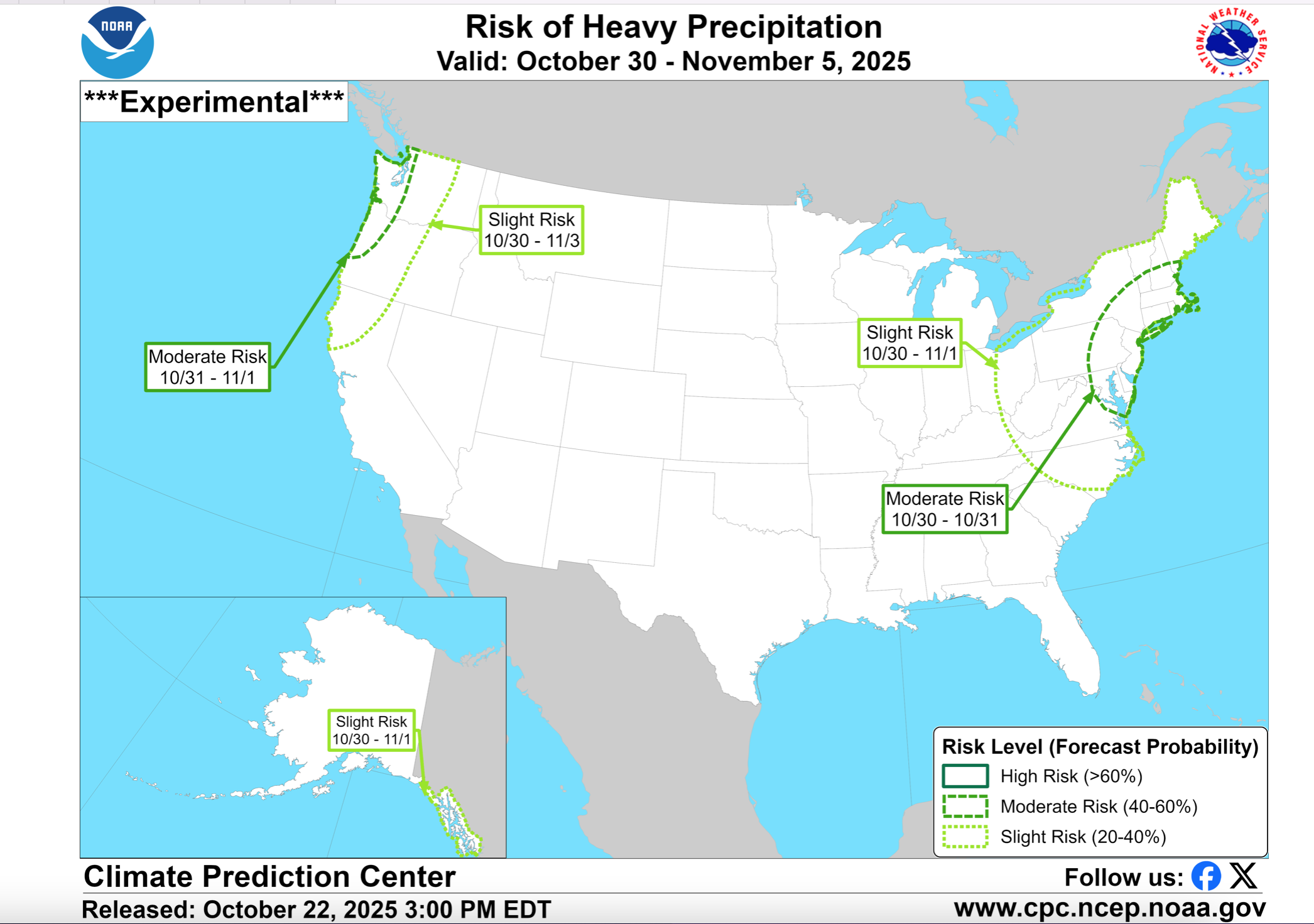
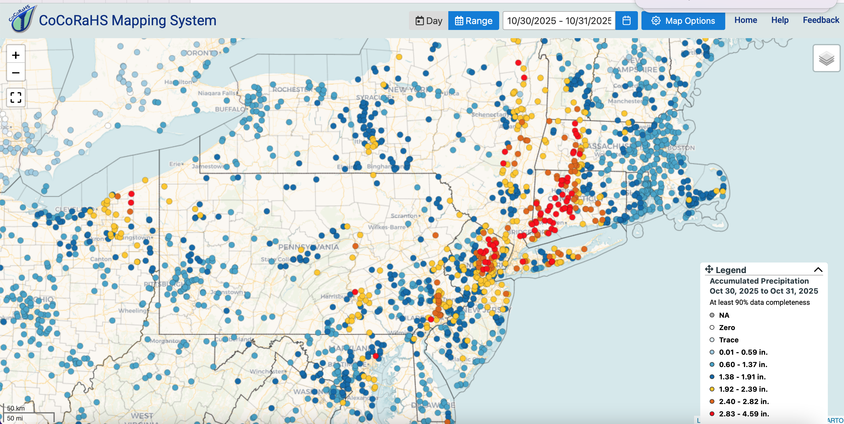
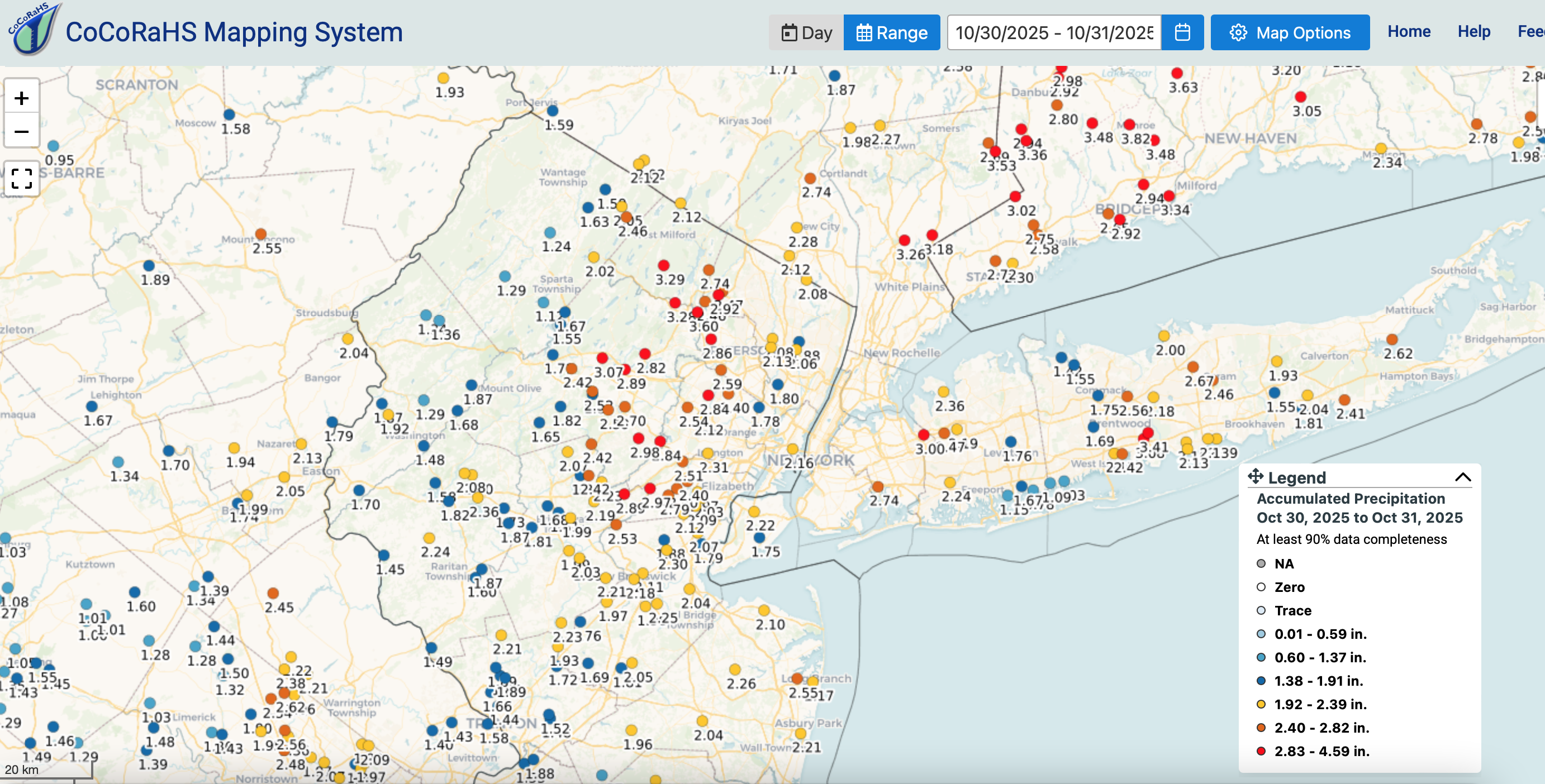
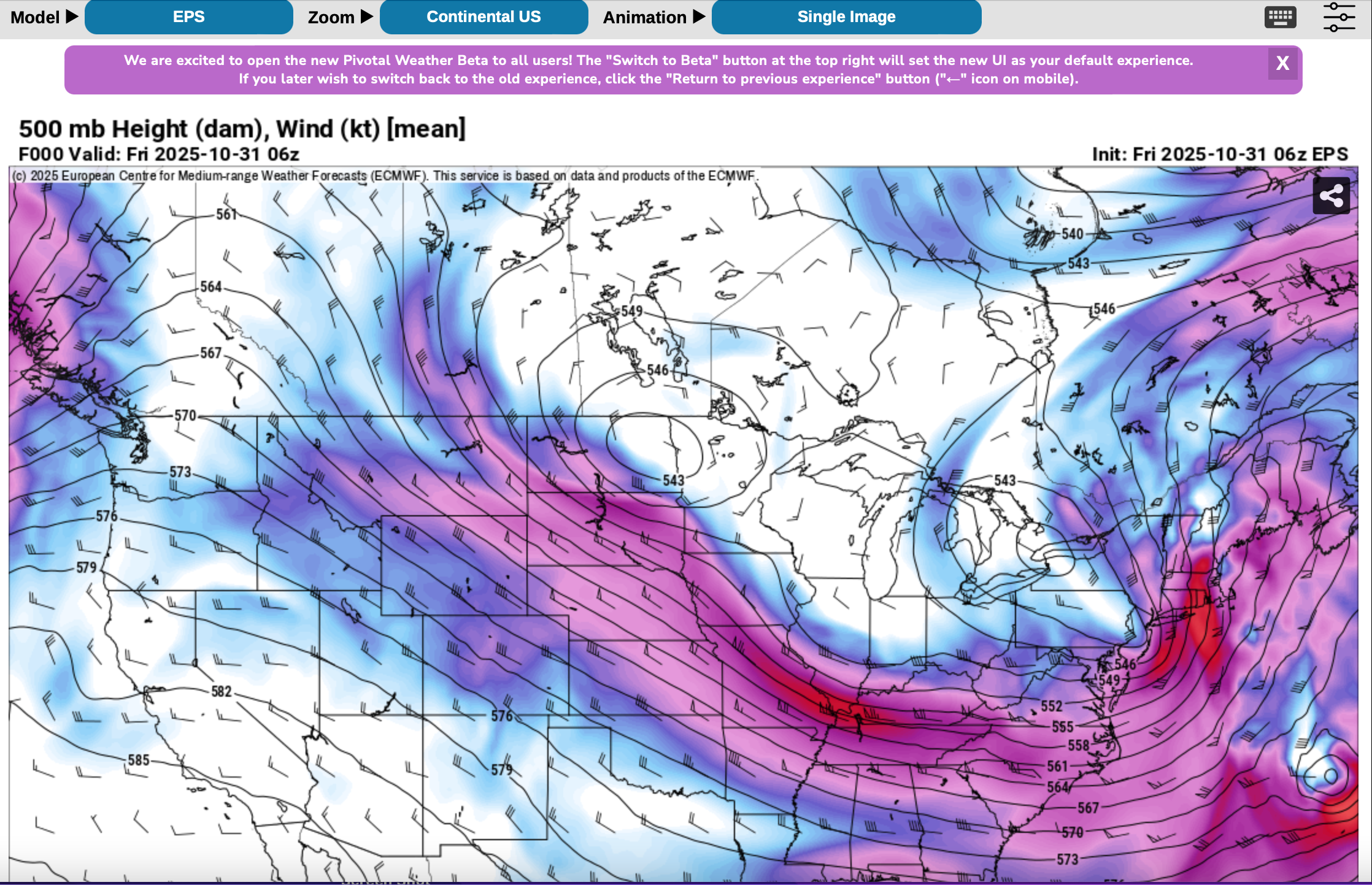
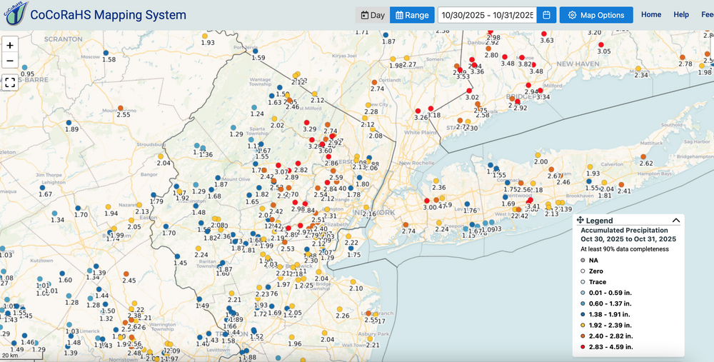
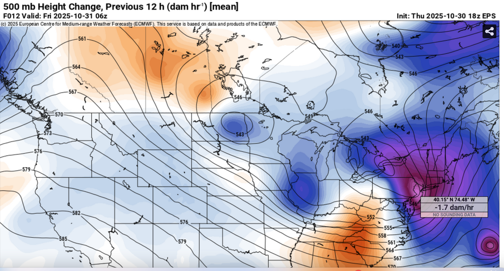
 Summary message: I could not go back to review the OHP between 16z-20z/30 for the unfortunate fatalities related to only very short fuse prediction of 1" in 15 minutes over NYC... results as cellar fatalities, again, as in prior city FF. That's the part that didnt work out in the thread. Otherwise see graphics below 1) CPC D8 1"+ heavy rain forecast (MDT risk) 2) CoCoRaHs region red and orange dot verification of the main axis of heavy rain (see legend) 3) NYC subforum rainfall 4) EPS 06z/31 5H... note negative tilt lobe to NJ 5) EPS 18z/30 12 hr 170M HFC over NJ... large 12 hr HFC's need to be contended with as event concerns...given adequate moisture. You can use these graphics to go back to p1 of this thread to verify the Sunday 10/26 post. Modeling was helpful for sure. GEFS rainfall and max gusts were terrible as compared to the EPS and EPSAI modeling.
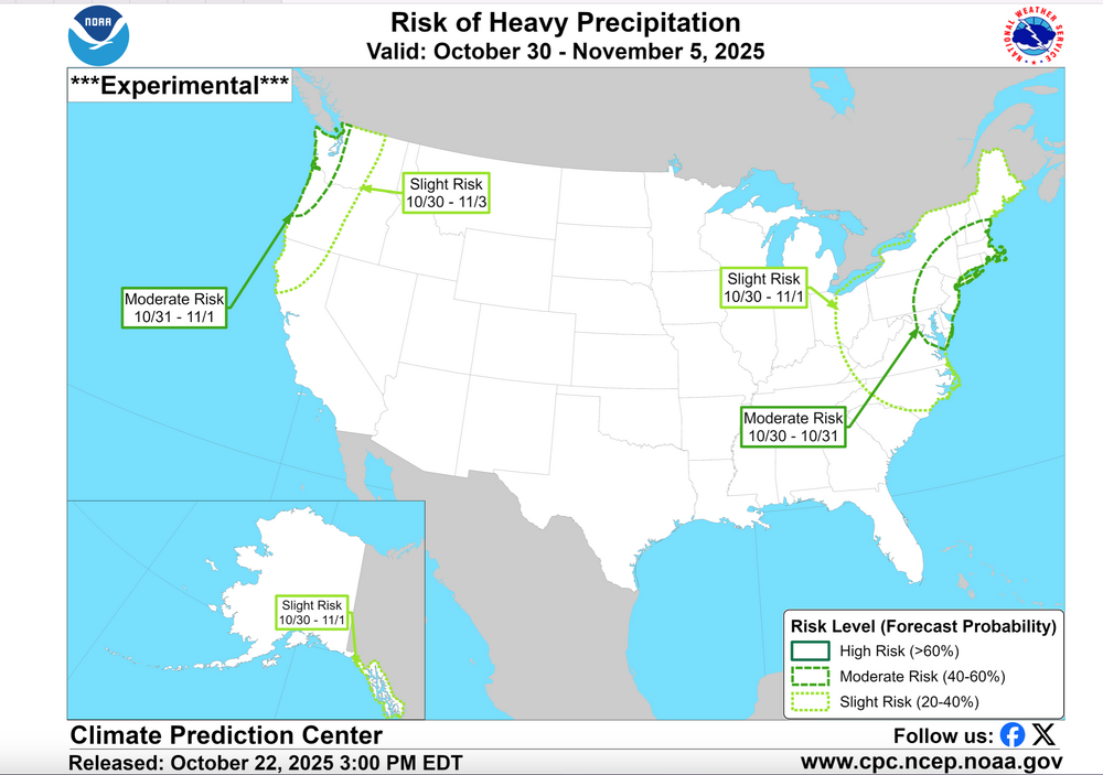


-

Spooky Season (October Disco Thread)
DavisStraight replied to Prismshine Productions's topic in New England
I have mine in a walkout unheated basement so it's the only heat there. I guess some heat will rise to the main floor but it's mainly to keep the basement warm where my office is located. -
A year ago we had record warmth with hights in the low - mid 80s.
-
the park is wrong 100% of the time with temps, someone needs to pin that already.
-
Spooky Season (October Disco Thread)
UnitedWx replied to Prismshine Productions's topic in New England
We LOVE ours. It's in the living room fireplace, and due to the design of our house the heat is able to circulate through the entire first floor. Second floor stays cool... but we prefer it like that. I had thought that running it mid winter would help lower the gas bill, but it did not. The cost of that many pellets and the gas easily exceeded the cost of just running the natural gas furnace. It is much more economical for us to just use it in between seasons and occasionally for a little extra warmth or ambiance in the living room. -

Central PA Fall Discussions and Obs
canderson replied to ChescoWx's topic in Upstate New York/Pennsylvania
Neighbor is getting a roof done today. Ummmmmmm ok. We every Halloween go to our friends who have a little girl. We do their candy so they can take her around. They get like 400 kids, it’s awesome. Tonight will be pretty miserable unfortunately -
Records: Highs: EWR: 83 (2024) NYC: 81 (1946/2024) LGA: 83 (2024) JFK: 78 (2024) Lows: EWR: 29 (1975) NYC: 29 (1925) LGA: 33 (1975) JFK: 30 (1966) Historical: 1846 - Eighty-seven pioneers were trapped by early snows in the Sierra Nevada Mountains that piled five feet deep, with 30 to 40 foot drifts. Just 47 persons survived the "Donner Pass Tragedy". (The Weather Channel) 1884: Brownsville, TX reported 15.71 inches of rain for the month, nearly five times normal. (Ref. AccWeather Weather History) 1887: Weather records have been kept at Charlotte, NC since 1878. The only snow ever to occur there in October happened on this date. (Ref. AccWeather Weather History) 1899: A Caribbean hurricane crossed Cuba then moved north and made landfall at the North Carolina/South Carolina border. The hurricane became extra-tropical in Virginia, then curved across southeast Pennsylvania and moved into New England and the Canadian Maritimes. The highest wind gusts were measured to 84 mph at Cape Henry, VA, 82 mph at the Delaware Breakwater, DE and 60 mph at Norfolk, VA. (Ref. Wilson Weather History) Richmond had 1.71 inches of rain on this date in 1899. (Ref. Richmond Weather Records - KRIC) 1925: Record low October temperature readings were set from northern New England down to the Mid-Atlantic to the Ohio Valley. Record lows included: Van Buren, ME: 1°, Garfield, VT: 2°, Pittsburg, NH: 4°, Houghton Lake, MI: 7, International Falls, MN: 12, Peoria, IL: 14, Rockford, IL: 14, Madison, WI: 16, Alpena, MI: 17, Burlington, VT: 17°, Syracuse, NY: 20°, Flint, MI: 20, South Bend, IN: 20-Tied, Dubuque, IA: 25-Tied, Allentown, PA: 22°, Avoca, PA: 22°, Springfield, IL: 22, Rochester, NY: 23°, Fort Wayne, IN: 23, Indianapolis, IN: 24, Buffalo, NY: 25°, Grand Rapids, MI: 25, Wilmington, DE: 25°-Tied and New York (Central Park), NY: 29°-Tied. (Ref. Wilson Weather History) (Ref. AccWeather Weather History) 1950 - Unseasonably warm weather prevailed in the central U.S. for Halloween. The temperature soared to 83 degrees at Minneapolis MN, their warmest reading of record for so late in the season. Other record highs included: Charlotte, NC: 85°, Raleigh, NC: 85°, Richmond, VA: 85°, Washington, DC: 85°, Chicago, IL: 84°, Rockford, IL: 84°, Greenville-Spartanburg, SC: 84°, Greensboro, NC: 84°, Athens, GA: 84°-Tied, Omaha, NE: 83°, Springfield, MO: 83°, South Bend, IN: 83°, Columbus, OH: 83°, Beckley, WV: 83°, Roanoke, VA: 83°, Cleveland, OH: 82°, Lexington, KY: 82°-Tied, Allentown, PA: 81°, Harrisburg, PA: 81°, Cincinnati, OH: 81°, New York (LaGuardia Airport), NY: 80°, Dayton, OH: 80°, Bristol, TN: 79°, Asheville, NC: 79°, Elkins, WV: 77°-Tied, New York (Central Park), NY: 76°-Tied, Bridgeport, CT: 73° and Buffalo, NY: 72°. (Ref. Wilson Weather History) (The Weather Channel) 1963: The 28-day dry streak came to an end at Philadelphia, PA. The streak still stands as the longest in their history. (Ref. AccWeather Weather History) 1965 - Fort Lauderdale, FL, was deluged with 13.81 inches of rain, which brought their rainfall total for the month of October to an all-time record of 42.43 inches. (30th-31st) (David Ludlum) (The Weather Channel) 1971: Snowstorm with 8 inches in Caribou, MN. (Ref. AccWeather Weather History) 1987 - Halloween was a wet one in the southwestern U.S. Heavy rain in southern California resulted in numerous mudslides. Weather-related auto accidents resulted in three deaths and twenty-five injuries. Mount Wilson CA received 3.14 inches of rain in 24 hours. Yakima WA reported measurable rainfall for the first time since the 18th of July. The 103 day long dry spell was their longest of record. (The National Weather Summary) (Storm Data) 1988 - Twenty-two cities in the northeastern U.S. reported record low temperatures for the date. The low of 19 degrees at Cleveland OH was a record for October, and morning lows of 21 degrees at Allentown PA and Bridgeport CT tied October records. Nine cities in the southwestern U.S. reported record high temperatures for the date, including Phoenix AZ with a reading of 96 degrees. Showers made Halloween a soggy one in the southeastern U.S. (The National Weather Summary) 1989 - Halloween night was a soggy one in New England. Showers in the northeastern U.S. produced more than an inch and a half of rain in six hours at some locations. An invasion of cold arctic air brought an abrupt end to a week of "Indian Summer" type weather in the Great Lakes Region, and brought snow and subzero wind chill readings to the Northern Plains. In Colorado, Alamosa was the cold spot in the nation with a record low of two degrees above zero, and a Halloween night storm brought 3 to 6 inches of snow to the Front Range, and 5 to 10 inches to the nearby foothills. Icy streets around Denver the next morning made for a rather spooky commute. (The National Weather Summary) (Storm Data) 1991: Pueblo CO reported 16.5 inches of snow during the month to set a record for October. (Ref. AccWeather Weather History) 1991: A severe winter storm, dubbed the Great Halloween Mega Storm, struck the upper Midwest. Minnesota bore the brunt of this storm. Blizzard conditions occurred with winds gusting frequently to 40 and 50 mph. By the time it was all over on November 2nd, Duluth recorded 37 inches, Minneapolis 28 inches, International Falls 18 inches and 11.2 inches in 24-hours at Sioux Falls, SD, their earliest heavy snowfall of 6 inches or more and snowiest October on record. For Duluth and Minneapolis, the snow amounts set new all-time records for the greatest amount of snow in a single storm. The storm gave these two cities nearly half of their average seasonal snowfall. 1993: Southern Plains cold wave continues. 43 record lows set. 28 degrees in Corpus Christi Texas was the coldest ever in October or November at that location. Brownsville recorded 35 degrees to also set a monthly record. (Ref. AccWeather Weather History) 1994: A commuter airliner crashed near Roselawn, IL, killing all 68 people on-board. The National Transportation Safety Board concluded that icing on the aircraft's control surfaces led to the crash. The board found that ice on the ailerons disrupted the air flow around them and caused the plane to roll upside down. The crash led to research that has led to more accurate icing forecasts for aviation, leading to safer flying. (Ref. Wilson Weather History) 2000: October is third driest since 1870. The month ended as the third-driest October in Baltimore, and the second driest ever in Washington, since record keeping began. (Washington Weather Records - KDCA) October is normally the driest month in Baltimore, averaging just 2.98 inches of rain. But Baltimore-Washington International Airport has seen only three days of measurable rain since Sept. 26. and two of those days delivered only 0.01 of an inch each. All told, only 0.08 of an inch of rain has fallen at BWI since Sept. 26. That was 32 days ago. The only Octobers that were drier were in 1924, when barely 0.05 of an inch fell and October 1963, when only a trace of rain was detected at the airport. Baltimore's records go back to 1870. Washington, DC, has had just 0.02 inches of rain since Sept. 26. Only October 1963 was drier, with just a trace of rain. Early relief is not likely. October is third driest since 1870. (Source: Baltimore Sun) Richmond, Virginia had the driest October and also the driest of any month on record with only 0.01 inches precipitation. (Ref. Richmond Weather Records) An F2 tornado destroyed the Oconto, NE, community center while 19 children/4 adults were sheltered in the basement. Every building along main street was destroyed/damaged. (Ref. Weather Guide Calendar with Phenomenal Weather Events 2011 Accord Pub. 2010, USA) 2014: Snow began falling early Halloween morning in the northwest suburbs. People in the city saw some flakes. It hasn't snowed on Halloween since 1993, and it was only a trace amount of snow that year. But .10 inches of snow was recorded at O'Hare just before 9 a.m. Friday, marking the first measurable snowfall on Halloween in Chicago history. The average date of the first measurable snowfall in Chicago is Nov. 16. (Ref.NBC Channel 7News CHICAGO(WLS)
-
More evidence towards why there is a lack of cold air in Canada. Any early season wintry weather would require an ideal storm track to tap into a cold air source, of which there is none to be found.
-
Wantage NJ--- this part of, only 1.10.
-
All comments agreed... I am a little leery of the sounding but I erred on the side of caution mainly cause of EPS wind gusts and wet ground. Sometimes the EPS is 5 MPH too high and concerned the 12z HRRR itself as well as 06z NAM just not quite there. 06z FOUS BL wind 26 KT at KLGA which is just below my criteria for alerting wind advisory. 1 knot below is possible modeling error so it can happen but if it doesn't, then many models had us just below. anyway, caution advised this afternoon and a beneficial call.
-
53 / 41 with 2.09 in the bucket - heaviest rain since Jul 14th for me. Windy but clearing out later (slowly) today for the kids. Mid - upper 50s Hallowwen. Dry and nice fall weekend to dry out. Next week euro has more rain Tue GFS a bit drier. Overalll near - slightly above normal through the next 7 - 10 days.
-
NWS posted yesterday afternoon... its sort of marginal so I waited. Still looks marginal to me but err on the safety and will await your reports. I'll be offline til 9PM tonight. I am finishing up a summary post for yesterdays beneficial rain. It should. be out in 15 minutes.
-

Spooky Season (October Disco Thread)
Chrisrotary12 replied to Prismshine Productions's topic in New England
Heat is on for 1st level. Pellet stove keeps 2nd and 3rd level warm as needed. Hoping to make it beyond December 1 with current set up and last year’s left over pellets. -

E PA/NJ/DE Autumn 2025 Obs/Discussion
JTA66 replied to PhiEaglesfan712's topic in Philadelphia Region
Finished with 2.60". Now I'm hoping the winds blow my leaves into the neighbor's yard so I can spend my Saturday on the couch watching college football. -

Spooky Season (October Disco Thread)
dryslot replied to Prismshine Productions's topic in New England
That deer would be in my freezer, I have two doe permits. -
Bump: I don’t think it’s my imagination. I’ll start from the main page: https://www.americanwx.com/bb/ This is what I see, which is a change from how it had been for years: ——————— What appears to be different is seeing “General Forecasting and Discussion” instead of seeing the following below “Tropical HQ”. —————— So, now one has to click on “General Forecasting and Discussion” as an extra step before only after that being able to click on “Weather Forecasting and Discussion”, which then leads to seeing this thread. Are any others seeing this change?
-
You expected to find the complete facts from a timespan that runs exclusively from January 1st to February 21st?
-

Spooky Season (October Disco Thread)
Brewbeer replied to Prismshine Productions's topic in New England
that's what I do, work with the wind to help move leaves toward the woods