All Activity
- Past hour
-

December 2025 regional war/obs/disco thread
TauntonBlizzard2013 replied to Torch Tiger's topic in New England
The difference is crazy. It’s just entirely less dynamic too. I’d did tick colder, but still not enough here. -
I’m not saying it’s right, but I’m saying it sort of has been leading the way with getting something up here. Maybe it’s a little amped, but it’s not a crazy idea to have something like that. That high was offshore and you have all the srly flow and warm advection ahead of it. Nothing really to stop it from being so tucked in unless the short wave comes in much weaker.
-

December 2025 regional war/obs/disco thread
mahk_webstah replied to Torch Tiger's topic in New England
Given it’s relative consistency, I would say a compromise is an order, but with an edge towards the GFS -
Maybe I need a visual, however, why are the trade winds distributing specifically to the WPAC? Also does that mean the EPAC will remain generally cooler than average due to upwelling?
-

December 2025 regional war/obs/disco thread
40/70 Benchmark replied to Torch Tiger's topic in New England
Yea, I didn't say it's physically implausible, but probably overboard. -
We didn’t get 93, but we got 89. https://www.wmur.com/article/interstate-89-northbound-new-hampshire-closed-112825/69576055
-
AIFS ensembles have also been performing well with the polar domain's 500mb patterns, and both it and EPS have been trending less positive with the AO in recent runs. Otoh, GEFS has been verifying better with the MJO. Something to watch for.
-

Nov 28-30th Post Turkey Day Wintry Potential
Geoboy645 replied to Chicago Storm's topic in Lakes/Ohio Valley
Correct. In fact, from what I can tell this might be the first double digit storm before January 1st since the second storm of the December 2016 sequence, if not 12/20/12. Which is insane to say the least. -
Actual ends up like euro at 6z

-
Liking where I sit here with this one, granted it remains 96 hours out as of now. and with that, another winter in the trenches.
-

December 2025 regional war/obs/disco thread
Snowcrazed71 replied to Torch Tiger's topic in New England
You could be right on this one. But I wouldn't be surprised if it backs off a little bit on the strength and how far north it's going. But as I prefaced earlier, it's not super common to see big snows here in Connecticut in the first week of December. -
Looks great up there right now. Still time for a PF jackpot though
-
GEM is going to be SE of 00z....looks like the Euro. D4 model war.
-
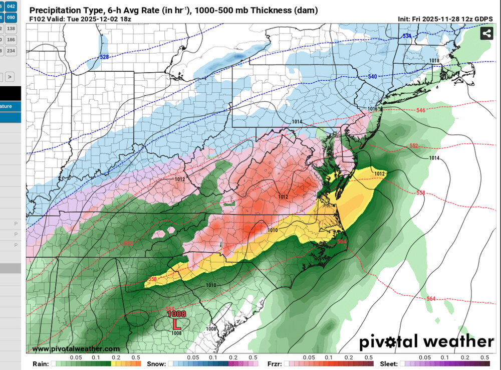
at this point it looks like anyone south of the Pike is mostly wet, anyone north of RT 2 mostly white, probably better WoR folks holding on with ptype issues, but we'll see as we get into the weekend runs, Euro ens have a nice cluster, and then there's next Saturday possible refreshing some... still below 32 here with a stiff NW breeze, expect possible streamers today if I can catch one right.
-
It whitened the ground here an hour or so back.
-
2”+ QPF up to here feels like beer
-

December 2025 regional war/obs/disco thread
HoarfrostHubb replied to Torch Tiger's topic in New England
My daughter will be able to go sledding at her school in S VT though. Looks solid enough there -
CMC like here’s something different
-
December 2025 regional war/obs/disco thread
HoarfrostHubb replied to Torch Tiger's topic in New England
That warm tongue is bigger than Gene Simmons' -
 It's early but starting to like the looks of this for those of us 35 miles or more north of the city, especially with some elevation 500 feet and up.
 -
GFS is a lot more stacked than other guidance (i.e not as sloped with the pressure fields)....it's really going crazy with the main vort focusing and capturing the system....so we're seeing these tucked solutions with crazy QPF and rates....but also warmer for most of our area. I'm actually not sure which one to buy right now....I could be convinced either way. Part of me thinks GFS is a little overdone on this given the synoptics, but it's not impossible to see that solution.
-
Euro will be mocked over this all winter. We're getting revenge for the Ryder Cup.
-

Nov 28-30th Post Turkey Day Wintry Potential
SchaumburgStormer replied to Chicago Storm's topic in Lakes/Ohio Valley
We are so due for an overperformer. Going 11.7” imby -
EPS signals that we still have lots of chances after Dec 2.
-
Feels like bizzaro world with the GFS having a consistent amped up low while the Euro is the SE outlier. After decades of the opposite I don’t know how to feel about this.


