All Activity
- Past hour
-

Central PA Spring 2026 Discussion/Obs Thread
pawatch replied to Voyager's topic in Upstate New York/Pennsylvania
Picked up .67” off the storms. 45 degrees this morning and windy. Not really sure I’m in agreement with the drought map. -
Nice to Stein. Do not need or want any more rain for a month
-

It's time to grade Winter 2025-26(now that it's actually over)
Terpeast replied to CAPE's topic in Mid Atlantic
Solid B. It was a frustrating tracking season for the most part, but the last two snows in March really lifted us. The snowcrete storm and month long snowcover was what made the winter, and we stat-padded our way to median climo. Also, mby got at least 2” for each of the 4 winter months. -

2026-2027 El Nino
snowman19 replied to Stormchaserchuck1's topic in Weather Forecasting and Discussion
The Atlantic is very interesting now too….have we finally, at long last flipped to a -AMO cycle? The last time we were in a -AMO cycle was the tail end of the 1970’s through 1995….. @Stormchaserchuck1 -

-
Yup, .11" last 24 hrs here, temp now down to 42/chill@38 breezy.... shop heat back on
-
Very little rain here, just enough to wet the ground
-
Well, he lives near you, doesn’t he?
-
Rain had some crazy high rates, but thankfully nothing crazy as far as wind here during the storm. It was a nice warm, windy afternoon yesterday.
-

E PA/NJ/DE Spring 2026 Obs/Discussion
The Iceman replied to PhiEaglesfan712's topic in Philadelphia Region
If we ever merged with NY I’d delete my account the next day. Way too many weenies and blowhards up there. Imagine dealing with multiple mickeytims every year? No thanks. Some, I assume, are good people. -

Central PA Spring 2026 Discussion/Obs Thread
mahantango#1 replied to Voyager's topic in Upstate New York/Pennsylvania
0.50 in Day 0.69 in Event 1.55 in Week 6.48 in Month 8.33 in Year Well I'm over the 6 inch mark for rainfall for March,. -

2026-2027 El Nino
bluewave replied to Stormchaserchuck1's topic in Weather Forecasting and Discussion
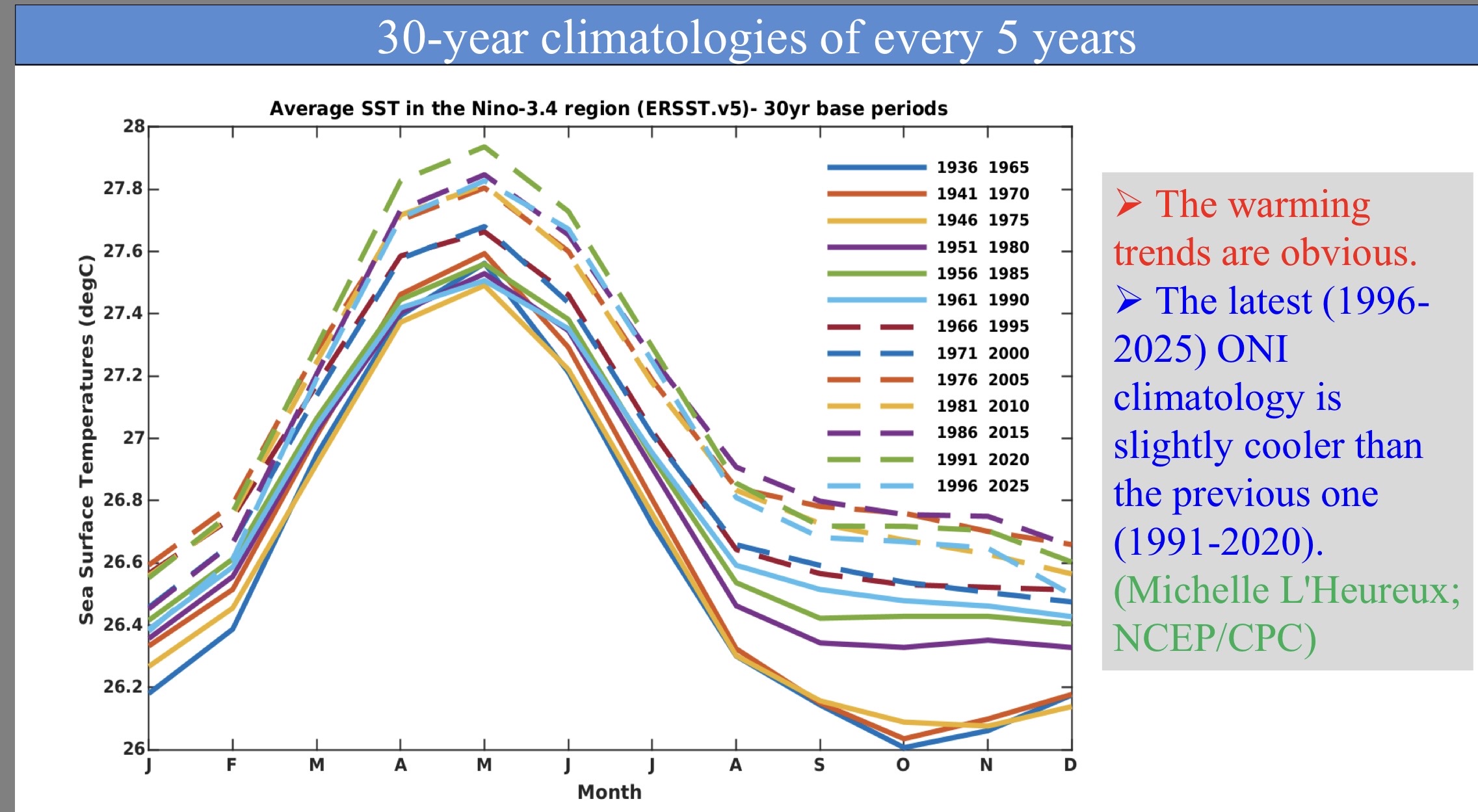
23-24 was similar in strength for total Nino 1+2 to Nino 4 SST warmth and would have registered a peak ONI around +2.4 C had they not changed the baseline making the departure artificially smaller. This is one of the challenges of measuring the El Niño in a warming world. The winter temperatures in North America and 500 ridge was of super El Niño intensity. But the stronger subtropical ridging didn’t allow for the typical Aleutian Trough strength and the Nino trough we typically see in the Southern and Eastern U.S. This could be a function of the continuing mid-latitude marine heatwaves overlapping wit the ENSO influence like we have frequently seen over the last decade. This effectively means that a super El Niño using the weaker RONI started somewhere near +1.4C with the SST configuration we had in 23-24.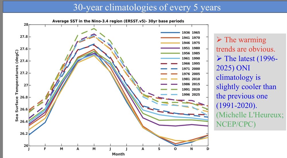
-
Starting to rain, because God forbid I should ever get to walk to the metro station on a morning that's mild enough to not need a jacket without being rained on!
-
What the hell happened to the rain? Less than a 10th of an inch.
-
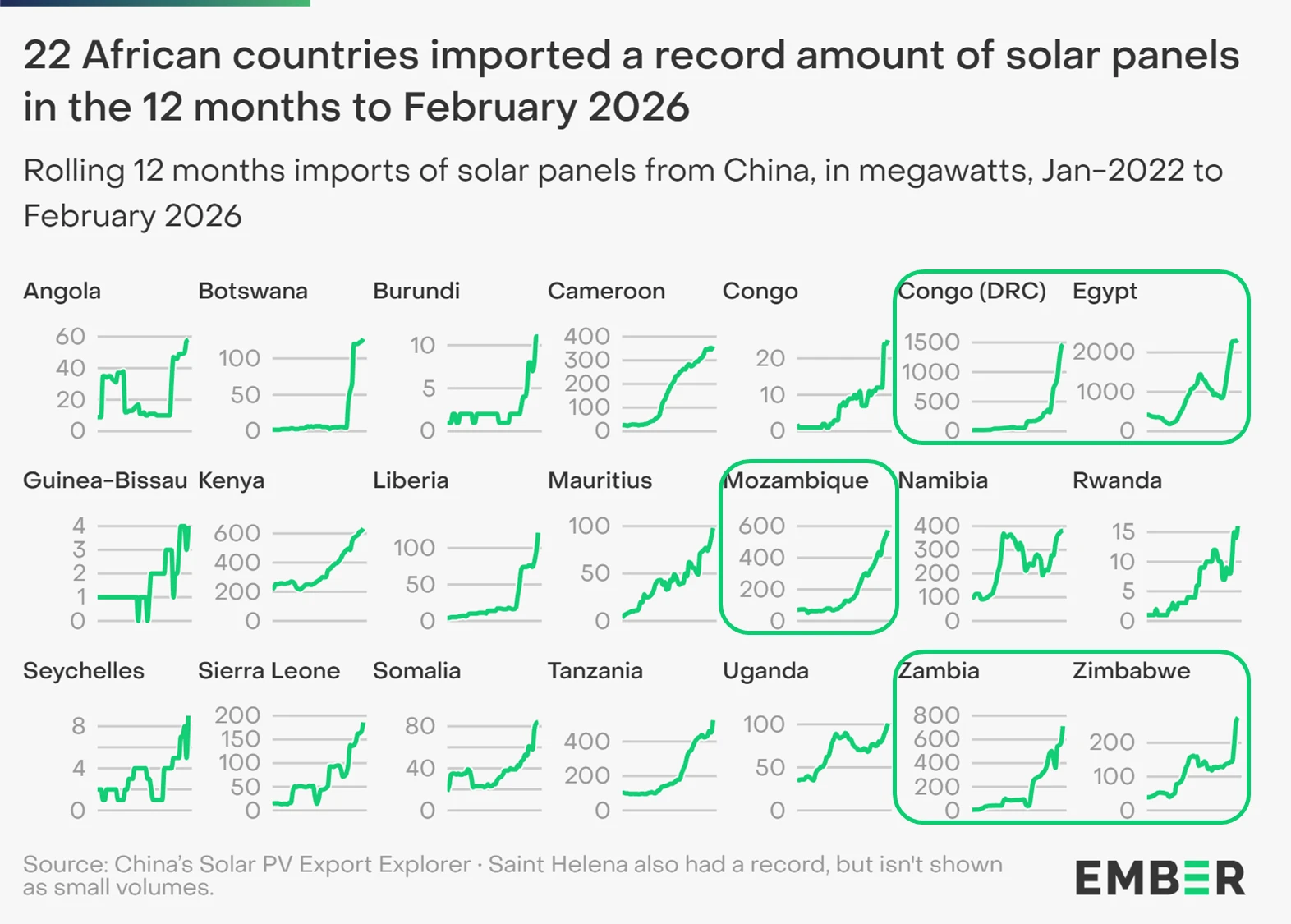
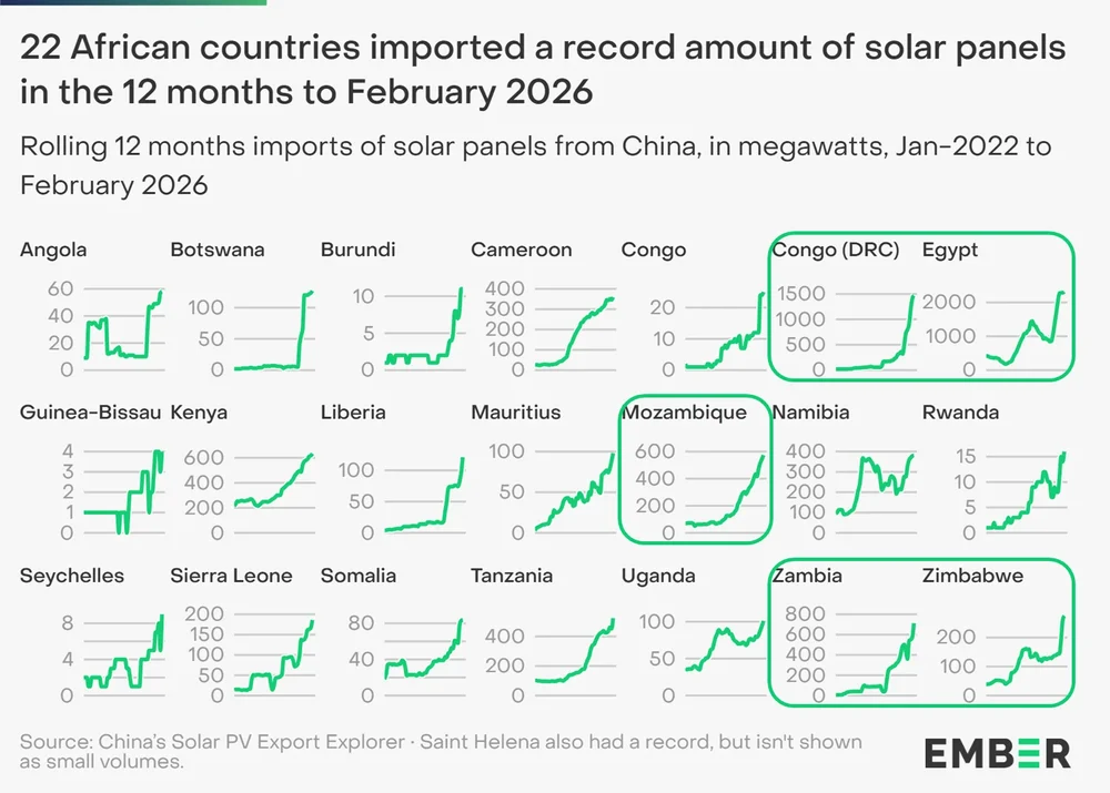
Solar uptake continued to accelerate in Africa in the last month before the energy crisis.
-
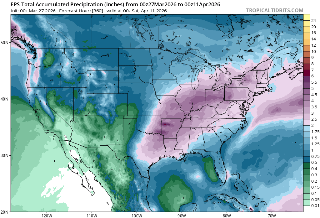
Impressive back door gradient between the CT Shoreline and NJ. My average high has been 47.2° vs 55.3° at Newark. So I haven’t been getting the record warmth that the rest of the CONUS has. Climatological Data for NEW HAVEN TWEED AP, CT - March 2026 Click column heading to sort ascending, click again to sort descending. Sum 1226 808 - - 668 0 4.79 Average 47.2 31.1 39.1 1.3 - - - Normal 46.2 29.4 37.8 - 707 0 2026-03-01 41 26 33.5 -1.2 31 0 T 2026-03-02 27 15 21.0 -13.9 44 0 0.00 2026-03-03 34 15 24.5 -10.6 40 0 0.41 2026-03-04 48 28 38.0 2.6 27 0 0.10 2026-03-05 40 28 34.0 -1.6 31 0 0.75 2026-03-06 39 35 37.0 1.2 28 0 0.31 2026-03-07 41 34 37.5 1.4 27 0 0.09 2026-03-08 55 35 45.0 8.7 20 0 T 2026-03-09 64 30 47.0 10.4 18 0 0.00 2026-03-10 63 31 47.0 10.2 18 0 0.00 2026-03-11 60 41 50.5 13.4 14 0 0.30 2026-03-12 53 32 42.5 5.2 22 0 0.22 2026-03-13 39 31 35.0 -2.6 30 0 0.00 2026-03-14 47 30 38.5 0.7 26 0 0.00 2026-03-15 42 29 35.5 -2.6 29 0 0.00 2026-03-16 55 40 47.5 9.1 17 0 1.68 2026-03-17 53 31 42.0 3.3 23 0 0.01 2026-03-18 35 26 30.5 -8.4 34 0 0.00 2026-03-19 38 28 33.0 -6.2 32 0 0.00 2026-03-20 49 27 38.0 -1.5 27 0 0.08 2026-03-21 53 41 47.0 7.2 18 0 0.00 2026-03-22 48 40 44.0 3.9 21 0 0.17 2026-03-23 49 35 42.0 1.6 23 0 0.67 2026-03-24 46 31 38.5 -2.2 26 0 0.00 2026-03-25 48 28 38.0 -3.0 27 0 0.00 2026-03-26 59 41 50.0 8.6 15 0 0.00 2026-03-27 M M M M M M M 2026-03-28 M M M M M M M 2026-03-29 M M M M M M M 2026-03-30 M M M M M M M 2026-03-31 M M M M M M M Climatological Data for NEWARK LIBERTY INTL AP, NJ - March 2026 Click column heading to sort ascending, click again to sort descending. Sum 1437 963 - - 486 3 3.71 T - Average 55.3 37.0 46.2 4.4 - - - - 0.1 Normal 50.0 33.5 41.8 - 605 0 3.48 5.1 2026-03-01 44 29 36.5 -1.8 28 0 T T 1 2026-03-02 34 21 27.5 -11.0 37 0 0.00 0.0 1 2026-03-03 38 30 34.0 -4.8 31 0 0.42 T T 2026-03-04 47 37 42.0 2.9 23 0 T 0.0 0 2026-03-05 44 39 41.5 2.2 23 0 1.62 0.0 0 2026-03-06 43 37 40.0 0.4 25 0 0.16 0.0 0 2026-03-07 50 37 43.5 3.7 21 0 T 0.0 0 2026-03-08 73 48 60.5 20.4 4 0 T 0.0 0 2026-03-09 73 44 58.5 18.1 6 0 0.00 0.0 0 2026-03-10 82 46 64.0 23.3 1 0 0.00 0.0 0 2026-03-11 82 53 67.5 26.6 0 3 0.35 0.0 0 2026-03-12 64 35 49.5 8.3 15 0 0.07 T 0 2026-03-13 45 30 37.5 -4.0 27 0 0.00 0.0 0 2026-03-14 53 34 43.5 1.7 21 0 0.00 0.0 0 2026-03-15 46 36 41.0 -1.1 24 0 T 0.0 0 2026-03-16 67 45 56.0 13.6 9 0 0.60 0.0 0 2026-03-17 47 31 39.0 -3.7 26 0 T 0.0 0 2026-03-18 37 25 31.0 -12.0 34 0 0.00 0.0 0 2026-03-19 44 32 38.0 -5.3 27 0 0.00 0.0 0 2026-03-20 66 35 50.5 6.9 14 0 0.07 0.0 0 2026-03-21 60 48 54.0 10.1 11 0 0.00 0.0 0 2026-03-22 64 44 54.0 9.7 11 0 0.08 0.0 0 2026-03-23 52 35 43.5 -1.1 21 0 0.33 0.0 0 2026-03-24 50 32 41.0 -3.9 24 0 0.00 0.0 0 2026-03-25 55 34 44.5 -0.8 20 0 0.00 0.0 0 2026-03-26 77 46 61.5 15.9 3 0 0.01 0.0 0 2026-03-27 M M M M M M M M M 2026-03-28 M M M M M M M M M 2026-03-29 M M M M M M M M M 2026-03-30 M M M M M M M M M 2026-03-31 M M M M M M M M M
- Today
-
This wasn't a sudden end though. This winter was basically from early Decemver to end of February. Non stop cold and storms to track.
-
This is an interesting take.

-
-
2026-2027 El Nino
bluewave replied to Stormchaserchuck1's topic in Weather Forecasting and Discussion
This basin-wide warming across the North Pacific overwhelming the PDO is something new. https://www.nature.com/articles/s41558-025-02482-z Pan-basin warming now overshadows robust Pacific Decadal Oscillation The Pacific Decadal Oscillation (PDO) has served as a key index linking basin-scale climate variability to marine ecosystem changes in the North Pacific. However, recent apparent breakdowns of PDO–ecosystem correlations have raised concerns about the stability of the mode and its continued relevance in a warming climate. Here we show that basin-wide warming now overwhelms PDO-related sea surface temperature (SST) variability, although neither the PDO’s spatial pattern nor its strength have changed. We introduce the pan-basin pattern as a complementary index to describe the non-stationary SST baseline of the North Pacific. Regional SSTs increasingly reflect the superposition of these two signals, providing an explanation for weakened or inverted PDO–ecosystem correlations. Future use of the PDO index in management will require discerning the effects of internal dynamics from those of absolute changes in SST as extreme and no-analogue ocean conditions driven by interacting natural variability and anthropogenic warming become more common. -
I can't say I'm surprised. I predicted warm March and April at the beginning of February. I just knew that the cold was going to end at some point. We had 3 solid BN temperature months. The last time it happened was January-March 2015. April 2015 turned warmer, and May 2015 was near record warm. Also, sometimes the cold and snowy winters just come to a sudden end. Just look at 2009-10. After February, things just got warmer in March and temps reached 90 in the first week of April.
-
2026-2027 El Nino
snowman19 replied to Stormchaserchuck1's topic in Weather Forecasting and Discussion
-
Central PA Spring 2026 Discussion/Obs Thread
mahantango#1 replied to Voyager's topic in Upstate New York/Pennsylvania
Andrea Michaels FOX43 PA’s latest Drought Monitor Update was released earlier this morning, with some notable improvements for portions of the Commonwealth! Northeast PA saw the most improvement—going from D0 (Abnormally Dry) conditions to nothing! This includes much of the Endless Mountains, the northern Poconos, and part of the Wyoming Valley. Some of the Middle Susquehanna River area saw improvements from D1 (Moderate Drought) to D0. This includes portions of Centre, Clinton, Snyder, Northumberland, and Union counties. Not much change unfortunately for South Central PA, but we’ve got some decent rain coming tonight! And there will be more opportunities next week too for needed rain. As long as this keeps up, we’ll get there. Patience is key. Climate conditions like this take time to fix if you’re not getting a single, big rain event. -
60 here
-
Saw this post the other day: "Numerical weather models are projecting huge westerly wind burst signal over the west Central Pacific over the next few weeks, some AI models are projecting signals that would achieve near record intensity. The westerly wind burst projected is as zonally and meridionally broad as any historical event I recall, and becomes better centered on the equator than the comparable event of March 1997. Oh boy, March 1997 comparable? 1997-98 was a super El Nino! And 2015-16 was a super one as well. So was 1982-83. So for next winter here? Right away, CoastalWx will go, "IT WILL BLOW b/c it is too warm! Any snow that falls will not stick around!" LOL. Well, it is not all lost, all three of those super El Nino years, we go something good in SNE. Feb 1983 and 2016 E Coast biggies and the "surprise" event 12/23/97 (SNOINCR 8 at Ayer MA). Also, the nasty ZR event NNE and sern Quebec Jan 1998. And the only decent cold shots in such winters are in the NEUS, while the rest of the country is a furnace!