All Activity
- Past hour
-
I have a feeling they will upgrade to warnings for the upper MD eastern shore, N DE, and a chunk of NJ with the afternoon package.
-
-

Pittsburgh/Western PA WINTER ‘25/‘26
Burghblizz replied to Burghblizz's topic in Upstate New York/Pennsylvania
HRRR looks to be trying to bump some of those imbedded bands a little north. -
I know it. At least we’ll have the potential there. Certainly not a torchy look.
-
I mean besides the gfs most models show higher amounts than what nws has. Probably should have advisories back to like Frederick county now.
-
-
I’m surprised Mt Holly hasn’t upgraded to warnings. They have 4-6” for a lot of their area.
-

December 14th - Snow showers or Plowable snow?
TauntonBlizzard2013 replied to Sey-Mour Snow's topic in New England
I didn’t want to say anything but that could be easily 6” if thst verified with decent ratios -
Euro putting me on notice
-

December 2025 regional war/obs/disco thread
Snowcrazed71 replied to Torch Tiger's topic in New England
He wants that ice storm in the worst way. -
When you loop the ensembles, the ridge axis never makes it here. That could be ripe for a good overrunning or SWFE
-

Saturday night/Sunday 12/13-12/14 Jawn
penndotguy replied to Ralph Wiggum's topic in Philadelphia Region
Mt Holly upped our totals out here to 2-4” with WWA Posted now. I would expect DP’s to rise somewhat today with temps mid and upper 30’s and the Se winds. -

Minor snowfall sunday 12/14/25 1-4” possible
MJO812 replied to WeatherGeek2025's topic in New York City Metro
6z eps bumped up snow amounts from 0z
-
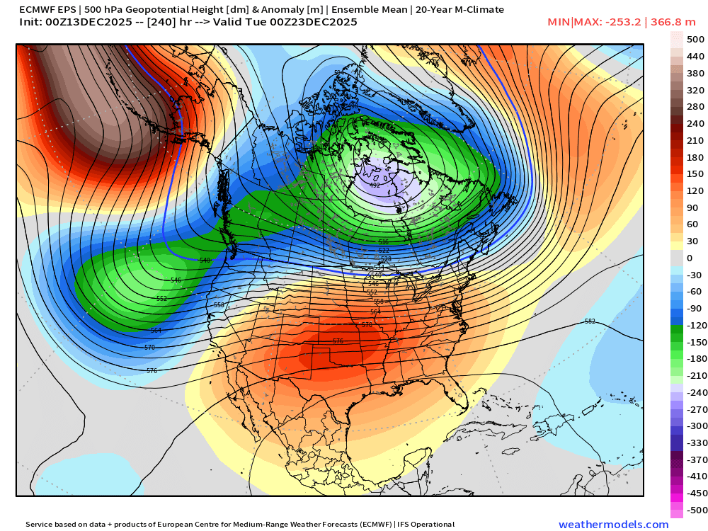
AIFS is similiar. Looks like the pattern changes back to cold and possibly storm during Christmas week.
-
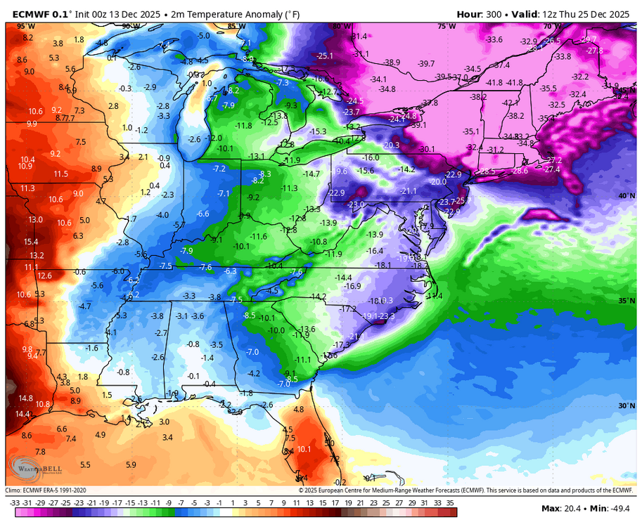
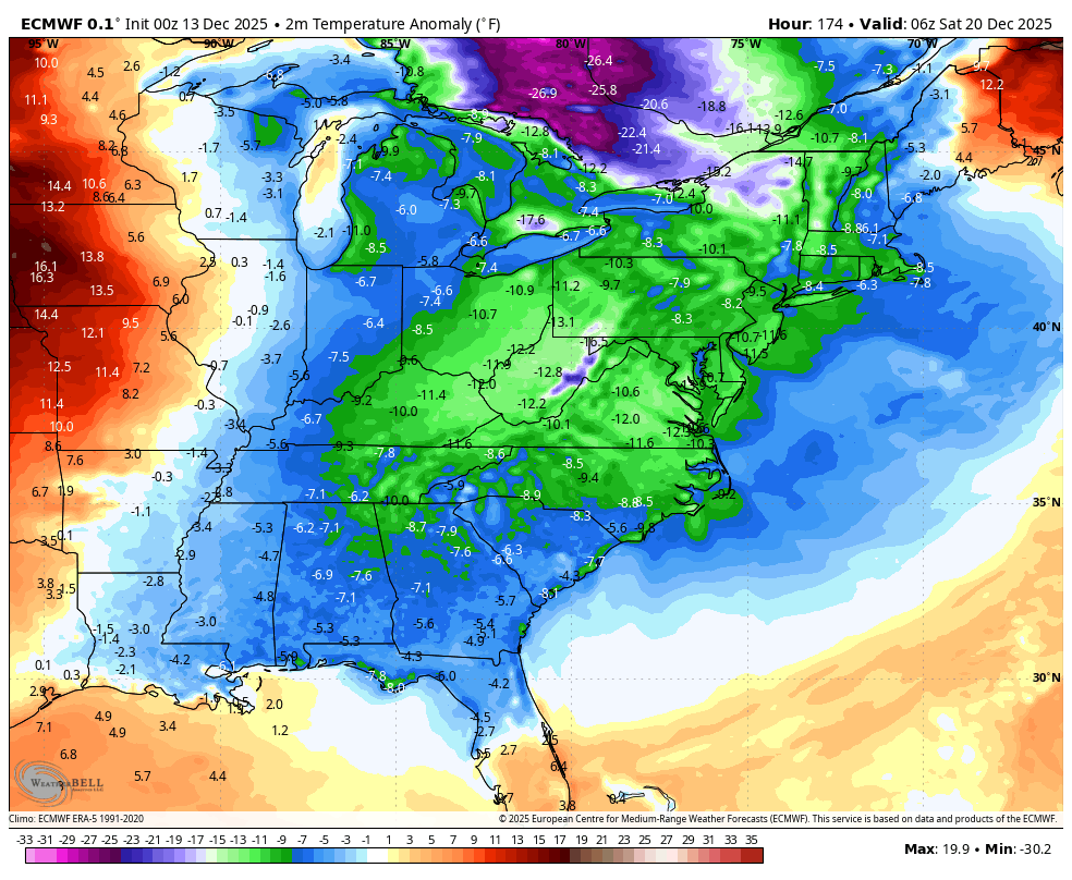
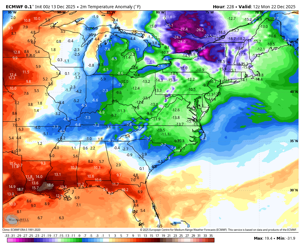
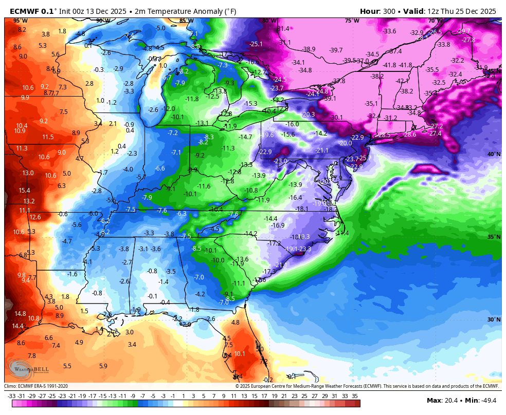
The dreaded 0Z Euro E US torch: awful! 12/20: 12/22: 12/25:


-

December 14th - Snow showers or Plowable snow?
ORH_wxman replied to Sey-Mour Snow's topic in New England
Surprised to see the good trends overnight after the early flaccidness of the 00z runs. I think some of these runs are extremely close to giving the south coast a borderline warning event. Hopefully we can grab a couple inches up to BOS-ORH…still a bit skeptical for the pike region but it’s plausible at least now. -

December 14th - Snow showers or Plowable snow?
HoarfrostHubb replied to Sey-Mour Snow's topic in New England
I’m pulling for the southern folks. -
It’s unfortunate we melt it all later this week but I still think the 21-24 or so offer a chance or two.
-

Saturday night/Sunday 12/13-12/14 Jawn
Newman replied to Ralph Wiggum's topic in Philadelphia Region
1am sounding for Allentown off the 3k, wow! Plenty of ascent right in the DGZ. The 10pm - 3am timeframe will probably be when the LHV gets the best rates before everything shunts southeast. Snow might be done by sunrise tomorrow morning.thumb.png.15039e680f80f47d90cace2746488a16.png)
-

December 14th - Snow showers or Plowable snow?
CoastalWx replied to Sey-Mour Snow's topic in New England
Wow decent trends overnight. Would be great to get 1-2 here. -
Stop trying
-
I hope we all do but I really hope those who have bare ground get some. Tis the season.
-
"Two houses up" can be quite different here than in your area. For instance, for me "two" houses up in one direction is half a mile, in the other direction it is 4 miles.
-

December 2025 regional war/obs/disco thread
Damage In Tolland replied to Torch Tiger's topic in New England
Some warmth aloft -

December 2025 Short/Medium Range Forecast Thread
Carvers Gap replied to John1122's topic in Tennessee Valley
I don't have a lot of time this morning. A trend worth watching...overnight and morning deterministic runs (CMC, Canadian para, 6z AIFS, and 0z Euro) continue to erode the warmup. That doesn't mean we won't see warm air masses, but go look for yourself. They have, even the gfs, found the Dec 20th cold front. This really looks like more of a back-and-forth pattern where warmth surges, cold erodes it quickly due to the cold source, and wash/rinse/repeat. Ensembles aren't there yet, but at this range...they will wash out any trends.


.png.f07c2ebea5f340a7ca20012952e6e770.png)

