All Activity
- Past hour
-
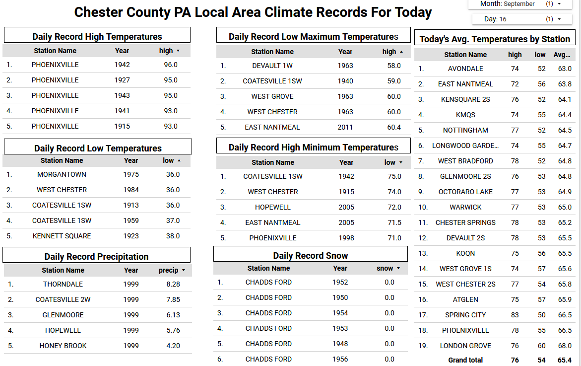
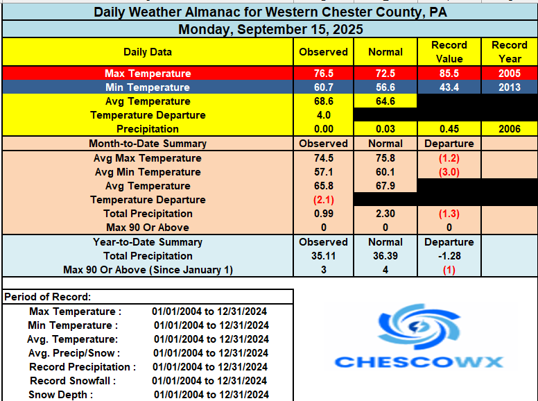
It’s a good bit cooler today with the flow off the ocean increasing and mostly cloudy skies. Despite the current NWS forecast for mid-70's I suspect across the higher spots we may struggle to escape the 60's to near 70 degrees for high temperatures today. Some showers arrive this evening and through the day tomorrow. Certainly not a lot of rain but any and all will be appreciated by our many area farmers. We briefly warm by Friday to the low 80's before we cool down for the weekend.
-
(002).thumb.png.6e3d9d46bca5fe41aab7a74871dd8af8.png)
E PA/NJ/DE Autumn 2025 Obs/Discussion
ChescoWx replied to PhiEaglesfan712's topic in Philadelphia Region
It’s a good bit cooler today with the flow off the ocean increasing and mostly cloudy skies. Despite the current NWS forecast for mid-70's I suspect across the higher spots we may struggle to escape the 60's to near 70 degrees for high temperatures today. Some showers arrive this evening and through the day tomorrow. Certainly not a lot of rain but any and all will be appreciated by our many area farmers. We briefly warm by Friday to the low 80's before we cool down for the weekend.
-
Yeah we are not getting any rain from this system at this point. NWS will have to catch up.
-
I don't think it's means much in the sense that it will nail the forecast per se, as the CFS is really only useful anout a month out; however, it is very notable because the model is usually warm in the winter.
-
-
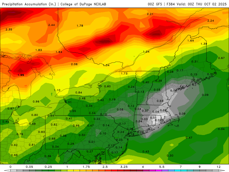
Bust on the rainfall here that is for sure.
-
I cannot believe how dry it’s gotten after back to back 9”+ rainfall months at my house. We’re on track to finish with under 1/2” of rain for the entire month and I frankly don’t see another rain chance unless something tropical happens
-
Yeah that isn't happening at all.
-
Fires !
-

September 2025 OBS-Discussion centered NYC subforum
bluewave replied to wdrag's topic in New York City Metro
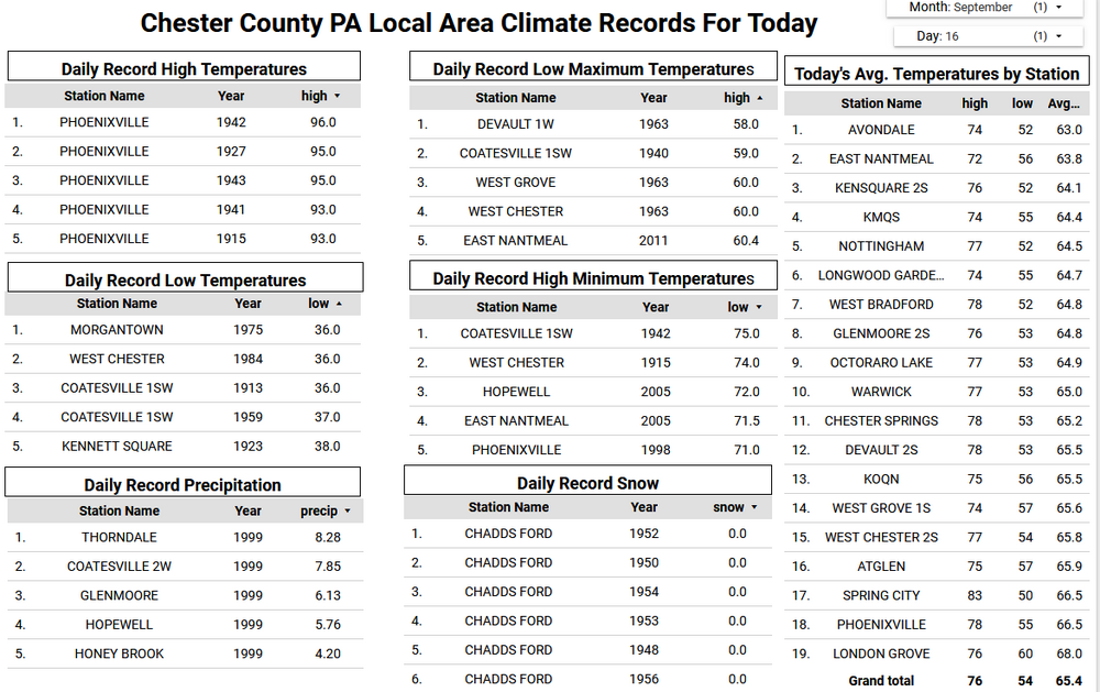
The cold departures will be shrinking over the next few weeks. Looks warmer than average especially over the driest areas to our west. Whether the warm spots across the area see more mid 80s like the past several days will come down to wind direction. Data for September 11, 2025 through September 15, 2025 Click column heading to sort ascending, click again to sort descending. TETERBORO AIRPORT WBAN 90 TETERBORO AIRPORT COOP 90 SOMERSET AIRPORT WBAN 86 CALDWELL ESSEX COUNTY AP WBAN 85 HARRISON COOP 85 SUSSEX AIRPORT WBAN 84 TRENTON-MERCER AIRPORT WBAN 84 NEW BRUNSWICK 3 SE COOP 84 PENNSAUKEN 1N COOP 84 Trenton Area ThreadEx 84 New Brunswick Area ThreadEx 84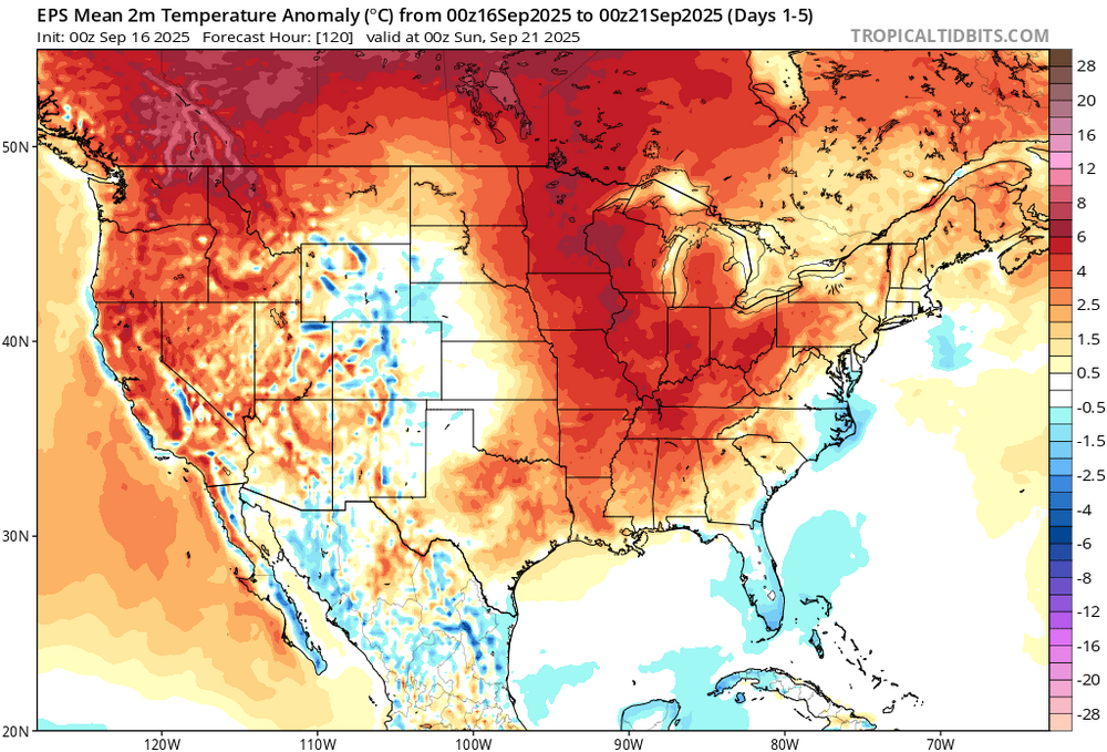
-

O'Brother Septorcher
Prismshine Productions replied to Prismshine Productions's topic in New England
Are you freaking kidding me. Imagine it is the opposite in winter and the jackpot zone is Hippy, me, Astro, and up to you while ineedweenies is malding about having mix issues Sent from my SM-S166V using Tapatalk - Today
-
Arctic Sea Ice Extent, Area, and Volume
Prismshine Productions replied to ORH_wxman's topic in Climate Change
There a product link to that data? Sent from my SM-S166V using Tapatalk -
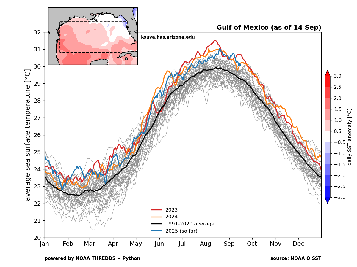
The Atlantic SSTs are still near the warmest on record. So this lull is more about the warmer waters further north across the oceans causing too much tropical stability. The Gulf SSTs are near the warmest on record also. So any system can get into the Gulf would have plenty of fuel. I am hoping that that area can catch a break from all the damage that has occurred the last decade. But the local residents can’t let their guard down. Since much of the activity has been backloaded into the late season there.

-
Well so much for any rain in central NC
-

September 2025 OBS-Discussion centered NYC subforum
SnoSki14 replied to wdrag's topic in New York City Metro
How warm the rest of the month will be probably depends on how close that tropical system gets once again. Models aren't handling that very well right now. -
September 2025 OBS-Discussion centered NYC subforum
bluewave replied to wdrag's topic in New York City Metro
Happy Birthday. The models have an earlier frontal passage now on Friday. So the warmest 850s come through Thursday night. More like low 80s around Friday as the 850s are much lower now during the day than the older model runs. -
Sorry to hear that! My MIL had a slight leak on the hot water stop valve under her sink. Must have been leaking for weeks. Damaged the cabinet and carpet under the cabinets and had all kinds of nasty stuff that had to be cleaned up this weekend. Wet nasty Particleboard is the worst stuff to pull out......Good luck!
-
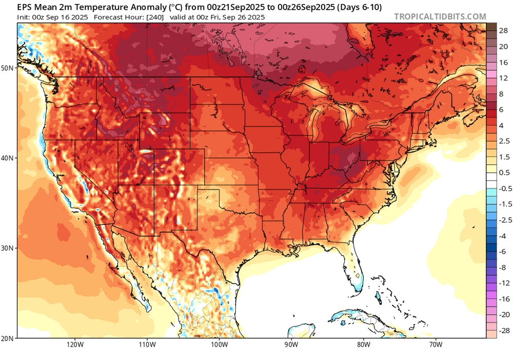
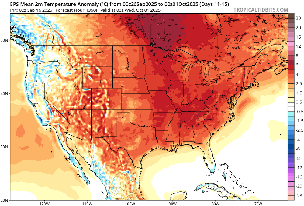
Still looks on target for a late month and October flip (Chuck’s -PDO/-ENSO link for October) to a warmer than normal pattern, also continued very dry. Once we get into October, if the dryness continues and it looks like it will, we will be approaching serious drought conditions
-

2025 Atlantic Hurricane Season
WolfStock1 replied to BarryStantonGBP's topic in Tropical Headquarters
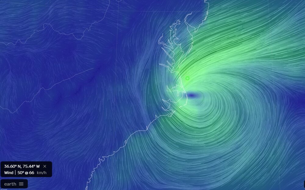
This is showing winds of 66 kph - so it's fast enough.
-
Interesting. Well, I know it's not tropical, but it is now showing winds up to 66 kph:
-
Nam has taken a couple of steps in the right direction the last couple of runs.
-
00z lol Can’t even buy a fantasy light rain event
-

Invest 92L--80% two day, 90% five day odds
GaWx replied to WxWatcher007's topic in Tropical Headquarters
Many are. And at least there’d be something interesting to follow with hopefully nobody needing to worry about potential devastation and casualties. I say hopefully nobody because there’s still some chance Bermuda will be hit. Fortunately though, Bermuda handles storms pretty well due to good elevation just off many of the beaches (hilly terrain) and very strict building codes. This includes limestone roofs! I’ve been there. -
I did not ski 100 days last year either. 5 of the last 7 seasons I did though and I hope to hit it again this year.
-

September 2025 OBS-Discussion centered NYC subforum
rclab replied to wdrag's topic in New York City Metro
May you continue to ring and of course, post. As always……