All Activity
- Past hour
-
-


-
So much for the big warmup. Great to see!
-
Yes, The first ones of the season too is the other period that they will do this especially if it affects the commuting hours.
-

December 2025 regional war/obs/disco thread
Chrisrotary12 replied to Torch Tiger's topic in New England
Cue Coastal complaining about the blob off California. -

White Christmas Miracle? December 23-24th
The 4 Seasons replied to Baroclinic Zone's topic in New England
yea thats what i figured. i've seen a few weird ones like this in the past, and i remember one in November one time that was sub-advisory 1-3" but they put one out because it was the first one of the season, and it was right at rush hour. -

White Christmas Miracle? December 23-24th
weatherwiz replied to Baroclinic Zone's topic in New England
I think it also has to do with the timing plus the increased holiday travel...just a way to increase awareness -
 NWS hiking amounts slightly, I was at 1" or less, now @ 1" - 2"...getting there.
 -

December 2025 Short/Medium Range Forecast Thread
Carvers Gap replied to John1122's topic in Tennessee Valley
Digging through ensemble members. It looks like there is potential for another strong cold front on Jan6-7 - per GEFS. This looks like a very active pattern coming up in regards to cold. Let's hope some precip can work its way in. I would think clippers and NW flow would be on the table for even norther portions of Gulf States IF that pattern verifies. -
We had a bunch of these in 93-94, I feel we've had basically none since minus PDII
-
Sunset times are already increasing went from 4:24 here around dec 10th to 4:28 today
-
Be interested to see ind members cause op not even close to brining snow to Maryland so there’s got to be some big hits in the mix.
-
NWS does this because of holiday travel to make folks aware.
-
December 2025 Short/Medium Range Forecast Thread
Carvers Gap replied to John1122's topic in Tennessee Valley
I know this is a bunch of posts and my apologies. The 12z para GDPS goes back-to-back w/ cold fronts beginning w/ the 28-29th. We could certainly be cold and dry. That is with precedent. However, the storm track should be suppressed with this. With the return flow behind these fronts, one would think at some point either the cold air doesn't get out of the way(over running WAA) or the warm air doesn't get out of the way. To me, the para GDPS is a logical path forward, but by no means not the only one. -

White Christmas Miracle? December 23-24th
40/70 Benchmark replied to Baroclinic Zone's topic in New England
Kinky -
Eps
(26).thumb.png.0d4404168e7b046363779c12d6e50901.png)
-
EPS continues to tick colder. mean is about 4" for NYC i generally like this kind of event... shove moisture into HP and you usually have success


-
Well I'm hoping it keeps coming south!!!!
-

White Christmas Miracle? December 23-24th
WinterWolf replied to Baroclinic Zone's topic in New England
Lol…they’re just covering the bases/their asses. -
 Winter weather advisory for orange and Putnam County and Western Passaic tonight. Calling for 2 to 3 inches. I'd be overjoyed if we hit the high end.
 -
Blowtorch effect
-
December 2025 regional war/obs/disco thread
WinterWolf replied to Torch Tiger's topic in New England
I wouldn’t worry about that at this point…but I know that feeling. Many times when I head up to N. Maine….storms seem to threaten CT/SNE when I’m gone lol. -
If we didn't have bad luck… you know the saying lol. I found it interesting that every other Christmas Day since ~2018 has been 50°+ over here per a local met. If I get some time later I’ll check that out.
-
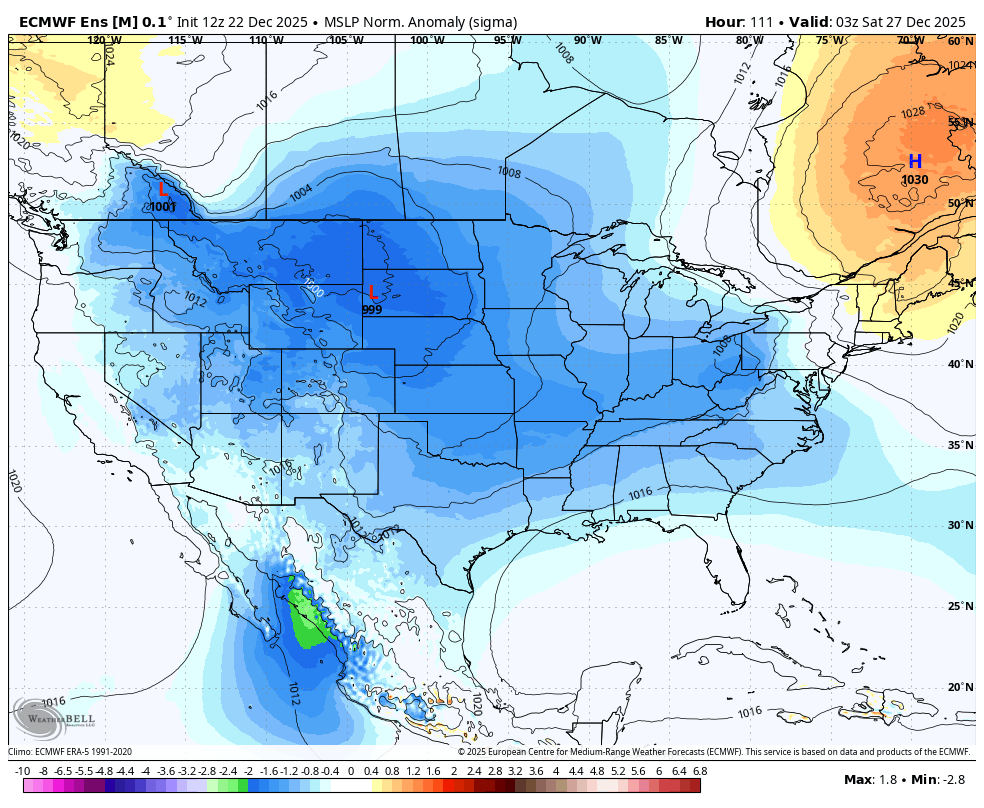
The models keep missing the blocking in the long range. What a massive change.
-

White Christmas Miracle? December 23-24th
NW_of_GYX replied to Baroclinic Zone's topic in New England
Ya the last one that really jacked my area was in February 2017? I think. Great ratios with that one iirc


(26).png.e36291c9032ae49f7b630721fbad15ba.png)