All Activity
- Past hour
-

2026-2027 Strong/Super El Nino
GaWx replied to Stormchaserchuck1's topic in Weather Forecasting and Discussion
Pretty solid -SOIs all due to very low Tahiti SLP as Darwin is also a bit BN: 16 May 2026 1008.21 1009.70 -23.11 -7.40 -0.93 15 May 2026 1009.15 1010.00 -18.21 -6.36 -0.50 14 May 2026 1009.81 1010.30 -15.45 -5.70 -0.07 13 May 2026 1010.40 1010.50 -12.47 -

Central PA Spring 2026 Discussion/Obs Thread
mahantango#1 replied to Voyager's topic in Upstate New York/Pennsylvania
Sounds like Hazelton will give you depression. I was up to Hazelton a few times to attend a class, seminar (for my employer) at The Top of the 80's about 10 years ago. Yes it's a different world up ther. -
Records: Highs: EWR: 92 (1951) NYC: 90 (1951) LGA: 90 (1951) JFK: 83 (1993) Lows: EWR: 40 (2016) NYC: 42 (1878) LGA: 41 (1983) JFK: 43 (1983) Historical: 1858: Richmond, Va. Area - Chesterfield County, VA Terrible Hail Storm Damage - Sunday, May 16, 1858: A terrible hail storm occurred in Chesterfield County last evening. Some of the stones were of the size of hen's eggs. Vegetation was destroyed, the ground strewn with the leaves and branches of trees, and a great many windows broken. The hail was from two to three feet deep in some places in the roads. The train from Petersburg last evening came in contact with a fallen tree, and the engine and cars were much damaged. The storm is unprecedented. The New York Times, New York - May 17,1858 by Stu Beitler 1874 - The Mill Creek disaster occurred west of Northhampton MA. Dam slippage resulted in a flash flood which claimed 143 lives, and caused a million dollars property damage. (David Ludlum) 1883: A three-day flood was in progress throughout the Black Hills of South Dakota which resulted in damages over one million dollars in the Rapid City area. (Ref. Wilson Wx. History) 1898: Heavy hail many windows broken in Baltimore along with 1.38 inches of precipitation. 1899: A tornado causing F4 damage moved east northeast from 3 miles northwest of Greeley in Delaware County, Iowa to northwest of Colesburg into Clayton County, Iowa. At least five farms were hit. The tornado narrowed to only 75 yards near Colesburg and swept away all buildings including homes on three of the farms. Two people were killed in one family and four others may have died later. Four men were caught in the one mile from Colesburg and two of them were killed as they looked for shelter. A tombstone of some kind was reportedly carried for two miles. This tornado killed 4 people, all in Clayton County and injured 14 others. (Ref. Wilson Wx. History) 1911: Record maximum temperature for Washington, DC for the date is 93 °F. (Ref. Washington Weather Records - KDCA) 1924 - The temperature at Blitzen OR soared to 108 degrees to set a state record for the month of May. The record was later tied at Pelton Dam on the 31st of May in 1986. (The Weather Channel) 1943: A late season storm brought 10 inches of snow to Cheyenne, WY. (Ref. Wilson Wx. History) 1946: A severe hailstorm at San Antonio, TX caused $5 million dollars damage and injured 20 people. (Ref. Wilson Wx. History) 1952 - High winds in the Wasatch Canyon of Utah struck Ogden and Brigham City. Winds at Hill Air Force Base gusted to 92 mph. (The Weather Channel) 1968: A tornado skipped for 45 miles from south of Wabash to New Haven, IN. A woman was killed when her mobile home was blown across a highway and demolished. New Haven was hardest hit with 15 homes damaged. Planes were damaged at the Wabash Airport. (Ref. Wilson Wx. History) 1975: Wildwood, Fla.--One man was killed by lightning and one injured in an open field as they were running for shelter. (Ref. Lightning-The Underrated Killer.pdf) 1983: A very strong spring storm dumped heavy snow across the Front Range in Colorado. Strong winds of 20 to 40 mph with gusts to 55 mph produced blizzard conditions at times. The Foothills received 1 to 2 feet of snow with 4 to 12 inches along the Foothills. Blowing snow whipped the snow into drifts several feet deep closing schools and highways. Power outages occurred; with 20 square miles of Denver blacked out. Hundreds of passengers were stranded as only half of runways were open at Stapleton International Airport. The high temperature at Denver the next day of just 40° set a record low maximum. Much of the snow melted on the 18th as temperatures rebounded into the middle and upper 50s causing widespread street flooding. (Ref. Wilson Wx. History) 1987 - It was a summer-like day as thunderstorms abounded across the nation. Thunderstorms in Texas drenched Guadelupe County with more than three inches of rain resulting in flash flooding. (The National Weather Summary) (Storm Data) 1988 - Afternoon and evening thunderstorms developing ahead of a cold front produced severe weather from Florida to New York State. Unseasonably warm weather prevailed in the north central U.S. Havre, MT, reported a record high of 95 degrees. (The National Weather Summary) 1989 - Thunderstorms developing ahead of a cold front produced severe weather in the south central U.S. Thunderstorms spawned twenty tornadoes, and there were 180 reports of large hail and damaging winds. A tornado at Cleburne, TX, caused 30 million dollars damage. A violent (F-4) tornado touched down near Brackettville, TX, and a strong (F-3) tornado killed one person and injured 28 others at Jarrell, TX. Thunderstorms also produced softball size hail at Shamrock, TX. (The National Weather Summary) (Storm Data) 1990 - Thunderstorms produced severe weather from eastern Oklahoma and northeastern Texas to the Upper Ohio Valley. Thunderstorms spawned seventeen tornadoes, including a twister which killed one person and injured another north of Corning, AR. There were 128 reports of large hail or damaging winds. Strong thunderstorm winds killed one person and injured six others at Folsomville, IN, and injured another five persons in southeastern Hardin County KY. In Arkansas, baseball size hail was reported near Fouke and near El Dorado. (The National Weather Summary) (Storm Data) 1991: At least 6 tornadoes struck parts of northeastern Oklahoma. The strongest rated an F2, struck Catoosa, causing an estimated $130,000 dollars in damage, but no injuries. Severe thunderstorms produced hail 5 inches in diameter at Wichita, KS. (Ref. Wilson Wx. History) 1995: On this date through the 17th, 6.55 inches of rain fell at St. Louis, MO. This is the fifth greatest 24-hour total amount of precipitation for that location. 5.73 inches of rain fell at Columbia, MO making it the sixth greatest 24-hour total amount of precipitation for that location. 1997: Sioux City, Iowa: Sioux City sets daily high and low records on same day: 91 °F and 22 °F, respectively. The record is fortuitous as on no earlier spring date was the record low temperature so high, and on only one May date was the record high any lower. (Ref. WxDoctor) 3.2 inches of snow fell at Marquette, MI bringing their seasonal accumulation to 272 inches to establish the all-time record seasonal snow total for Marquette County Airport. It was also the fifth consecutive day with measurable snow, setting the record for consecutive days with measurable snow during the month of May. While mid-May snow is unusual, it's not the latest in the season it has ever snowed at Marquette. The latest measurable snow there is 0.2 inches on 6/2/1910. The latest date with at least 1-inch of snow is 5/29/1947 with 2.1 inches of snow falling. (Ref. Wilson Wx. History) 1999: As a mother and daughter were driving to a more substantial shelter from their mobile home in Logan, IA when a tornado began to overtake their car. They followed the old advice of seeking shelter in a ditch. As they huddled in the ditch, a large piece of farm equipment and a car fell on them, killing the daughter and injuring the mother. Such incidents have caused Meteorologists and safety experts to question the old standard advice of leaving your car to seek shelter in a ditch when a tornado approaches. The most important advice is not to be caught out during a tornado situation. Lightning struck a home at Rochester, MN blowing a hole in the wall of the kitchen as well as blasting the bark off a tree in the backyard. In addition, the lightning also set off an explosion in a nearby sewer, which damaged three homes and caused a gasoline leak. Several neighborhoods were evacuated. Damage was estimated at $25,000 dollars. (Ref. Wilson Wx. History) 2002: Most rivers across central and southeast Illinois were flooding, due to runoff from heavier rain several days earlier. The Embarras River at Lawrenceville, IL crested at record levels on this date, while the Sangamon River crested from the 14th through this date at 2nd to 3rd highest levels on record. The Illinois River would crest later in the month around the third highest level on record. (Ref. Wilson Wx. History) 2006: Lightning caused a fire that ruined a refurbished World War II barracks on the FAU campus in Boca Raton, Florida. The the barracks was made of Dade County pine the 21,000 square feet barracks was dedicated 10 days before the fire and was nominated for the National Registry of Historical Places. (Ref. Weather Guide Calendar with Phenomenal Weather Events 2007 Accord Publishing, USA) 2010: Hail to softball size pounded a northwest to southeast track across the Oklahoma City, Oklahoma, metro area. Many expensive homes in Nichols Hills had total roof damage; many windows shattered in homes and vehicles. Hail fog obscured what appeared to be a snow-covered ground after the storm. (Ref. Weather Guide Calendar with Phenomenal Weather Events 2012 Accord Pub. 2011, USA)
-
Faint aurora over Gitche Gumee last night.

-
62 / 51 and on the way to upper 70s to low/mid 80s today. A touch warmer tomorrow with some mid 80s and some stray 90. About the same Monday before stronger heat low - mid 90s Tue / Wed. Wed front / clouds timing the caveat. Front comes through Wed night into Thu with the next shot at rain / showers / thunderstorms >.50. Cools down Thu - Sat before warming back up as ridge builds over Memoridal day weekend. Overall warmer beyond with next shot at heat 5/26 - 5/30.
- Today
-
About 0.43" of rain here overnight. It was nice to hear thunder and rain on the roof again.
-
Euro and GFS AI models very bullish for a washout holiday weekend. Would rather it be during the week of course, but 2-3” of rain over 2-4 days is sooo needed.
-
Did I win the install competition by never taking them out of the windows last Fall? All four are locked and loaded for the heat next week. Though I may not need it in my coastal location thanks to sea breezes...
-
Volunteering at Hampstead Day today, if you’re in the area come by and say hi! I’ll be at a dance studio table
-
88° at your glacial moraine is a torch
-

Central PA Spring 2026 Discussion/Obs Thread
Voyager replied to Voyager's topic in Upstate New York/Pennsylvania
I got stuck doing Hazleton loads yesterday. That godforsaken place has a whole different climate from even Tamaqua. Save for a brief period of sunshine, it was mostly overcast and windy up there, and I had to wear my hoodie almost all day. I checked the local stations and it didn't get above 60 the whole time I was up there. The Hazleton climate is the main reason why I hate delivering to that customer. -
Boring ass weather sucks. It's almost June and I've only heard one rumble of distant thunder so far this spring. Soooooo Boring
-
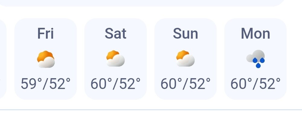
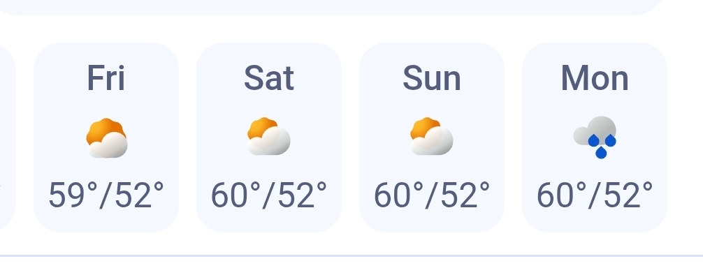
Might not even install pretty meh overall Sunday Sunny, with a high near 80. West wind 6 to 13 mph, with gusts as high as 25 mph. Sunday Night Mostly clear, with a low around 49. West wind around 5 mph becoming calm in the evening. Monday Sunny, with a high near 80. Calm wind becoming south 5 to 9 mph in the afternoon. Monday Night Mostly clear, with a low around 58. Southwest wind around 7 mph. Tuesday A chance of showers after 5pm. Sunny, with a high near 88. West wind 5 to 13 mph. Chance of precipitation is 30%. Tuesday Night Partly cloudy, with a low around 64. Southwest wind around 6 mph. Wednesday A chance of showers after 1pm. Partly sunny, with a high near 86. West wind 7 to 13 mph, with gusts as high as 24 mph. Chance of precipitation is 40%. Wednesday Night A chance of showers before 11pm. Mostly cloudy, with a low around 51. West wind around 8 mph. Chance of precipitation is 40%. Thursday Mostly sunny, with a high near 67. Northwest wind 7 to 9 mph. Thursday Night Partly cloudy, with a low around 44. North wind 3 to 5 mph. Friday Mostly sunny, with a high near 65. North wind 3 to 6 mph.
-
A few days then back to better weather
-
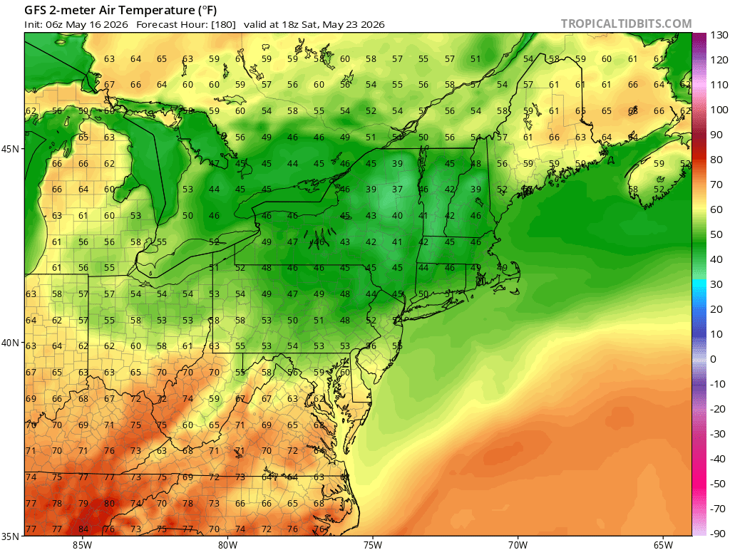
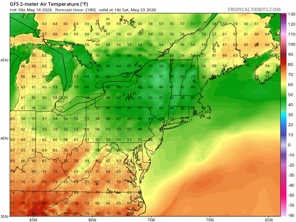
Most models have it at some point next weekend..
-
ACATT really really struggling as we now enter HHH season. Time to accept and enjoy and get after it
-
Keep looking deep into the modeling rectum for the coldest maps you can find.
-
Enjoy the heat all of you ACATTers
-

Central PA Spring 2026 Discussion/Obs Thread
pawatch replied to Voyager's topic in Upstate New York/Pennsylvania
42 degrees again this morning. Probably grass mow # 9 today. -
51 for the low. Beautiful morning.
-
Next weekend starts off nice on the GFS though
-
Rain... 40s low 50s for highs. GFS is better though but its close
-
Central PA Spring 2026 Discussion/Obs Thread
mahantango#1 replied to Voyager's topic in Upstate New York/Pennsylvania
Yesterday the afternoon was really nice to be out. My high was 73 -
Rain? Sent from my SM-S921U using Tapatalk
-
It does. Monday looks a little iffy.