All Activity
- Past hour
-
Sounds like half bears fans in the crowd down in atl
-
29 degrees here.
-
Yes, I do not like that term either. "Thunderstorm" is best b/c it means w/ or w/o precip which covers it all b/c how many time do you not get a drop of rain but you get LTG/T that sends @weatherwiz and @ineedsnow bouncing off the walls!? Or @CoastalWxgetting a jolt from his PC b/c of an isolated +CG hits very close that scares the bejesus out of him, but it is sunny out? And when you get to desert regions, many tstms never get a drop to the ground since it is all virga, yet the LTG/T is nasty! And when you say "thunder," that by default means convective, even when it is from CSI or embedded in a large area of synoptic precip (convective elements), so the precip is showery in nature and thus "showers" attached to thunder is redundant. I bet @CoastalWx still uses "thunderhead" to describe a CB! Also, "heat lightning!" Or he may go, "why is is called a "funnel cloud" when it always does not look like a funnel!"
-

E PA/NJ/DE Autumn 2026 Obs/Discussion
RedSky replied to PhiEaglesfan712's topic in Philadelphia Region
low was 32F light freeze -
The many upcoming chilly nights throughout the SE that have started will accelerate the autumn leaf changes everywhere. Is anyone seeing significant colors yet? I expect higher elevations almost certainly are, but what about those at 1,000 feet or lower? Here, the deciduous trees are almost all still green. By the end of the week, however, I wouldn’t be surprised to see a few starting to change even this far SE at near sea level.
-

October 2026 OBS
WinstonSalemArlington replied to WinstonSalemArlington's topic in Southeastern States
The end of the growing season -
October 2026 OBS
WinstonSalemArlington replied to WinstonSalemArlington's topic in Southeastern States
Frost and Freeze -

2026-2027 Record-breaking El Nino
mitchnick replied to Stormchaserchuck1's topic in Weather Forecasting and Discussion
It's wrong if it's not your forecsst. Isn't that the way it always works? Lol -
I think you’ve just about summed it up right there… saving me half of the effort. All the super nino analogs are only partial matches, and we’ve never had it this east based. If I had to guess what would happen in the atmosphere this winter, the N Pac low would be right up against the western canada coast, and the southern trough would be pulled west, making it one longwave trough rather than two separate troughs. Not saying we’ll get a SE ridge, we’ll still have a screaming STJ but embedded within a zonal flow east of the rockies, which would also bring us milder temps on the mean. Still an elevated chance for a big one compared to all winters, but not compared to other favorable ninos. If I were a betting man, I’d pass on the big one this year. As far as temps go, thinking 4-6 AN DJF, and BN snow. Way above AN precip though mostly rain. Maybe a surprise march snow.
-

2026-2027 Record-breaking El Nino
snowman19 replied to Stormchaserchuck1's topic in Weather Forecasting and Discussion
That is if it even ends up being a -PDO winter. I have serious doubts about that one. I think it at least flips to weak positive -

2026-2027 Record-breaking El Nino
40/70 Benchmark replied to Stormchaserchuck1's topic in Weather Forecasting and Discussion
I don't think it's the -PDO in and of itself that is significant, but it's how we are getting there...this isn't our grandparent's EOF. -
2026-2027 Record-breaking El Nino
40/70 Benchmark replied to Stormchaserchuck1's topic in Weather Forecasting and Discussion
Not at all what I said. Who declared victory in October? 1.2 is such a tiny area it isn't even possible to he convectively dominant. The most prolific convection is actually south of Hawaii...which is independent of what I think will go on in the higher latitudes. -
Good point on snowfall measurements. I wonder if it may change for temps as I see now at least at KMGJ that when you look at the three days history they do now show temp readings to the tenth.
-
2026-2027 Record-breaking El Nino
40/70 Benchmark replied to Stormchaserchuck1's topic in Weather Forecasting and Discussion
No, you're fine...nothing wrong with a healthy debate..no one is out of line. All I'm saying is I am growing quite confident that that current in conjunction with other factors is going to foster a pattern in the higher latitudes that is absolutely independent of the strongest El Nino in history...not 'trump' it. Obviously much more in depth in a few weeks for those who have the time to delve in. -
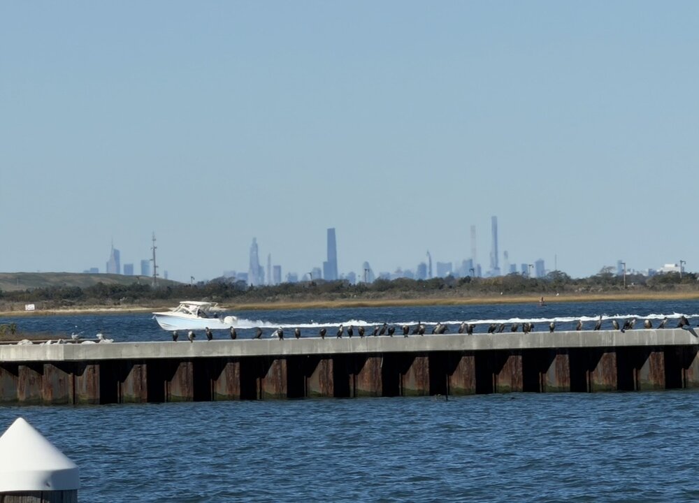
What a nice day. Down at the west end of jones beach Extremely clear
-
October 2026 OBS
WinstonSalemArlington replied to WinstonSalemArlington's topic in Southeastern States
It’s neat that we instantly have gone from a weather regime wherein highs in the 80s predominated to one wherein highs in the 60s -
2026-2027 Record-breaking El Nino
snowman19 replied to Stormchaserchuck1's topic in Weather Forecasting and Discussion
I’m not arguing, just giving my opinion. IMO that *relatively* “warm” water east of Japan isn’t going to matter as far as forcing anything, the record Nino is going to totally overwhelm it. Those “warm” North PAC waters are nowhere near as warm as the nearly 90F water in Nino region 3.4. It’s not even going to hold a candle to it and the Nino forcing is going to dominate….the latent and sensible heat release to the atmosphere isn’t comparable between the two -

2026-2027 Record-breaking El Nino
LakePaste25 replied to Stormchaserchuck1's topic in Weather Forecasting and Discussion
That’s not to say convection won’t be west of the 30C warm pool at times (i explained this a couple days ago), but i wouldn’t declare victory for winter because models aren’t showing convection maxing in 1+2, where it doesn’t really max out there to begin with. -
2026-2027 Record-breaking El Nino
LakePaste25 replied to Stormchaserchuck1's topic in Weather Forecasting and Discussion
Convection doesn’t really max out in Nino 1+2, ever. If the center of convection did, we would be talking the most east based event physically possible, rather *just* the most east based event on record. -
Euro ai shows some light rain possibly later this week and windy on the coast, but that’s likely the extent of it. Doesn’t seem too interesting here.
- Today
-
I mean we oughta know what the deal is. But I don't get why some here just can't accept somebody saying it won't snow or will be very difficult to. Soon as you say it probably won't snow *WEENIE* It feels like the same psychology as those sports fans who don't wanna hear/can't handle criticism of their team even when it is 100% true. I guess it's a "positive thoughts only!!!" kind of thing. But anyway...we all know what the deal is. Strongest niño on record, most east-based on record. I mean those are facts. A futility winter of less than 5" is very possible...but it's not like we haven't been through it twice this decade so l mean, lol Also a small possibility maybe a big storm pops but absolutely nothing to put your hat on in that regard but pure luck/timing. I mean again, these are facts, no?
-

2026-2027 Record-breaking El Nino
Keith Central PA replied to Stormchaserchuck1's topic in Weather Forecasting and Discussion
No doubt it will be warmer in December but a resonable + 5 like 82 and 97( which means it could snow)..to a 2015 December +12 gives you no chance -
2026-2027 Record-breaking El Nino
40/70 Benchmark replied to Stormchaserchuck1's topic in Weather Forecasting and Discussion
I'm going to pose this question again...which is rhetorical for me because I know the answer...identify the bonafide El Niño events with no MC forcing and a very warm Kuroshio current east of Japan. -
 Sometimes the tightness/RI *saves* and area from a bigger hit. Melissa over Jamaica was similar. If Melissa had be a long-tracked Cabo Verde, it would have been much larger when striking Jamaica. Sure, it may not have been as intense since multiple ERCs would preclude its sub-900 mb intensity, but a large Cat 4 impacting the entire island vs. only 1/3 of the islands getting Cat 3+ winds is not the same. Also, the wrn 1/3 of Jamaica is significantly less populated, and one of its main airports went largely unscathed, and the other being on the N coast on the wrn side of the island had sig less impact than if it were on the S side. Compare to Gilbert at cat 3 in Sep 1988 that cut down the full length of the Jamaica E-W w/ the entire land devastated. 80% of home lost their roofs. At least w/ Melissa on about 1/2 of the island, one could find relief, relatively speaking, short-term before full aid arrived and was distributed.
 -
2026-2027 Record-breaking El Nino
40/70 Benchmark replied to Stormchaserchuck1's topic in Weather Forecasting and Discussion
I ditched the MC idea over the summer...he misunderstood my post...in fact, the dearth of MC contribution is in integral part of my final thesis.