All Activity
- Past hour
-
The four major climate sites in Arizona on NOAA NCEI have all experienced a steep increase in summer temperatures since 1971. But the rate of increase at Phoenix for daily minimum temperatures is faster than the other sites.The increase in maximum temperatures across the four major climate sites has been fairly uniform. https://www.ncei.noaa.gov/access/monitoring/climate-at-a-glance/city/time-series/USW00003103/tmin/3/8/1971-2024?trend=true&trend_base=10&begtrendyear=1971&endtrendyear=2025&filter=true&filterType=binomial 1971-2025 Arizona increase in JJA temperatures Phoenix….min…+1.0°F/ Decade….max….+0.8°F/Decade Flagstaff…min….+0.9°F/Decade…max…..+0.5°F/Decade Tucson…..min….+0.6°F/Decade…max…..+0.8°F/Decade Yuma……..min….+0.7°F/Decade…max…..+0.8°F/Decade
-
3k NAM is really rainy for tonight and tomorrow. FV3 hires and hrrr less so, more for eastern shore.
-
1” of rain Saturday 1” of rain last evening.
-

Hurricane Erin: 130 MPH - 942mb - NW @ 12
Wannabehippie replied to BarryStantonGBP's topic in Tropical Headquarters
looking very healthy. -

Hurricane Erin: 130 MPH - 942mb - NW @ 12
wthrmn654 replied to BarryStantonGBP's topic in Tropical Headquarters
As it stands right now this thing should cross at the 70,35 if not just to the left of it , when it's going northeast ish with regards to the north east region -

E PA/NJ/DE Summer 2025 Obs/Discussion
LVblizzard replied to Hurricane Agnes's topic in Philadelphia Region
Feels like fall outside today. I could get used to this…and we will be getting used to it in the next 2 weeks. -
Hurricane Erin: 130 MPH - 942mb - NW @ 12
wthrmn654 replied to BarryStantonGBP's topic in Tropical Headquarters
-
Blue sky and sun wooohoo
-
I mean yeah you’ll be a few cooler but I think it will be warm overall.
-
 It's weird to see Hudson Bay below normal, what caused that this year?
 -
Hurricane Erin: 130 MPH - 942mb - NW @ 12
wthrmn654 replied to BarryStantonGBP's topic in Tropical Headquarters
Tail doppler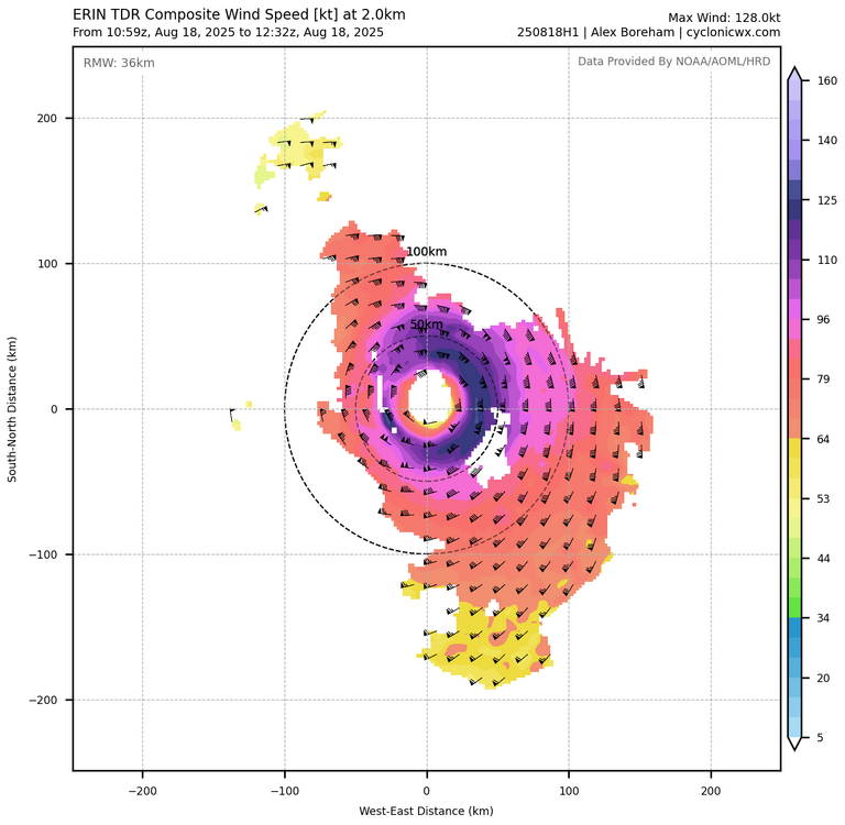
-

Hurricane Erin: 130 MPH - 942mb - NW @ 12
olafminesaw replied to BarryStantonGBP's topic in Tropical Headquarters
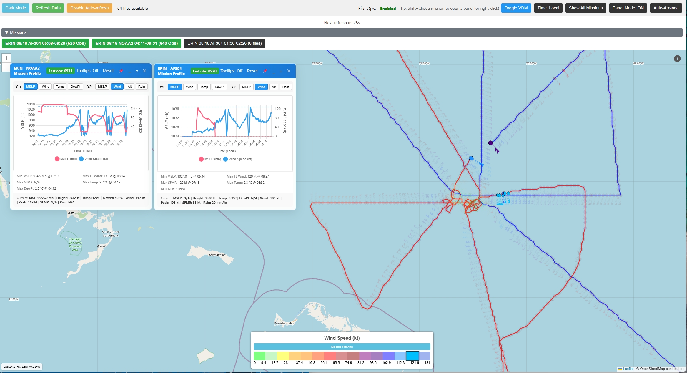
This is phenomenal! My only feedback so far is it would be nice to have a little dot that shows you what you are selecting on the interactive graph that moves with your cursor. I agree that optimized for mobile would be nice too, but this is so much more detailed than the TT site (if a little more visually cluttered). The nicest new feature is being able to see all the center fixes history. Will be super helpful for judging storm motion, especially for land falling hurricanes -

Hurricane Erin: 130 MPH - 942mb - NW @ 12
Kevin Reilly replied to BarryStantonGBP's topic in Tropical Headquarters
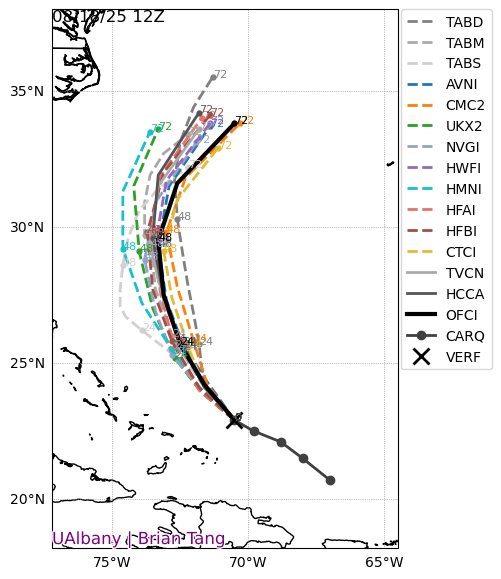
I think but I am not sure (just looking to learn) is the trough upper air disturbance here in the Northern Mid-Atlantic the thing that will kick Erin east? Or perhaps this has nothing to do with the steering currents for future Erin. I mean here the weather forecast has been majorly blown today at very short leads. It was supposed to be Mostly Cloudy and 73f here today 0% of rain. Reality it is 62f humidity 96% dewpoint 62f with a northeast wind. It has been light rain and drizzle since 7:15 am rain moving NE to SW here. I am wondering if the models are missing something with this system that could affect the track of Erin way to our south? Thanks for feedback and comments. -
Congrats. Hopefully it’s a strong niño.
-
Hurricane Erin: 130 MPH - 942mb - NW @ 12
wthrmn654 replied to BarryStantonGBP's topic in Tropical Headquarters
Works way better on a computer then a phone ID guess lol horrible on a phone from what I can see just looking at it quickly versus your photo -
 Erin;s wake cooling things a bit - we'll see how this looks next week
 -
Thanks, Don technically (due to ties) EWR: 90 degree days: 38 (7th place) 95 degree days: 14 (7th place) 100 degree days: 7 (3rd place) Year Rank Days >= 100 °F 1993 1 9 1949 2 8 2025 3 7 2022 4 6 1953 4 6 1988 5 5 1966 5 5 Year Rank Days >= 95 °F 1993 1 25 2010 2 21 2022 3 20 1988 3 20 1944 3 20 2021 4 18 2012 5 17 2011 5 17 2002 5 17 1955 5 17 1949 6 16 2005 7 14 1953 7 14 2025 7 14 Year Rank Days >= 90 °F 2010 1 54 2022 2 49 1993 2 49 1988 3 43 2021 4 41 2002 4 41 1991 4 41 2016 5 40 1983 5 40 1959 5 40 1994 6 39 1944 6 39 2025 7 38
-

Hurricane Erin: 130 MPH - 942mb - NW @ 12
FredRed replied to BarryStantonGBP's topic in Tropical Headquarters
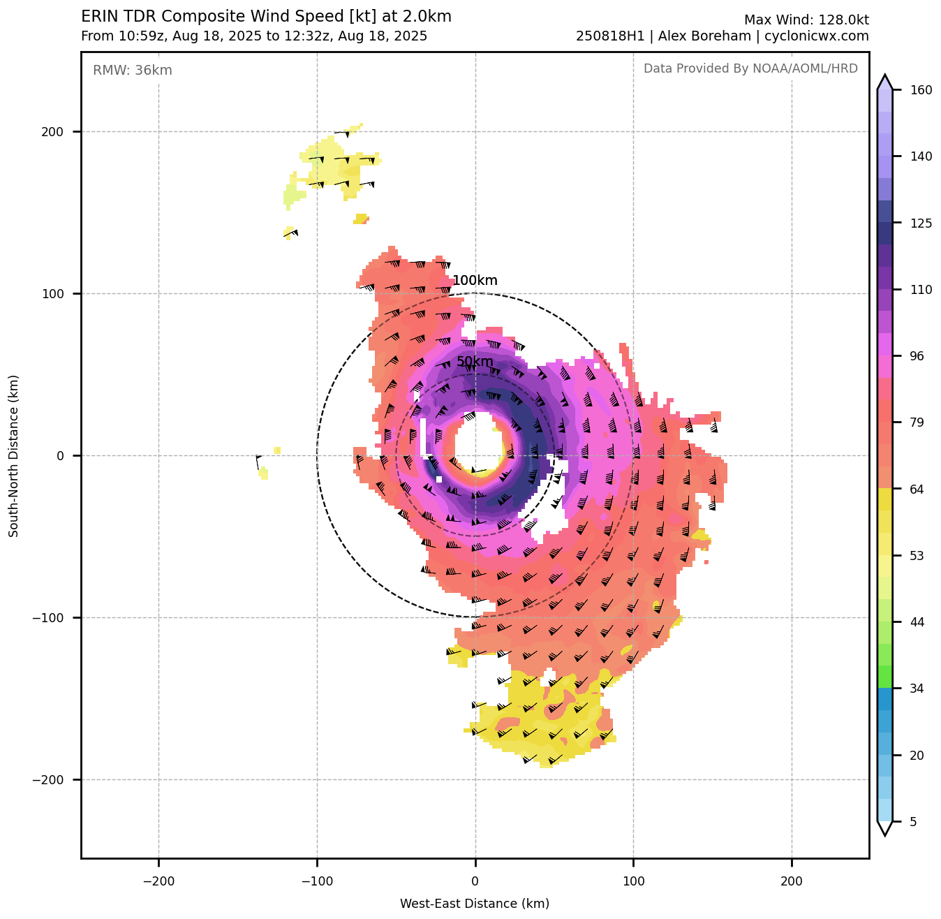
New Recon viewer! Curious if y'all find it useful. Let me know if you have see any bugs or would like some new features. https://hurricane-recon-viewer.replit.app/ Interactive flight paths with color-coded wind barbs Mission profile graphs (MSLP, winds, temp, dewpoint) Dynamic wind speed filtering & legend scaling Auto-refresh every 2 min for latest obs Multi-panel mode for mission comparison SFMR, flight-level winds, and surface pressure analysis Real-time mission status with recency indicators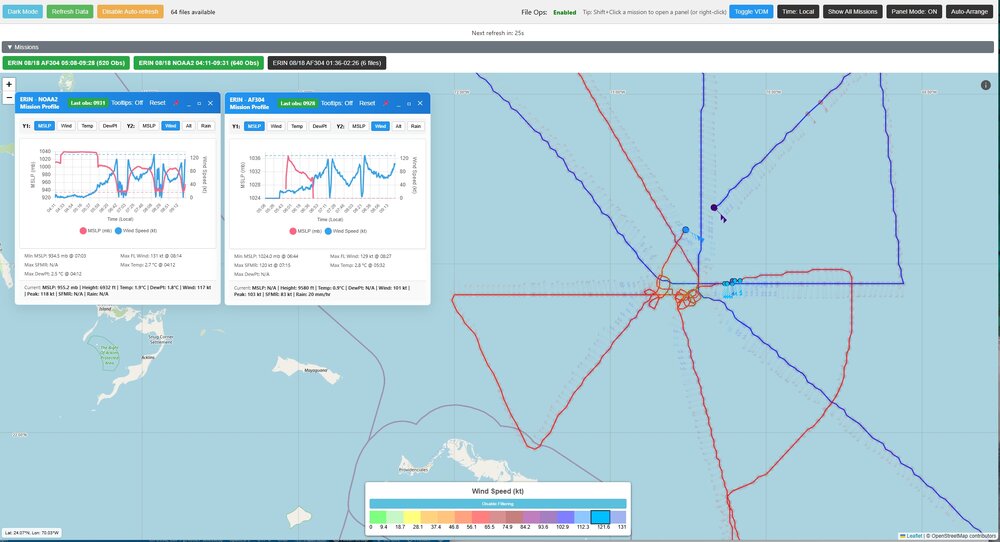
-
checked the gauge and surprisingly picked up 0.67" with the FP yesterday.
-
 Same Beautiful
 -

Occasional Thoughts on Climate Change
TheClimateChanger replied to donsutherland1's topic in Climate Change
What is the website to generate these graphs? -
Occasional Thoughts on Climate Change
TheClimateChanger replied to donsutherland1's topic in Climate Change
-
No skin in the game, but its basically a slow step down from here as we approach late August. There will be still be hot days thrown in though, and definitely humid stretches through Halloween.
-

2025 Short Range Severe Weather Discussion
A-L-E-K replied to Chicago Storm's topic in Lakes/Ohio Valley
def feels juiced, time to wait and see how timing and clouds play out -
We'll see how low these go over the next 14 days Aug dep through 8/17 EWR: +0 NYC: -0.2 JFK: -0.9 LGA: -1.0