All Activity
- Past hour
-
Rain has finally moved in. Picked up .42" so far.
-
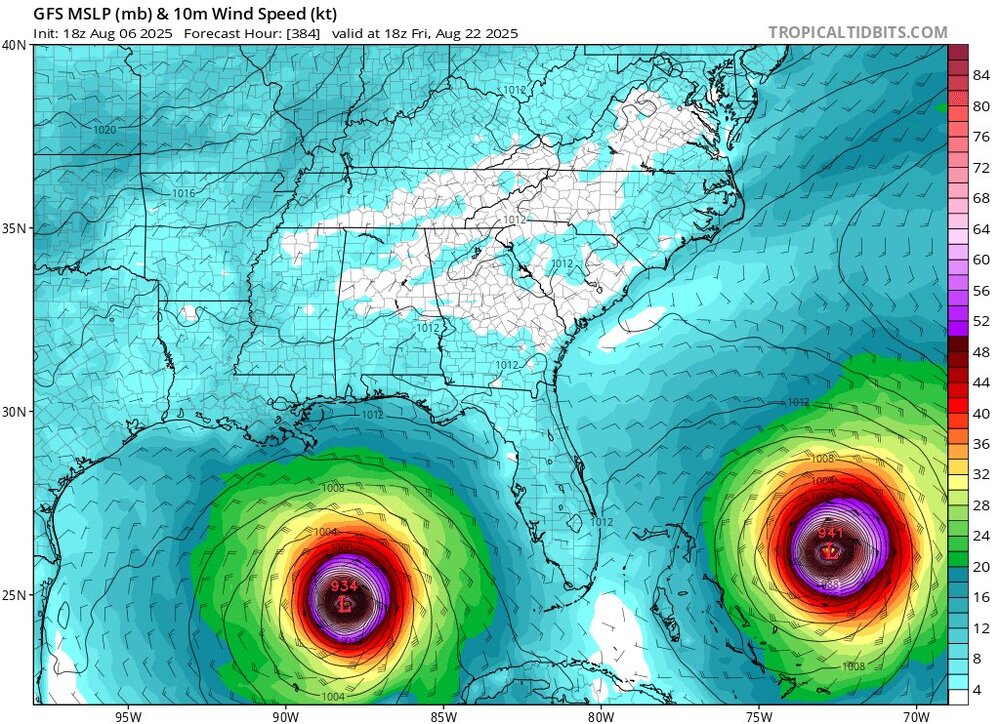
 End of the GFS run is really funny.
 -

2025 Atlantic Hurricane Season
BarryStantonGBP replied to BarryStantonGBP's topic in Tropical Headquarters
I mean, the switch flipped somewhat early this year -

2025-2026 ENSO
so_whats_happening replied to 40/70 Benchmark's topic in Weather Forecasting and Discussion
Legitimately if this had not started out as one of the lowest winter time volumes recorded this would have been an amazing retention year. The pattern was damn near perfect to lock in ice and cooler temps. The biggest help has been the lack of Canadian warmth up to the Archipelago. I don't even think the NW passage will open this year given we have about 3-4 weeks left of melt, unless this pattern completely flips on us. -
I believe it
-
I'm ready for Blizzard Warnings already lol
-
 In the third world country that is the US the answer is yes. How is a scientific fact politics
 -

2025 Atlantic Hurricane Season
Floydbuster replied to BarryStantonGBP's topic in Tropical Headquarters
Some of the accounts on weather platforms are getting too caviler and cocky in their eyerolls about the GFS. We are in August during what should be a favorable MJO phase and *unlike last year* models show a ton of activity in the coming weeks. The fact that model runs from the GFS to the EURO have shown significant hurricanes after mid August is very troublesome, especially since they have been consistent. Be ready, it is on the way. -
oh wow, radar says Jonesville next to Hillsdale got 3-5". That's insane from such a random shower type of a weather pattern!
-
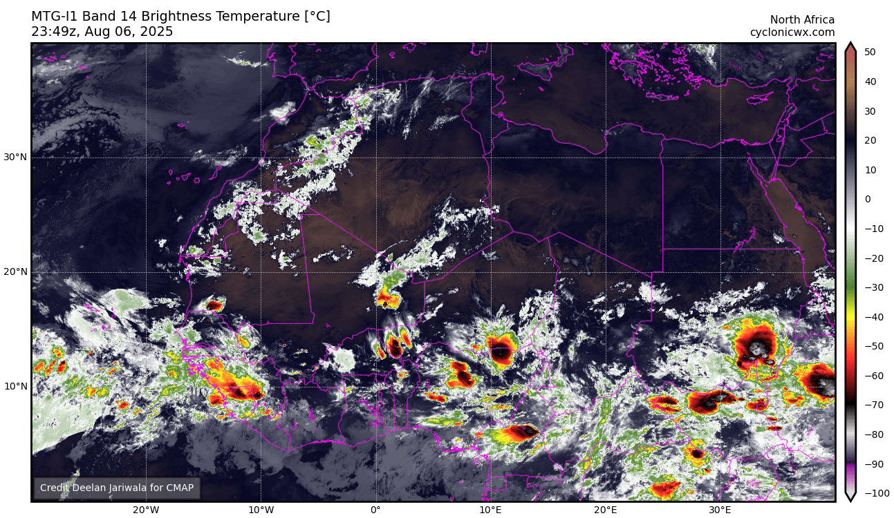
TROPICAL WAVE LOCATED IN CHAD, AFRICA (NOT 96L)
BarryStantonGBP replied to BarryStantonGBP's topic in Tropical Headquarters
oui oui baguette -
SE Area of Interest--10% two day, 30% five day odds
BarryStantonGBP replied to WxWatcher007's topic in Tropical Headquarters
Are you leaning for or against TC genesis? -
THIS WAVE HASN'T SPLASHED DOWN YET BUT DESERVES ITS OWN THREAD ANYWAY POST MODEL RUNS HERE

-
Cuba looks like a crooked nose in between two crazy eyes. Too bad it couldn't be some dumb twin names like Hurricane Bert and Ernie.
-

SE Area of Interest--10% two day, 30% five day odds
WxWatcher007 replied to WxWatcher007's topic in Tropical Headquarters
Yeah, but I’m not necessarily tracking for US impacts anymore—more for how TC genesis occurs or not in this case. -
2025 Atlantic Hurricane Season
Blizzard-on-GFS replied to BarryStantonGBP's topic in Tropical Headquarters
lmao you beat me to it! I was about to post this hahah. Day After Tomorrow Vibes! -
2025 Atlantic Hurricane Season
BarryStantonGBP replied to BarryStantonGBP's topic in Tropical Headquarters
"You need to provide your ID to view this content" -

SE Area of Interest--10% two day, 30% five day odds
Kevin Reilly replied to WxWatcher007's topic in Tropical Headquarters
Ehh even if that develops it will just ease off to the east and east northeast once it gets to the latitude of say Cape Fear NC. - Today
-
 Few drops here. Looks like a dry stretch coming up before the next heat wave which will help it get hotter.
 -
I had my 20th storm of 2025 this aft but it sort of went to my east, just got sprinkles and long, soft rolling thunder for 30 mins. 140 strikes. It was the very rare due south dir cells. Crickets started yesterday. Mostly cloudy today and with all the smoke its becoming less sunny now, oof!! That 10 day last week showing mostly sunny for the next period here really busted not just for smoke blot but typical cloudiness.
-
You know what? It’s 2025. Let’s do this. Let’s push FEMA and the NWS to their breaking points and see how that goes.
-
Unfortunately they usually cut the bone and leave the fat. Nothing fun about seeing 'ol Bill, the 30 year DBA being escorted from the building laptop in hand. The one guy who could still read machine code!
-
Or there is Skynet, which absolutely wrecks Cuban agriculture across the entire island.
-
 Highs: ISP: 81 EWR: 80 JFK: 80 ACY: 80 TEB: 79 PHL: 79 NYC: 79 LGA: 78 New Brnswck: 76 BLM: 75 TTN: 75
 -
SE Area of Interest--10% two day, 30% five day odds
BarryStantonGBP replied to WxWatcher007's topic in Tropical Headquarters
So probably we could get a TD but no TS? -
You guys are such goobers First of all if that set up that way to the west system would curve down into Mexico and the east system a curve out to sea. So yeah, hopefully the media made a big deal out of a double hit and then that happens