All Activity
- Past hour
-

2026-2027 Record-breaking El Nino
Jebman replied to Stormchaserchuck1's topic in Weather Forecasting and Discussion
So it IS true we are seeing some influence from the Nino in the CONUS? This link is interesting. https://atlas.niu.edu/gwo/ -
A ton of rain tonight and much more coming. A very nice surprise this evening and tonight to pick up several inches of rainfall.
-
 https://psl.noaa.gov/data/correlation/qbo.data goes back to 1948 monthly at just 30mb but was done being updated with a lot of other things back at the end of February 2026. Also have this pdf from awhile back again unfortunately have not seen this updated in a long time https://www.geo.fu-berlin.de/met/ag/strat/produkte/qbo/qbo_wind_pdf.pdf Updated site for ^^^ https://www.atmohub.kit.edu/english/807.php
 -
 http://mapletrustrx.com/# canadian pharmacy 365
 -

Augdewst 2026: Summer's Last Stand
vortex95 replied to Prismshine Productions's topic in New England
Pffttt! Lame X post. He does not specify how *strong* El Nino was those years. That makes a big difference. And there have been 10 El Nino events since 1994, so where are the other 7 for comparison? 2002-03 was strong El Nino. How did that winter do? /S 2009-10 was strong El Nino, what happened that winter? /S We should be looking at very strong El Ninos only. We've have 4 since the 1950s, 1982-83, 1991-92, 1997-98, 2015-16. It is a mixed bag, leaning toward below avg snowfall, but there was the Feb 1983 blockbuster and also Jan 2016. So it does not mean it is a complete loss. Also, sample size, 4 very strong El Ninos in 70 years does not tell us the full gamut of what can happen, so don't let the @CoastalWxDebbie Downer attitude rule here! There are no less than a dozen other global and regional oscillations going on and how they interact w/ El Nino can and does lead to the unexpected. Case in point, normally in very strong El Nino, Cali is soaked and the Pac NW is dry. Well, that did not occur in 2015-16, it was the exact opposite! Also, the wx/atmosphere does not work linearly. In other words, just b/c this may be the strongest El Nino in modern times, does not mean you simply extrapolate in one direction based off other very strong events, esp. when it comes to regional sensible wx and the specifics. -
 You can actually make your own custom index, factoring in global warming, which is about +0.2-3 for Nino 3.4. In other words, 0.0 neutral is now with global warming +0.2-3. The point of RONI is to even it out, so you can track mid latitude influences more, but there are a lot of extra guidelines with it I think that make it vary month-to-month. Just factoring in global warming skew is helpful for seeing what pure ENSO event is like. On the seasonal model forecasts, it usually shows the timeframe somewhere on the top of the map. It's usually 1 month, or 3-months. The CPC officially uses RONI: Climate Prediction Center - CPC adopts Relative Oceanic Niño Index (RONI) for reliable, responsive monitoring and tracking of ENSO
 -
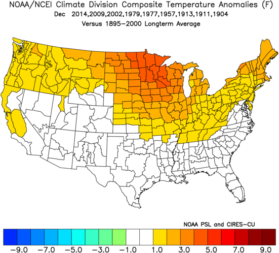
^QBO data only goes back to 1979, but add that and Dec is even warmer! I'm really curious to see what this Dec will look like.
- Today
-
top 10 pharmacies in india: Trust Pharma India - Trust Pharma India
-
Augdewst 2026: Summer's Last Stand
vortex95 replied to Prismshine Productions's topic in New England
Likely a rain-wrapped tor. If it was a MB that strong to flip cars, the other ones nearby would have at least been pushed sideways. Nothing I find more frightening in wx is not having good VIS when a tor may be present. I've been in that situation before in OK (the day of the El Reno monster in May 2013), and it was a harrowing experience to say the least. -

Spring/Summer 2026 Pattern Discussion Thread
John1122 replied to Carvers Gap's topic in Tennessee Valley
Picked up 1.5 inches as of midnight. It's still pouring down here. All lightning and thunder seem to have moved out over the last 30 minutes. -
Going to be some big rainfall rates in the morning. Looks like a ton of moisture setting up to.come across WNC.
-
2026 Atlantic Hurricane Season
vortex95 replied to Stormchaserchuck1's topic in Tropical Headquarters
The wind shear "barrier" along 20N is quite impressive. So 92L and what is behind it don't stand a chance once they gain more latitude. 93L well to the N in the basin is likely a TD/weak TS now. Sheared, but LLCC has become more defined and convection is persisting E of the center, plus its fast forward motion is likely augmenting the winds on the S quad. NHC gives it 40/40 but it could be declared at any time. It's small and will not last long if it becomes a TC.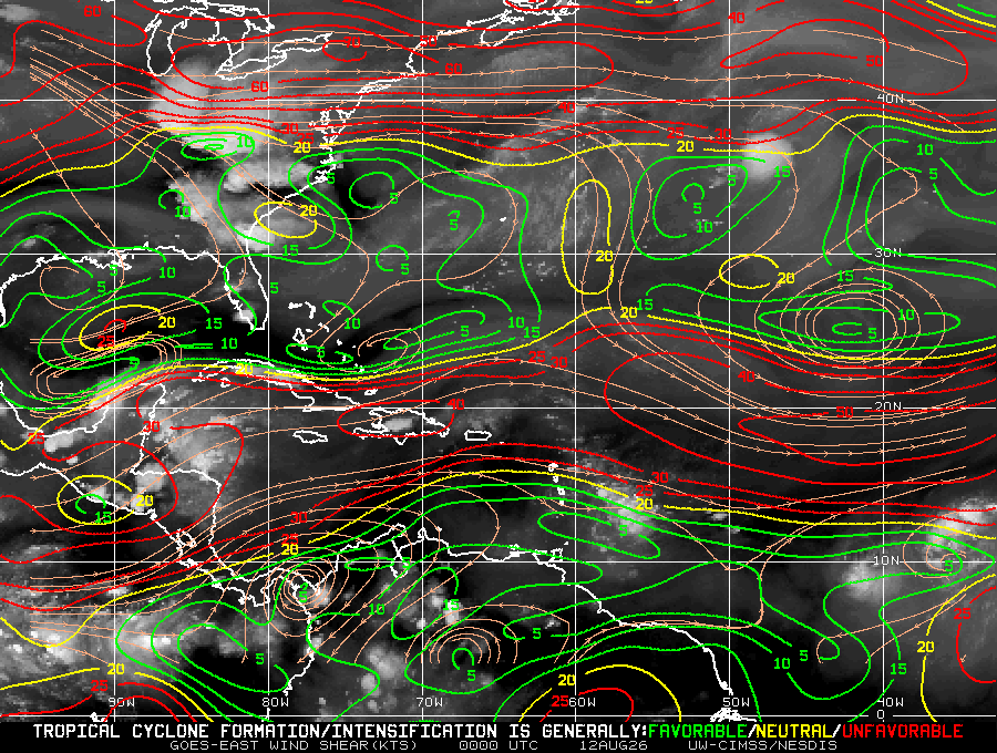
-

2026-2027 Record-breaking El Nino
GaWx replied to Stormchaserchuck1's topic in Weather Forecasting and Discussion
Here’s the mean of the 9 Decembers preceding these very cold Nino Febs: like night and day! Look familiar?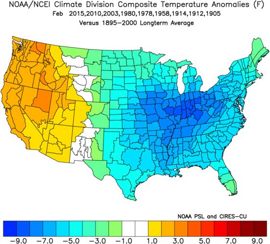
-
LOLLLLL. https://x.com/bigjoebastardi/status/2087382965235982682?s=46
-
2026-2027 Record-breaking El Nino
GaWx replied to Stormchaserchuck1's topic in Weather Forecasting and Discussion
It is usually either a 3 month or a 1 month avg. -

2026-2027 Record-breaking El Nino
Nomz replied to Stormchaserchuck1's topic in Weather Forecasting and Discussion
Hey y'all. Pretty new to long-range forecasting; had a couple random questions I couldn't get a good answer on: When someone says a model is spitting out a peak of +4.5, for example, is that a single-day peak or a three-month average, as tracked by the NWS? Are we generally discussing RONI or ONI, and which is more predictive? (Does it change with seasons?) -

Spring/Summer 2026 Pattern Discussion Thread
Matthew70 replied to Carvers Gap's topic in Tennessee Valley
I hope all you east TN folks are safe. Here in the Boro I am seeing a lightning storm I have not seen in a very long time. Beautiful but also very scary. It’s constant streaks. -
Mosquito larvae don't care about cold. If you've ever been to the Minnesota or Canadian Northwoods or Alaska in summer you're gonna get swarmed. The joke in Alaska is you need a frying pan to kill them they're so big. And those locations get down to -40 and below. I do know that Mosquito spawning cycles are temperature and moisture dependent but I'm not knowledgeable beyond that.
-
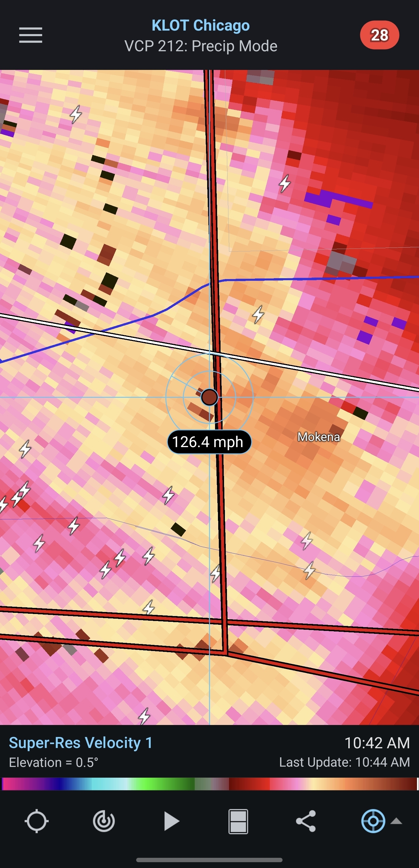
So Illinois will likely surpass the 200 tornado mark with today's action. What would be interesting is to guess how many Illinois tornadoes will occur in 2027. Would make for a fun poll thread.
-
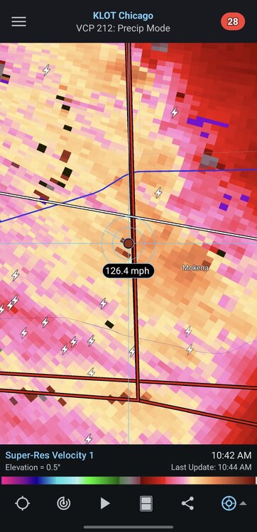
Confirmed EF1 for Mokena
-
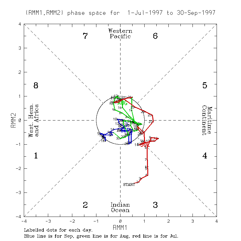
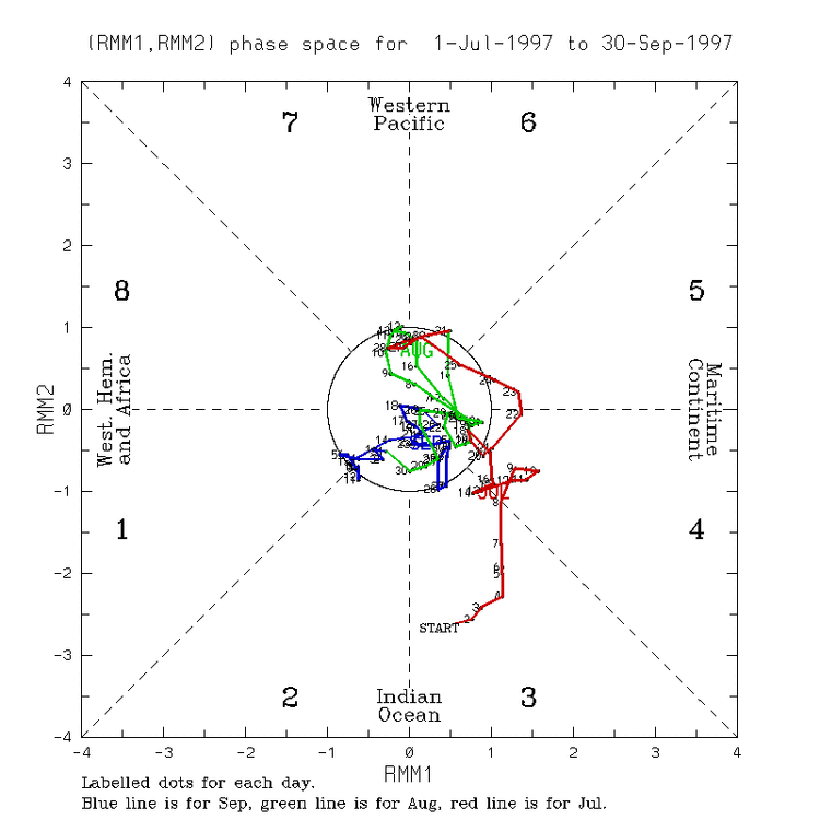
It is also very interesting to see the MJO just stuck in Phase 6 for nearly a month (with the forecast through the 25th). https://www.cpc.ncep.noaa.gov/products/precip/CWlink/MJO/CLIVAR/clivar_wh.shtml Looking back at 97-98 we were null to even having a La Nina-esque lean to the MJO through summer, I get it less influential in the summer. https://www.bom.gov.au/climate/mjo/#tabs=Monitoring Unfortunately with the cuts to data I can not find reanalysis of VP to prior time periods to match with current times, since current times are not being updated.
-
2026-2027 Record-breaking El Nino
GaWx replied to Stormchaserchuck1's topic in Weather Forecasting and Discussion
Thanks, Chuck. The quite cold E US Nino Febs I’m aware of are 2015, 2010, 2003, 1980, 1978, 1958, 1914, 1912, 1905, 1889, and 1885.
-
Let's save that for Dec 20th - Feb 10th. I'm all for a warm November then we can flip just in time for Christmas and enjoy a nice snowfall for the holidays.
-
If combined they may elevate the gelatin Vienna sausages
-
Nice.