All Activity
- Past hour
-
They didn't salt the hell out of the roads like now. We used to sled on our street for weeks back then.
-
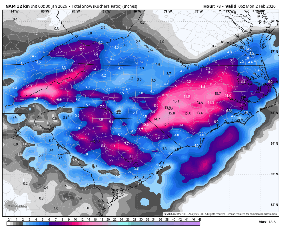
NAM is a huge improvement. gets 5-6 into SEVA and the snow line has moved alot NW to the doorstep of RIC
-

The “I bring the mojo” Jan 30-Feb 1 potential winter storm
chris624wx replied to lilj4425's topic in Southeastern States
yeah, don't love that for SEVA -
Thanks so much @donsutherland1 I was always envious that my cousins near W-B got more snow than in my hometown. lol
-

The “I bring the mojo” Jan 30-Feb 1 potential winter storm
Ravens94 replied to lilj4425's topic in Southeastern States
.thumb.png.f33bc6c38f589f2c09b02d79c9ab2943.png)
-
The “I bring the mojo” Jan 30-Feb 1 potential winter storm
wake4est replied to lilj4425's topic in Southeastern States

-
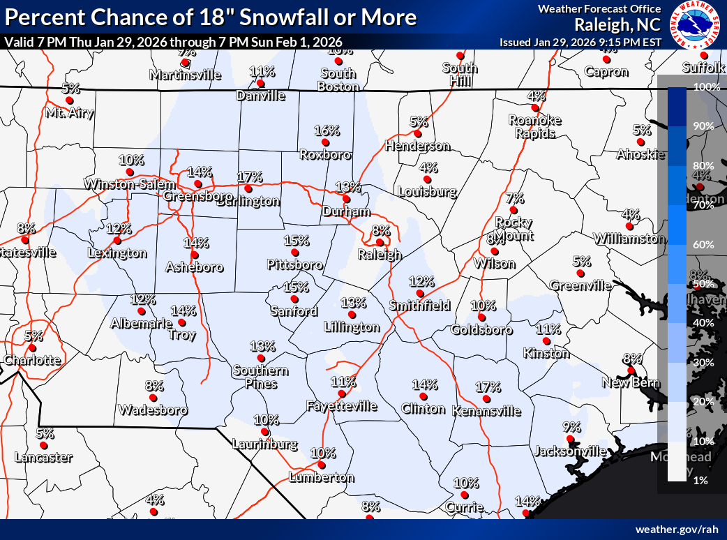
Looks just lame altogether other than a 75 mile wide strip near the Tidewater and E NC. 0.3” liquid as snow for Raleigh is notable and I think a warning event down there but nothing historic.
-
We need to be as close to that ULL as possible. Compare the positions of the ULL on runs we like vs runs we don’t. She’s getting a bit too far south now.
-
Confession. I am the one who actually puts out the NBM with a secret snow formula
-

Winter cancelled/uncancelled banter 25/26
WeatherGeek2025 replied to Rjay's topic in New York City Metro
deal! i'll be here blabbing -
Its crazy how the convection is so pronounced and widespread it creates it own cold pool and shreds apart the ULL over the coast Wild
-
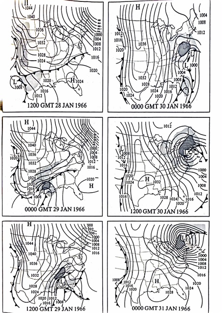
From the KU books: The trough went negative and the storm wound up tracking inland relative to NYC.
-
The 0z NBM was pretty much a repeat of the 18z. Gonna see what models they used. It literally has 1/2 inch for me.
-

The “I bring the mojo” Jan 30-Feb 1 potential winter storm
AGardiner87 replied to lilj4425's topic in Southeastern States

-
I thought digging would help negate downsloping but now I'm not so sure
-

E PA/NJ/DE Winter 2025-26 Obs/Discussion
Newman replied to LVblizzard's topic in Philadelphia Region
Ha, I would love to hear his thoughts. I actually have no real issue with the NBM being used as a basis for the NDFD grids. In fact, I believe that's what it's really for. I just don't like how you can tell some WFOs get lazy and just send out the NBM or MOS guidance verbatim without even trying to input real climo or meteorological expertise. Also, speaking with the NWS Miami met, the NBM is being pushed programmatically in a way that it's not mandatory yet but highly encouraged. Let's be real here, what NWP guidance is even getting snow showers back to the I-95 corridor? I'd imagine very very few, and those that are are coming from the perturbed ensemble guidance like the GEFS, EPS, SREFs, etc. So right away I can tell you this forecast is heavily weighted by the NBM (which inputs those into it). In reality it could actually be a good forecast, if we believe the inevitable NW trend that hasn't commenced on guidance yet will occur so in that I give NWS Mount Holly plenty of kudos for not just sticking to the deterministic GFS and Euro. But also, I don't see any way it snows back to I-95 this weekend outside of a miracle personally..thumb.png.5d0d208b9cd380111bfe6246d0c77cae.png)
-
The regular NAM but I don't trust it. Honestly riding the EURO. it's been very consistent the past few days. Sent from my SM-G998U using Tapatalk
.thumb.jpg.d401ea903d987802a9f7a0880a788550.jpg)
-
SREF as well
-

The Jan 31 Potential: Stormtracker Failure or 'Tracker Trouncing
WEATHER53 replied to stormtracker's topic in Mid Atlantic
I’m just curious about that nice looking cloud stream from the pacific into west Texas? -
The “I bring the mojo” Jan 30-Feb 1 potential winter storm
digital snow replied to lilj4425's topic in Southeastern States
Getting spicy!
-

The “I bring the mojo” Jan 30-Feb 1 potential winter storm
ADB83 replied to lilj4425's topic in Southeastern States
If you’re in the Triad, you’re rooting hard for the HRRR. If the NAM verifies we’re the big losers (but still with 3 inches of snow [emoji4]) . -
00z offers little help at the onset for any snow flakes NAM
-

Richmond Metro/Hampton Roads Area Discussion
wasnow215 replied to RIC Airport's topic in Mid Atlantic
How can a "blend of models" get higher totals than the model that shows the most snow lol. Makes no sense. It's like saying 0+2+0+4+1 divided by 5 equals 5 -
The “I bring the mojo” Jan 30-Feb 1 potential winter storm
Ravens94 replied to lilj4425's topic in Southeastern States
Man the fv3 is just ... -
I'll say this. I have rarely seen the Euro bust badly from 24-36 hours out. Granted, it's normally being dr no at this range. But it's normally excellent with QPF at this range. Also keep in mind, the Euro us a high resolution model essentially. It's resolution is better than the 12k nam by quite a bit.
- 476 replies
-
- 1
-

-
- extreme cold
- snow
- (and 1 more)


.png.3bac259e81eeb13d6c95cc65255e4f11.png)


.png.b8bd1739341fca22561627c8000f09ab.png)

.jpg.ca669752ad2c9b5daafd576f98b3d12b.jpg)