All Activity
- Past hour
-
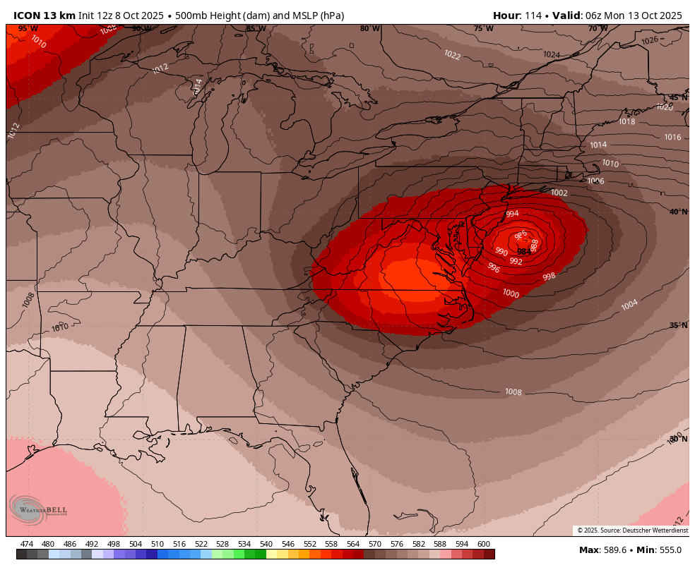
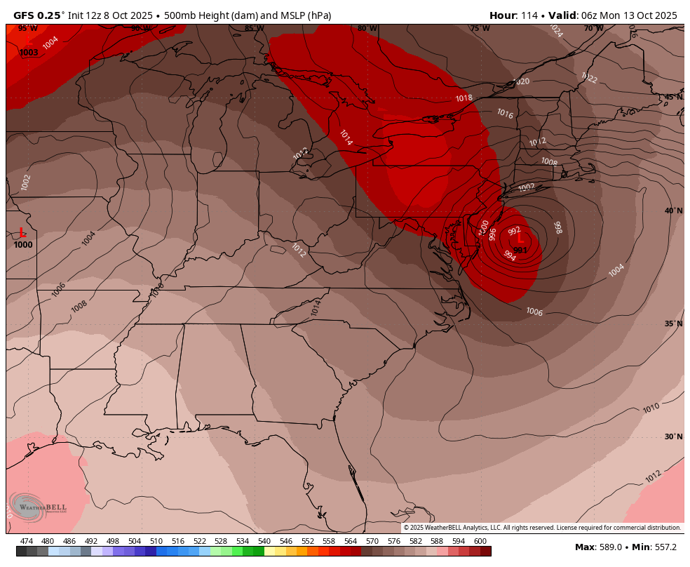
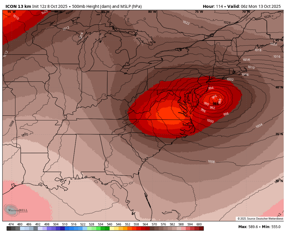
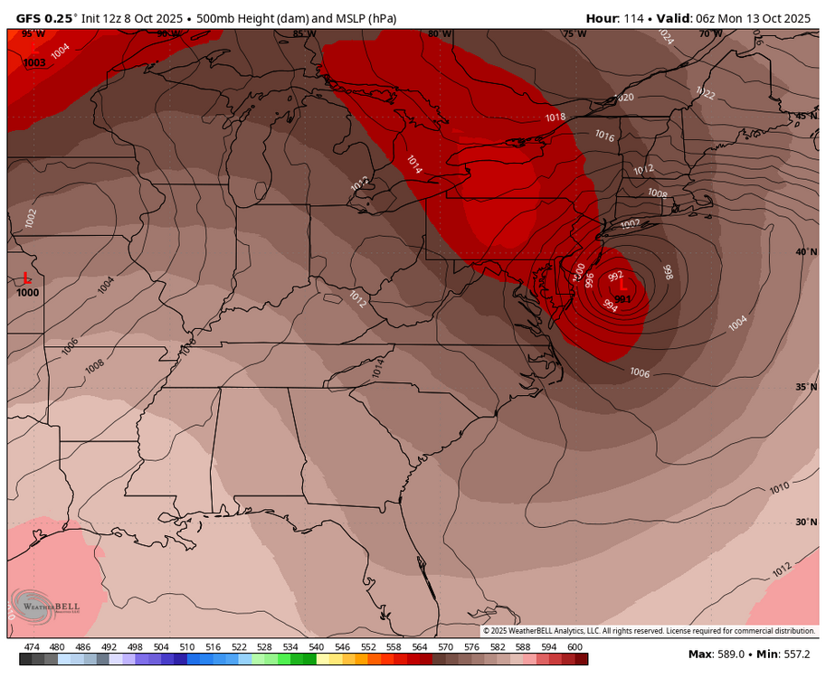
WB 12Z ICON upper level low track is much further SE and stronger than the GFS.
-
whats the latest that either or both had 4 consecutive 80 degree highs Don? I noticed the records for the date were from 1944 and 1949, both years had endless summers.
-
NYC adjusted upward? The evening news said the high at NYC was 79
-
80s isn't hot though (especially with low humidity) In my experience we get our first 80s by April and our first 90s by June. Our last 90s are normally in early September and our last 80s are normally in mid or late September.
-
this sentence is a lie, a lie which is exposed in the very next sentence (if anyone read it) The law DOES NOT REQUIRE homeowners to paint their roof white, it requires that new and replacement roofs, in order to be permitted by the municipality, be constructed to meet an updated building code requirement just another example of how the right misuses words and language to confuse people and get them to believe something that isn't true
-
000 SXUS71 KILN 080538 RERDAY RECORD EVENT REPORT NATIONAL WEATHER SERVICE WILMINGTON OH 138 AM EDT WED OCT 08 2025 ...RECORD DAILY MAXIMUM RAINFALL SET AT DAYTON OH... A RECORD DAILY MAXIMUM RAINFALL WAS SET AT DAYTON OHIO ON OCTOBER 7. A TOTAL OF 2.45 INCHES OF RAINFALL WAS RECORDED. THIS BREAKS THE OLD RECORD FOR OCT 7 OF 1.72 INCHES...SET IN 1931. $$ HATZOS Biblical soaker, for sure. That much rain in one day during the first days of October, is this a harbinger of what's to come later in the month?
-
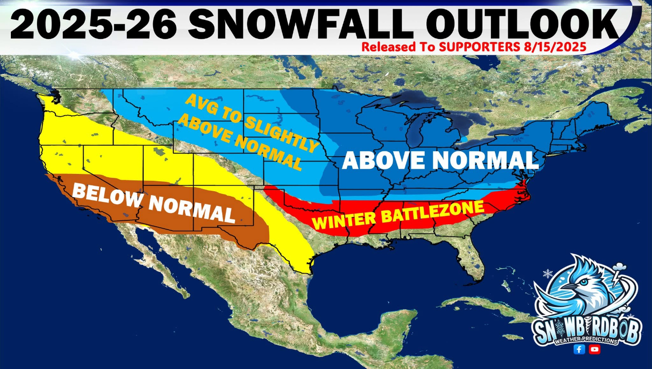
LFG!! I don’t who this guy is, but maybe @JI in disguise? “SNOWBIRDBOB WEATHER PREDICTIONS — FINAL 2025–26 SNOWFALL OUTLOOK (Updated Oct 1st) We’ve been digging deep into global weather patterns, ENSO signals, analog years, and long-range model data, and today we’re releasing our final snowfall outlook for Winter 2025–26. Here’s what we’re expecting: Above Normal Snowfall: Much of the Upper Midwest, Great Lakes, Ohio Valley, Mid-Atlantic, and interior Northeast is favored to see a snowy winter. Frequent storm tracks and strong cold intrusions will fuel above normal totals, with some areas possibly seeing significantly above normal snowfall. The Winter Battle Zone: From Central Arkansas through Tennessee, into the Carolinas and Virginia, this is the corridor where warm Gulf moisture and frequent Arctic fronts collide. These areas will see a mix of ice, snow, and wintry messes, and frequent roller coaster ride of weather and temps. Average to Slightly Above Normal: Across the northern Plains into the northern Rockies, snowfall should be close to normal, with some areas leaning above normal depending on storm track alignment. Below Normal Snowfall: The Southwest U.S., southern Plains, and much of California into Nevada are projected to see below average snowfall. This region will likely lean drier overall with less cold air intrusion. The Big Drivers: A Neutral ENSO with a brief dip toward weak La Niña early winter before balancing back to neutral. Strong blocking signals showing up in the high latitudes at times, which could drive cold outbreaks into the central & eastern U.S. Past analog winters (2013–14, 2014–15, 2017–18, 2019–20, and 2024–25) line up well with this year’s setup. Bottom line: If you’re in the Midwest, Great Lakes, Ohio Valley, or Northeast, get those shovels ready. If you’re in the Winter Battle Zone, prepare for some wild storms with snow & ice mixing in”

-
Sun poking out here-down to 59
-
How many tide cycles? We're just coming off the full super moon too. They're calling it a super Harvest Moon but I thought that only happens in September?
-
Wild, the Tunguska impact happened in 1908, could that have had an effect?
-

Spooky Season (October Disco Thread)
40/70 Benchmark replied to Prismshine Productions's topic in New England
I think the analog does have some utility....it's a great ENSO analog....but there are also some glaring limitations; namely the solar cycle and the western Pacific. -
I’m rooting for the icon this weekend if only to see if my sump pump still works.
-
I’m already booking my January beach blizzard.
-
You cannot compare the water levels of Lake Champlain with today due to the fact that domestic water use has doubled since that time and population growth has increased as well. Yes, it’s been dry but everything balances out. .
-
61 with strong breeze, feels like 56 sitting outside.
-
1.87 final
-
Bring on the storm. Love being down on the boat during a bad storm. At the dock of course
-
Looks and feels like a White Chicken Chili kind of night.
-
12z GFS continuing the theme...maybe even a bit more stout with wind potential, even inland to the Pike. edit: nvm...its status quo, maybe a tad weaker. I still had 6z up
-
Over several high tide cycles. Verbatim that is a major coastal erosion / flooding event.
-

Spooky Season (October Disco Thread)
CoastalWx replied to Prismshine Productions's topic in New England
Looks like Ray is implying a 100" winter for BOS. Sweet. -
0.25 all said and done
-
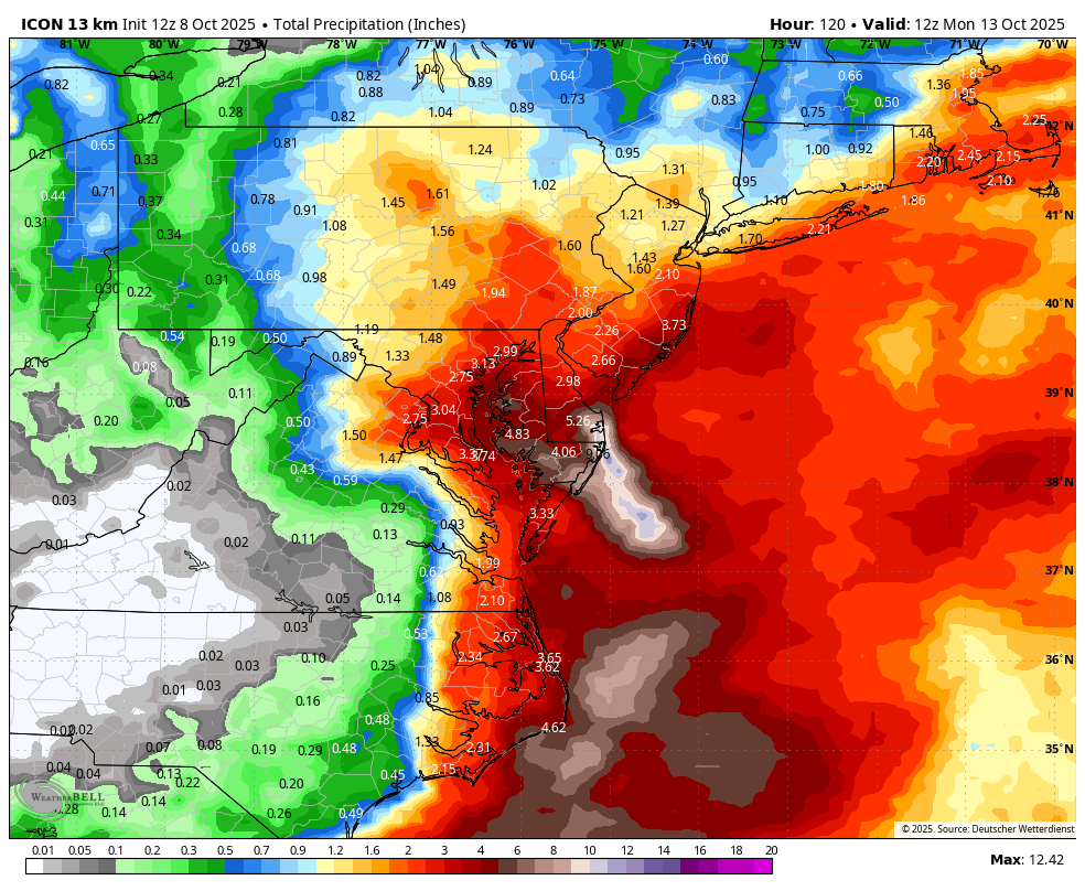
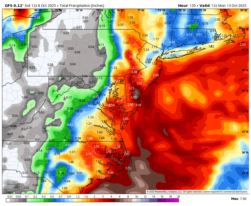
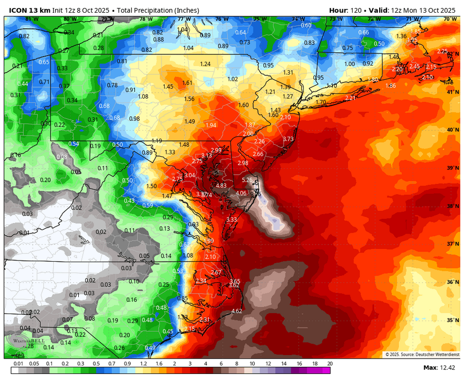
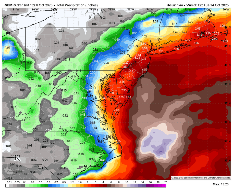
WB 12Z Day 5 rain totals for the globals. ICON (shifted back west); GFS still DC eastward; Canadian is Day 6 because it is slower.

-
Sandy track but way less impact than that storm. This will still cause beach erosion and flooding.
-
Spooky Season (October Disco Thread)
40/70 Benchmark replied to Prismshine Productions's topic in New England