All Activity
- Past hour
-
(002).thumb.png.6e3d9d46bca5fe41aab7a74871dd8af8.png)
Central PA Winter 25/26 Discussion and Obs
ChescoWx replied to MAG5035's topic in Upstate New York/Pennsylvania
Merry Christmas to all of you! Dry and breezy with near normal temperatures today a slight chance of a shower or snow flurry tomorrow morning and then a significant winter event for the entire area by later Friday. This will not be a significant snow event but will be impactful with mixed precipitation that falls occurring with temperatures mainly in the mid to upper 20's. I suspect the predominant precipitation type will be sleet with increasing chances of freezing rain further south and more snow especially as we go north and east toward Trenton and NYC. Rain returns on Sunday night and we turn sharply colder again on Monday.
-
E PA/NJ/DE Winter 2025-26 Obs/Discussion
ChescoWx replied to LVblizzard's topic in Philadelphia Region
Merry Christmas to all of you! Dry and breezy with near normal temperatures today a slight chance of a shower or snow flurry tomorrow morning and then a significant winter event for the entire area by later Friday. This will not be a significant snow event but will be impactful with mixed precipitation that falls occurring with temperatures mainly in the mid to upper 20's. I suspect the predominant precipitation type will be sleet with increasing chances of freezing rain further south and more snow especially as we go north and east toward Trenton and NYC. Rain returns on Sunday night and we turn sharply colder again on Monday.
-
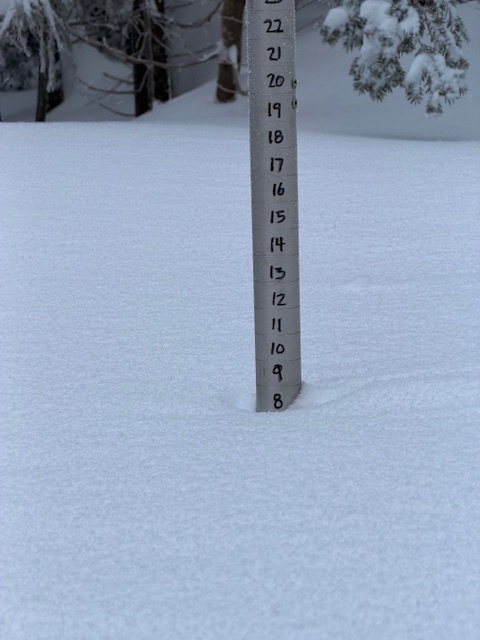
Healthy 8” (8.5) on the mountain.
-
Time for Upton to toss out a WSW. Expect it by 3-4pm.
-
Way more mixing. Can't use the snow maps
-
-

Snow Potential Dec 26-27
WestBabylonWeather replied to WeatherGeek2025's topic in New York City Metro
Starting at the Bronx and westchester border is upstate -

26th-27th event, coming at us like a wounded duck.
Kitz Craver replied to Go Kart Mozart's topic in New England
Right, we can always find a way to melt it down here, lol. Have to enjoy what we get when we get it. -

Central PA Winter 25/26 Discussion and Obs
Blizzard of 93 replied to MAG5035's topic in Upstate New York/Pennsylvania
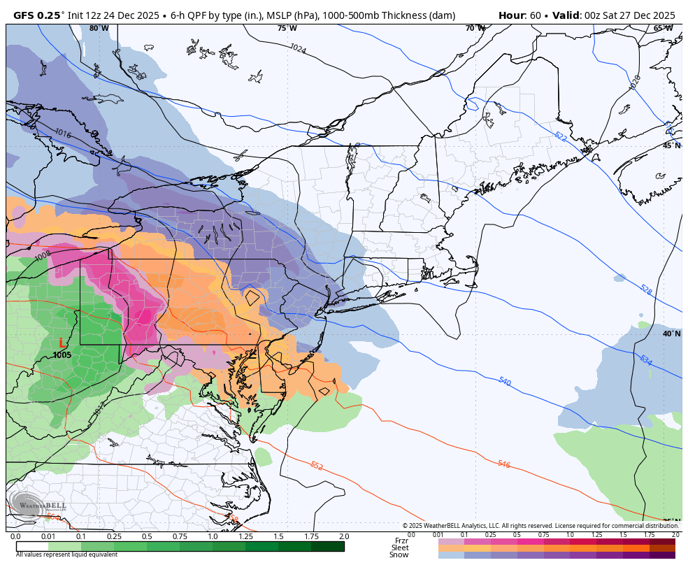
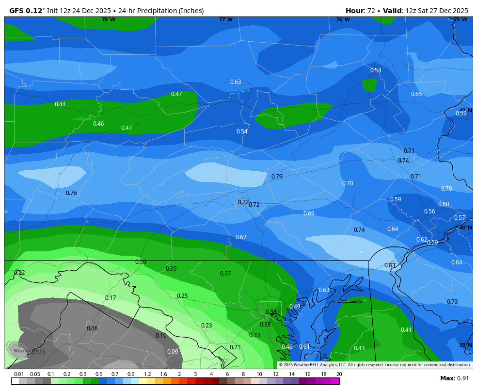
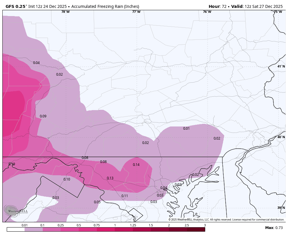
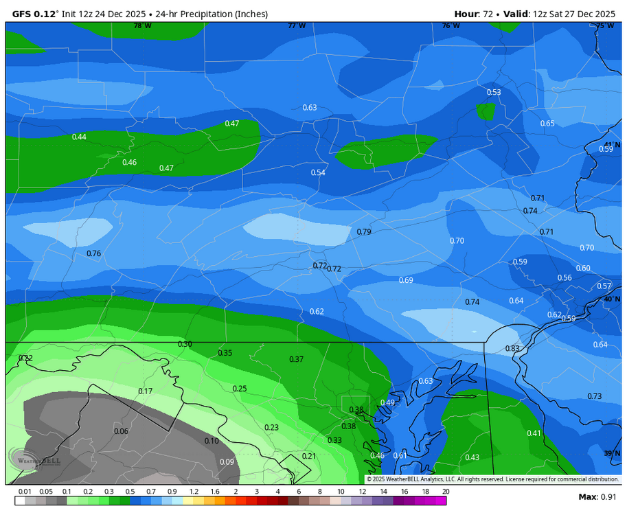
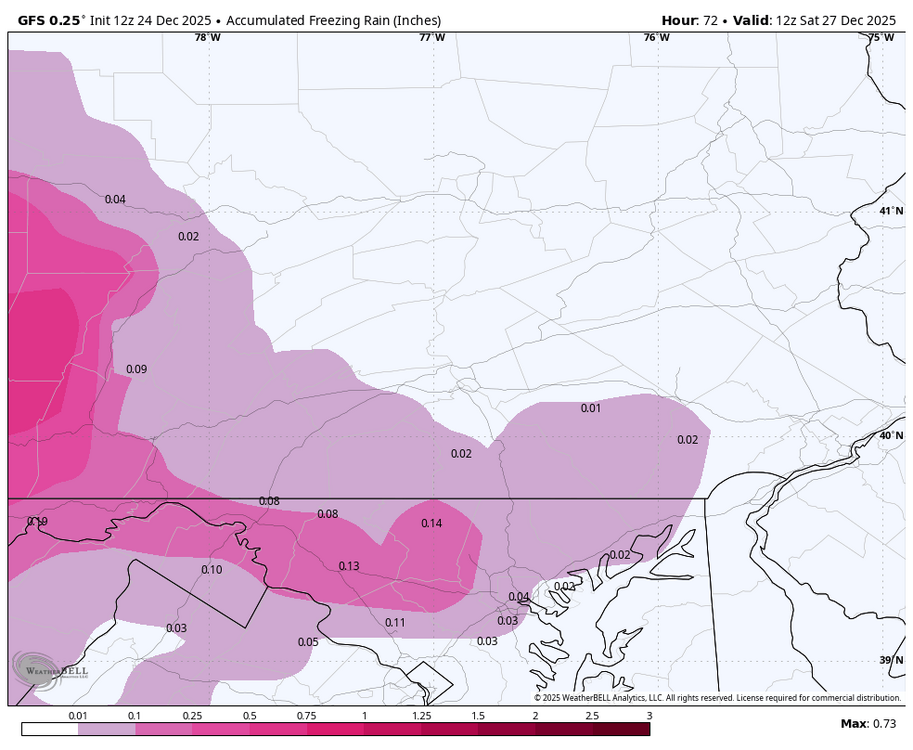
12z GFS is bringing .50 to .75 of precip into the cold dome. Hopefully heavy rates at the start can put down a little snow before the warming aloft kicks in, but it that amount of sleet would be impressive.
-
It does seem the SER is worse now and the 50/50 region trofing is not there as much. Here are 2 setups from the 80s which nowadays I would bet result in much more massive SERs than they did back then. Notice in both cases the low heights in the NW ATL, now it seems that feature is there less. https://www.meteo.psu.edu/ewall/NARR/1989/us0205.php https://www.meteo.psu.edu/ewall/NARR/1985/us0204.php
-
Everything north of Spuyten Duyvil is upstate, right?
-
CMC looks good! Similar to GFS
-
It's funny you mention that because they used to be really adherent to their naming criteria for mot years, but ever since last year, they let some storms slide without naming them lol. Usually, their criteria is 2 million people or more would have to be under a winter storm warning. But last two storms had well over that amount and they didn't do it, so maybe they changed their criteria?
-
Central PA Winter 25/26 Discussion and Obs
Blizzard of 93 replied to MAG5035's topic in Upstate New York/Pennsylvania
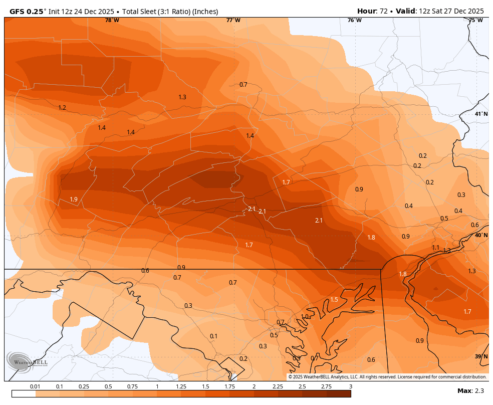
For those of us team heavy sleet, the 12z GFS delivers around 2 inches of sleet in the LSV on Friday with minimal freezing rain this run.
-
Give me any model but RRFS please
-

White Christmas Miracle? December 23-24th
DavisStraight replied to Baroclinic Zone's topic in New England
Still light snow here, not really adding up, ended up with a tad over 3 inches of wet, heavy snow. -
Did TWC name this yet?
-
Hazardous Weather Outlook National Weather Service New York NY 1020 AM EST Wed Dec 24 2025 CTZ005>012-NJZ002-004-006-103>108-NYZ067>075-078>081-176>179-251530- Northern Fairfield-Northern New Haven-Northern Middlesex- Northern New London-Southern Fairfield-Southern New Haven- Southern Middlesex-Southern New London-Western Passaic- Eastern Passaic-Hudson-Western Bergen-Eastern Bergen-Western Essex- Eastern Essex-Western Union-Eastern Union-Orange-Putnam-Rockland- Northern Westchester-Southern Westchester-New York (Manhattan)-Bronx- Richmond (Staten Island)-Kings (Brooklyn)-Northwest Suffolk- Northeast Suffolk-Southwest Suffolk-Southeast Suffolk- Northern Queens-Northern Nassau-Southern Queens-Southern Nassau- 1020 AM EST Wed Dec 24 2025 This Hazardous Weather Outlook is for southern Connecticut, northeast New Jersey and southeast New York. .DAY ONE...Today and tonight. Hazardous weather is not expected at this time. .DAYS TWO THROUGH SEVEN...Thursday through Tuesday. A winter system will approach the region Friday afternoon through Saturday morning, with the potential for an accumulating, plowable snow increasing.
-

White Christmas Miracle? December 23-24th
amarshall replied to Baroclinic Zone's topic in New England
banging here right now. Windy and white -
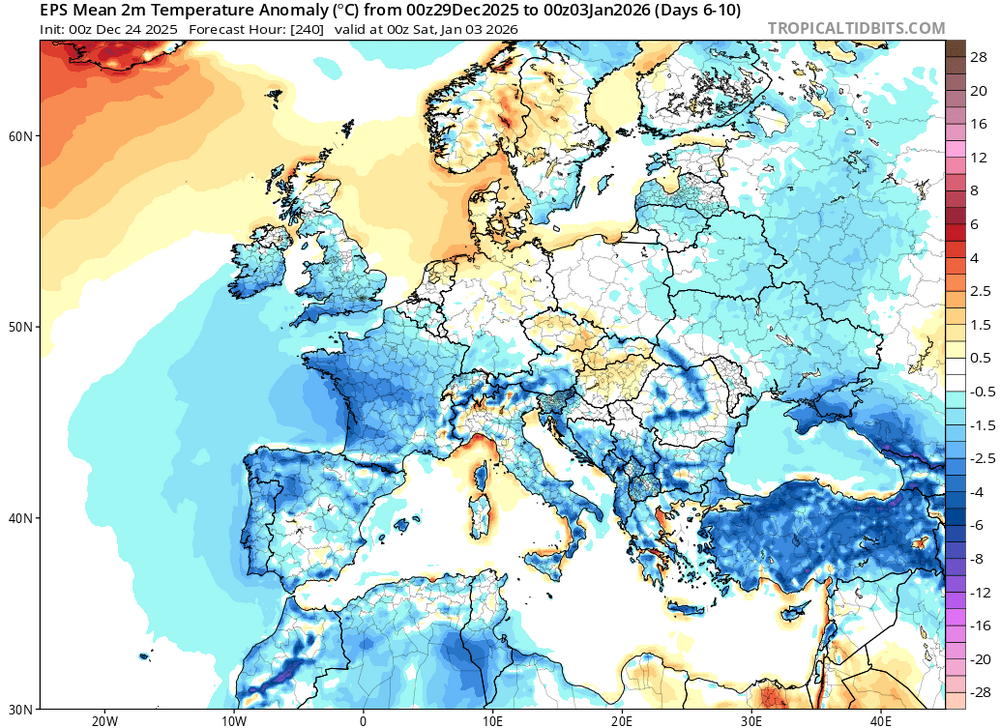
So far, it's been a warm winter, but a colder pattern is forecast to develop.

-

White Christmas Miracle? December 23-24th
TheMainer replied to Baroclinic Zone's topic in New England
Almost 8.5 inches at the lake, we snuck over 6 inches as it's still -sn, best guess with compaction about 6.5 in the valley here.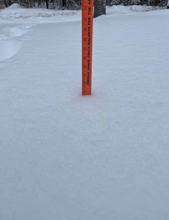
-

Boxing Night Snow/Sleet/Ice Dec 26-27 Storm Thread/Obs.
Mikeymac5306 replied to Mikeymac5306's topic in Philadelphia Region
Understood. I don't think anyone was looking for a monster storm from this. My point is there's more to it than just snow which puts another level on it. To me, Ice is way worse than snow. -

Boxing Night Snow/Sleet/Ice Dec 26-27 Storm Thread/Obs.
Birds~69 replied to Mikeymac5306's topic in Philadelphia Region
Yes it does. I remember asking a MET that question. Do you agree or should it have its own category? -
But 6-7 is the predicted amount for NB so it seems like a much higher probability for the higher end
-

White Christmas Miracle? December 23-24th
WxWatcher007 replied to Baroclinic Zone's topic in New England
Upslope ftw. Still snowing here.