All Activity
- Past hour
-
Anyone else here into working out? Me and my fiance hit the gym 6 days a week and take what we eat seriously. Gym couple goals.

-

Central PA Spring 2026 Discussion/Obs Thread
canderson replied to Voyager's topic in Upstate New York/Pennsylvania
I moved to PA in 2006. I cannot recall a more favorable setup here than tomorrow for a QLCS packing 70-90 mph winds, hail and perhaps a tornado closer to the MD border. -

3/16/26 Severe Weather Event Thread (Day 2 MOD Risk)
Maestrobjwa replied to Kmlwx's topic in Mid Atlantic
Yeah I mean it's literally his name -
Not really. He’s basically saying still a lot of moving parts and not to trust anyone solution. Which is playing out in real time. Note the model shifts just in the last 12 hours. Which is why I complemented LOT. Issued a conservative call but with some flexibility if short term trends change. Looks like 2-4 still in play here in Dupage. I’ll take it and than gladly close the book.
-
Shouldn’t high risk, be high risk? Haha
-
Idk about using global models at short range, but interesting dual maxima of snow on GEFS in NW IL and NE IL. Who knows what happens.
-

Pittsburgh/Western PA WINTER ‘25/‘26
TheClimateChanger replied to Burghblizz's topic in Upstate New York/Pennsylvania
Up to 66F at PIT. If we can hit 70F, that would be the fifth 70+ day of the year already, which would match 2025, 2000, 1946 & 1876 for most on record. Little bit of weather trivia there. -
I nominate @high risk to replace Ellinwood
-
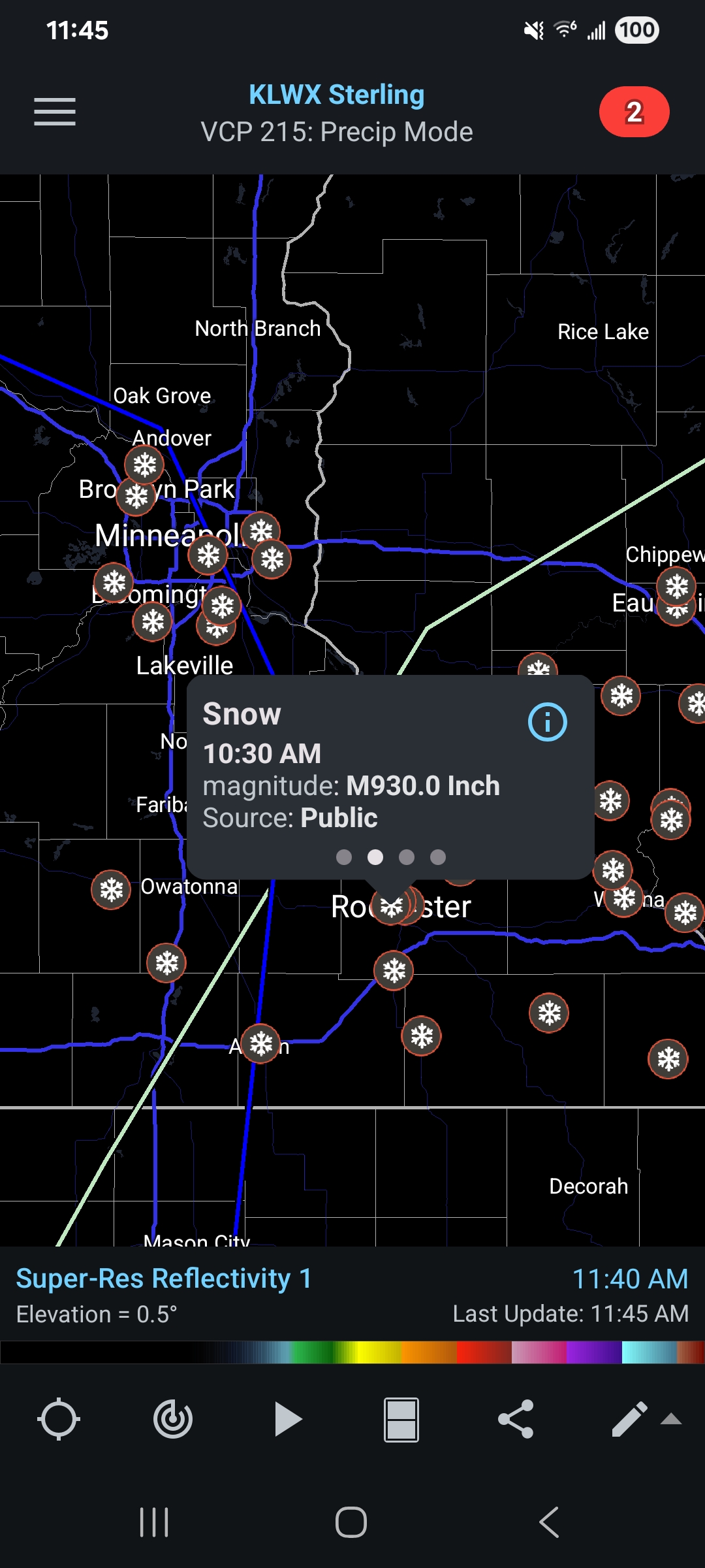
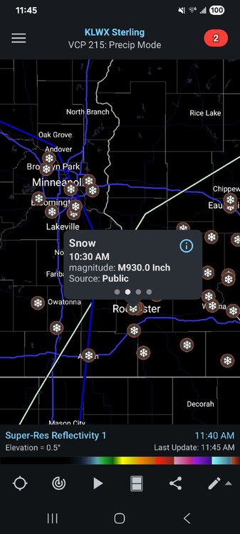
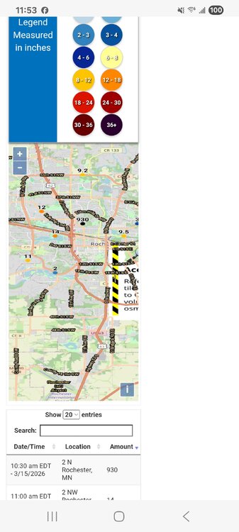
Measured 6”. What a complete joke after what the models showed for so long. I swear the north metro has a weather curse. .
-

3/16/26 Severe Weather Event Thread (Day 2 MOD Risk)
WxWatcher007 replied to Kmlwx's topic in Mid Atlantic
A representative from every preceding rung must be on board to go to the next step. I know Ian and Ellinwood aren’t around as much now so it may be time to update the system—just like the SPC. It’s just worked so beautifully for the last what, decade? -
Eskimo Joe has been in... so I think we are at the top rung lol
-
So mysterious
-

Central PA Spring 2026 Discussion/Obs Thread
mahantango#1 replied to Voyager's topic in Upstate New York/Pennsylvania
Seems quite unusual that CTP is strongly on board for this event. They are usually pretty conservative. -
yep.
-
Central PA Spring 2026 Discussion/Obs Thread
mahantango#1 replied to Voyager's topic in Upstate New York/Pennsylvania
Tomorrow I'd just like to have a good thunderstorm consisting of good thunder and continuous lightning without wind over 25mph. But I guess we'll see what tomorrow brings. -
This is your moment
-
1) Must have used some laser device to measure 2) The device must be slanted at a 170° angle
-
3/16/26 Severe Weather Event Thread (Day 2 MOD Risk)
WxWatcher007 replied to Kmlwx's topic in Mid Atlantic
Where’s @Ellinwood on this setup?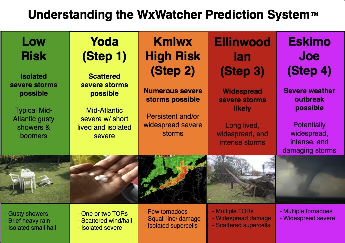
-

3/16/26 Severe Weather Event Thread (Day 2 MOD Risk)
Eskimo Joe replied to Kmlwx's topic in Mid Atlantic
Good trends if you want legit severe here tomorrow. -
Well i guess we have a new weenie record in WI It's also on here for now - https://www.weather.gov/source/crh/snowmap.html?sid=mpx

-
Temp holding steady at 32F here. A light glaze on above ground surfaces and had some pea size hail earlier. Watching reports out to the west, waiting for switchover later this afternoon.
-

3/16/26 Severe Weather Event Thread (Day 2 MOD Risk)
snowfan replied to Kmlwx's topic in Mid Atlantic
Impressive surface cold push right on the heels of the front.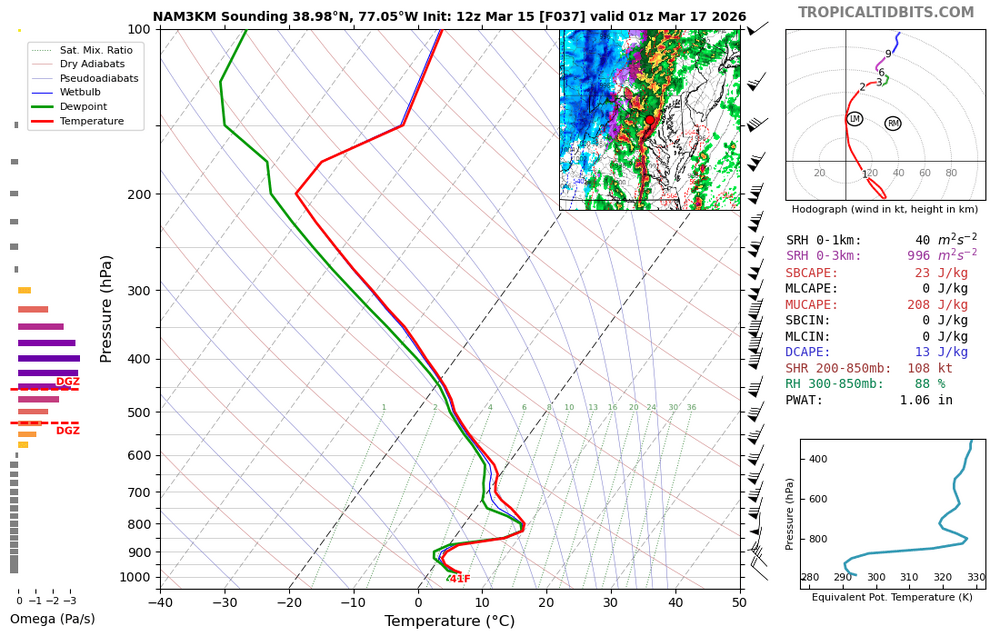
-
Made it on here for now too lol https://www.weather.gov/source/crh/snowmap.html?sid=mpx
-
3/16/26 Severe Weather Event Thread (Day 2 MOD Risk)
snowfan replied to Kmlwx's topic in Mid Atlantic
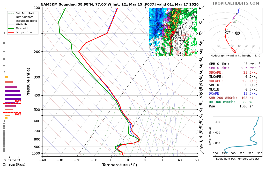
3k NAM has some cells running sw to ne well ahead of the front tomorrow after lunch in the warm sector.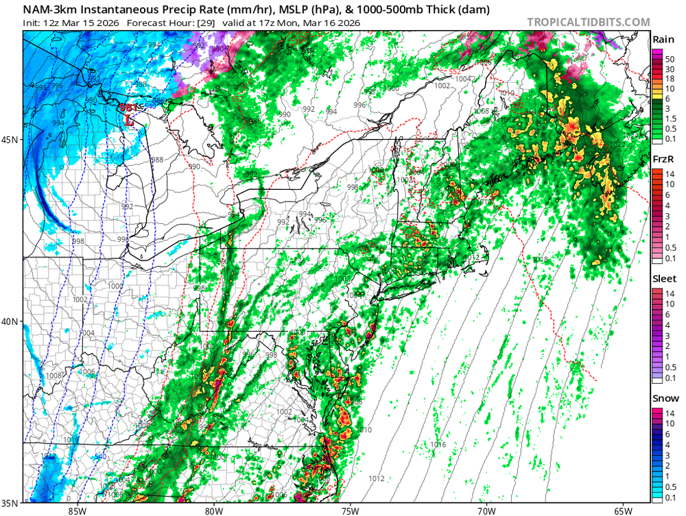
-

2025-2026 Fall/Winter Mountain Thread
Maggie Valley Steve replied to Buckethead's topic in Southeastern States
Looking like the 12Z GFS agrees with the 3km NAM regarding the snowfall possibility.