All Activity
- Past hour
-

The “I bring the mojo” Jan 30-Feb 1 potential winter storm
Orange county replied to lilj4425's topic in Southeastern States
Well they have been consistent today -

The “I bring the mojo” Jan 30-Feb 1 potential winter storm
olafminesaw replied to lilj4425's topic in Southeastern States
Lol, lock it in!
-
No, because the cold air is here with snow on the ground...acts like a warm blanket for them
-

The “I bring the mojo” Jan 30-Feb 1 potential winter storm
Ravens94 replied to lilj4425's topic in Southeastern States
.thumb.png.fe42a082e313e6ea3ac3cc1b364fe173.png)
-
It's just getting more into a better range for it. Also, keep in mind, most models tend to actually underestimate QPF.
-

The “I bring the mojo” Jan 30-Feb 1 potential winter storm
PackGrad05 replied to lilj4425's topic in Southeastern States
Mike Maze put out a PM update. He said snow total probabilities are dropping off on the Euro. Two bullseyes setting up. -
Johnson City is 93 percent for over 4 and about 80 percent for oved 6.
-

1-30/2-1-26 Arctic Blast, ULL Snow Event
Hurricaneguy replied to John1122's topic in Tennessee Valley
Hate RGEM is trending drier each run. One trend red flag for me on the difference between snow and a solid snow. -
The “I bring the mojo” Jan 30-Feb 1 potential winter storm
UpstateSCBud replied to lilj4425's topic in Southeastern States
WYFF snow totals looking very similar to WeatherNext 2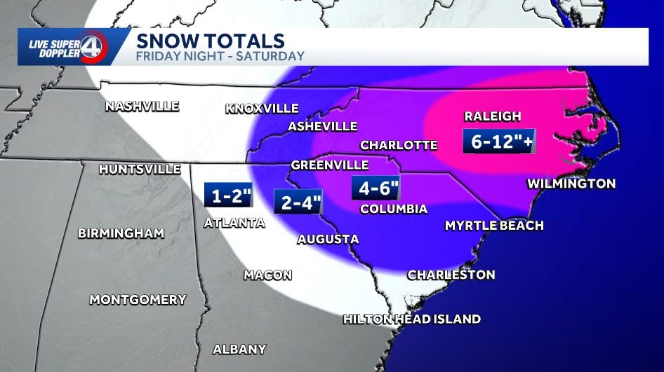
-

Central PA Winter 25/26 Discussion and Obs
canderson replied to MAG5035's topic in Upstate New York/Pennsylvania
I’m really ready for the 33 degree day next Tuesday. -

Mid-Long Range Discussion 2026
WinstonSalemArlington replied to BooneWX's topic in Southeastern States
Still cold deep into February -
18z missed RGEM
-
Newest NWS graphics dramatically increased snow accumulation percentages for my area. I was 22 percent for more than 2 inches last package. I'm now near 70 percent. I had a 10 percent chance of 4 inches or more, now that's 50 percent.
- 406 replies
-
- 1
-

-
- extreme cold
- snow
- (and 1 more)
-
First time I’ve left my place since Saturday due to a cold and busy work schedule combo. Looks more like it snowed than sleet..so that’s fun. Roads are in pretty decent shape. And when the sun is out it’s still cold af, but a lot more tolerable.
-

The “I bring the mojo” Jan 30-Feb 1 potential winter storm
BlizzardNole replied to lilj4425's topic in Southeastern States
Your area got nailed last February too, congrats! How rare are 12-inch snowfalls in back-to-back years there? We've gone 10 years now without one in the DC/Balt region. -
The “I bring the mojo” Jan 30-Feb 1 potential winter storm
Ravens94 replied to lilj4425's topic in Southeastern States
Just a coastal crusher on the icon.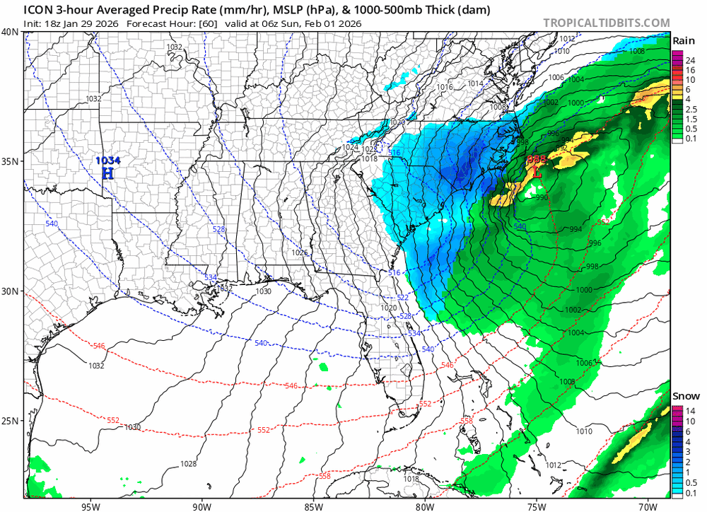
-

Richmond Metro/Hampton Roads Area Discussion
CentralVaGirl replied to RIC Airport's topic in Mid Atlantic
Sean Sublette was laid off by the paper quite a while ago. He has a consulting business now. He also does a Substack post and sends weather emails a couple of times a week. He did explore running for office but dropped out of a crowded field. I like his email and posts. -

Possible coastal storm centered on Feb 1 2026.
Typhoon Tip replied to Typhoon Tip's topic in New England
Ah... there's multiple reasons why this thing's behaving the way it is in the guidance - not one silver bullet. Having a S/W cresting the western ridge, doing so at a fast rate of speed is giving this thing on the east coast an non-linear negative interference ... ( transitive destructive - ). Some of this is going on, but not the whole story. What Brian was discussing certainly contributes, too. Then there's the convection. It occurs to me that there is an anomalously intense B-C axis in that vicinity down there. There really has to be, when there's been days of -3 SD air mass near-by a hotter than normal SW Atlantic OHE for the past 10 years. Ha. I mean Jesus... the convective potential is so extreme - if that metric were kept track of, it's probably historically volatile. Really, the expression "too much of a good thing" keeps hittin' at me. You can't exceed a threshold of potential in convection. Have you ever heard of the "K Index"? It's number that describes the general convective response once trigger has taken place. For example... in the Plains, a low K index with a very high CAPE and CIN collapse produces low counts of CB but huge super cells. If the K Index is high... the whole region erupts all at once and kills the organized super cells... etc. Something similar - this is where it's supposition but the more I look at this I suspect it to be so ... - is taking place where there is a high potential for convective response, with no inhibition... The whole region is igniting pretty far ahead of the trough... and there is so much potential due to the extremes of air mass over hot water ( relatively speaking) that the convective processing is blowing a hole in the troposphere and creating a new closed 500 surface out ahead of the real tough. That's why we are seeing this shit.. If you follow this 84 hour NAM chart back in time, you can see how the convection is evolving it's own S/W presence and then taking over... It's like a Miller B at 500 mb level.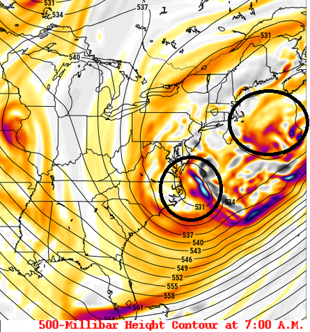
-

Possible coastal storm centered on Feb 1 2026.
Lava Rock replied to Typhoon Tip's topic in New England
on to Feb.... -

The “I bring the mojo” Jan 30-Feb 1 potential winter storm
wncsnow replied to lilj4425's topic in Southeastern States
Good old subsidence from being directly under the tallest mountain range east of the Mississippi.. -

Possible coastal storm centered on Feb 1 2026.
Great Snow 1717 replied to Typhoon Tip's topic in New England
Nearly 75 pages on this lol.... -
The RGEM backed down by about .2 on snowfall across the area. 4.4 in Knox at 12z was 4.2 at 18z.
-
How does the NBM go up for the Philly-NJ-NYC region after every 12Z model was a whiff (other than the SREFs)?
-

Pittsburgh/Western PA WINTER ‘25/‘26
EVLINC64 replied to Burghblizz's topic in Upstate New York/Pennsylvania
2 weeks out or so, don't want the Bullseye on us -
The “I bring the mojo” Jan 30-Feb 1 potential winter storm
Ravens94 replied to lilj4425's topic in Southeastern States
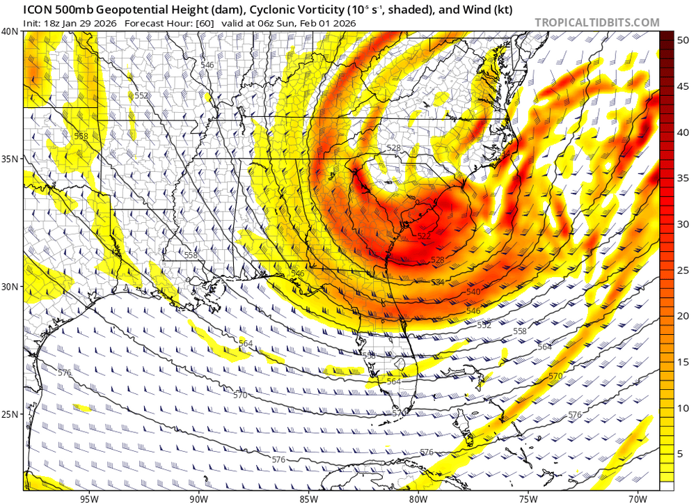
Icon is a hammer

.png.0e54a3c3b50b33c29328369b9cbdfa65.png)


