All Activity
- Past hour
-

2/22-23 "There's no way..." Storm Part 2
midatlanticweather replied to Maestrobjwa's topic in Mid Atlantic
@mill -

“Cory’s in NYC! Let’s HECS!” Feb. 22-24 Disco
78Blizzard replied to TheSnowman's topic in New England
Let's get real about one run of the GFS. Yesterday's 18z run had 2.16" qpf here for this storm only, then at 0z it had only 1.29", before going back up to 1.91" at 06z. Now it's back down to 1.55" at 18z. I'll bet it's back up significantly again at 0z. -
Hey how the heck are you! Still down in DC? Still taking pictures?
-

2/22-23 "There's no way..." Storm Part 2
SomeguyfromTakomaPark replied to Maestrobjwa's topic in Mid Atlantic
At this point I’m going with the euro/mesos. GFS sniffed it out yes but that doesn’t mean I trust it at this range. -
It wasn’t
-
Is the ridge in the west where we would want it?
-
Updated UKMET
-
I’ve been solid on 2-6” for MBY so far. Think I’ve seen enough to bump that to 3-7” but I’m still cautious for us. But I feel good about the floor. Seems most bust potential on the high end? Someone probably will get screwed. DCA is always the best odds.
-

“Cory’s in NYC! Let’s HECS!” Feb. 22-24 Disco
Prismshine Productions replied to TheSnowman's topic in New England
RAP cut back too Sent from my SM-S166V using Tapatalk -

“Cory’s in NYC! Let’s HECS!” Feb. 22-24 Disco
codfishsnowman replied to TheSnowman's topic in New England
Well I told my central Ct peeps it looked like a big deal but told them up here I wasn't convinced of more than a respectable snow storm unless we got lucky with banding. I feel not nearly as excited seeing the Icon and GFS cut back like that ...those aren't little moves for folks on the edge. In fact a few more of those and its a foot of windblown snow on the cape and islands Gfs and icon big sudden cutbacks, really hope that's a blip -
GFS⁉️
-
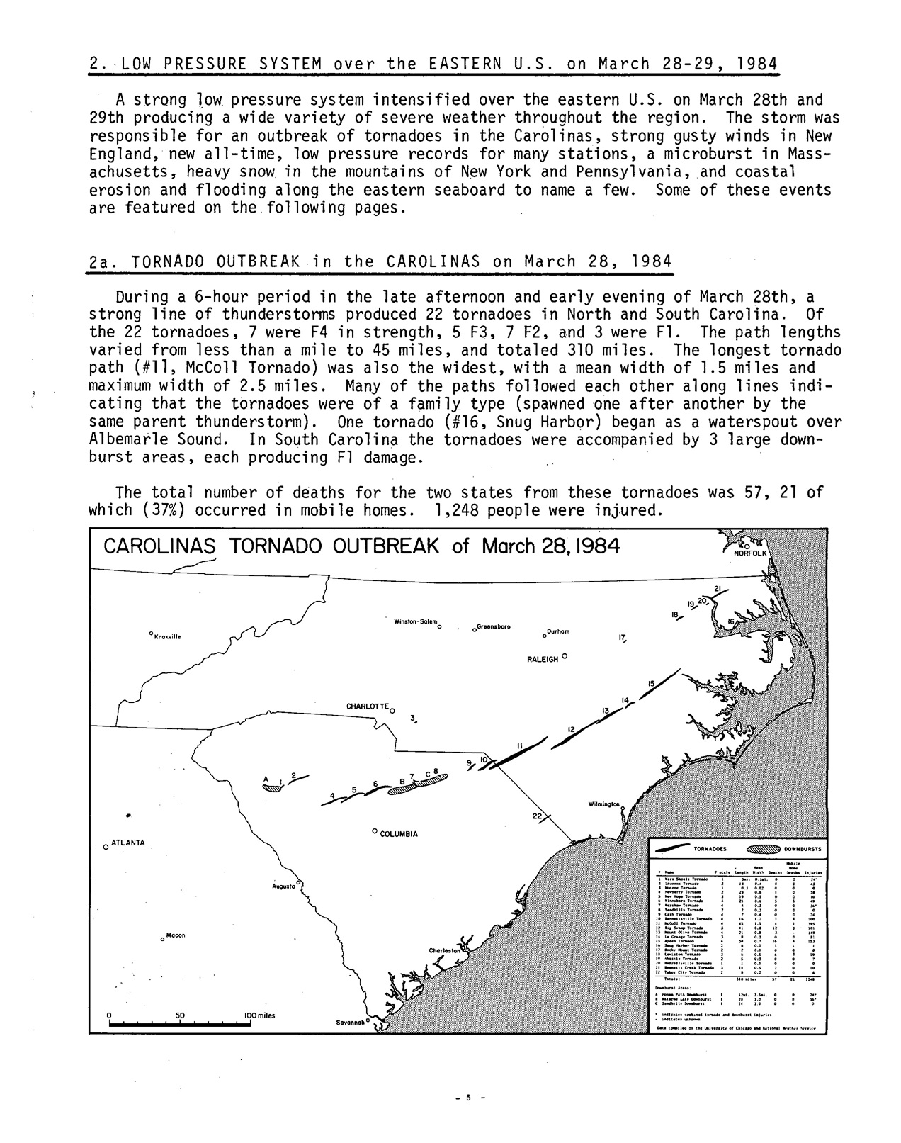
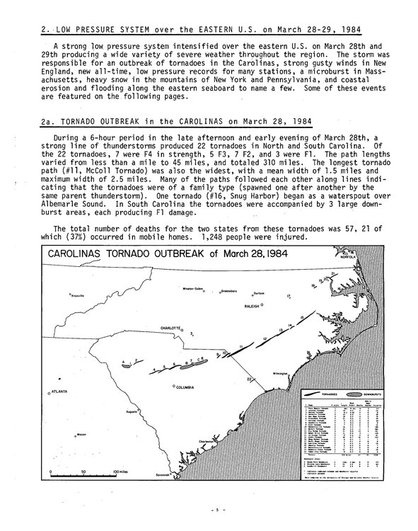
That was 3/27-29/1984. That storm across much of the South and East Coast was in a class by itself. 963 mb E of the Delmarva and G108mph at Blue Hill. Paste blizzard here w/ massive tree damage and power outages. Carolina tor outbreak its worst on record. One tor was 2.5 mi wide. A single supercell product 7 F4 tors, the record for most F4s from a single storm.
-
I think what's at issue here is A: How much precip falls B: How much of that preceip is frozen I've seen anywhere from 1 inch to 3.5 inches of precip over NYC.
-
At least you can actually USE your elevation now unlike the last 5-6 years!
-

“Cory’s in NYC! Let’s HECS!” Feb. 22-24 Disco
CoastalWx replied to TheSnowman's topic in New England
May have to lock 21z RAP -
2/22-23 "There's no way..." Storm Part 2
SomeguyfromTakomaPark replied to Maestrobjwa's topic in Mid Atlantic
lol that’s wild, I have no idea what to forecast for dc. -
GFS seemed like a step back. We’d really rely on the IVT. hopefully the other more western depictions of the field work out.
-
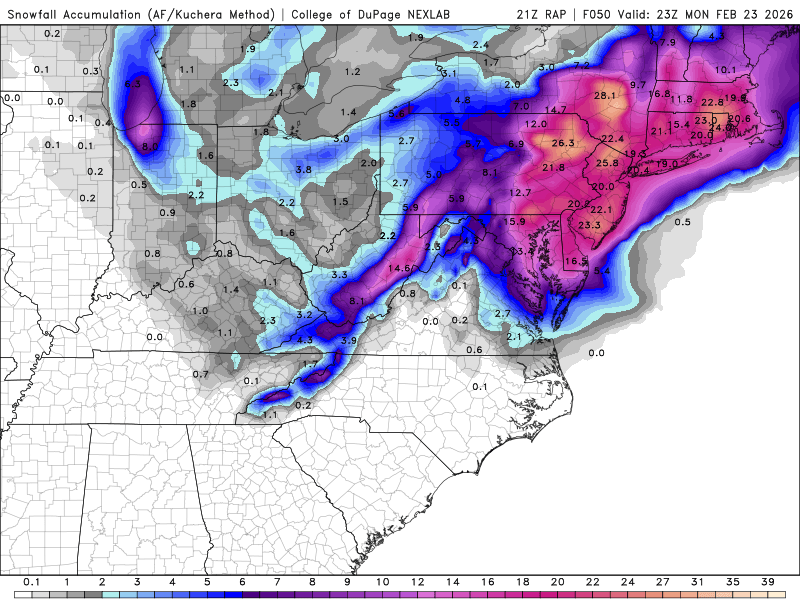
Rap....Now we're talking. Finally one of the models gets a 1'+ out this way.
-
Very true.
-
2/21 18z UKMET Total QPF 2/22-2/23-24 Snow 1:1
-

“Cory’s in NYC! Let’s HECS!” Feb. 22-24 Disco
MaineJayhawk replied to TheSnowman's topic in New England
With this system quickly spiraling into irrelevance, it’s time to focus on Wednesday and Friday -
Mammoth is 100 percent OPEN! Skiers are partaking of 6 foot deep fresh powder, and because of the frigid cold there, it is true pow, and they are gonna need SNORKELS! There's gonnabe tons of places hidden away in the glades of deep DEEP POW, snowboarders' delight! Who needs apres when you can ski super deep powder off piste?!!
-
Draw the shades.
-

“Cory’s in NYC! Let’s HECS!” Feb. 22-24 Disco
Typhoon Tip replied to TheSnowman's topic in New England
paranoid dopa addicts -
Latest RAP, kuchera is jucied