All Activity
- Past hour
-

Pittsburgh/Western PA WINTER ‘25/‘26
jwilson replied to Burghblizz's topic in Upstate New York/Pennsylvania
Not ready to buy into an idea of sustained winter return just yet. We might get intermittent cold shots, but on the ensembles it still looks quite brief, and even the long-range GFS/Euro have tempered the cold look for next weekend. A couple days of high 30s spread apart. EPS and GEPS are generally warmer outside the northern plains. GEFS shows a more matriculating cold into the east, but that's at the very end of the run, so the potential length is unknown. +AO and +NAO look persistent. -PNA, as well. MJO into Phase 5 is what I'd call "tempered" or neutral in March, but Phase 6 is straight warm. Magnitude dependent. Seems like a more balanced or oscillating pattern - no full torch or deep winter. Maybe later in the month things move definitively, either way. -
-

Outta gas and Outta Time: Early March Winter Storm finale
HighStakes replied to Ji's topic in Mid Atlantic
Has there ever been a more narrow band. Unreal! -
52.7 so far.
-

Outta gas and Outta Time: Early March Winter Storm finale
TSSN+ replied to Ji's topic in Mid Atlantic
Probably more accurate lol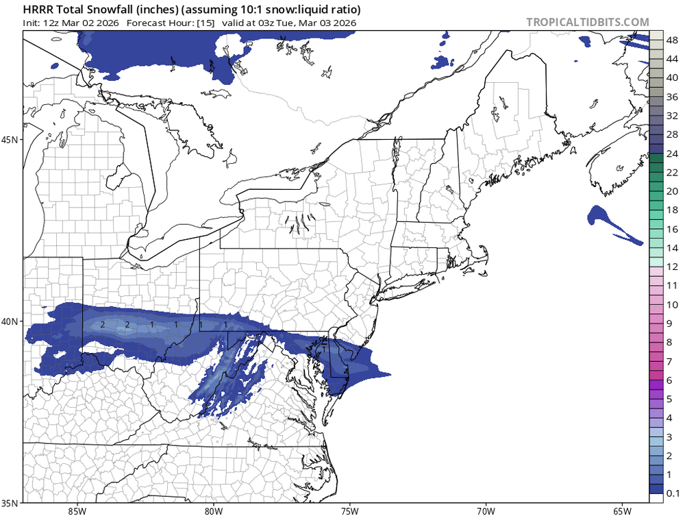
-
The Northern Hemisphere winter cold pool has really shrunk following the dramatic warming which occurred in 2015-2016 across the globe and North America. So while this was a great winter for us, it was the 2nd warmest across the CONUS. Past winters this cold and snowy in the East also had extensive cold further to our West with much colder CONUS rankings. Several years had coast to coast cold which was missing this winter. So in this much warmer world it was a challenge for places to have an all-time winter for both snow and cold. There was definitely a colder global temperature sweet spot from 1993-1994 to 2014-2015. This allowed for the all-time snowiest winter in PA during 1993-1994, our area in 1995-1996, DC to Philly in 2009-2010, Detroit and the Great Lakes in 2013-2014, and Boston in 2014-2015. None of these benchmarks were able to be approached this winter with the smaller footprint of the cold. The big question going forward is how long will it be before we see another locally cold and snowy winter near this magnitude since the last ones were over 11 years ago? Climatologist49 @climatologist49.bsky.social Follow December 2025 through February 2026 was the 2nd warmest winter on record for the Contiguous U.S. according to Prism climate data. The widespread record to near record warmth in the west easily outweighed the cool temps in the east. 11:39 AM · Mar 1, 2026
-
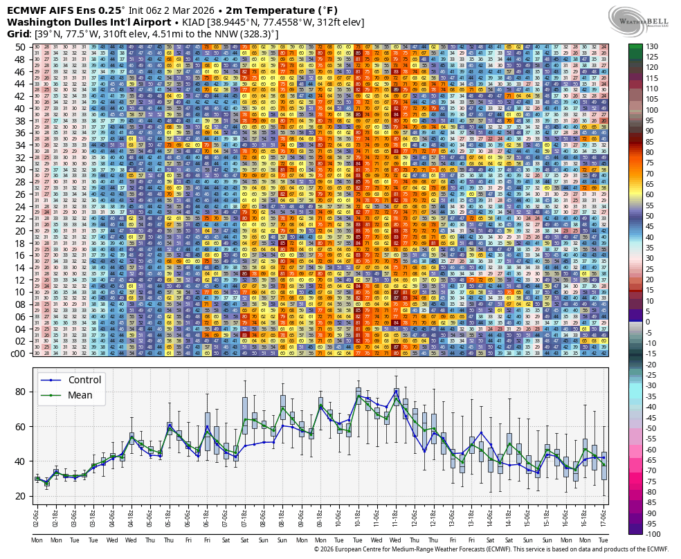
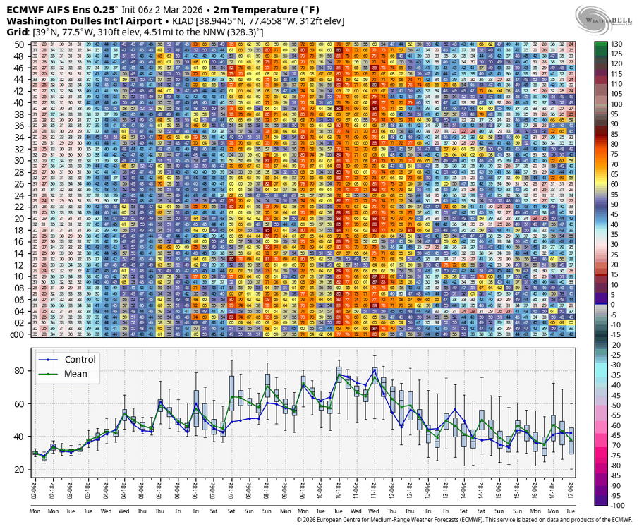
IAD and DCA records for 3/11 are 79°. Good chance that’s wiped out and it’s 9 days away.
-
Yeah... some definite warmth heading here. Not sure I get 70s (even 60s?) but a bunch of 50s and some rain. Ah well. Should make my road even more special. Frost heaves potholes will be epic
-

Outta gas and Outta Time: Early March Winter Storm finale
dailylurker replied to Ji's topic in Mid Atlantic
Anything left on the ground up there? I might head up there this afternoon after I do some work. -
been smelling something rank for a couple days now, getting ready to get my 38 and drizzle on
-
our march average is what 5, taking the early under
-
Man 2012 is close to knocking on our door. Too bad.
-
Snow missed just south last night. MLI now down -10.1" for the season.
-
-
In other words, typical Spring weather for the region...
-

Outta gas and Outta Time: Early March Winter Storm finale
clskinsfan replied to Ji's topic in Mid Atlantic
26/13. This will be my second biggest event of the year if it pans out. -

Outta gas and Outta Time: Early March Winter Storm finale
Chris78 replied to Ji's topic in Mid Atlantic
21 up in the Catoctins this morning. Whatever falls with definitely stick to everything -
Yup timing is my concern with the MJO. Hitting 8 on the 20th is a bit late and everything would have to line up for snowfall. That being said it has to be monitored. If the forecast is off by a few days and its earlier we can increase snowfall chances.
-
The trough set up too far east for east St. Louis this year. If the trough was a little further west our snowfall COULD have been MUCH higher.
-
It could be the case - out of curiosity what drove the persistent-ao this year? Looks like we do hit 8 once again but will see if its early enough.
-
It is kind of funny that while we had a cold winter, the vast majority of the country saw one of the warmest winters on record. Florida, even with the cold spell, saw their 2nd warmest winter, DJF period. Looking at the developing pattern, I do think spring will come in very quickly. I do think ski season will end up ending earlier than normal throughout the region. I also think this will be one of the warmer summers. Enjoy the snow cover while you can because it will be brown and muddy after it melts.
-
It’s starting to look likely that this SSW/split doesn’t downwell and couple with the troposphere later this month. This is following the theme we’ve seen recently where there is a disconnect between the stratosphere and troposphere and they don’t end up coupling @donsutherland1 @bluewave
-
Those big Canadian highs will keep popping but if you’re south of the boundary with zonal flow — oh well. West to east the CP airmass goes without doing much more than grazing your hood with one cold night and morning.
-
Fruit trees will be blooming. Hopefully not wiped out by freezes down the road.