All Activity
- Past hour
-
We were in Paris and then Switzerland a few weeks ago. Everyone spoke a bit of English everywhere we went. We did not rent a car at all and relied on public transportation exclusively. My advice would be to look into the Swiss Travel Pass and then download the SBB app which will give you all of the public transportation schedules. Once you get the hang of it it is extremely easy to get around. Happy to answer any specific questions as well.
-
Where is the best place to check how much rain a specific area received last night?
-
What the fuck are you rambling about now .I love summer and everything that comes with i. Don't psycho analyze me when its you who should be on the couch. The majority of time I am on a beach in a pool or walking down the street and swimming in the lake..This cold ruins my fishing. Only good thing is cutting trees and yard work is more invigorating. You need another outlet besides Frisbee golf. When all models were showing this colder solution and pattern change I posted what the weeklies also were showing. No one wants that shit Tip. So do me a favor and go find someone else for your analysis.
-
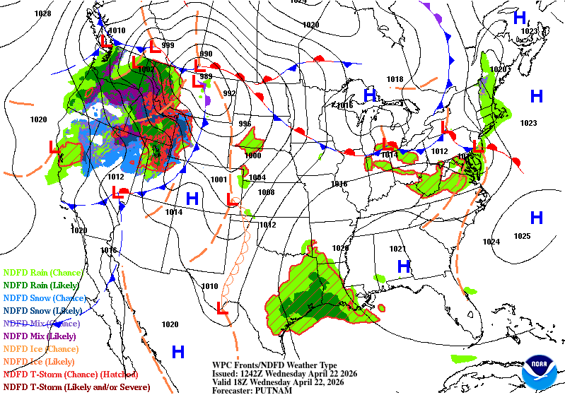
The weekend is now completely dry on 12z GFS. Sat into Sunday has a 90% chance of rain here per NWS point click
-
Yeah @jaxjagman Tennessee overnight is one of the highest state proportions in the Union. @Runman292 I was gonna say that's just since I moved here, lol! But Jax is right. Living in East Tennessee reminds me of living in eastern Kansas. Things get rockin' in the western part of the state, sometimes middle. Then the leftovers roll through at night. Occasionally it does start east and we get tornadoes too. Otherwise just like I now drive southwest to North Alabama, I used to drive southwest toward Wichita. Which brings us to Monday. Still looks possible Mid-South. Euro has the ol' east crap-out. Fresh 12Z GFS keeps it going. A lower scenario option is always the classic midday MCS shut-down. We'll see.
-
I don't really see any drought conditions in Frederick right now...certainly nothing like 2 summers ago when we became the Great Basin. Now we're more like Lincoln, NE.
- Today
-
Looks like I should have put down the dimension and grub X last Sunday while we had the rn. Nothing of significance in sight.
-
Ha! didn't y'all just have this exact same conversation two weeks ago? I don't get the impression you're succeeding in influencing that particular poster.. lol. Umm he's not inclined to agree with you, much less even read further than 'not great' when it comes to whatever it is he's using to promote the avoidance of inevitable seasonal progression toward summer. hahaha. that goes on here a lot. Like no problem admitting summer; but don't admit to signs and process -
-
Radar shows rain, but doesn't look like any is reaching the ground at GMU.
-
A few hundredths
-

Central PA Spring 2026 Discussion/Obs Thread
WmsptWx replied to Voyager's topic in Upstate New York/Pennsylvania
I like to think that I am a fairly smart (ass) individual. Reading @Jns2183 makes me feel Oklahoma public school levels of dumb. -

2026-2027 El Nino
MarcmmKU replied to Stormchaserchuck1's topic in Weather Forecasting and Discussion
I'm assuming the strong + enso event will pretty much guarantee a ratter ski season? Iirc, for northern new england they've never had a strong snow season in a strongly positive enso state. -
0.5” would be great, I’m worried it will be 0.15”
-
They are not always great beyond week 2. March was supposed to be cold and stormy instead it was a dry torch. I can think of a bunch of winters where they advertised a switch to cold and stormy and it never happened. So who knows maybe they'll be right this time. There is blocking developing so would lean towards cooler/wetter
-
We keep in mind also that the ambient thermal gradient between the tropic of Cancer and 50 N is getting weaker and weaker. By June, it's usually getting to it's perennial nadir - with the exception of any jet meanders which do happen once in a while. By and large though that all means the long wave, wave lengths are shortened to the point where any would-be NE Pac positive anomaly doesn't teleconnect that same in late May through late August as it does in late Novie through Feb/March. Shorter wave lengths in fact can intuitively signal a SW Canadian negative, over top a Great Basin/SW conus capping ridge, setting up future Sonoran release events... Quit a different implication from -EPO/January
-
Nice bonus showers this am about .10. Not drought busters but lawn is dark green and thick right now after a lot of work in the late fall/ early spring.
-
Looks like a lot of clearing all the way to the Great Lakes, which is pretty unusual. I'm inspired by the potential for sunshine this afternoon.
-
I recall coming across something recently too (I forgot who it was) about the PV vortex and how it seemed to be much slower with its seasonal demise through the spring so far. It's like the hemisphere on our side of the globe is dying to get us into an early summer but the lower stratosphere/upper troposphere is still programed to be blocky. Maybe rooting for these early season anomalous warm spells isn't a good idea lol...I mean eventually the ridging in place responsible for that warmth has to get shunted east (unless its a scenario in which the ridge just totally breaks down) and what happens when that ridging shunts east? You are building those positive heights into Greenland and it's hello block. With this we've fed the Arctic domain what it needs to become manifested in what it wants to do and the result is...weeks of hell. One thing that makes me really nervous going into May is the signal for some stout ridging to develop across the north Pacific and into the Gulf of Alaska. Eventually these teleconnections should begin to break down and their influence subside, but this opens the door to get omega block like moving into May.
-
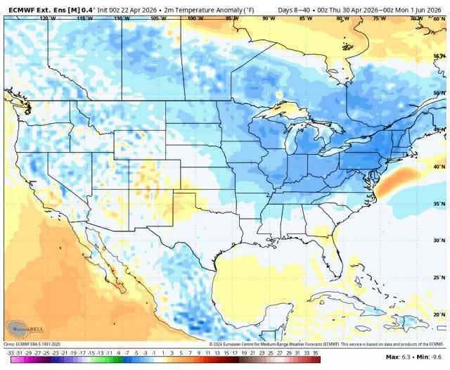
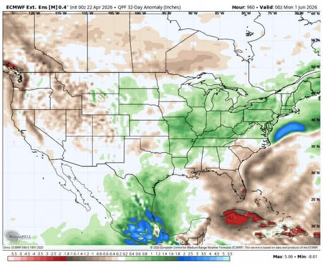
Weeklies
- 782 replies
-
- 1
-

-
- april showers bring may..
- rain
- (and 2 more)
-
Weeklies


-
40s and 50 down here for my sons baptism
-
April 22 1874: Unseasonably cold air moves into Minnesota. The low is 23 degrees at the Twin Cities. For Wednesday, April 22, 2026 1883 - An outbreak of tornadoes from Louisiana to Kansas claimed the lives to 200 persons. One of the tornadoes destroyed the town of Beauregard MS. (David Ludlum) 1980 - A record April heat wave sent the mercury up to the 100 degree mark in Iowa. (The Weather Channel) 1987 - Fifteen cities in the southeastern U.S. reported new record high temperatures for the date. The afternoon high of 96 degrees at Pensacola FL established a record for the month of April. (The National Weather Summary) 1988 - Heavy snow fell over northern Nebraska, with 15 inches reported at Mullen. Heavy snow also blanketed the mountains of northern Arizona, with 16 inches reported at Munds Park. (The National Weather Summary) (Storm Data) 1989 - Twenty-seven cities in the central U.S. reported record high temperatures for the date. The high of 96 degrees at Omaha was an April record, and the high of 100 degrees at Lubbock TX equaled their record for April. Hill City KS and Liberal KS tied for honors as the hot spot in the nation with afternoon highs of 103 degrees. (The National Weather Summary) 1990 - Thunderstorms produced severe weather from the Southern and Central High Plains to northwest Florida during the afternoon and evening. Thunderstorms produced wind gusts to 67 mph at Gillette WY, hail two inches in diameter west of Roswell NM, and deluged Cheyenne OK with 8.68 inches of rain leaving some parts of the town under five feet of water. Temperatures reached the low 90s in the north central U.S. Chamberlain SD and Pickstown SD tied Presidio TX for honors as the hot spot in the nation with afternoon highs of 94 degrees. (The National Weather Summary) (Storm Data) 2011 - Lambert International Airport in St. Louis experiences extensive damage as it is hit by a group of tornados, blowing out windows in the main terminal and tearing the roof off Concourse C. Five people were taken to the hospital with minor injuries from shattered glass and flying debris.
-
Oh, completely agreed! ( full disclosure, I'm hoping for it). I don't wanna give Kevin any reason at all to start pimping drought fallacies in attempts to set up the dystopian d-drip doses all summer... meanwhile, my lawn stays green until mid august. Yeah, as far as the NAO handling... it's ( we know this -) obviously a stochastic index domain... but I sort of ignore the distractions of the individual model runs and just rely on a combination of 3 basics: the 5 day running mean of the synoptic structure; climatology; personal experience - as you mentioned, that -NAOs tend to blossom/lag after a period of usual early warmth - particularly when said warmth is over the eastern mid latitude continent. This latter need correlative proof and is personally anecdotal, but it is a late winter and spring phenomenon I have noted over many years. Just combining all that gunk... -NAO appears set up and well ?
-
An OK call. A little slow with frontal passage that went through yesterday. System will be moving through starting tomorrow.

-
Sorry man, I moved out of Prince Frederick and took the rain (and snow?) with me to the mountains. It really is happening, I knew it would. My old yard in PF is burning up. Driest month ever there since I had started keeping track.


