All Activity
- Past hour
-

Nov 28-30th Post Turkey Day Wintry Potential
Radtechwxman replied to Chicago Storm's topic in Lakes/Ohio Valley
18z euro continues the heartbreak here. Man I wish I was more north. Stupid waa -
.thumb.jpg.ad3a2e31d30aff035044689b311a0540.jpg)
Nov 28-30th Post Turkey Day Wintry Potential
nvck replied to Chicago Storm's topic in Lakes/Ohio Valley
18z euro has a slightly stronger low, and a rain/snow line similar (slightly north) to the 12z. still sketchy if ur a chicago poster -

Nov 28-30th Post Turkey Day Wintry Potential
ILSNOW replied to Chicago Storm's topic in Lakes/Ohio Valley
18z Euro looks good -
That absolutely ripped my soul out. Full blown Kali Mah heart ripped out. When the cape pounded I ripped into some Jack Daniels.
-
Haha I remember that!!
-

December 2025 regional war/obs/disco thread
DavisStraight replied to Torch Tiger's topic in New England
December 07 saw 20 inches wiped down to nothing on Christmas eve, that was a bummer. -
I’m really hoping my reports will be needed this winter!
-
Best was Patrick o'hearn downhill racer
-
Periods of rain are likely tonight into tomorrow morning. Tomorrow will be unseasonably mild with temperatures topping out in the upper 50s and lower 60s across the region. Colder air will rush into the region tomorrow night. The closing days of November will be much colder. There is potential for New York City's Central Park to experience its first freeze of 2025. The 1991-2020 normal first data is November 21. The 1961-1990 baseline was November 11. Last winter's first freeze occurred on November 30. The opening days of December will turn milder. However, colder conditions could begin to develop during the second half of that week and continue through the second week of December. Severe cold appears unlikely through at least the first 10 days of December. The ENSO Region 1+2 anomaly was -0.7°C and the Region 3.4 anomaly was -0.7°C for the week centered around November 12. For the past six weeks, the ENSO Region 1+2 anomaly has averaged -0.16°C and the ENSO Region 3.4 anomaly has averaged -0.65°C. La Niña conditions will likely continue through at least mid-winter. The SOI was +7.63 today. The preliminary Arctic Oscillation (AO) was -0.426 today. Based on sensitivity analysis applied to the latest guidance, there is an implied 90% probability that New York City will have a cooler than normal November (1991-2020 normal). November will likely finish with a mean temperature near 46.9° (1.1° below normal). Supplemental Information: The projected mean would be 0.8° below the 1981-2010 normal monthly value.
-
AI EURO would be a nice start to the season
-
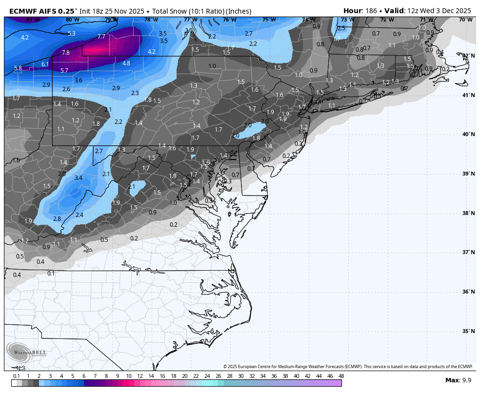
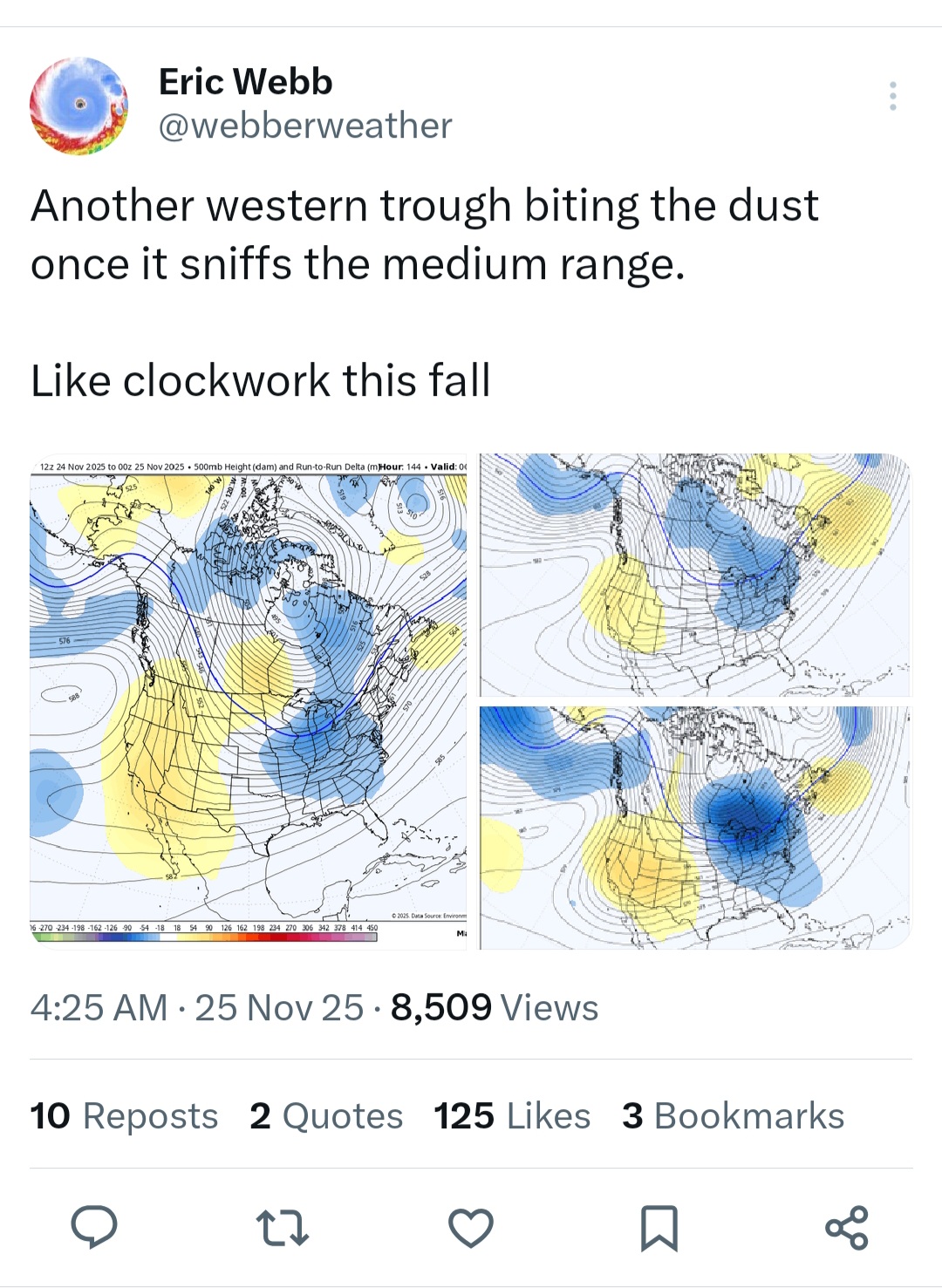
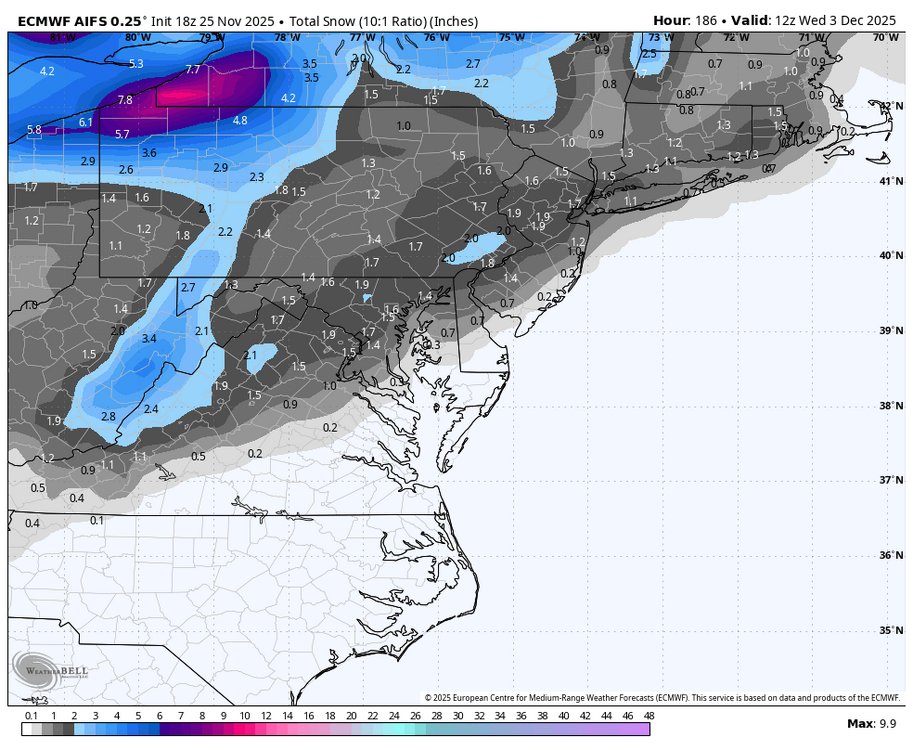
https://x.com/webberweather/status/1993264759794282993?t=BTUYDs0rjkTSzBtZFlACrg&s=19

-

Nov 28-30th Post Turkey Day Wintry Potential
ChiTownSnow replied to Chicago Storm's topic in Lakes/Ohio Valley
It's all about those ads. Joe bastardi style -
Nov 28-30th Post Turkey Day Wintry Potential
nvck replied to Chicago Storm's topic in Lakes/Ohio Valley
nothing but the best over there -
Nov 28-30th Post Turkey Day Wintry Potential
ChiTownSnow replied to Chicago Storm's topic in Lakes/Ohio Valley
I just figured it was an old map but when you look at the bottom right corner it's from today. -
Nov 28-30th Post Turkey Day Wintry Potential
nvck replied to Chicago Storm's topic in Lakes/Ohio Valley
think they might need to curve that arrow preeeeeeetty sharply in the opposite direction -
Nov 28-30th Post Turkey Day Wintry Potential
Radtechwxman replied to Chicago Storm's topic in Lakes/Ohio Valley
Yes please. Lol -
That’s more than five days out.
-
The last two GFS op runs are well east of the GEFS mean days 5 through 6 with the shortwave and SLP in the east. The GEFS mean shows precipitation primarily in the lower MS valley while the op GFS shows it along and off the east coast. Discounting the op runs for now though an eastward trend is noted in the other mid-range op models. The GEFS seem to be somewhat of a compromise between the 12z EPS and GEPS. The GEFS would put us right on the edge of both significant precipitation and marginal temperatures for wintry precipitation.
-
Nov 28-30th Post Turkey Day Wintry Potential
ChiTownSnow replied to Chicago Storm's topic in Lakes/Ohio Valley
Looking like a '90s map though -
Nov 28-30th Post Turkey Day Wintry Potential
ChiTownSnow replied to Chicago Storm's topic in Lakes/Ohio Valley
Not sure about this.AccuWeather..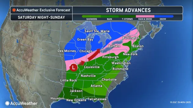
-

Nov 28-30th Post Turkey Day Wintry Potential
Baum replied to Chicago Storm's topic in Lakes/Ohio Valley
Hate to say it but an amped Madison special at the break of December ain’t necessarily a bad thing based on trends it seems for nearly a decade. We need to bury the south east suppressed program early this year. -

E PA/NJ/DE Autumn 2025 Obs/Discussion
simbasad2 replied to PhiEaglesfan712's topic in Philadelphia Region
Well... I'd be lying if I said I wasn't surprised. Not sure if I said this here or just thought it to myself, but I was convinced that the early December torch signal was gonna break the streak of every E US Ridge trending into a trough. And that we were going to be flooded with 60s to start the meteorological season. Todays 18z suite so far looks to be an extension of the trends already present on the 12z runs. We might even have our first accumulating snow event of the season. Per the 18z GFS, a relatively weak shortwave will round the base of the longwave/TPV lobe and a fast moving system could bring some light snowfall for someone in the Mid-Atlantic or Northeast early next week. Hopefully this isn't a repeat of 2024-25 where everything does a mega south trend to Antarctica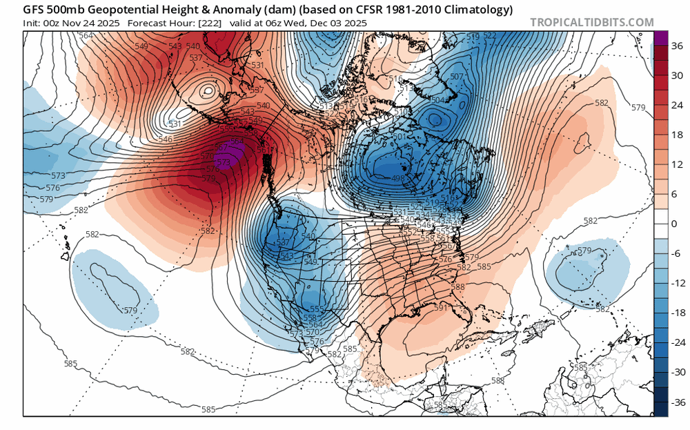
-
Let’s get that down to 26hrs then we talking.
-
Rippin' puddles here.
-
The Hayli Gubbi eruption: Reddit link I’ve been fairly preoccupied and trying to stay on top of all these volcanic developments and catch up in various threads here. Rest assured if anything really major happens on the volcanic front I’ll do a write up about it - though Hayli Gubbi erupting fits that bill as this doesn’t happen often (long dormant system suddenly waking up due to magma from a neighbor system), and this may not be fully over depending on what’s going on down below. I would also say there’s been some decent pulses of SO2 this year and last (Raung!) now into the stratosphere from all this activity. Not as much in total as say, El Chichon (and certainly nowhere close to Pinatubo), but enough to possibly have some effect. Was just reading about how cluster of VEI4’s may have had some impact in the 2009-2011 winters, which isn’t typical. Underscores that there’s a lot of interplay we don’t fully 100% understand, but I’ll always maintain volcanoes have a much bigger impact on climate than most realize. And we’re learning a lot of past historical climate disturbances were the result of multiple eruptions clustered together instead of just one, even Tambora had a massive precursor in 1808/9ish. But to be very clear anything from this year / last would be on the lowest end of impact, if at all. But still possibly something in total. Let’s see what happens going forward. Lot of systems showing unrest!

.thumb.JPG.418e8a9a2902ae687ec35ff4bc0e038e.JPG)