All Activity
- Past hour
-

2025-2026 ENSO
so_whats_happening replied to 40/70 Benchmark's topic in Weather Forecasting and Discussion
It is the same issue I had with folks thinking there were not 2013/14 style patterns showing up last season but since it did not snow nearly as much last year it was not a match. Not everything is exact and unfortunately you will not change the minds of folks, it is what it is. To redistribute that amount of warming you likely need consistent typhoon recurves and at that strong consistent synoptic activity coming off China/ Koreas/ Japan. Tropical activity has been very sluggish in the WPAC for some time and when we do have activity the main track has been almost due west at low latitudes with the stronger systems (maybe 1 or 2 systems in a season actually recurving) or 'home grown' systems (close to land formation). Honestly let's just see how it all plays out. -
 Does that mean Erin is visiting us
 -

Tropical Storm Erin - NOW AT 45 KTS @ 18Z!
WxWatcher007 replied to BarryStantonGBP's topic in Tropical Headquarters
Nothing really new from the NHC. The real interest will come with the 00z suite and whether this westward adjustment due to a less aggressive Canadian trough and rebuilding Atlantic ridge continues. -

Tropical Storm Erin - NOW AT 45 KTS @ 18Z!
BarryStantonGBP replied to BarryStantonGBP's topic in Tropical Headquarters
TNT45 KNHC 140238 TCDAT5 Tropical Storm Erin Discussion Number 11 NWS National Hurricane Center Miami FL AL052025 1100 PM AST Wed Aug 13 2025 Satellite images show that a solid area of convection remains near Erin, with low-cloud motions suggesting the center is on the northeastern side of the thunderstorm activity. Overall, there hasn't been a lot of change with the satellite presentation, and that is reflected in recent stable Dvorak and scatterometer values. The initial intensity is held at 45 kt for this advisory. The environment around Erin should remain marginally conducive during the next day or so, which will likely promote gradual strengthening. Thereafter, the storm is forecast to move across warmer waters, with potentially a decrease in shear. This evolution results in a period of potential rapid intensification late this week, and the official forecast reflects that possibility. While shear is generally forecast to increase over the weekend, this appears to be canceled out by large-scale divergence and water temperatures above 29C. Most models respond to this by showing a lower rate of intensification at that time. The new intensity forecast is adjusted upward somewhat from the previous forecast beyond 24 h based on the current guidance. There is increasing confidence on a large and powerful hurricane over the southwestern Atlantic Ocean this weekend. The initial motion is now 270/14 kt. There are no significant changes to the forecast track or steering. Erin should move westward overnight and then west-northwestward from Thursday through the weekend due to steering from the subtropical ridge. The ridge is forecast to break by early next week, resulting in a turn towards the northwest or north-northwest. The new forecast is basically an update of the previous forecast in the near term, and on the eastern side of the guidance envelope by day 5 between the consensus and the Google Deep Mind model. There is still a greater than normal uncertainty about what impacts Erin may bring to portions of the Bahamas, the east coast of the United States, and Bermuda in the long range. KEY MESSAGES: 1. Locally heavy rainfall, high surf and rip currents, and tropical-storm force winds could occur in portions of the northern Leeward Islands, the Virgin Islands, and Puerto Rico this weekend as the core of Erin passes north of those islands. Interests in these areas should continue to monitor the progress of Erin. 2. While there is still uncertainty in what impacts might occur in portions of the Bahamas, the east coast of the United States, and Bermuda next week, the risk of dangerous surf and rip currents across the western Atlantic basin next week is increasing. As we approach the climatological peak of the hurricane season, this is an opportune time to ensure your preparedness plans are in place. FORECAST POSITIONS AND MAX WINDS INIT 14/0300Z 16.3N 46.6W 45 KT 50 MPH 12H 14/1200Z 16.5N 48.8W 50 KT 60 MPH 24H 15/0000Z 17.2N 51.8W 55 KT 65 MPH 36H 15/1200Z 18.0N 54.9W 70 KT 80 MPH 48H 16/0000Z 18.9N 57.8W 85 KT 100 MPH 60H 16/1200Z 19.8N 60.6W 95 KT 110 MPH 72H 17/0000Z 20.6N 62.9W 100 KT 115 MPH 96H 18/0000Z 22.8N 66.6W 105 KT 120 MPH 120H 19/0000Z 25.5N 68.5W 110 KT 125 MPH $$ Forecaster Patel -
Good Lord please. No more Westward trends! "Right when you think your out, they suck you right back in."
-
Had a few rumbles this evening but Sahara conditions continue.
- Today
-
Nothing measurable in Maytown. Disappointing.
-
 i think anvil rain helped rather than hurt this time. ewr wet bulbed to a 75 degree dewpoint right before the storm hit
 -
Anyone want my .01 I got today.
-
shift west at 0z with the hurricane models.. I mentioned that a couple days ago. we pray
-
Tropical Storm Erin - NOW AT 45 KTS @ 18Z!
WxWatcher007 replied to BarryStantonGBP's topic in Tropical Headquarters
Among the consensus models, it has been quite a trend -

Tropical Storm Erin - NOW AT 45 KTS @ 18Z!
wthrmn654 replied to BarryStantonGBP's topic in Tropical Headquarters
00z tropical models look west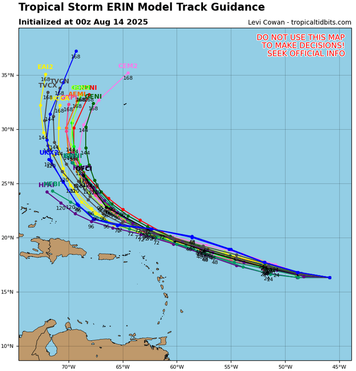
-
0.01" for the day. Driving around a little this evening was rainier, but just shows how spotty it was.
-
I did! .03”
-
 0.43” in Muttontown & 0.57” in Syosset
 -
 I was away in Provincetown for a week. It seems every time the models show the pattern changing to much cooler here they then back off of it some a run or two later. WX/PT
 -
1.17".
-
eps backed off on the cool down
.thumb.gif.d69385573bb1bf725b830bdb9e058491.gif)
-
 0.55” here, nice drink for the gardens. still 78 upstairs. Will be a hot night without AC
 -
Should be a hell of a wave maker if it gets to 74-75W
-
Still no actual tornadoes in New England this year? did I miss one?
-
5 rain drops and living in a tropical rain forest tonight.
-
 About 0.75-0.8” here. Need a lot more but a good start.
 -
Disappointment at BDL this afternoon, 89'd and the storms crapped out as they moved over us


.thumb.png.4150b06c63a21f61052e47a612bf1818.png)


.gif.17c8906f71157d38868cb2f8c3136c8b.gif)