All Activity
- Past hour
-
ICON was absolutely terrible at 00z, so anything's an improvement atp.
-
So far Looks like the ICON will be improved. Holding back the energy allowing the through axis to be displaced further west and ridging to amplify off the coast
-
I'm sorry, but it would be beyond hilarious to witness the emotional whiplash if all the 12z runs bring in some sort of epic shellac king for all. speaking it into existence....
-

E PA/NJ/DE Winter 2025-26 Obs/Discussion
The Iceman replied to LVblizzard's topic in Philadelphia Region
Ots but there are still a few big hitters. -
Looks like I’ll be visiting Terrapin Park in a week or so.
-

-
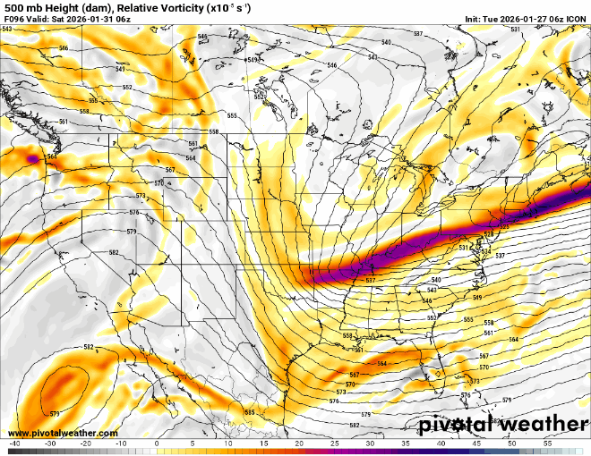
Icon looks vastly improved over 6z thru 78hrs but will it be enough?
-
Icon definitely further west with the western lobe of the northern trough at 72 vs 6z run fwiw.
-
Yep, I don’t see this as something that comes storming back and we’re sweating the mix/rain line but we’ll see. There is the kicker right on its heels and the NAO blocking so there’s only so far west it can really trend but 150-200 miles, sure.
-
just remember- even if they're doom and gloom, as currently modeled, we still have a shot at it.
-
On the Am Wx banner, create, topic, I think.
-
Northern Canada is a very data sparse region....
-

The “I bring the mojo” Jan 30-Feb 1 potential winter storm
PeeDeeWx replied to lilj4425's topic in Southeastern States
NAM did really well for my area last weekend. Better than the others. -
we need @psuhoffman to come sing us words of wisdom...let it be....
-

January 2026 Medium/Long Range Discussion
midatlanticweather replied to snowfan's topic in Mid Atlantic
^This board does it well! We are passionate about wins and losses! It feels personal when things miss us.. especially to the south!! -
Time to pull out Angels in the Outfield for this one!
-

January 24-26: Miracle or Mirage OBS Thread!
nw baltimore wx replied to Jebman's topic in Mid Atlantic
I did a core sample with the large CoCoRaHS tube and came up with 1.87” total. -
I like where this is at so far. Not far off from giving a significant snowfall for much of the region, though I'm excited being at the coast. Still plenty of time for shifts. I wouldn't focus completely on low placement until tomorrow/Thursday. I'm feeling January 2018 (especially with the cold week prior) and January 2022 vibes.
-

The “I bring the mojo” Jan 30-Feb 1 potential winter storm
BooneWX replied to lilj4425's topic in Southeastern States
Wrong still lol. We had models missing REAL-TIME analysis this weekend. This threat is far from dead. -

Possible coastal storm centered on Feb 1 2026.
weatherwiz replied to Typhoon Tip's topic in New England
What really sucks about this is it is nearly impossible to gauge the validity of that aspect until real time (or at least not until within 6-12 hours). -
The mini blizzard doesn't worry me as much as the ice chunks flying off. That depends on the consistency of the snow. Fresh dry/fluff will blow off. Crusty or old snow will break off in chunks and becomes incoming projectiles!
-
Need to know the difference between a "Mega Subscription" and a "Super Subscription"....hahaha
-
May I suggest you move him to the Westen forum with our friends Mohammet, Jugdish, Sidney, and Clayton...

-

Possible coastal storm centered on Feb 1 2026.
cleetussnow replied to Typhoon Tip's topic in New England
Jan 2018 vibe totally, and that did throw decent snow back to the Hudson valley. Stowe was -30. we went skiing anyway. -
Just backread everything since last night. You guys can get really fucking insufferable over one off hour model suite.


.thumb.jpeg.f5c6ba9d911ec96b3b124f8606aee58e.jpeg)


