All Activity
- Past hour
-
 https://antibiodirect.com/# generic antibiotics
 -
Now wonder im sick, the other night i needed the heat, now the house is hot and the AC is on.
-
canadian pharmacy checker and vipps approved canadian online pharmacy online pharmacy canada http://smtnn.ru/forum/away.php?s=http://auroramedsdirect.com canada online pharmacyor https://vintage-car.eu/user/nvaznmmndr/ legitimate canadian online pharmacy [url=https://maps.google.cd/url?sa=t&url=https://auroramedsdirect.com]reliable canadian pharmacy[/url] canadian drugstore onlineand [url=http://www.garmoniya.uglich.ru/user/etvigziopm/]canadian mail order pharmacy[/url] canadian pharmacies that deliver to the us
-
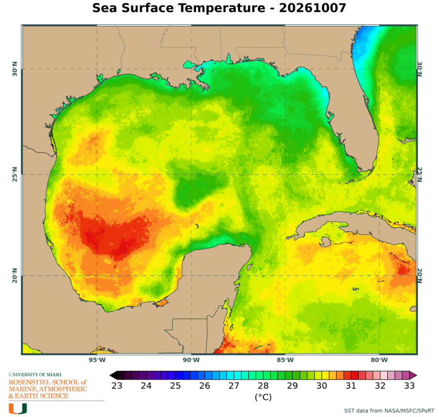
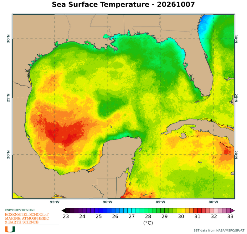
It’s passing over some slightly cooler SSTs right now
-
Hello all. Announcing something new on chescowx.com...ChescoWx Studies! This is an ongoing series looking at what makes Chester County's climate unique, this will include deep analysis of climate patterns and cycles, weather monitoring equipment and tools and past storm write ups and details. Each study takes one question, tests it against our station records and gives you the answer with the numbers behind it. I would welcome any feedback or pushback on the methods or the results. The series lives here and will grow as new studies are finished: https://chescowx.com/chescowx-studies/ Study 1 - Equipment & Siting. Three stations at my place in East Nantmeal. A ground-level fan-aspirated Davis, a rooftop Tempest and a ground-level Ambient with a passive shield. The Tempest highs ran about +3°F in July through September and +3.3°F on sunny, calm days, with 45 days of 90°F vs 8 for the Davis. To separate the roof from the shield, I looked at the Ambient. From 2021 to 2023 its summer highs matched the Davis within a few tenths while the Tempest was +2.8°F...so it is the roof, not the shield. Once the Ambient shield was damaged, though, it ran almost 7°F warm on sunny days. Location first, then upkeep. Study 2 - Elevation & Terrain. Most of our hilltop stations came along decades after the valley ones, and the weather varies from one decade to the next, so I compared them over the same years (2012 to 2025) using USGS 3DEP elevations. 19 stations with at least 8 complete years, by band: 100 to 300 ft (4 stations): high 64.4, low 43.6, 90 degree days 19, freezing nights 111, growing season 182 days 300 to 600 ft (8 stations): high 63.3, low 44.5, 90 degree days 11, freezing nights 101, growing season 192 days 600 ft and up (7 stations): high 62.3, low 45.3, 90 degree days 9, freezing nights 94, growing season 204 days Days follow elevation and nights follow terrain position. Highs drop about 1.7°F for every 300 ft, but lows track how far a station sits above its immediate surroundings, which is why they actually rise as you go up. For snow I used a same-storm comparison (521 storms, 60+ human-observed sites) so a snowy decade at one station does not skew it. Overall the hills get about 8% more snow for every 300 ft (29% per 1,000 ft), but the time of season matters a lot: Oct-Nov (24 storms) about 25% per 300 ft Dec-Jan (251 storms) about 6% Feb (151 storms) about 5% Mar-Apr (95 storms) about 18% March 2004 is a good example: East Nantmeal 11.0, Coatesville 2W 8.8 vs Exton 3.0, Chadds Ford 3.4, West Chester 2.2. There are always a few sites that do not fit, and the southern uplands around West Grove and New London run less than their elevation would suggest. The north also gets a bit more than the south, while the western part of the county gets more only because it is higher. Precipitation showed no elevation effect at all. Let me know if any questions, if you see anything that does not hold up, or if there is a question you would like to see tested next!
-
(002).thumb.png.6e3d9d46bca5fe41aab7a74871dd8af8.png)
E PA/NJ/DE Autumn 2026 Obs/Discussion
ChescoWx replied to PhiEaglesfan712's topic in Philadelphia Region
Hello all. Announcing something new on chescowx.com...ChescoWx Studies! This is an ongoing series looking at what makes Chester County's climate unique, this will include deep analysis of climate patterns and cycles, weather monitoring equipment and tools and past storm write ups and details. Each study takes one question, tests it against our station records and gives you the answer with the numbers behind it. I would welcome any feedback or pushback on the methods or the results. The series lives here and will grow as new studies are finished: https://chescowx.com/chescowx-studies/ Study 1 - Equipment & Siting. Three stations at my place in East Nantmeal. A ground-level fan-aspirated Davis, a rooftop Tempest and a ground-level Ambient with a passive shield. The Tempest highs ran about +3°F in July through September and +3.3°F on sunny, calm days, with 45 days of 90°F vs 8 for the Davis. To separate the roof from the shield, I looked at the Ambient. From 2021 to 2023 its summer highs matched the Davis within a few tenths while the Tempest was +2.8°F...so it is the roof, not the shield. Once the Ambient shield was damaged, though, it ran almost 7°F warm on sunny days. Location first, then upkeep. Study 2 - Elevation & Terrain. Most of our hilltop stations came along decades after the valley ones, and the weather varies from one decade to the next, so I compared them over the same years (2012 to 2025) using USGS 3DEP elevations. 19 stations with at least 8 complete years, by band: 100 to 300 ft (4 stations): high 64.4, low 43.6, 90 degree days 19, freezing nights 111, growing season 182 days 300 to 600 ft (8 stations): high 63.3, low 44.5, 90 degree days 11, freezing nights 101, growing season 192 days 600 ft and up (7 stations): high 62.3, low 45.3, 90 degree days 9, freezing nights 94, growing season 204 days Days follow elevation and nights follow terrain position. Highs drop about 1.7°F for every 300 ft, but lows track how far a station sits above its immediate surroundings, which is why they actually rise as you go up. For snow I used a same-storm comparison (521 storms, 60+ human-observed sites) so a snowy decade at one station does not skew it. Overall the hills get about 8% more snow for every 300 ft (29% per 1,000 ft), but the time of season matters a lot: Oct-Nov (24 storms) about 25% per 300 ft Dec-Jan (251 storms) about 6% Feb (151 storms) about 5% Mar-Apr (95 storms) about 18% March 2004 is a good example: East Nantmeal 11.0, Coatesville 2W 8.8 vs Exton 3.0, Chadds Ford 3.4, West Chester 2.2. There are always a few sites that do not fit, and the southern uplands around West Grove and New London run less than their elevation would suggest. The north also gets a bit more than the south, while the western part of the county gets more only because it is higher. Precipitation showed no elevation effect at all. Let me know if any questions, if you see anything that does not hold up, or if there is a question you would like to see tested next! -
looks like we're the second sub-forum to hit 1M posts. What should we do to celebrate?
-
Euro sends most of the rain to our south-what little gets here waits until about 5-6pm Sunday eve
-
Yep I was going to say the same thing... It just cannot keep the convection going.... every time it gets a burst, it fizzles out.
-
Looks like it's struggling. What else do you expect from #2026?
-
I don’t think that’s a legit eye, IR suggests that the inner core convection still isn’t organized enough yet to pop one. Pause in strengthening for now, let’s see if Isaias can get going again soon.
-
Last recon pass is up 2 mb to 978mb. Never seen a strengthening storm that doesn't lose any pressure for 5 hours ...
-

Brownsville Experiences Hottest September on Record
donsutherland1 replied to donsutherland1's topic in Climate Change
The September statewide data for Texas is now in. The heat of September 2026 made a mockery of the State's prior monthly record. September 2026 finished with a statewide mean temperature of 84.1°. 2023, the prior record, was left in the distant dust with a relatively cool 81.8°. September 2019 was further back in third with a mean temperature of 81.5°. -
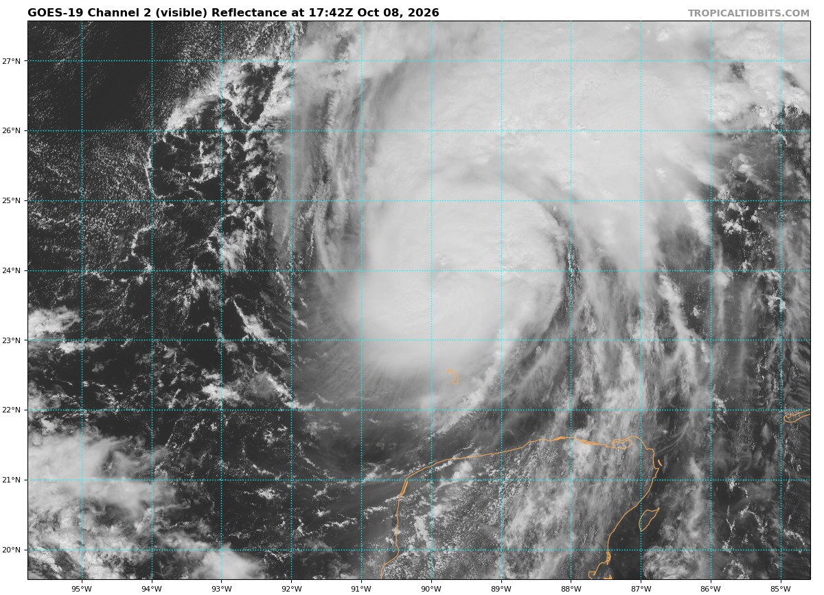
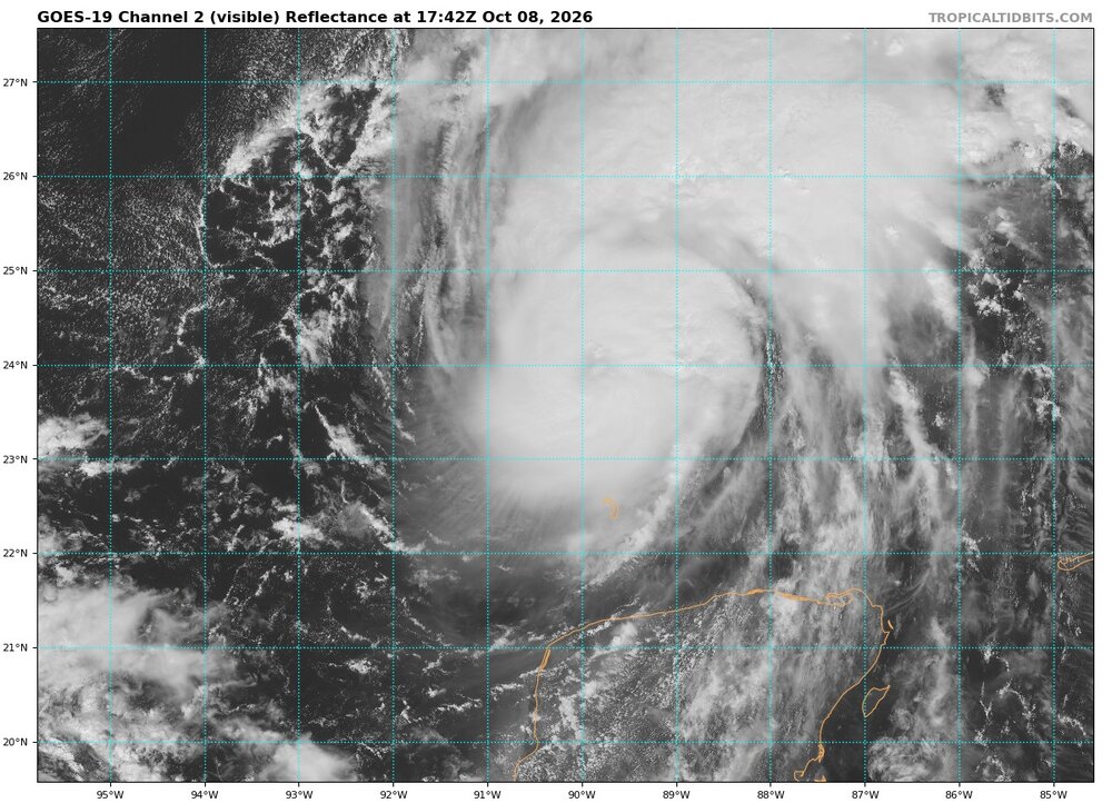
BULLETIN Hurricane Isaias Intermediate Advisory Number 8A NWS National Hurricane Center Miami FL AL092026 100 PM CDT Thu Oct 08 2026 ...ISAIAS EXPECTED TO STRENGTHEN FURTHER... ...PREPARATIONS TO PROTECT LIFE AND PROPERTY FROM STORM SURGE AND DAMAGING WINDS IN THE WARNING AREA SHOULD BE RUSHED TO COMPLETION TODAY... SUMMARY OF 100 PM CDT...1800 UTC...INFORMATION ---------------------------------------------- LOCATION...24.0N 89.8W ABOUT 185 MI...300 KM N OF PROGRESO MEXICO ABOUT 355 MI...570 KM S OF THE MOUTH OF THE MISSISSIPPI RIVER MAXIMUM SUSTAINED WINDS...85 MPH...140 KM/H PRESENT MOVEMENT...ENE OR 60 DEGREES AT 10 MPH...17 KM/H MINIMUM CENTRAL PRESSURE...975 MB...28.80 INCHES
-
You shouldn't be trying to wiggle at your age anyway! (Hi Kettle!!!)
-
Looking good with some nice ventilation going on even in the SW quadrent. Has about 24 hours to maximize itself before shear starts to really impinge.
-
I wouldn't be mad if several New Orleans Saints players had flooded basements that distracted them for the next few days
-
It appears the eye is starting to clear
-
Outside of the rain from the hurricane, the weather looks depressingly warm the next two weeks. We may not even get a frost in October, and I normally get a frost and freeze this month. Not long ago models were showing freezing temps around mid-month and even chances for mountain snow.
-
Meh....no wiggle room to the south for the north trend.
-
Best looking system by far this season and close to home. https://www.meteo.psu.edu/ewall/PSUGOES_US/loop60v.html Don't think this makes major status and thinking Cat 1 at landfall but spreading out as it landfalls. Jet interactions may make this just as bad or worse inland than at the coast. Winds will extend quite a distance inland with massive power outages. Ground is saturated along the gulf coast to boot. Lots of trees will come down. Tornado threat east of the track is going to be a problem as well. Surge will be the biggest issue at the coast I think. Also think NHC will continue to nudge track east a bit in future advisories. Places near landfall and to the right will get the worst of the winds and surge. West side could have not much going on with a lopsided system. In a more favorable atmospheric season with less shear this storm could have been much much worse. On par with some of the notorious systems of the past.
-
Yes. But GFS at 8 days….ya skeptical.
- Today
-
Yyyyyeeeeeeesssssssssss
-
Even though precise track may not be as important on Isaias as other more powerful storms, fwiw pretty much every 12z model trended east from prior runs. Heck, the 12z HMON is almost to Panama City Beach. 12z HAFS-B gains a whopping 32 mb of pressure in last 15 hours before landfall.