All Activity
- Past hour
-

Central PA Winter 25/26 Discussion and Obs
Itstrainingtime replied to MAG5035's topic in Upstate New York/Pennsylvania
Low this morning of 22 which was far lower than I expected after the events of last evening. I had some sort of inversion that sent my temp from 30.2 at 8pm up to 36.8 at 9pm. Temp plateaued there and was still at 35.1 at midnight. Was able to shave off 13 degrees during the early morning hours. -
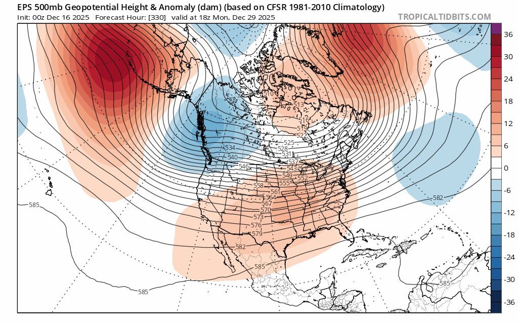
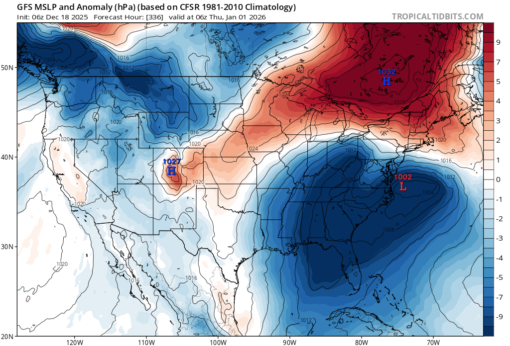
Classic setup with strong surface HP locked in right where we want it because of the block.

-

Central PA Winter 25/26 Discussion and Obs
pasnownut replied to MAG5035's topic in Upstate New York/Pennsylvania
17 lowest i saw on car digi outside of brunnerville this AM. as i stated the other day, pattern twds eoy looks to be flattening, w/ AO/NAO both headed into - territory. PNA/EPO also - which says zonal baby. As blizz suggested, which side of the boundary we are on is the challenge. OP's seem to be catchin onto the regime shift and hopefully adjust to better looks. How long does it last...million$$ question. Lastly the wonky evolution early in the new year is rather fun to see, and a couple models showing wonkiness at varying levels, but we get snow, so I'm in for the ride no matter if we derail or not. -

Central PA Winter 25/26 Discussion and Obs
Mount Joy Snowman replied to MAG5035's topic in Upstate New York/Pennsylvania
Low of 26. Going to enjoy my last day of full snow coverage before the heavy rains hit tonight. Still a beautiful scene out there. Quite a memorable start to December. -

December 2025 regional war/obs/disco thread
weatherwiz replied to Torch Tiger's topic in New England
I love the euro op phasing of a TPV piece with southern stream energy across the Carolinas towards the end of the run lol -
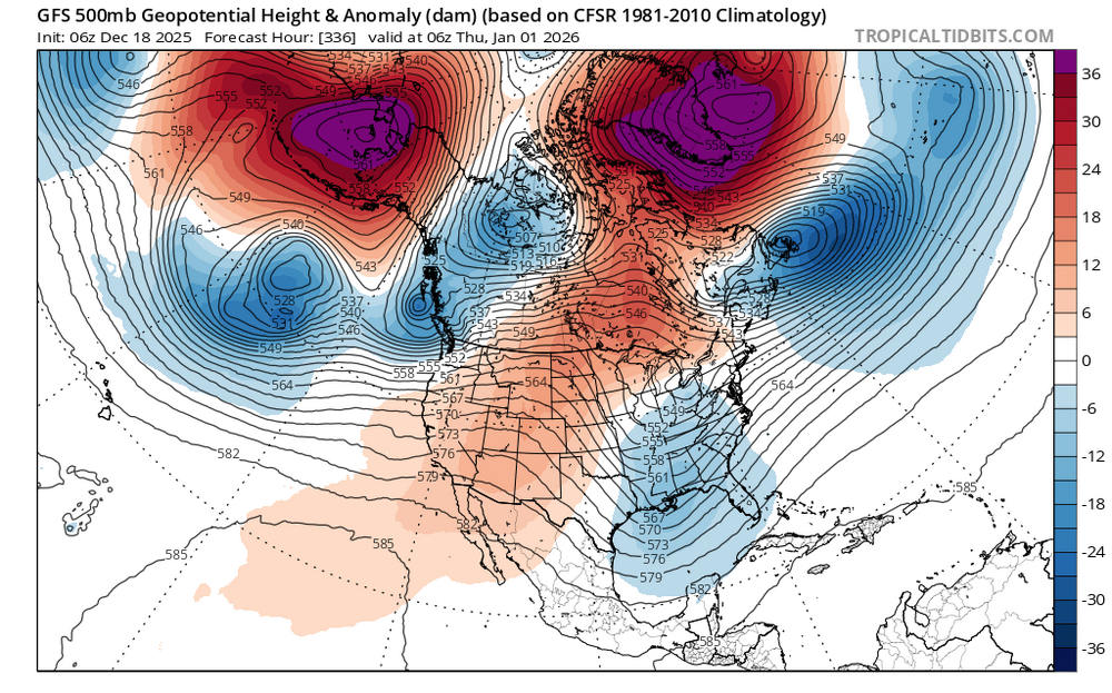
Fwiw, 6z AIGFS has essentially the same threat as the Gfs, just a bit more "realistic"?
.thumb.png.980dfbbe206e7db5e553472cce25398e.png)
-

Central PA Winter 25/26 Discussion and Obs
paweather replied to MAG5035's topic in Upstate New York/Pennsylvania
Looks good Blizz. Hope we can capitalize on one or both of these in the next few weeks -

December 2025 regional war/obs/disco thread
The 4 Seasons replied to Torch Tiger's topic in New England
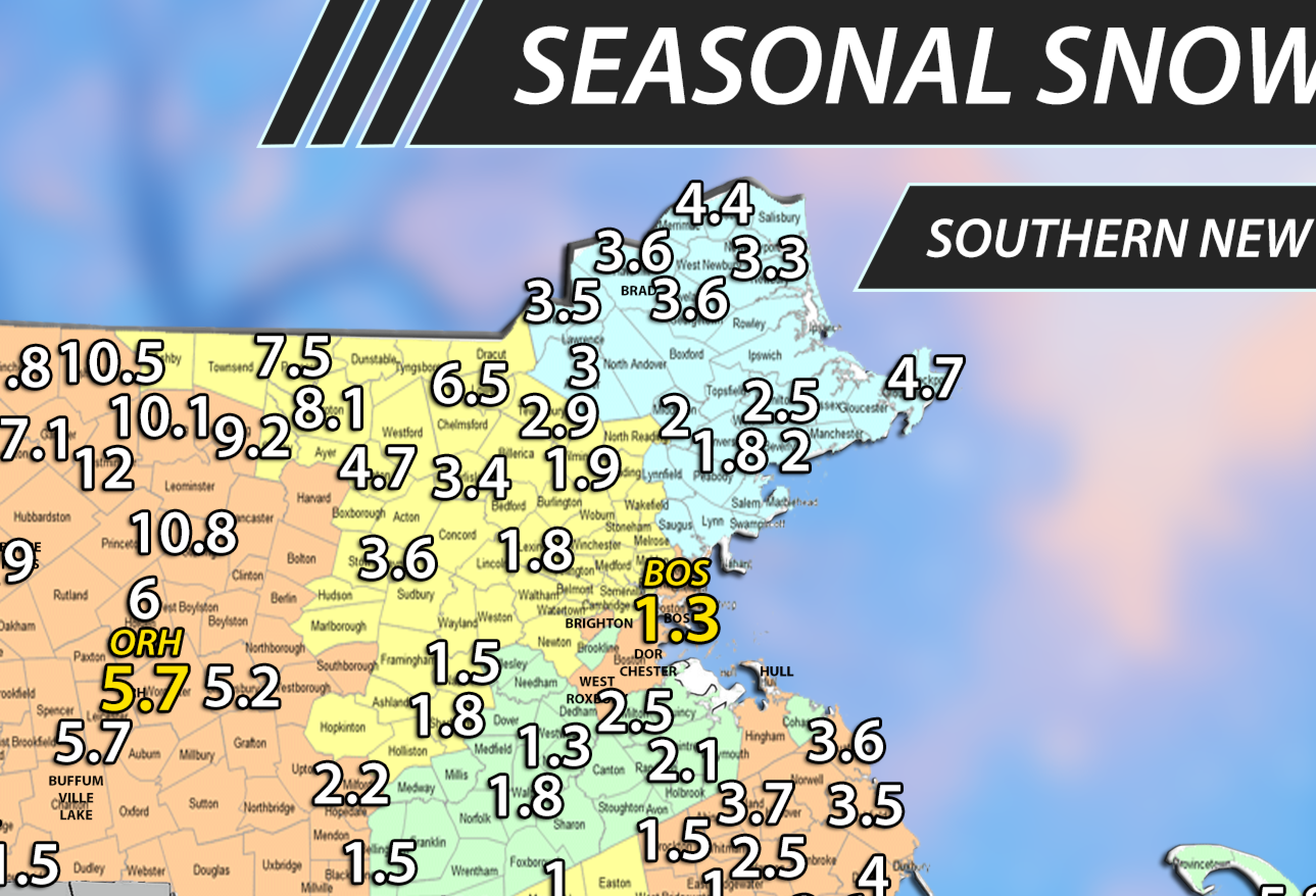
doesnt fit, got 1.7" already in killingly from cocorahs so youll have to settle for that lmao updated -

December 2025 regional war/obs/disco thread
brooklynwx99 replied to Torch Tiger's topic in New England
one of the only things that can really alleviate a shit Pacific with -WPO is a strong west based -NAO… just shunts everything west and changes the Pacific alignment -
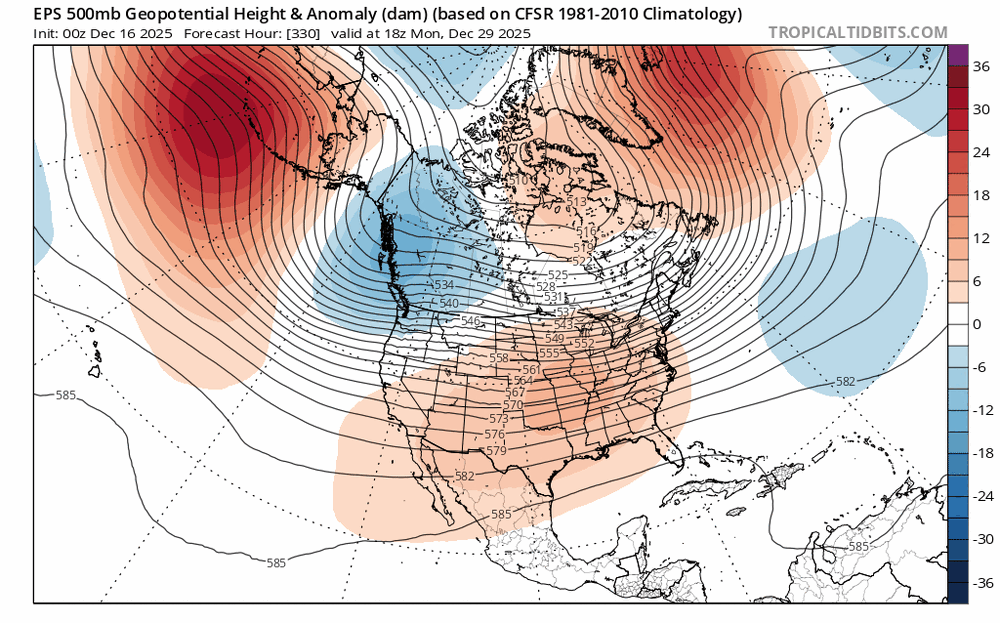
GFS is further expansive east with the ridge and the Euro had a cutoff building NE to SW in the Dec 30 period.
-

December 2025 regional war/obs/disco thread
Kitz Craver replied to Torch Tiger's topic in New England
Just took a look at the 0z EURO, that’s a pretty wild run -
Do you have to let it?
-
December 2025 regional war/obs/disco thread
The 4 Seasons replied to Torch Tiger's topic in New England
oh i put you at 3.5" just based on my quick thinking from last storm you said 1 and the previous 2.5, so i got 3.5 but i can quickly fix that. I have a town overlay so i put everyone in the middle of the town unless i know exactly where they are. ill change it to 3.8
-
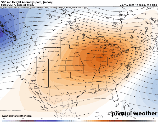
This will be a good test for the AIFS EPS coming up since it matches the composite more than the EPS with the further east ridge axis.
-

December 2025 regional war/obs/disco thread
Sey-Mour Snow replied to Torch Tiger's topic in New England
Let’s get a Jan 2016 repeat -

December 2025 regional war/obs/disco thread
40/70 Benchmark replied to Torch Tiger's topic in New England
No question this eclipses the late 80's-early 90's stretch if this season sucks...they are like Brady and Mahomes for suckage spell GOATs right now....but this year would put 2020s ahead. -

December 2025 regional war/obs/disco thread
Cold Miser replied to Torch Tiger's topic in New England
The 1"+ that I got on Sunday managed to linger on into today. At least it was a holiday feel for a few days. -
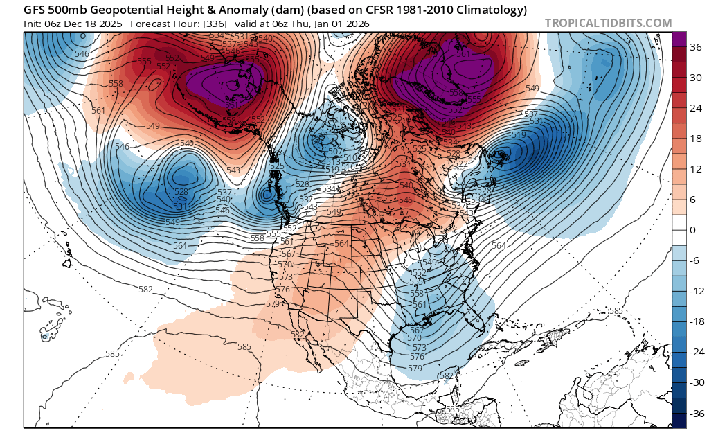
Especially given the -PNA and the very amplified PAC jet crashing into the PAC NW, that would make sense (omega ridge rolled over further east from the dead center of the CONUS position) that the models show right now
-
Its all cyclical. You will get another snowfall bonanza across multiple seasons again. My largest snowfall drought lasted 30 years before 2000 so I am not too hopefull for anytime soon IMBY lol.
-
Yeah that westward trend has put us from toucans, to shots of cold, to having room to dig these shortwaves and curve something up the coast at our latitude and a little blocking will help with that. I think I saw a fantasy run yesterday in the extended that retrograded at our latitude as well. Everyone up here starts getting anxiety now when the NAO starts getting too negative, but I feel like this may be a time we’d want it…unless everyone is happy with quick hitting light-mod events.
-
December 2025 regional war/obs/disco thread
Cold Miser replied to Torch Tiger's topic in New England
You forget my measly 1.25. -
You would think something would work out.
-
not bad
-
2025-2026 ENSO
40/70 Benchmark replied to 40/70 Benchmark's topic in Weather Forecasting and Discussion
I would take a deep and quick plunge right into the Merrimack....I just can't anymore. -
@H2Obringing it


.png.18456cb895c557208cd91360460b481c.png)