All Activity
- Past hour
-

November 2025 general discussions and probable topic derailings ...
kdxken replied to Typhoon Tip's topic in New England
-

November 2025 general discussions and probable topic derailings ...
dryslot replied to Typhoon Tip's topic in New England
Teens again here. -

-

November 2025 general discussions and probable topic derailings ...
Typhoon Tip replied to Typhoon Tip's topic in New England
26 here already -
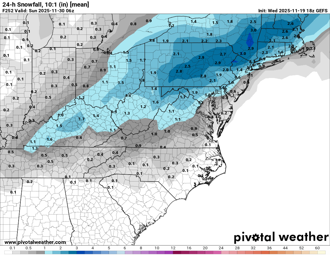
Respectable GEFS mean for this range in November, for the very little that’s worth. Can’t see individual members, would wager it’s pulling in a heavy outlier or two.
-

2025-2026 ENSO
donsutherland1 replied to 40/70 Benchmark's topic in Weather Forecasting and Discussion
I used the NE as an example, because it seemed that a lot of the commentary had been focused on the NE U.S. -
A Scandi block retrograding into the NAO space is what happened in early winter 2009. We know how that turned out. Just sayin. Ofc that was a Nino so results may vary lol.
-
November 2025 general discussions and probable topic derailings ...
Typhoon Tip replied to Typhoon Tip's topic in New England
That’s always possible in fast flow but those look spaced reasonably well. It also helps that they’re both flat waves and probably more middling intensity -
31 now.
-
About as good as we can hope for early on in the season. If we can manage to squeeze out a 2-4/3-6 type event before dec 20th I’d be thrilled.
-
November 2025 general discussions and probable topic derailings ...
Typhoon Tip replied to Typhoon Tip's topic in New England
I don’t understand what the big deal is with the Epstein files anyway… you’re not gonna be seeing the real ones anyway. The only reason why there’s any kind of impetus to release those files finally is because they’re finally done redacting them – obviously -

November 2025 general discussions and probable topic derailings ...
WinterWolf replied to Typhoon Tip's topic in New England
ObiWon never told Judah what happened to his father…Scoots is your father.
-
I like this h5 look for early Dec. Scandi ridge building into the NAO domain plus a +PNA/-EPO.
-

November 2025 general discussions and probable topic derailings ...
dendrite replied to Typhoon Tip's topic in New England
Anyway…we’ll see. We all know these get a little overhyped before they start propagating down to the lower strat. As always, give me a decent pack before the arctic hounds arrive Looks like another chilly one tonight. Should be a lot of low 20s in CNE. -
Absolutely they've looked/been worse but last year was cold and slightly AN snow for my area including a solid white Christmas but Dec climo is much stronger here as well. Second morning in the mid-teens and large ponds held ice all day despite ample sun. Matter of time now and seeing if a decent system can come together to kick-start the December party.
-
November 2025 general discussions and probable topic derailings ...
dendrite replied to Typhoon Tip's topic in New England
Scoot: “Judah…I am your daddy” -
Below normal temperatures will prevail through tomorrow. Highs will be mainly in the middle and upper 40s in New York City with lows in the middle and upper 30s. A milder pattern will then develop afterward. Some rain or rain showers are possible. Once in place, the milder pattern will likely continue into the closing days of November. However, exceptional warmth appears unlikely. The closing days of November could turn cooler. Meanwhile, today will be Central Park's 1,390th consecutive day without daily snowfall of 4" or more. The record of 1,394 days was set during February 22, 1929 through December 16, 1932. That stretch ended with 6.7" daily snowfall on December 17, 1932. The ENSO Region 1+2 anomaly was -0.7°C and the Region 3.4 anomaly was -0.7°C for the week centered around November 12. For the past six weeks, the ENSO Region 1+2 anomaly has averaged -0.16°C and the ENSO Region 3.4 anomaly has averaged -0.65°C. La Niña conditions will likely continue through at least mid-winter. The SOI was +38.30 today. That is the highest SOI value since December 23, 2022 when the SOI reached +50.96. The preliminary Arctic Oscillation (AO) was -1.027 today. Based on sensitivity analysis applied to the latest guidance, there is an implied 74% probability that New York City will have a cooler than normal November (1991-2020 normal). November will likely finish with a mean temperature near 47.1° (0.9° below normal). Supplemental Information: The projected mean would be 0.6° below the 1981-2010 normal monthly value.
-
November 2025 general discussions and probable topic derailings ...
dendrite replied to Typhoon Tip's topic in New England
What will we get first? Epstein files GTA6 Consequential SSW -
Currently: Clear. Calm. 29.4°
-
November 2025 general discussions and probable topic derailings ...
WinterWolf replied to Typhoon Tip's topic in New England
Luke Cohen Skywalker…? -

Central PA Fall Discussions and Obs
pawatch replied to ChescoWx's topic in Upstate New York/Pennsylvania
31 degrees already, going to be a cold one in the morning. Maybe Some of you should close the bedroom window tonight. -

Pittsburgh PA Fall 2025 Thread
Ahoff replied to TheClimateChanger's topic in Upstate New York/Pennsylvania
Well, we gotta at least have the chance first, and so far step 1 is accomplished. We'll see from there. -

November 2025 general discussions and probable topic derailings ...
weathafella replied to Typhoon Tip's topic in New England
Too much emphasis and living and dying with the possibility of a SSW event. Tip pretty much put it in perspective when he reminded us to keep your eye on 50,000 feet lower-H5 with his reference to the epo/wpo. -

November 2025 general discussions and probable topic derailings ...
Torch Tiger replied to Typhoon Tip's topic in New England
We're on the hype train...bottoms up -
November 2025 general discussions and probable topic derailings ...
dendrite replied to Typhoon Tip's topic in New England
Return of the Judi