All Activity
- Past hour
-

Spooky Season (October Disco Thread)
CoastalWx replied to Prismshine Productions's topic in New England
Windy this morning. -

Central PA Fall Discussions and Obs
mahantango#1 replied to ChescoWx's topic in Upstate New York/Pennsylvania
48 this morning. -
Low 60 and pleasantly dry DP 52. First day my DP has gone below 60 since Sept 22.
-
Didn't have to wait that long lol He tore me a new one via text just after the game last night
-
-

2025-2026 ENSO
40/70 Benchmark replied to 40/70 Benchmark's topic in Weather Forecasting and Discussion
CFS is MUCH warmer.....my stuff is seemingly a compromise of the two. -
2025-2026 ENSO
40/70 Benchmark replied to 40/70 Benchmark's topic in Weather Forecasting and Discussion
Even more pronounced for JFM:
-
2025-2026 ENSO
40/70 Benchmark replied to 40/70 Benchmark's topic in Weather Forecasting and Discussion
DJF hardly below normal from around the N shore of Boston points NE into Maine screams late-blooming Miller B, to me.
-
 Oh boy a few hours late sorry DCA _NYC _BOS _ ORD _ATL _IAH __ DEN _PHX _SEA +2 +2.3 +2.4 +3.5 +1.6 +2.1 +1.4 +1 +1.6
 -

Spooky Season (October Disco Thread)
512high replied to Prismshine Productions's topic in New England
Hello October ! Jeez, another month flew by... low 47F feels great! -
2025-2026 ENSO
40/70 Benchmark replied to 40/70 Benchmark's topic in Weather Forecasting and Discussion
JFM looks around normal precip for most of SNE....precip is probably the most inaccurate aspect of seasonals, anyway, which remain relatively inaccurate in general. Seems like there maybe some late developing Miller B events that are going to pop in the N stream. Latest run has picked up on this more, as it's not as dry in New England. -
49° quite a change.
-
Yep. It did get cooler for Dec-Mar in the northeast since the last update, but boy does it have a strong dry signal from November-March in the east, with the lone exception of eastern New England for March like you said. That dry signal increased since the last update
-

Central PA Fall Discussions and Obs
Mount Joy Snowman replied to ChescoWx's topic in Upstate New York/Pennsylvania
Low of 57. A splendid few days on tap. -

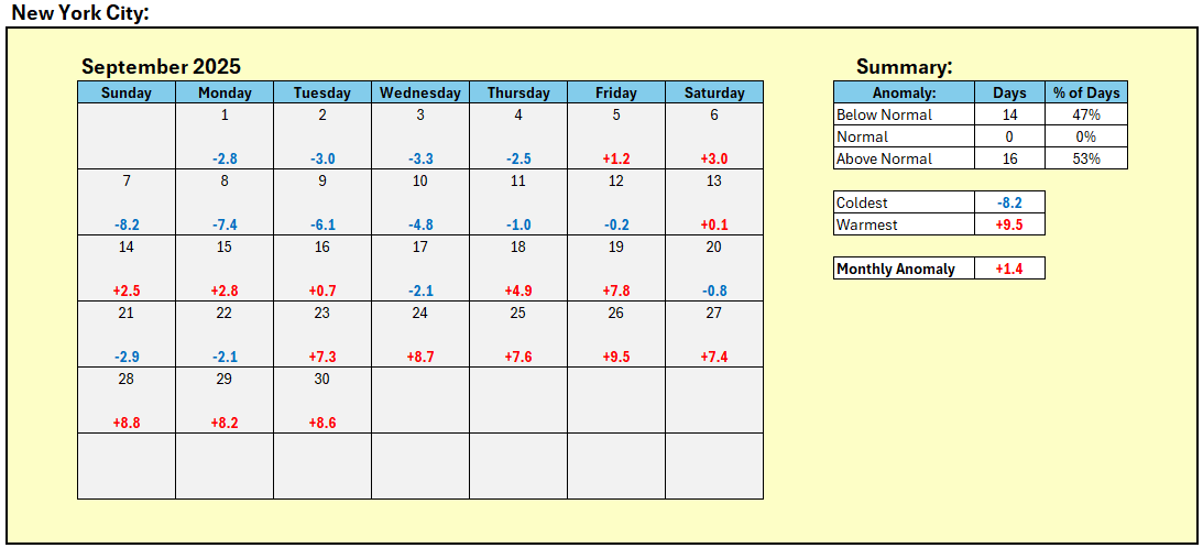
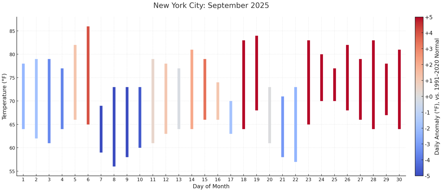
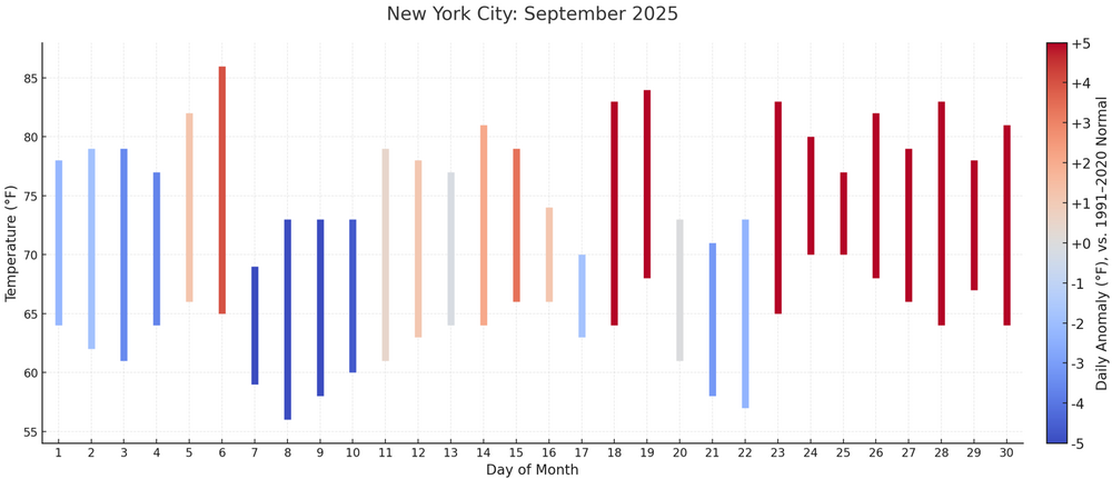
September 2025 OBS-Discussion centered NYC subforum
bluewave replied to wdrag's topic in New York City Metro
Several stations came within a few degrees of their warmest high for the last week of September. Time Series Summary for SUSSEX AIRPORT, NJ Click column heading to sort ascending, click again to sort descending. 1 2017-09-30 89 0 2 2014-09-30 88 0 - 2007-09-30 88 0 3 2025-09-30 87 0 4 2010-09-30 85 0 5 2018-09-30 82 0 - 2011-09-30 82 0 Time Series Summary for NEWARK LIBERTY INTL AP, NJ Click column heading to sort ascending, click again to sort descending. 1 2017-09-30 92 0 - 1959-09-30 92 0 - 1881-09-30 92 0 2 1998-09-30 91 0 - 1970-09-30 91 0 3 2010-09-30 90 0 - 2007-09-30 90 0 - 1968-09-30 90 0 - 1958-09-30 90 0 - 1895-09-30 90 0 4 2025-09-30 89 0 - 1986-09-30 89 0 - 1945-09-30 89 0 - 1933-09-30 89 0 Time Series Summary for ISLIP-LI MACARTHUR AP, NY Click column heading to sort ascending, click again to sort descending. 1 2017-09-30 89 0 2 2010-09-30 87 0 3 1998-09-30 86 0 4 2025-09-30 85 0 - 1970-09-30 85 0 5 2009-09-30 83 0 - 1972-09-30 83 0 - Today
-

September 2025 OBS-Discussion centered NYC subforum
donsutherland1 replied to wdrag's topic in New York City Metro
Final September mean temperature in New York City: 70.6° September 2025 had the second smallest standard deviation in temperatures for any September. Lowest Standard Deviations: 1. 1968 3.43° 2. 2025 3.63° 3. 1870 3.81° 4. 2024 3.94° 5. 1908 4.08° Standard Deviations in the New York City Area: Bridgeport: 3.60° (old record: 3.72°, 2024) Islip: 4.11° (3rd lowest) New York City-Central Park: 3.63° (2nd lowest) New York City-JFK Airport: 3.64° (2nd lowest) New York City-LaGuardia Airport: 3.82° (2nd lowest) Newark: 4.19° (3rd lowest) White Plains: 4.02° (old record: 4.28°, 1968)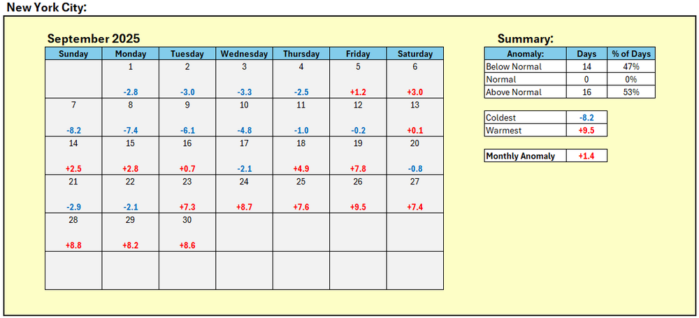
-
October's Cansip run looks a lot like September's fwiw. Cooler up north of MD/PA line but on the dry side, except for March in ENE. 5H starts here: https://www.tropicaltidbits.com/analysis/models/?model=cansips®ion=namer&pkg=z500a&runtime=2025100100&fh=5
-
Fwiw, Cansips updated October forecast for D-F looks a lot like last month's of around normal to slightly above as you head south. Temps https://www.tropicaltidbits.com/analysis/models/?model=cansips®ion=eus&pkg=T2maMean_month&runtime=2025100100&fh=4 H5 https://www.tropicaltidbits.com/analysis/models/?model=cansips®ion=namer&pkg=z500aMean_month&runtime=2025100100&fh=4
-
This drought situation is actually worse than last year at this time. We have been completely devoid of widespread heavy rains in the Northeast and Mid-Atlantic since late July. October looks dry as far as the eye can see
-
That will also be our next chance of rain it appears. As modeled its a pretty impressive digging trough with associated shortwave energy. In the days prior to that we will probably have some of the dreaded October warmth with dewpoints creeping up as high pressure shifts into the western Atlantic.
-
Not that I’ve seen yet. I’ll let you know. The only thing he’s really commented on is that he doesn’t believe the “warm blob” is going to last into the winter and thinks a classic ‘cold horseshoe’ -PDO alignment is going to develop
-
Up to 90mph at latest advisory
-
Imelda has become significantly better defined overnight with a large eye and more cohesive convection. Strengthens appears imminent.
-
 Oops.. 1 hour late DCA: +3.2 NYC: +3.5 BOS: +3.5 ORD: +5.7 ATL: +2.9 IAH: +2.5 DEN: +0.5 PHX: +0.2 SEA: 0.0
 -

Spooky Season (October Disco Thread)
Snowedin replied to Prismshine Productions's topic in New England
Pretty breezy out there tonight! Sadly any rain or appreciable moisture will have to wait a while longer.