All Activity
- Past hour
-

Saturday 9/6 Strong/Severe storm potential
DavisStraight replied to Torch Tiger's topic in New England
I may go to the top of Mt Agementicus -
department of west atlantic ridges
-

September 2025 OBS-Discussion centered NYC subforum
Picard replied to wdrag's topic in New York City Metro
We need the southern part to develop right. It did the other night. These set ups are always a bit iffy to me, I always tell people to watch for things popping up, but not to plan their day around it. -

2025-2026 ENSO
michsnowfreak replied to 40/70 Benchmark's topic in Weather Forecasting and Discussion
They are very biased towards enso and also biased towards a warmer climate. That is why periods of cold are never seen far out, you will see them grow colder as the timeframe nears. -
2025-2026 ENSO
michsnowfreak replied to 40/70 Benchmark's topic in Weather Forecasting and Discussion
1000%. I can't speak for the east coast, but here in Michigan it absolutely would have snowed more synoptically if it wasnt as cold and dry as it ended up. It snowed nearly every day for long stretches much of winter, yet we finished over a foot below normal. That is as anti "new climate" as you can get. -

September 2025 OBS-Discussion centered NYC subforum
MANDA replied to wdrag's topic in New York City Metro
Certainly what is on radar now is moving briskly along to the NE. Not like the other night with slow moving training batches of rain....at least so far. -
Someone around here will break the tornado “drought” today/tonight
-
2025-2026 ENSO
michsnowfreak replied to 40/70 Benchmark's topic in Weather Forecasting and Discussion
If most here follow model longterm seasonal snowfall forecasts over anything else, we have a problem . A longterm snowfall model forecast is probably the least accurate thing out there. Temp/precipitation bad enough....but snowfall? Model snow maps are to be taken with a grain of salt 48 hours out, much less 7 months out. -
September 2025 OBS-Discussion centered NYC subforum
Picard replied to wdrag's topic in New York City Metro
Some stuff may be developing, or develop later, but isn't what we are currently seeing already quite a bit north of the models? -
September 2025 OBS-Discussion centered NYC subforum
MANDA replied to wdrag's topic in New York City Metro
You made the right choice! You also got people under 55 out of the heat and humidity -
I remember attending an outdoor (I think summer) wedding. It was uncomfortable lol. I’d much rather be moving around than sitting there shvitzing and acting like a mosquito magnet.
-
Think Weetwrn MA into lakes region today
-
Now I’m hesitating because the TDWRs are also showing elevated reflectivity. I can see some bugs flying around, so it isn’t impossible. I don’t know why Dover wouldn’t be showing the same though.
-

Saturday 9/6 Strong/Severe storm potential
Damage In Tolland replied to Torch Tiger's topic in New England
I’d stay in CT -
Welcome to the club. Lava Rock 2 Sent from my SM-S921U using Tapatalk
-
Not a great shot on the phone but getting a little of the air show over here. Hopefully they get it in tomorrow too but doesn’t look great.
-
I think your answer is a lot more plausible than this
-
I think I am going to go into southwest New Hampshire (Walpole area where my friend works). Thinking there is potential sfc winds may end up a bit more backed up in that area. But I am going to have to leave like now. Its about a 90 minute hike there
-

September 2025 OBS-Discussion centered NYC subforum
RU848789 replied to wdrag's topic in New York City Metro
A little ominous...SPC just issued a mesoscale discussion stating that severe weather watches are likely for our area for this afternoon/evening. Mesoscale Discussion 2042 NWS Storm Prediction Center Norman OK 1056 AM CDT Sat Sep 06 2025 Areas affected...Parts of New England into the northern Mid Atlantic Concerning...Severe potential...Watch likely Valid 061556Z - 061730Z Probability of Watch Issuance...80 percent SUMMARY...Strong to severe storm development is possible by early afternoon. Issuance of one or more watches is likely. DISCUSSION...Filtered heating is ongoing late this morning from parts of NJ/eastern PA into parts of New England, to the east of a substantial cloud shield and embedded weak convection. Morning soundings depict generally poor midlevel lapse rates, but relatively rich low-level moisture (with dewpoints in the 60s to near 70 F) and continued heating will result in MLCAPE increasing to the 1000-1500 J/kg range. Scattered surface-based storm development is expected as soon as early afternoon, as a cold front begins to impinge upon this destabilizing environment. Deep-layer shear is already rather strong across the region, and will continue to increase in response to a notable mid/upper-level shortwave trough approaching the lower Great Lakes region. Initial development may quickly evolve into a few supercells, though deep-layer flow/shear roughly parallel to the front may eventually result in a tendency toward storm clustering and possible QLCS development. Some increase in low-level shear/SRH with time could support a tornado threat with any discrete or embedded supercells, especially where surface winds remain locally backed near a weak surface wave that will traverse the front this afternoon. Isolated hail may also occur with any supercells. Otherwise, scattered damaging wind will become increasingly possible with time, as storm coverage increases and low-level lapse rates steepen. One or more watches will likely be issued by early afternoon in order to cover these threats. https://x.com/NWSSPC/status/1964357439077200126 -

Saturday 9/6 Strong/Severe storm potential
Torch Tiger replied to Torch Tiger's topic in New England
missed this earlier. 80% Probability of Watch Issuance...80 percent SUMMARY...Strong to severe storm development is possible by early afternoon. Issuance of one or more watches is likely. DISCUSSION...Filtered heating is ongoing late this morning from parts of NJ/eastern PA into parts of New England, to the east of a substantial cloud shield and embedded weak convection. Morning soundings depict generally poor midlevel lapse rates, but relatively rich low-level moisture (with dewpoints in the 60s to near 70 F) and continued heating will result in MLCAPE increasing to the 1000-1500 J/kg range. Scattered surface-based storm development is expected as soon as early afternoon, as a cold front begins to impinge upon this destabilizing environment. Deep-layer shear is already rather strong across the region, and will continue to increase in response to a notable mid/upper-level shortwave trough approaching the lower Great Lakes region. Initial development may quickly evolve into a few supercells, though deep-layer flow/shear roughly parallel to the front may eventually result in a tendency toward storm clustering and possible QLCS development. Some increase in low-level shear/SRH with time could support a tornado threat with any discrete or embedded supercells, especially where surface winds remain locally backed near a weak surface wave that will traverse the front this afternoon. Isolated hail may also occur with any supercells. Otherwise, scattered damaging wind will become increasingly possible with time, as storm coverage increases and low-level lapse rates steepen. One or more watches will likely be issued by early afternoon in order to cover these threats. -

September 2025 OBS-Discussion centered NYC subforum
SACRUS replied to wdrag's topic in New York City Metro
-
September 2025 OBS-Discussion centered NYC subforum
SACRUS replied to wdrag's topic in New York City Metro
Records: Highs: EWR: 98 (2018) NYC: 97 (1881) LGA: 96 (2018) JFK: 93 (2023) Lows: EWR: 48 (1938) NYC: 48 (1924) LGA: 53 (1988) JFK: 52 (1963) Historical: 1667: The “dreadful hurricane of 1667” is considered one of the most severe hurricanes ever to strike Virginia. On the first, this same storm was reported in the Lesser Antilles. The hurricane devastated St. Christopher as no other storm had done before. The "great storm" went on to strike the northern Outer Banks of North Carolina and southeastern Virginia. Area crops (including corn and tobacco) were beaten into the ground. 1776: Called the Pointe-à-Pitre hurricane, this storm is one of the deadliest Atlantic hurricanes on record. While the intensity and complete track are unknown, this storm struck Guadeloupe on this day, killing 6,000. 1881 - Forest fires in Michigan and Ontario resulted in 'Yellow Day' in the northeastern U.S. Twenty villages in Michigan burned, and a total of 500 persons were killed. Fires caused 2.3 million dollars in losses near Lake Huron. Candles were needed at the noon hour. (David Ludlum) 1881: Forest fires in “The Thumb” of Michigan and Ontario resulted in “Yellow Day” over the New England states. Twenty villages and over a million acres burned in Michigan. The smoke from these fires caused the sky to appear yellow over several New England cities. Twilight appeared at noon on this day. 1929 - Iowa's earliest snow of record occurred as a few flakes were noted at 9 AM at Alton. (The Weather Channel) 1933: The remnant low of the Treasure Coast Hurricane dumped 10.33" of rain in Charleston, which is the second-highest 24-hour rainfall total on record for the downtown station. The storm produced wind gusts of 51 mph and also spawned a tornado near the city. 1987 - Thunderstorms produced more than seven inches of rain in Georgia. Four persons drowned, and two others suffered injury, as three couples attempted to cross Mills Stone Creek at Echols Mill in their automobile. Smoke from forest fires in California and Oregon spread across Utah into western Colorado. (The National Weather Summary) (Storm Data) 1988 - Unseasonably cool weather prevailed across the north central and northeastern U.S. Thirty cities reported record low temperatures for the date, including Saint Joseph MO with a reading of 38 degrees. A low of 44 degrees at Indianapolis IN was their coolest reading of record for so early in the season. The mercury dipped to 31 degrees at Hibbing MN and Philips WI. (The National Weather Summary) 1989 - An early afternoon thunderstorm produced wind gusts to 104 mph at Winterhaven, FL, flipping over four airplanes, and damaging five others. The high winds also damaged a hangar and three other buildings. A cold front produced strong winds and blowing dust in the Northern High Plains, with gusts to 54 mph reported at Buffalo SD. Powerful Hurricane Gabrielle and strong easterly winds combined to create waves up to ten feet high along the southern half of the Atlantic coast. (The National Weather Summary) (Storm Data) 2003: Hurricane Isabel was first named on September 6th, 2003. It would reach Category 5 status and eventually make landfall in North Carolina as a Category 2. 2017: Category 5 Hurricane Irma affected the US Virgin Island and Puerto Rico. Maximum sustained winds were at 180 mph when the storm hit St. Thomas & St. John. Catastrophic damage was reported over the US Virgin Island & significant damage over Puerto Rico, especially over Culebra. -
September 2025 OBS-Discussion centered NYC subforum
SACRUS replied to wdrag's topic in New York City Metro
86 / 70 clouds pushing east - race to 90 in the hottest spots. Onshore flow this week keeps it near normal, overall warmer by nexy weekend / mid month and beyond. https://cdn.star.nesdis.noaa.gov/GOES19/ABI/SECTOR/eus/02/GOES19-EUS-02-1000x1000.gif -
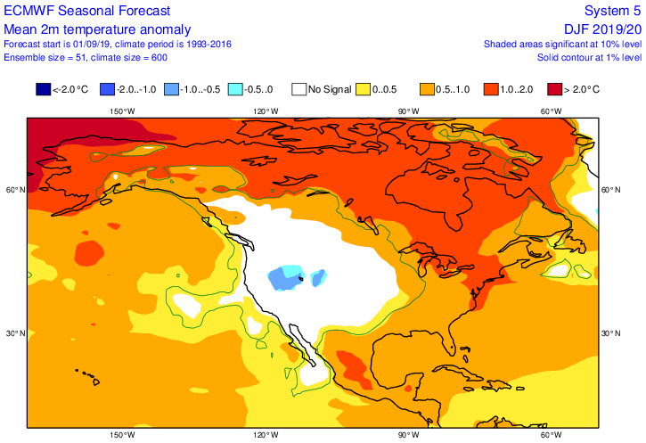
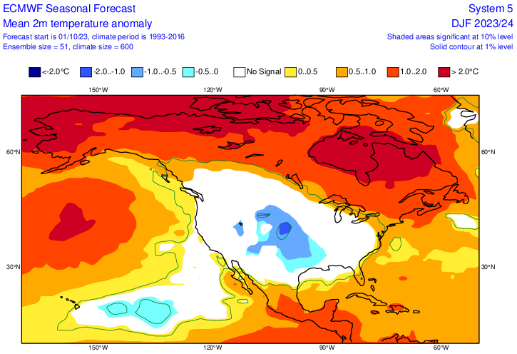
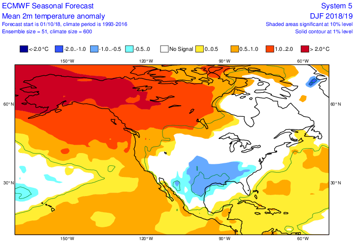
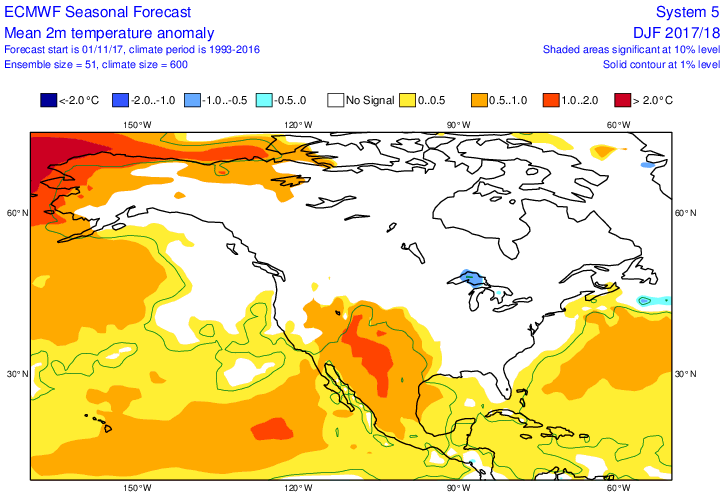
Regarding all 9 Euro DJF fcasts issued in Sept since 2017-8 (as far back as can be seen at the Euro site), there wasn’t even a tiny speck of BN anywhere in the lower 48 E of 110W long. The only one that had any BN anywhere in the lower 48 was the 2019-20 fcast, which had a small area of ~-1F in a small part of the Mtn W (which amazingly enough ended up being the only area with BN): Despite that, there were notable areas of actual BN in portions of the lower 48 in all of these DJFs except 2019-20 and 2023-4. So, your statement ECM is now incapable of seeing below normal temps has essentially been true for its Sept fcasts since 2017-8. However, two of its 8 Oct fcasts and one of its Nov fcasts for DJF did have some BN: Oct ‘23, which failed as there was no BN in the lower 48: Oct ‘18, which got the BN in KS right but the rest of this BN area ended up NN or AN and also it missed the widespread BN in NW 1/2 of the US: Nov ‘17 in UP of Mich, which was correct, but it missed the widespread BN in the Midwest, Plains, and N Rockies:
-
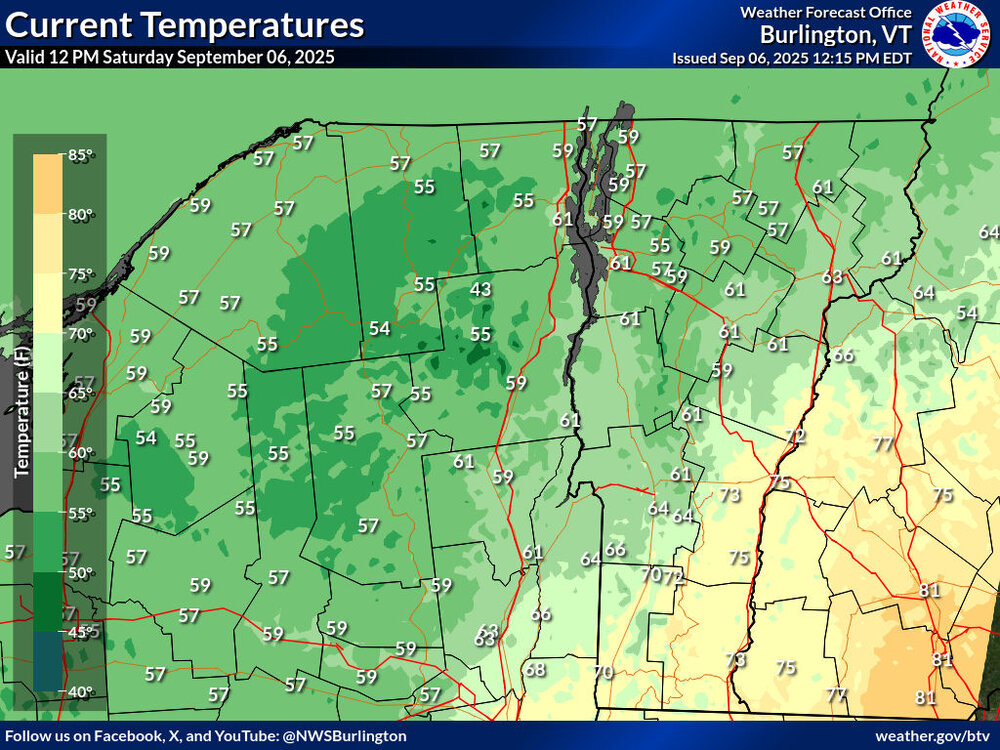
What a disaster of a Saturday. Steady synoptic rain, 1/3rd of an inch so far. 55F at 1500ft here at the mountain and 59F down at the ASOS. 50s and rain, just like a January thaw.