All Activity
- Past hour
-
Euro has more rain tomorrow than today.
-
Or it’s perfect for those who want a lazy weekend reading books
-
This weather blows.
-
I slept with the windows open 55 here
-
Same Working all weekend
-
2.22" since Wednesday for me as of 8:15am this morning.
-
5/22: .44” .46” so far today
-
Yeah. I was just looking at totals and we actually did better than I thought overnight. It looks like today we could catch up a bit. Models look great.
-
I'm out and about.. perfect weekend incoming
-
Other than a boomer in Methuen and someone living in a cave in nrn ORh county, weekend blows for all.
-

Chester County PA - Analytical Battle of Actual vs. Altered Climate Data
chubbs replied to ChescoWx's topic in Climate Change
The difference in slope is not statistically significant. Note that the Avondale USHCRN station has a higher slope than PHL. Are you saying that there is a UHI problem there? -

Central PA Spring 2026 Discussion/Obs Thread
Blizzard of 93 replied to Voyager's topic in Upstate New York/Pennsylvania
49 & rain in Marysville currently. .53 of rain today so far .92 this week total so far. -
Will be fun looking back on this when it’s 70/63 at Christmas.
-

Central PA Spring 2026 Discussion/Obs Thread
Voyager replied to Voyager's topic in Upstate New York/Pennsylvania
I may be bigger, but he's got free range, cause I ain't messing with him. -
Chester County PA - Analytical Battle of Actual vs. Altered Climate Data
chubbs replied to ChescoWx's topic in Climate Change
I have no problem with your current set of stations. As you say it provides good coverage and matches NCEI. The problem isn't the current stations, its the difference between the current stations and the older stations. There isn't a single current station in the county that is as warm as any of the 3 county stations in 1945. You can't get our climate history right without properly accounting for the changes in county stations with time. Note also that consistency is much more important than coverage when tracking long term changes in temperature. -
https://www.dailymail.com/sciencetech/article-15841761/memorial-day-cold-weather-northeast.html
-
0.36" Later today and tomorrow need to produce. Ridgely Mesonet just is under a half inch and Goldsboro 0.66". I'm right in between lol. Might move the gauge again as tree branches have grown out overtop in the current location.
-
HOLY MIRACLE!!!!!!!!!!!!!!!!!! We picked up some showers overnight and this morning. 0.27". I will take it.
-
I know AA county has gotten less than N/W areas but still a decent amount with more to come? CoCoRAHS seems like 0.75-1.75” south to north through your county.
-
2.71" wonderful total! Hopefully another 2 inches thru Monday.
-

Central PA Spring 2026 Discussion/Obs Thread
mahantango#1 replied to Voyager's topic in Upstate New York/Pennsylvania
Remember your bigger then that creature, -

Central PA Spring 2026 Discussion/Obs Thread
pawatch replied to Voyager's topic in Upstate New York/Pennsylvania
47 degrees and windy. .35” of rain Coal stove feels nice this morning. -
Yup. We'll be getting those amoutns this weekend.....would be bone dry after that if that's right.
-
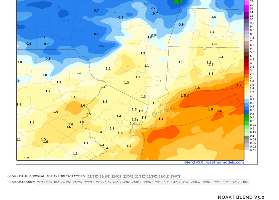
Latest NBE: My thinking is that most of the area will see a general 1.00"-1.50" with some locally higher amounts. The NBE has lowered the top amounts while raising the lower amounts. The 0.50" figure will be confined to locations farther from the NYC area than had been my thinking last evening. The 6z GFS, 0z GGEM and 0z AIFS are in good agreement. The 0z ECMWF became notably wetter. However, it is an outlier among the operational models. The key to achieving higher amounts, particularly those on the ECMWF, would be convective activity, possibly training thunderstorms. At present, most of the convective activity will likely take place south of the NYC region
- Today
-
feeling chilly had the heat on last night wore a sweatshirt my kind of temps.


